- Marine Corps Base Hawaii
-
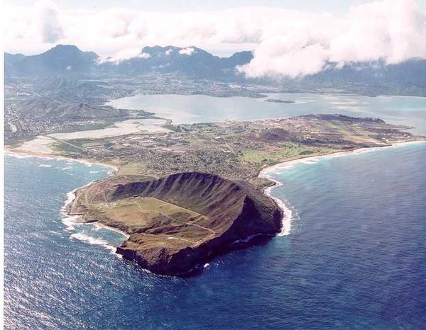
Marine Corps Base Hawaii Mokapu Peninsula, Oahu, Hawaiʻi 
Marine Corps Base Hawaii Insignia
 Shown within Hawaii
Type Military base Coordinates 21°26′37″N 157°44′56″W / 21.44361°N 157.74889°WCoordinates: 21°26′37″N 157°44′56″W / 21.44361°N 157.74889°W Built 1919 Built by United States Army, United States Navy In use 1918-1949, 1952-present Controlled by United States Marine Corps Garrison Combat Logistics Battalion 3
3rd Marine Regiment
Marine Aircraft Group 24
3rd Radio BattalionBattles/wars Pacific War Events Winter White House 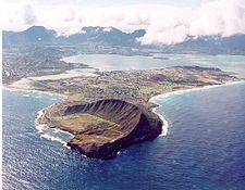
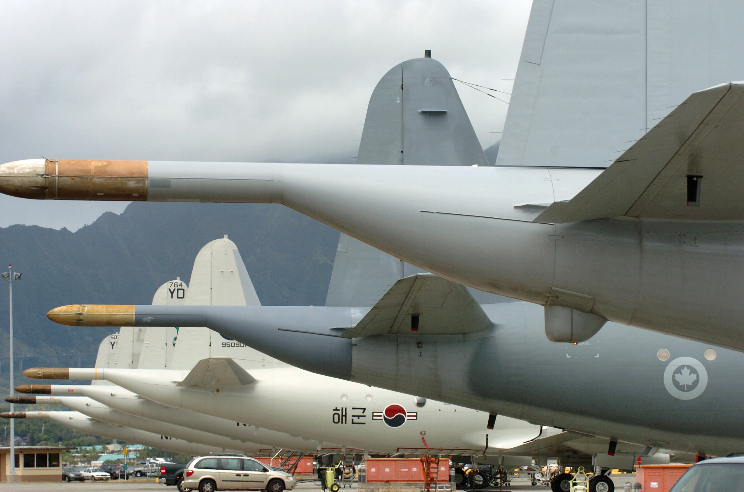
Aerial photograph of Marine Corps Base Hawaii.Marine Corps Base Hawaii (MCBH), formerly Marine Corps Air Station, Kaneohe Bay and originally Naval Air Station Kaneohe Bay, is a U.S. Marine Corps base facility and air station located on the Mokapu Peninsula of windward O'ahu in the City & County of Honolulu. As of the 2000 Census, the base had a total population of 11,827. Marine Corps Base Hawaii, Kaneohe Bay is home to Marines, Sailors, their family members, and civilian employees. The United States Marine Corps operates a 7,800-foot (2,400 m) runway at the base.
MCBH is home for Combat Logistics Battalion 3, the 3rd Marine Regiment, Marine Aircraft Group 24 and 3rd Radio Battalion.
The base lies between the two largest windward O'ahu communities of Kailua and Kāne'ohe and the main gate is reached at the eastern end of Interstate H-3. The main access to the base is by either H-3 or by Mokapu Road. MCB Hawaii is located on the windward side of Oahu, approximately 12 miles (19 km) northeast of Honolulu. Marine Corps Base Hawaii, occupies the entire Mokapu Peninsula, of 2,951 acres (11.94 km2). Two areas of the base are classified conservation land which includes the Ulupau Crater area (north east peninsula) and the Nuupia Pond area (at the Mokapu Road).
Contents
History
 Old MCAS Kaneohe Bay insignia
In 1918, President Woodrow Wilson designated 322 acres (1.30 km2) of land on Mokapu Peninsula for the military. The Kuwaahoe Military Reservation, became known later, in 1942 as “Fort Hase”. In 1941, Army artillery units moved into the area. In 1939, the Navy constructed a small seaplane base and upon its completion, Naval Air Station Kaneohe Bay's role was expanded to include the administration of the Kaneohe Bay Naval Defense Sea Area.
Attack on Pearl Harbor
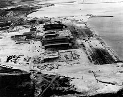 Aerial Photograph of Naval Air Station Kaneohe Bay two days after the Attack on Pearl Harbor.
On December 7, 1941, Naval Air Station Kaneohe Bay was attacked approximately 9 minutes prior to the attack on Pearl Harbor.
Post WWII
In 1951, the Marines assumed control of the air station activities when naval aviation moved to Barbers Point Naval Air Station. On January 15, 1952 Marine Corps Air Station Kaneohe Bay was commissioned. On 15 April 1994, the Marine Corps consolidated all of its installations in Hawaii. MCAS Kaneohe Bay, Camp H. M. Smith, Molokai Training Support Facility, Manana Family Housing Area, Puuloa Range, and the Pearl City Warehouse Annex combined to form a new command, the Marine Corps Base Hawaii, headquartered at MCBH Kaneohe Bay. All U.S. military units located in Hawaii fall under the command of the U.S. Pacific Command (USPACOM) which is headquartered at Camp H. M. Smith on Oahu. The Commanding General of Marine Forces Pacific (MARFORPAC) also commands 12 Marine Corps bases and stations in Arizona, California, Hawaii and Japan, operational forces in Hawaii and Okinawa Prefecture, and units deployed to Southeast/west Asia.
The base is less than a mile north of Plantation Estate where Barack Obama has set up his Winter White House during Christmas break visits in 2008, 2009 and 2010. During his visits Obama works out at the base and attends various dinners.
Geography
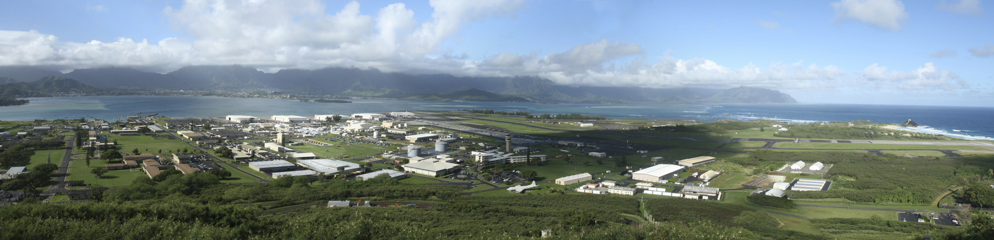
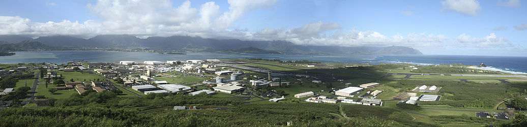 A panoramic view of Marine Corps Base Hawaii taken from the top of K-T.
MCBH is located at 21°26′37″N 157°44′56″W / 21.44361°N 157.74889°W (21.443580, -157.748883).[1]
According to the United States Census Bureau, the base has a total area of 5.8 square miles (15.1 km²), of which, 4.4 square miles (11.4 km²) of it is land and 1.4 square miles (3.7 km²) of it (24.74%) is water.
Demographics

As of the census of 2000,[2] there were 11,827 people, 2,332 households, and 2,283 families residing on the base. The population density was 2,696.2 people per square mile (1,040.2/km²). There were 2,388 housing units at an average density of 544.4/sq mi (210.0/km²). The racial makeup of the base was 66.6% White, 12.1% African American, 1.1% Native American, 5.3% Asian, 1.2% Pacific Islander, 7.6% from other races, and 6.1% from two or more races. 14.6% of the population were Hispanic or Latino of any race.
There were 2,332 households out of which 66.7% have children under the age of 18 living with them, 93.0% were married couples living together, 3.7% have a female householder with no husband present, and 2.1% were non-families. 1.5% of all households were made up of individuals and none had someone living alone who was 65 years of age or older. The average household size was 3.21 and the average family size was 3.23.
On the base the population was spread out with 24.0% under the age of 18, 43.5% from 18 to 24, 31.0% from 25 to 44, 1.4% from 45 to 64, and 0.1% who were 65 years of age or older. The median age was 22 years. For every 100 females there were 202.6 males. For every 100 females age 18 and over, there were 258.8 males.
The median income for a household on the base was $34,757, and the median income for a family was $34,918. Males had a median income of $16,436 versus $21,108 for females. The per capita income for the base was $12,983. About 6.2% of families and 7.2% of the population were below the poverty line, including 9.8% of those under the age of 18 and none of those 65 and older.
Renewable Energy and "Green" Initiatives
Since 2004, MCBH has partnered with Ocean Power Technologies, Inc. to test the generation of electric power from ocean waves using a "PowerBuoy" wave energy converter, one of the first wave power projects in the U.S.[3]
Marine Corps Base Hawaii, under current commanding officer Col. Robert Rice, has stopped using plastic shopping bags aboard the installation, installed solar water heaters on all base housing units, and on Dec. 8, 2010, will debut a "Net Zero" sustainable energy home which uses solar power. The base fleet of government vehicles is also being changed over to hybrid and electric vehicles and most other "FlexFuel" vehicles now operate on E85 ethanol-based fuel. MCB Hawaii installed the first E85 pump in the state of Hawaii in November 2010, which is also the first US military installation in the world to do so.
See also
- U.S. Army Coast Artillery Corps
- 16th Coast Artillery (United States)
- List of United States Marine Corps installations
References
- ^ "US Gazetteer files: 2010, 2000, and 1990". United States Census Bureau. 2011-02-12. http://www.census.gov/geo/www/gazetteer/gazette.html. Retrieved 2011-04-23.
- ^ "American FactFinder". United States Census Bureau. http://factfinder.census.gov. Retrieved 2008-01-31.
- ^ Ocean Power Technologies projects: Oahu
External links
Army 
Air Force  BaseStation
Navy 
Marine Corps  BaseMarine Corps Base HawaiiAir StationCampRangesMCTAB • PuuloaDecomissioned
Coast Guard 
Municipalities and communities of Honolulu County, Hawaii County seat: Honolulu CDPs Ahuimanu | Aiea | 'Ewa Beach | 'Ewa Gentry | Ewa Villages | Halawa | Hale'iwa | Hau'ula | He'eia | Honolulu | Iroquois Point | Kaʻaʻawa | Kahaluu | Kahuku | Kailua | Kalaeloa | Kaneohe | Kawela Bay | Laie | Mā'ili | Mākaha | Mākaha Valley | Makakilo | Marine Corps Base Hawaii | Maunawili | Mililani | Mokulē'ia | Nānākuli | North Ko'olaupoko | Pearl City | Punalu'u | Pūpūkea | Schofield Barracks | Village Park | Wahiawā | Waialua | Wai'anae | Waimalu | Waimanalo Beach | Waimānalo | Waipahu | Waipi'o Acres | Waipio | Whitmore Village

Unincorporated
communitiesAina Haina | Hawaii Kai | Kaimuki | Kapolei | Kunia Camp | Palolo | Pauoa | Waimea Bay
Categories:- Census-designated places in Honolulu County, Hawaii
- Buildings and structures in Honolulu County, Hawaii
- Military facilities in Hawaii
- Neighborhoods in Honolulu, Hawaii
- United States Marine Corps bases
- Populated places on Oahu


Wikimedia Foundation. 2010.