- Ain River
Infobox River | river_name = Ain
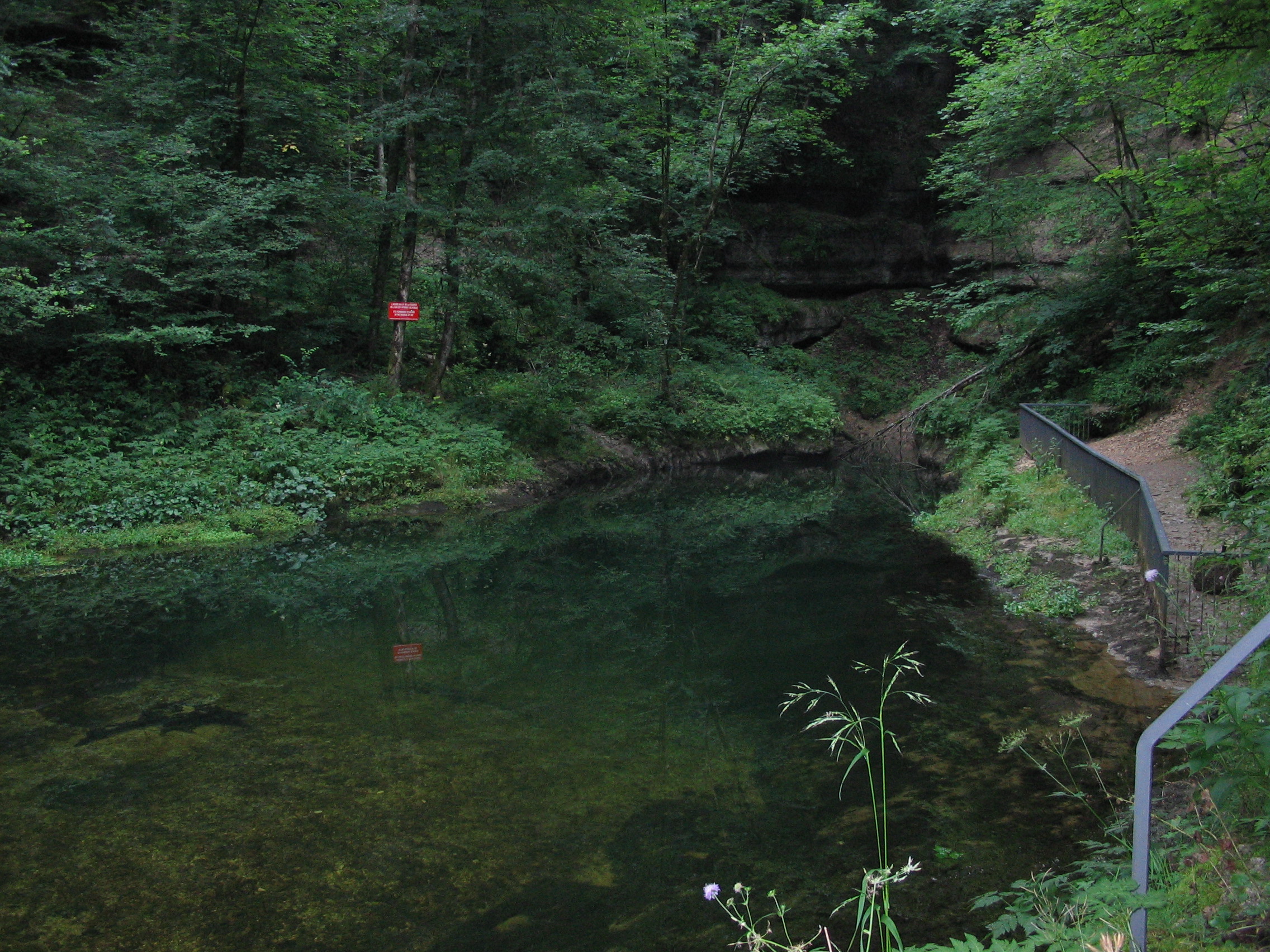
caption = Source of the Ain River.
origin =Jura mountains
coord|46|44|58|N|6|1|24|E|name=source Ain
mouth =Rhône River
coord|45|47|45|N|5|10|10|E|name=Rhône-Ain|display=inline,title
basin_countries =France
length = 190 km
elevation = ± 700 m
discharge = 130 m³/s
watershed = 3,630 km²The Ain is ariver in easternFrance . In theFranco-Provençal language it is known as the En.Global position
The river rises at an altitude of some 700 metres, near the village of
La Favière , in theJurassic limestone of the southern end of theJura mountains and flows into the Rhône about 40 kilometres aboveLyon , some 190 kilometres down the Ain.Its source is in the old county: "
Franche-Comté ". It flows south through the combined lengths of the two départements of
* Jura (named after the mountains: and
*Ain : (named after the river).On the way it passes through the towns of
Champagnole . (05°54'28"E 46°44'53"N) andPont-d'Ain (05°20'13"E 46°02'56"N).The Ain flows into the river Rhône, on the Rhône's right bank, opposite the village of Anthon, approximately 40 km east of
Lyon .Geology
The river flows through two regions, The Jura is, of course, Jurassic but it includes less clay than the Jurassic of
England so Upper or Middle Jurassic means limestone of some sort, possiblymarl (EB 13). The lower river passes overHolocene deposits from the river's own activity amongst rocks of the Middle or UpperPleistocene (CG).The Jura consists of limestone strata crushed into ridges between the forces of the spreading
rift valley of the Saône and theAlps , the latter raised by a collision of the Italian tectonic plate with Europe. The highest ridge is the easternmost and the Ain flows southwards in the lowest valley, which lies towards the western side of the Jura. The westernmost ridge is again rather higher as the plain of the Saône valley is subducted below the Jurassic rocks (Dercourt). The whole has been glaciated but there is relatively littletill remaining in the Jura.The lower Ain flows on the plain where there is much Pleistocene material, much of it glacial till. However, the low scarp between the Pays de
Dombes and the river isMiocene (CG).Economy
The economy is not generally such as to provide riches. Neither is it one which used to require large towns as other than external markets in which to sell. The population is therefore dispersed. The exception to this is the town of
Oyonnax , in the Ange valley which is parallel with the Ain. According to the legend, St Léger gave the monopoly of comb making to Oyonnax in 630. The traditional small products of the region, wood-turning , horn combs and trinkets led to the development of a specialism in theinjection moulding ,vacuum forming and so on of plastics, beginning withcelluloid in 1880. The town's population in 1999 was 24,636 but it is the exception for the river basin (ext links).The
timber is the region's most obvious asset. Some was marketed down river and some converted into charcoal which permitted the rise of water-powered forges working iron from smelters in the Saône valley. There is also pasture producing cheese specialities. In the 20th century, the water power was diverted to the production of hydro-electricity, a fact which aided the early introduction of the plastics industry at Oyonnax. In this, the Ain is central.This is an area of unusually high rainfall for France. But in the summer season, the weather is usually kind. The woodland walks, fishing, sailing and impressive scenery have permitted the development of the outdoor kind of tourism.
Following the river's course
Infancy
The river rises from a spring in the Jurassic limestone at the bottom of a deep
grotto in a small area of lowerCretaceous rock. [http://membres.lycos.fr/cartopassion/page6.htm The top picture on this site gives an idea of it.] The young river is soon joined by streams from other similar sources. The growing stream tumbles down in waterfalls like "le saut de Mailly" to and through a place called "Perte-de-l'Ain" (Generally, "une perte" is a 'loss' but here, a 'swallow' hole.) The small stream disappears briefly in a deep fissure, passing underground in thelimestone . It comes into the open again, in the form of a waterfall. Here, at Bourg-de-Sirod, is the first of the hydrological stations on the river. At theForges de Syam it gathers the waters of the river "Saine" from its left, turning sharply to the north-west towardsChampagnole where it used to provide power for manyforge s and other small industries such as tanneries, grinding mills, sawmills and wood-turning workshops.Youth
After this, for about 25 kilometres, it runs on glacial deposits which overlie the upper Jurassic. First, it flows westwards to just above Pont-du-Navoy where it comes against one of the many ridges of the Jura. This one, the "Côte de l'Heute" rises to some 750 metres but the valley is fairly broad and open as the glacial till of the plain "de Montigny" rises to the east but gently. At Pont-du-Navoy the Jura D471 road runs alongside the river and on it, by a pool is a place called "les Forges"; again, indicating the industry formerly in the valley. At Marigny is another pool, another factory and another hydrological station. The "Lac de Chalain" lies back from the river, in a fold in the ground to the east. At Châtillon, the river crosses the D39 then collects the river "Hérisson" on its left. At this point it broadens into the pool of the dam at Blye: again, a factory. It continues, still on the till, to the N78 at Pont-de-Poitte where the small gorge it once passed through is now flooded by the top reach of the lake of the dam at Vouglans.
Obesity
Lac de Vouglans
But before the end of the till is reached, it begins to broaden into a long sinuous lake, the "
Lac de Vouglans ". This represents the water impounded in the upper Jurassic of the valley bottom by thedam , the "Barrage de Vouglans". The lake, 605 million cubic metres of it, is adapted to leisure use for boating and so on, with various monuments enhancing the landscape of its shores but its purpose is as the main reservoir of the "Électricité de France " (EDF) scheme which extends from here, down the valley. By the dam are an EDF power station and the new village ofVouglans .The D470 crosses it at Pont-de-la-Pyle where there was a Roman bridge and all sorts of crossings of the river since. They have not all withstood the river in spate. It is an ancient crossing point as it is opposite a gap in the hill ridge to the west, which continues the "Côte de l'Heute" southwards. In a land where such ridges are a feature of the landscape, such a gap has a name: a "cluse". This is "La Cluse de la Pyle".
The last of the old bridges was of metal but it went in 1968 as the road had to be raised above the level of the new lake which also drowned 16 square kilometres of land. On that land were several villages and hamlets and the charterhouse of Vaucluse, ("vallis clausa"). It had been founded in 1125 in the 'enclosed valley'. This collection of buildings, built on a terrace supported by an arcade alongside the river and reached by a ferry was to be demolished. Thanks to a group of friends, the main features were dismantled and re-erected above the reach of the lake. What is now hidden is the range of old industrial sites which used the river's power.
In general, the upper Jurassic rocks are heavily forested while the lower Cretaceous and Pleistocene deposits are free of trees. Thus, for most of the stretch below Champagnole, the trees are at a distance from the river but from about two kilometres south of the head of the lake, "
Pont-de-Poitte ", the trees clad its shores. In part, this is the "Forêt de Vaucluse" on the hillside above the site of themonastery .This zone of Jurassic rocks down which a glacier has flowed, having spilled out from the
Swiss plateau in the vicinity ofLake Neuchâtel , is riddled with faults, ridges and valleys from the Alpineorogeny . The features all tend north-east to south-west in the vicinity of the source of the river and become north to south by the time Vouglans is passed. To the west of the valley, the Jurassic andTriassic rocks rise to the ridge beyond which the Pays deBresse which is composed of overlying Pleistocene andPliocene deposits, tilts gently towards theRiver Saône . Beyond the Bresse plain, the Jurassic rises again in the "Côte d'Or", backed by the mass of the "Morvan ".One of the cluster of villages below the Barrage is Menouille, where rafts of timber used to be assembled for the passage down-river to
Lyon .Gorges de l'Ain
Below the main reservoir of the hydro-electric scheme, the "Lac de Vouglans", the hills begin to close in. There is a succession of smaller barrages each with its power station. So none of this part of the river is in its natural state, though the setting is generally rural and near the river at least, wooded. A couple of kilometres down form the EDF station is another at le-Saut-Mortier where the river runs close to the steep hillside to its west and the really difficult part of the passage for the
timber rafts used to begin.At
Chancia , the water enters another lake where the Ain receives its tributary, the Bienne. The side valley too, is dammed and has its power station at the "Barrage de Cézinet". On the Ain, the "Barrage de Coiselet" is the dam retaining the lake we have been following and it has its EDF plant. This was where the first of the hydro-electric generators was installed, in 1901. The dangerous gorge gave way to the waters of the present "Barrage de Coiselet" which turned the confluence of the River Bienne with the Ain into the head of the lake. The lake now made a convenient place for assembling the timber rafts of their handlers, the "radeliers". From there the lake and river form the boundary between the départements of Jura and Ain and we have followed the river for about half its length.Shortly below the barrage, Just below the "Barrage de Coiselet" the Ain gathers the waters of the river Oignin which flows northwards in the same fold in the land as is occupied by the lake. This is a good example of the trellised nature of the drainage pattern in the region. The Ain flows southwards and is joined by the Oignin which flows northwards but the main tributary of the latter is the Ange which flows southwards. The Ange valley is where Oyonnax lies. That town is just over the ridge, five kilometres as the crow flies, from the dam at Coiselet.
The united rivers turn westwards and make another kink, gathering a tributary in the next fold, this time from the right and called the River Valouse. The bottom of this fold is a fault along which the rivers flow. It sets the conditions for the next segment of the valley. These are the "Gorges de l'Ain" in which there are four EDF plants in 30 km. The river is still mainly on upper Jurassic geology but with small patches of lower Cretaceous, middle and lower Jurassic. Nearby, there are small areas of Pleistocene and Triassic. The mixture is not surprising on such faulted and glaciated ground.
For about 13 km, from the head of the lake at Chancia to the confluence with the Valouse, the Ain forms the boundary between the départements of Jura and Ain and 7 km beyond that it reaches the "Epaulette de Cize", a name which comes from the shape of a small but pronounced meander near the village of Cize. The water is now pounded into the bottom of the gorge by the dam there and the old economy of its shore is replaced by catering for anglers and campers. This happened around 1930 until when, they built river craft at Thiorette and milled at Corveissiat. At the EDF dam, the river breaks away from the fault and makes its tight loop. In the middle of the loop is an impressive viaduct with the Bourg en Bresse to Saint Claude railway on the top level from which the trains enter straight into a tunnel. On the lower deck is the local road from Poncin to Thoirette. It looks like a slim, two-stage "
Pont du Gard ".Environmental borderlands
About seven km downstream from Cize, the river crosses the D979, a winding road of steep gradients, where the "Gorge de l'Ain" compresses the river most at Serrieres. As on the D470, the old suspension bridge was replaced to bring the road above the waters of an EDF dam, this one is where La Ceuille and Allement face each other across the river. Apart from the dam, La Ceuille is notable for its castle. By now, in the Jura, we have become accustomed to this pattern of narrow valley and raised waters but things are about to change. Below this dam, the "Barrage d'Allement", 17 km downstream from Cize, the Ain is about to leave the Jura geology beyond which it has cut a valley into a plain of Middle and Upper Pleistocene deposits. Though, it has stirred them up so that immediately around the river, they are classed as Holocene. Here, the valley is host to railways, "routes nationales",
Autoroute s, airfields and industrial estates. It begins with the A40 bridge just above Poncin, in the last of the Jura.But we have not quite left the hills yet. Viewed from downstream, this entrance to the narrow valleys was obviously seen as important. There are the remains of several castles in the area around the entrance to the narrow part of the Ain Valley, as there are in a similar position on the Rhône but in that case, the transition between plain and hills is not so clearly defined. The Ain castles may be found at
Abergement-de-Varay ,Ambronay ,La Ceuille ,Chenavel ,Chiloup ,Hauterive ,Jujurieux , Neuville,Oussiat ,Pinel ,Poncin , Pont-d'Ain,Saint-Gras ,Saint-Martin-du-Mont ,Varambon andVarey .The A40 Autoroute crosses just above Poncin and just below the village, where the Jurassic banks narrow the river for the last time, it passes the Upper
Palaeolithic (earlyMagdalenian ) archaeological site, discovered in 1913, la Colombière. Here, what may be the earliest representation of an arrow was found engraved on a stone. The presence of the site here may not be coincidental. The people of 20,000 years ago were hunter-gatherers who will have spent at least part of their year hunting herds in the increasingly cold climate. It is at the entrances to narrow valleys that the herds from the plain often concentrate in the course of their migrations up a valley. The Cro-Magnon people will have been here to make use of that seasonal bounty in a way comparable with the medieval view of the same area.Maturity
However, the plain to the west of the river is still quite rural. It is known as the "Pays de Dombes". Geologically, it is part of the Pays de Bresse but its traditional form of 'agriculture' is fish farming. It is therefore strewn with hundreds of mostly artificial, lakes. The Dombes and the Ain valley in the Jura have an economic factor in common though; their markets were down-river in or through Lyon.
At
Oussiat , there is a reminder of another, later traditional trade of the region, an old silk mill. The silk trade of the region was marketed through Lyon. It was typical of the markets through which Charles Worth learned his business as a draper, a knowledge which he put to use in founding theHouse of Worth .About seven kilometres from la Colombière, the river reaches the N84 and A42 as it comes to the margin of the Dombes at and just below Pont d'Ain. Here is the fourth of the river's hydrological stations.
Pont d'Ain was the centre for the governing of the region when it was in the hands of the Dukes of Savoy. Their castle remains. See
Philibert le Beau of Savoy . Among the modern structures, there remain the buildings of the old grinding mills. Now in the plain, the river is not impounded for hydro-electrical use so the watercourse itself remains in a more natural state as abraided river . Immediately below the motorway bridge, from the right, it receives its last tributary from the Jurassic valleys, the Suran. This is near Varambon, an old river port, overlooked by its castle, the château De Boissieu but it now looks across the river at the motorway.The bridge of Pont-de-l'Ain carries the N 75. Here on the plain there is room for the old main roads to be straight. For about eight kilometres, between here and
Villieu-Loyes-Mollon , the river flows at one edge of its flood plain along the smallescarpment at the edge of the Pays de Dombes. The spaces between the villages such as [http://www.marryat-france.com/etat.htm Villette-sur-Ain and Priay.] on the "côte" are small, all the way along. On the higher side of the flood plain is the small town ofAmbérieu-en-Bugey . To the east of that, the lower end of the Jura can still be seen. The river rambles over its bed between temporary islands of pebbles or silt and makes a fine terrain for lovers of fly-fishing and it was here that the youngAntoine de Saint Exupéry came from Lyon for theswimming . The plain is riddled with small streams of which the Albarine is most notable. The small region of the river plain, between the Ain and the Jura hills is known as theBugey .The current becomes stronger as the stream passes among banks of pebbles and against
gabion s put in to protect the banks pastMollon but it opens out to its ramblings again before passing under the N84, the road which links the Jura with Lyon. At almost the same point it crosses the A42, the motorway linking Lyon with the eastern side of the Saône valley and with the Jura. Just below these crossings, at Chazay-sur-Ain is situated the fifth and lowest of its hydrological stations, about fifteen kilometres short of its confluence with the Rhône. From here on, the eastern border of the pays de Bugey is marked by the Rhône.The Ain rambles its last few kilometres through open country but the large military "Camp de la Valbone" and the "Bergères" and "Plaine de l'Ain" industrial estates are not far away, neither is the atomic power station, the "Centrale Nucléaire de Bugey". Having passed through the last woods and past the last villages, the Ain enters the Rhône about ten kilometres short of the Lyon-Saint-Exupéry airport, named after Antoine, the aviator and the town where he was born.
Fauna
The Ain is very rich in fish, including trout, in particular "Salmo trutta fario"; grayling, especially the common grayling "Thymallys thymallus"; pike, perch, barbel, bream, carp, tench, roach, Eurasian minnow, chub and loach.
Numerous birds populate the river's banks: duck, egret, swans, heron, and snipe. Beavers are also present and construct numerous dams while wild boar and roe deer are found in the woods and forests bordering the stream. Otters have once more been seen since 2003, so demonstrating a general improvement in the quality of the waters.
Development
The river's natural surroundings remain relatively wild, and are the subject of an environmental scheme by the name of a SDAGE (Schéma Directeur d’Aménagement et de Gestion des Eaux), set up under a
French law . Its aim is to conserve and make the best use of the whole hydrological system by viewing it as a unit. That involves reconciling the hydro-electric stations with the boating, fishing, swimming and perhaps water extraction in view of the tendency to industrial development on the reclaimed delta land at its confluence with the Rhone at its southern end.
=Hydrographic statistics=References
*"Carte géologique de la France à l'échelle du millionième 6th edn," (2003) ISBN 2-7159-2158-6 [CG]
*"Michelin France Tourist and Motoring Atlas" (2002) ISBN 2-06-100128-9 [Mich]
*Bartholomew, J.G. "The Times Survey Atlas of the World" (1922) [Times]
*Dercourt, J. "Géologie et Géodynamique de La France Outre-mer et européenne" 3rd edn. (2002) ISBN 2-10-006459-2 [Dercourt]
*"Encyclopediædia Britannica" (1960) [EB]
*Fauna paragraph translated from the French Wikipedia article.
* [http://sandre.eaufrance.fr/app/chainage/courdo/htm/V2--0200.php?cg=V2--0200 The Ain at the Sandre database]General external links
* [http://membres.lycos.fr/cartopassion/page6.htm This is in French but the old pictures give an idea of the geology, from source to confluence]
* [http://www.ign.fr/rubrique.asp?rbr_id=1087&CommuneId=39004#altitude Cartographical details of the source. In French]
* [http://www.comte.com/english/index.html The dairy component of the economy]
* [http://www.ecotec.com/idele/themes/lisbon/oyonnax/ Plastics valley]
* [http://www.plasticsvallee.com/anglais/cdcmenu_cdr.htm Small manufacturing]Archaeology
* [http://www.rupestre.net/tracce/12/chauv.html Upper Palaeolithic cave art]
Learned paper
*MAYET, L. y PISSOT, J. (1915): Abri sous roche préhistorique de La Colombière près Pocin (Ain). Faculté des Sciences de Lyon. Laboratoire de Géologie et Paléontologie. section d'Anthropologie et Paléontologie, Lyon. 193 pp.
Wikimedia Foundation. 2010.