- Landsford Canal
Infobox nrhp
name = Landsford Canal
nrhp_type =
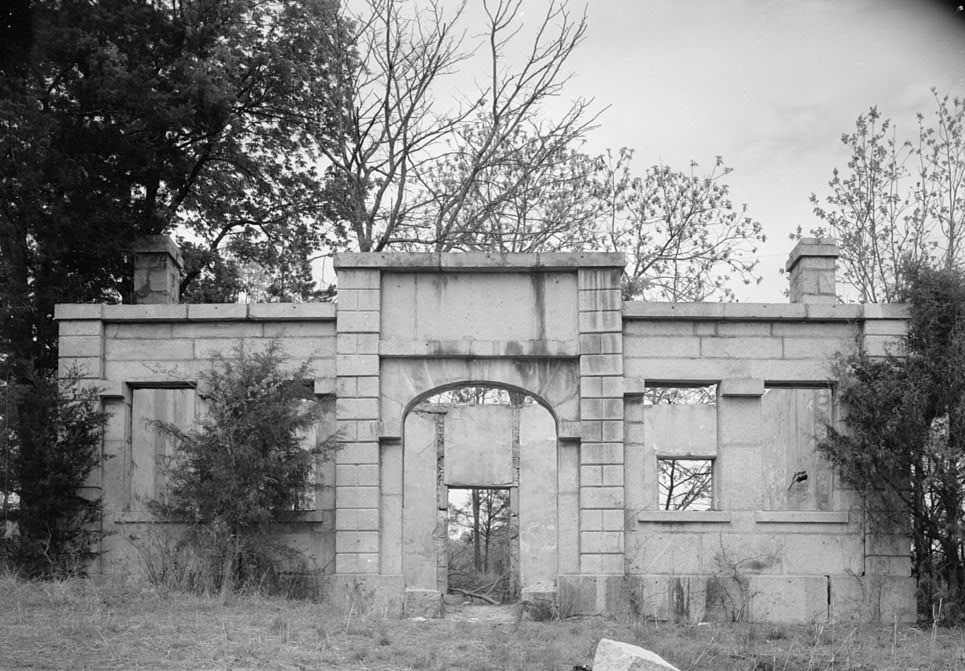
caption = The Lock Keeper's House at Rocky Mount Canal near Great Falls, downstream of the Landsford Canal. This was moved to the Landsford Canal.
location =Chester County, South Carolina
nearest_city =Chester, South Carolina
lat_degrees =
lat_minutes =
lat_seconds =
lat_direction = N
long_degrees =
long_minutes =
long_seconds =
long_direction = W
area =
built =1820 -1823
architect =Robert Mills
architecture =
added =December 3 1969
visitation_num =
visitation_year =
refnum = 69000163
mpsub =
governing_body =South Carolina Department of Parks and TourismThe Landford Canal was the furthest upstream of a series of canals built on the Catawba and Wateree Rivers to provide a direct water route between the upstate settlements and the towns on the fall line. It is located along the Catawba River in
Chester County, South Carolina east of Chester. It is named for an early settler, Thomas Land, who owned the land with a ford across the Catawba River. It is the centerpiece of theLandsford Canal State Park .History
In
1820 , construction of the canal, which was designed by Robert Mills, began using slave labor and skilled laborers from the northernUnited States under the supervision of Robert Leckie. It was 2 mi (3.2 km) long. It was 12 ft ( 3.7 m) wide and ten ft (3 m) deep. It had five locks for the 32 ft (9.8 m) descent of the river.The canal was not a financial success. In
1824 , one of the locks collapsed due to a poor foundation. Canal traffic, which was never high, had apparently ceased by1840 . The granite locks and the lock keeper's house survive. [Edgar, Walter, ed. "The South Carolina Encyclopedia", University of South Carolina Press, 2006, p. 534, ISBN 1-57003-598-2]The Landsford Canal is on the
National Register of Historic Places , No. 69000163. The South Carolina Department of Archives and History has additional pictures and information, [ [http://www.nationalregister.sc.gov/chester/S10817712001/index.htm Pictures of the Landford Canal.] ] and copies of the nomination forms. [ [http://www.nationalregister.sc.gov/chester/S10817712001/S10817712001.pdf Landsford Canal nomination form.] ]There are additional pictures, architectural drawings, and information about the lock keeper's house available from the
Historic American Building Survey at theLibrary of Congress . [ [http://lcweb2.loc.gov/pp/pphome.html Prints and Photographs Online Catalog - Search for "Rocky Mount Canal"] ] Their documentation indicates the the lock keeper's house at Landsford Canal was moved from Rocky Mount Canal near Great Falls downstream.References
ee also
*
List of canals in the United States
Wikimedia Foundation. 2010.