- Malheur National Forest
-
Contents
Malheur National Forest IUCN Category VI (Managed Resource Protected Area)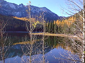
Strawberry Lake in Malheur National ForestLocation Oregon, USA Nearest city Canyon City, Oregon Coordinates 44°17′00″N 118°47′04″W / 44.2832129°N 118.7843893°WCoordinates: 44°17′00″N 118°47′04″W / 44.2832129°N 118.7843893°W[1] Area 1,700,000 acres (6,880 km2) Visitors 242,000 (in 2006)[2] Governing body U.S. Forest Service  Monument Rock in Malheur NF
The Malheur National Forest is a National Forest in the U.S. state of Oregon. It contains 1.7 million acres (6900 km²) in the Blue Mountains of eastern Oregon. The forest include high desert grasslands, sage, juniper, pine, fir, and other tree species. Elevations vary from about 4000 feet (1200 m) to the 9038 foot (2754 m) peak of Strawberry Mountain. The Strawberry Mountains extend east to west through the center of the forest. U.S. Route 395 runs south to north through the forest, while U.S. Route 26 runs east-west.
The forest is managed for timber extraction, cattle grazing, gold mining and wilderness use by the Forest Service, a division of the US Department of Agriculture. A 1993 Forest Service study estimated that the extent of old growth in the forest was 312,000 acres (126,000 ha)[3].
The forest was established by President Theodore Roosevelt on June 13, 1908 and is named after the Malheur River, from the French, meaning literally "misfortune".
In descending order of land area the forest is located in parts of Grant, Harney, Baker, and Malheur counties. There are three ranger districts in the forest, with offices in John Day, Prairie City, and Hines, Oregon.
The Malheur National Forest contains the largest known organism (by area) in the world: an Armillaria solidipes that spans 2200 acres (8.9 km²).[4]
Wilderness
There are two wilderness areas in Malheur National Forest.
- Strawberry Mountain Wilderness at 68,700 acres (278 km2)
- Monument Rock Wilderness at 19,620 acres (79 km2), located partially within the Wallowa–Whitman National Forest
See also
References
- ^ "Malheur National Forest". Geographic Names Information System, U.S. Geological Survey. http://geonames.usgs.gov/pls/gnispublic/f?p=gnispq:3:::NO::P3_FID:1155108. Retrieved 2009-04-11.
- ^ "Revised Visitation Estimates". National Forest Service. http://www.fs.fed.us/recreation/programs/nvum/revised_vis_est.pdf.
- ^ Bolsinger, Charles L.; Waddell, Karen L. (1993). Area of old-growth forests in California, Oregon, and Washington. United States Forest Service, Pacific Northwest Research Station. Resource Bulletin PNW-RB-197. http://www.fs.fed.us/pnw/pubs/pnw_rb197.pdf
- ^ Beale, Bob. 10 April 2003. Humungous fungus: world's largest organism? at Environment & Nature News, ABC Online. Accessed 25 June 2008.
External links
- Malheur National Forest home page
- Grant County Chamber of Commerce Information
- Forest Service home page
- Department of Agriculture home page
- Cedar Grove Botanical Area
Protected Areas of Oregon Federal State Arcadia Beach • Bob Straub • Bradley • Cape Kiwanda • Cape Lookout • Cape Meares • Clay Myers at Whalen Island • Del Rey Beach • Ecola • Elmer Feldenheimer • Fishing Rock • Fort Stevens • Gearhart Ocean • Haystack Hill • Hug Point • John Yeon • Manhattan Beach • Munson Creek Falls • Neahkahnie–Manzanita • Nehalem Bay • Oceanside Beach • Oswald West • Rockaway Beach • Sunset Beach • Sunset Highway Forest • Symons • Tolovana Beach • Tolovana Beach • Twin Rocks • Wilson River Highway Forest
Agate Beach • Alsea Bay • Beachside • Beaver Creek • Beverly Beach • Boiler Bay • Carl G. Washburne • Collins Creek • D River • Darlingtonia • Devils Lake • Devils Punch Bowl • Driftwood Beach • Ellmaker • Fogarty Creek • Gleneden Beach • Governor Patterson • H.B. Van Duzer • Heceta Head Lighthouse • Jessie M. Honeyman • Joaquin Miller Forest • L. Presley & Vera C. Gill • Lost Creek • Muriel O. Ponsler • Neptune • Neskowin Beach • Ona Beach • Otter Crest • Pritchard • Roads End • Rocky Creek • San Marine • Seal Rock • Smelt Sands • South Beach • Stonefield Beach • Tokatee Klootchman • W. B. Nelson • Whale Watching • Yachats • Yachats Ocean Road • Yaquina Bay
Albert H. Powers • Alfred A. Loeb • Arizona Beach • Bandon • Bolon Island Tideways • Bullards Beach • Cape Arago • Cape Blanco • Cape Sebastian • Conde B. McCullough • Coquille Myrtle Grove • Crissey Field • Elk Creek Tunnel Forest • Face Rock • Floras Lake • Geisel Monument • Golden and Silver Falls • Harris Beach • Hoffman • Humbug Mountain • Hutchinson • Maria C. Jackson • McVay Rock • Ophir • Otter Point • Paradise Point • Pistol River • Port Orford Cedar Forest • Port Orford Heads • Samuel H. Boardman • Seven Devils • Shore Acres • Sisters Rock • Sunset Bay • Sweet Myrtle • Umpqua • Umpqua Lighthouse • Umpqua Myrtle • William M. Tugman • Winchuck • Yoakam Point
Banks–Vernonia • Bonnie Lure • Government Island • L. L. "Stub" Stewart • Mary S. Young • Milo McIver • Tryon Creek • Willamette Stone
Ainsworth • Benson • Bonneville • Bridal Veil Falls • Crown Point • Dabney • Dalton Point • George W. Joseph • Guy W. Talbot • Historic Columbia River Highway • John B. Yeon • Koberg Beach • Lang Forest • Lewis and Clark • Lindsey Creek • Mayer • McLoughlin • Memaloose • Multnomah Falls • Portland Women's Forum • Rocky Butte • Rooster Rock • Seneca Fouts • Shepperd's Dell • Sheridan • Starvation Creek • Viento • Vinzenz Lausmann • Wyeth • Wygant
Alderwood • Bald Peak • Blachly Mountain Forest • Bowers Rock • Cascadia • Champoeg • Detroit Lake • Dexter • Elijah Bristow • Erratic Rock • Fall Creek • Fort Yamhill • Holman • Jasper • Lowell • Luckiamute • Maples • Maud Williamson • Molalla River • North Santiam • Sarah Helmick • Silver Falls • State Capitol • Thompson's Mills • Washburne • Willamette Mission
Ben Hur Lampman • Canyon Creek Forest • Casey • Collier Memorial • Illinois River Forks • Jackson F. Kimball • Joseph H. Stewart • Klamath Falls – Lakeview Forest • OC&E Woods Line • Prospect • Rough and Ready Forest • Stage Coach Forest • TouVelle • Tub Springs • Valley of the Rogue • Wolf Creek Inn
Cline Falls • Deschutes River • Dyer • Elliott Corbett • La Pine • Ochoco • Peter Skene Ogden • Pilot Butte • Prineville Reservoir • Redmond–Bend Juniper • Sisters • Smith Rock • The Cove Palisades • Tumalo • White River Falls
Bates • Battle Mountain Forest • Blue Mountain Forest • Booth • Catherine Creek • Chandler • Clyde Holliday • Crooked Creek • Deadman's Pass • Emigrant Springs • Farewell Bend • Fort Rock • Fort Rock Cave • Frenchglen Hotel • Goose Lake • Hat Rock • Hilgard Junction • Kam Wah Chung • Lake Owyhee • Minam • Ontario • Pete French Round Barn • Red Bridge • Succor Creek • Sumpter Valley Dredge • Ukiah–Dale Forest • Unity Forest • Unity Lake • Wallowa Lake • Wallowa Lake Highway Forest • Wallowa River
Bridge Creek • Dean Creek • Denman • E.E. Wilson • Elkhorn • Fern Ridge • Irrigon • Jewell Meadows • Klamath • Ladd Marsh • Lower Deschutes • Phillip W. Schneider • Prineville • Riverside • Sauvie Island • Snake River Islands • Summer Lake • Wenaha • White River • Willow Creek
Regions Portland metroBlue Lake • Cooper Mountain • Glendoveer • Howell • Oregon Zoo • Oxbow • Smith and Bybee • Mount Talbert
Cities PortlandForest Park • Washington Park
Heritage registers: National Register of Historic Places • National Historic Landmarks • National Natural Landmarks • World Network of Biosphere Reserves Categories:- IUCN Category VI
- National Forests of Oregon
- Protected areas of Grant County, Oregon
- Protected areas of Harney County, Oregon
- Protected areas of Baker County, Oregon
- Protected areas of Malheur County, Oregon
- Oregon geography stubs
- Western United States protected area stubs

Wikimedia Foundation. 2010.