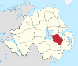
- Lisburn City Council
-
Coordinates: 54°30′40″N 6°02′35″W / 54.511°N 6.043°W
Lisburn City Council Geography 
Area
- TotalRanked 16th of 26
447 km²Admin HQ Lisburn ISO 3166-2 GB-LSB ONS code 95S Demographics Population
- Total (2010)
- DensityRanked
/ km²Community Catholic: 33.4%
Protestant: 62.8%Politics Control No overall control
DUP: 14
Sinn Féin: 5
UUP: 5
Alliance Party: 3
SDLP: 3MLAs Belfast West & Lagan Valley
Sinn Féin: 5
DUP: 4
Alliance Party: 1
SDLP: 1
UUP: 1MPs Jeffrey Donaldson (DUP)
Paul Maskey (Belfast West)Meeting place Website http://www.lisburncity.gov.uk Lisburn City Council is a district council covering an area partly in County Antrim and partly in County Down in Northern Ireland. The council is the second largest in the Belfast Metropolitan Area. Council headquarters are in the city of Lisburn, upon which was conferred city status in May 2002 as a result of the council's success in the Queen Elizabeth II Golden Jubilee competition. It is the second-largest council area in Northern Ireland with over 108,000 residents and an area of 174 square miles (450 km2) of south-west Antrim and north-west Down. It stretches from Glenavy and Dundrod in the north to Dromara and Hillsborough in the south and from Drumbo in the east to Moira and Aghalee in the west.
The council area consists of five electoral areas: Downshire, Dunmurry Cross, Killultagh, Lisburn Town North and Lisburn Town South. It has 30 councillors, last elected in 2005. The current composition is: 12 Democratic Unionist Party (DUP), 7 Ulster Unionist Party (UUP), 4 Sinn Féin, 3 Alliance Party, 3 Social Democratic and Labour Party (SDLP) and 1 Independent Unionist. The current Mayor is Councillor Alderman Paul Porter (DUP), and the Deputy Mayor is Councillor Brian Heading (SDLP). An election was due to take place in May 2009, but was postponed due to an ongoing review of local government.
For elections to the Westminster Parliament, the council area is currently split between the Lagan Valley constituency and the West Belfast constituency. In the 2010 Westminster election, the Glenavy area was placed in the South Antrim constituency, and the Dunmurry area was placed in the West Belfast constituency.[1]
Contents
Constituent cities, towns and villages
2011 Election results
2011 saw the continued advancement of the DUP and Sinn Fein within the council Area. In Downshire, the DUP picked up a seat from the UUP, and in Dunmurray Cross, Sinn Fein gained from the SDLP. However the SDLP loss was compensated by changing demographics in the North Lisburn DEA, where the SDLP took a seat for the first time. There were no changes in the Killutagh or Lisburn Town South DEAs. The election was a notable success for the DUP who succeeded in returning all their candidates with the exception of Ben Mallon a local student standing in Lisburn North.
Party seats change +/- • Democratic Unionist Party 14 +1 • Ulster Unionist Party 5 -2 • Sinn Féin 5 +1 • Social Democratic and Labour Party 3 = • Alliance Party of Northern Ireland 3 = • Independent 0 = Mayors of Lisburn
- 1977 - 78?: Elsie Kelsey, Ulster Unionist Party
- 1978 - 79:
- 1979 - 81: Alderman Dr Samuel Semple MBE, Ulster Unionist Party
- 1981 - 83: Billy Belshaw, Democratic Unionist Party
- 1983 - 85: Maureen McKinney, Ulster Unionist Party
- 1985 - 87: Walter Lilburn, Ulster Unionist Party
- 1987 - 88:
- 1988 - 89: Billy Bleakes, Ulster Unionist Party
- 1990 - 91:
- 1991 - 93: Ivan Davis, Ulster Unionist Party
- 1993 - 94: Seamus Close, Alliance Party of Northern Ireland
- 1994 - 96:
- 1996 - 98?: George Morrison, Ulster Unionist Party
- 1998 - 00: Peter O'Hagan, Social Democratic and Labour Party
- 2000 - 02: Jim Dillon, Ulster Unionist Party
- 2002 - 03: Betty Campbell, Alliance Party of Northern Ireland
- 2003 - 04: Billy Bell, Ulster Unionist Party
- 2004 - 05: Cecil Calvert, Democratic Unionist Party
- 2005 - 06: Jonathan Craig, Democratic Unionist Party
- 2006 - 07: Trevor Lunn, Alliance Party of Northern Ireland
- 2007 - 08: James Tinsley, Democratic Unionist Party
- 2008 - 09: Ronnie Crawford, Ulster Unionist Party
- 2009 - 10: Allan Ewart, Democratic Unionist Party
- 2010 - 11: Paul Porter, Democratic Unionist Party
Review of Public Administration
Under the Review of Public Administration (RPA) the Council is due to merge with Castlereagh Borough Council in 2011 to form a single council for the enlarged area totalling 540 km² and a population of 175,182.[2] The next election was due to take place in May 2009, but on 25 April 2008, Shaun Woodward, Secretary of State for Northern Ireland announced that the scheduled 2009 district council elections were to be postponed until the introduction of the eleven new councils in 2011.[3]
See also
- Local Councils in Northern Ireland
References
- ^ [1]
- ^ "Minister Foster announces decisions on Local Government Reform". DoE. http://www.doeni.gov.uk/index/local_government/minister_foster_announces_decisions_on_local_government_reform.htm. Retrieved 2008-05-31.
- ^ Northern Ireland elections are postponed, BBC News, 25 April 2008, accessed 27 April 2008
External links
Local authorities of Northern Ireland Antrim · Ards · Armagh · Ballymena · Ballymoney · Banbridge · Belfast · Carrickfergus · Castlereagh · Coleraine · Cookstown · Craigavon · Derry · Down · Dungannon and South Tyrone · Fermanagh · Larne · Limavady · Lisburn · Magherafelt · Moyle · Newry and Mourne · Newtownabbey · North Down · Omagh · Strabane
Categories:- Politics of County Antrim
- Politics of County Down
- Lisburn
- Local authorities of Northern Ireland
Wikimedia Foundation. 2010.
