- Ouse Valley Railway
-
Coordinates: 51°01′59″N 0°06′50″W / 51.033°N 0.114°W
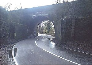 Skew bridge located near the Ouse Valley Viaduct on the London to Brighton main line was to be one starting point. The abutments in the foreground are part of the extension built for the Ouse Valley line.
Ouse Valley Railway Legend


Brighton  (Main Line)
 London

Lindfield 

Future Culver Junction to East Grinstead line Sheffield Park* Piltdown & Shortbridge* 
To Lewes 
Uckfield 
Future line to Oxted Framfield* East Hoathly* Chiddingly* Lower Horsebridge* To Polegate Hailsham Future line to Eridge Wartling* Little Common* Bexhill on Sea* Bulverhythe* 

Polegate (line to) St LeonardsLegend 
Railways open in 1863 
Ouse Valley Railway Railways opened after 1863 
Station open in 1863 
Proposed or possible (*) station.[1] The Ouse Valley Railway was a railway which was to have formed part of the London, Brighton & South Coast Railway (LBSCR). It was authorised by an Act of Parliament and construction of the 20 miles (32 km) long line was begun, but not completed. It never opened to traffic.
Contents
Background
In the 1860s, both the South Eastern Railway and the London, Chatham and Dover Railway were proposing to build railways to Brighton and Eastbourne. To counter this threat, the LBSCR proposed to build a 20 miles (32 km) long railway linking the Haywards Heath, Uckfield, and Hailsham. It was accepted by the LBSCR that the line would not be a profitable one but they wanted to keep other companies out of their territory.[2] Authorisation was given to further extend the line to St Leonards.[3] One tactic to be employed by the LBSCR was to build the line as slowly as possible, delaying its opening to force other companies to look elsewhere to build their lines.[4]
Authorisation
An Act of Parliament was needed to construct the line. This was sought in 1863 and granted - 26&27 Vict c.xxxv s.13, L.B. & S.C.R.(Ouse Valley Line) 1864.[5] In 1864, authorisation was received to extend the line to St Leonards.[3]
Route
The line was to leave the Brighton Main Line just south of Balcombe Viaduct and pass through Lindfield. From there the railway would follow the Ouse Valley to Sheffield Park and then pass north of Newick to Shortbridge and connect with the railway south of Uckfield, which was then a terminus for the line from Lewes.[2]
The line would then pass through Framfield, East Hoathly, Chiddingly and Lower Horsebridge before joining the railway at Hailsham, which at that time was a terminus for the line from Polegate.[2] The line would have then continued across country to Bexhill on Sea and St Leonards.[3]
Construction and abandonment
Construction of the line between Haywards Heath and Uckfield began in May 1866. This was the month in which Overend & Gurney's Bank collapsed. Overend & Gurney's were major financiers of railway construction projects at the time. Work stopped in February 1867 and was not resumed.[3]
Remains
There is still much to be seen of the line between Haywards Heath and Uckfield. Skew Bridge across the B2036 at between Haywards Heath and Balcombe (TQ 325 273) has extended abutments where the railway would have passed over the road. Each side of the road at Borde Hill (TQ 325 273) embankments survive. A cutting leads to what would have been a tunnel at Kenwards Farm (TQ 325 273). In Lindfield an embankment at TQ 348 264 survives. Lindfield station would have been at TQ 351 261 with recently found remains of a brick making kiln in what would have been the station yard. South of Uckfield, and embankment and the only completed bridge on the line (TQ 456 205) reported destroyed during the construction of the Uckfield Bypass in the 1990s is still in position although in decrepit state. Visited although not photographed September 2009.[3]. Visited in April 2009 - About one mile south west of Uckfield there are two sections of embankments and cuttings (TQ 456 205 - TQ 452 207) and (TQ 451 208 - TQ 447 209). Remains of one bridge abutment is visible adjacent to a footpath at TQ 456 205.
See also
- List of never used railways
References
- ^ Only Lindfield confirmed by Oppitz. Other stations between Lindfield and Hailsham mentioned as possibilities by Oppitz. Stations between Hailsham and St Leonards indicate localities the line would have passed through.
- ^ a b c Oppitz, Leslie (1987). Sussex Railways Remembered. Newbury: Countryside Books. pp. p87-94. ISBN 0 905392 99 X.
- ^ a b c d e "Ouse Valley". Sussex Industrial Archaeological Society. http://www.sussexias.co.uk/articles/branch_3a.htm. Retrieved 24 September 2009.
- ^ "A PICTORIAL GUIDE TO THIS MYSTERIOUS RAIL LINE". Horsted Keynes. http://www.horstedkeynes.com/ousevalley.html. Retrieved 24 September 2009.
- ^ "Acts of the Parliaments of the United Kingdom Part 53 (1863)". Office of Public Sector Information. http://www.opsi.gov.uk/chron-tables/local/chron053. Retrieved 24 September 2009.
External links
- A comprehensive illustrated guide to what is left to be seen on the ground.
- A video of the Ouse Valley Railway remains
Further reading
- Sekon, G A. "Abandoned Lines of the L.B.S.C.R". The Railway Magazine (November 1946): p346.
- Sekon, G A. "Abandoned Lines of the L.B.S.C.R". The Railway Magazine (December 1946): p365.
- Robbins, Michael. "The Ouse Valley Railway". The Railway Magazine (September 1951): p629.
Categories:- Rail transport in East Sussex
- Rail transport in West Sussex
- Railways authorised but not built in the United Kingdom

Wikimedia Foundation. 2010.