- San Francisco Maritime National Historical Park
-
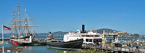
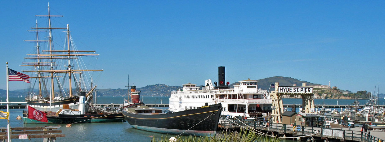
San Francisco Maritime National Historical Park Historic ships docked at Hyde Street Pier, San Francisco Maritime National Historic Park
Location San Francisco, California, USA Nearest city San Francisco, California Coordinates 37°48′23″N 122°25′25″W / 37.80639°N 122.42361°WCoordinates: 37°48′23″N 122°25′25″W / 37.80639°N 122.42361°W Area 50 acres (0.2 km²) Established June 27, 1988 Visitors 3,976,056 (in 2005) Governing body San Francisco Maritime National Historic SiteLocation: Fort Mason, Bld. 201, San Francisco, California Area: 0 acres (0 ha) NRHP Reference#: 01000281
[1]Added to NRHP: June 27, 1988 The San Francisco Maritime National Historical Park is located in San Francisco, California, USA. The park includes a fleet of historic vessels, a visitor center, a maritime museum, and a library/research facility. The park is sometimes incorrectly referred to as the San Francisco Maritime Museum -- a name that dates from 1951, but changed when the collections were acquired by the National Park Service, in 1978. Today's San Francisco Maritime National Historical Park was authorized in 1988; the maritime museum is among the park's many cultural resources. The park also incorporates the Aquatic Park Historic District, bounded by Van Ness Avenue, Polk Street, and Hyde Street.
Contents
Historic vessel fleet
The historic fleet of the San Francisco Maritime National Historical Park is moored at the park's Hyde Street Pier. The fleet consists of the following major vessels:
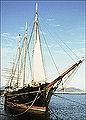
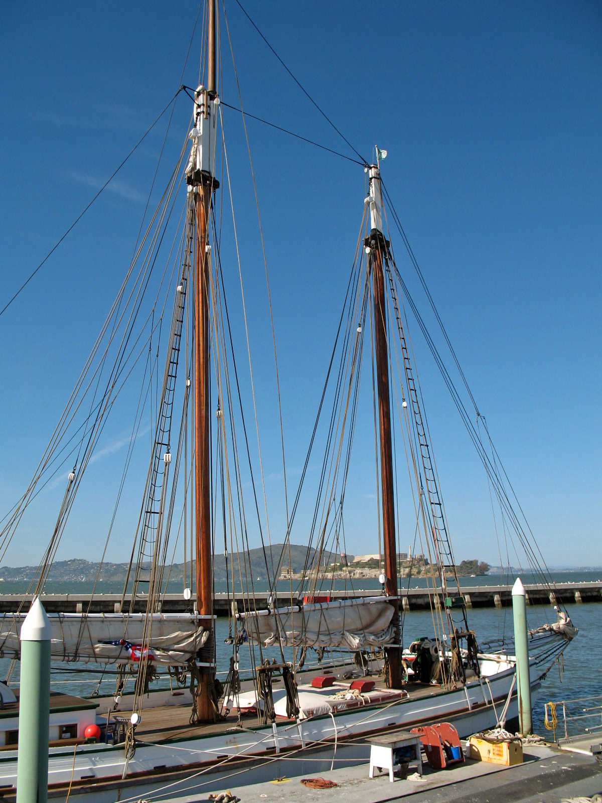
- Balclutha, an 1886 built square rigged sailing ship.
- C.A. Thayer, an 1895 built schooner.
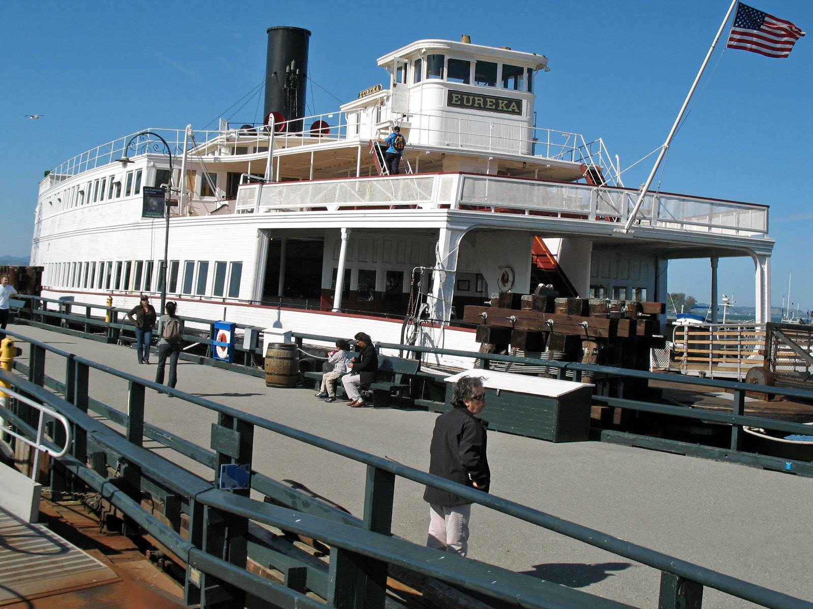
- Eureka, an 1890 built steam ferryboat.
- Alma, an 1891 built scow schooner.
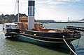
- Hercules, a 1907 built steam tug.
- Eppleton Hall, a 1914 built paddlewheel tug.
-

Square rig sailing ship Balclutha -
Paddlewheel tug Eppleton Hall -

Steam ferryboat Eureka -
Lumber schooner C.A. Thayer
The fleet also includes over one hundred small craft.
Visitor Center
The Visitor Center is housed in the park's 1909 waterfront warehouse, located at the corner of Hyde and Jefferson Streets. The City of San Francisco declared the four-story brick structure an historic landmark in 1974, and the building was listed on the National Register of Historic Places in 1975. Inside, exhibits (including a first order Fresnel lighthouse lens and a shipwrecked boat) tell the story of San Francisco’s colorful and diverse maritime heritage. The visitor center also contains a theater, the Sailor's Den (a branch of the park's maritime library), and a ranger-staffed information desk.
Maritime Museum
 The Park's Maritime Museum.
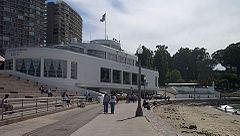
The maritime museum was until recently housed in a Streamline Moderne (late Art Deco) building that is the centerpiece of the Aquatic Park Historic District, a National Historic Landmark at the foot of Polk Street and a minute's walk from the visitor center and Hyde Street Pier. The building was originally built (starting in 1936) by the WPA as a public bathhouse, and its interior is decorated with fantastic and colorful murals. The architects were William Mooser Jr. and William Mooser III.
The Steamship Room illustrates the technological evolution of maritime power from wind to steam, while the second-floor displays include three photomurals of the early San Francisco waterfront, lithographic stones, scrimshaw and whaling guns. The third-floor gallery is used for visiting exhibitions and is in 2005 exhibiting "Sparks", an exhibition of shipboard radio, radiotelephone, and radioteletype technology.
The Maritime Museum has re opened after a series of renovations.
Research library
The research library focuses on sail and steam on the West Coast of the United States and the Pacific Basin from 1520 to the present, including the archived records of many ship builders and ship owners. It includes 1,500 feet (460 m) of documents, including 120,000 vessel and shipyard architectural drawings, and about 5,000 charts and maps.
Supporting associations
The park is supported by several cooperating associations. One of these is the San Francisco Maritime National Park Association.
Location and access
The Visitors Center, Hyde Street Pier and Maritime Museum are all situated adjacent to the foot of Hyde Street and at the western end of the Fisherman's Wharf district. The park headquarters and research library are located in Fort Mason, some 10 minutes walk to the west of the other sites. The Beach and Hyde Street terminal of the San Francisco cable car system adjoins the main site, whilst the Jones Street terminal of the F Market historic streetcar line is some 5 minutes walk to the east.
Opening times and fees for the various sites can be found on the park's website, see 'External links' below.
Open Water Swimming
Aquatic Park is a popular place for open water swimming, both for recreation and training.[citation needed]
See also
References
- ^ "National Register Information System". National Register of Historic Places. National Park Service. 2009-03-13. http://nrhp.focus.nps.gov/natreg/docs/All_Data.html.
Bibliography
Bill Pickelhaupt, "San Francisco's Aquatic Park," Charleston, SC, 2005, ISBN 0-7385-3084-0
External links
- San Francisco Maritime National Historical Park website
- Aquatic Park Historic District
- San Francisco Dolphin Club based at Aquatic Park
- WPA murals and sculpture at Aquatic Park The New Deal Art Registry
San Francisco Maritime National Historical Park Vessels Other National Historical Parks of the United States Abraham Lincoln Birthplace • Adams • Appomattox Court House • Boston • Cane River Creole • Cedar Creek and Belle Grove • Chaco Culture • Chesapeake and Ohio Canal • Colonial • Cumberland Gap • Dayton Aviation Heritage • George Rogers Clark • Harpers Ferry • Hopewell Culture • Independence • Jean Lafitte • Kalaupapa • Kaloko-Honokōhau • Keweenaw • Klondike Gold Rush • Lewis and Clark • Lowell • Lyndon B. Johnson • Marsh-Billings-Rockefeller • Minute Man • Morristown • Natchez • New Bedford Whaling • New Orleans Jazz • Nez Perce • Palo Alto Battlefield • Paterson Great Falls • Pecos • Puʻuhonua o Hōnaunau • Roosevelt Campobello International Park • Rosie the Riveter/World War II Home Front • Salt River Bay • San Antonio Missions • San Francisco Maritime • San Juan Island • Saratoga • Sitka • Thomas Edison • Tumacácori • Valley Forge • War in the Pacific • Women's Rights Full Alphabetical List
U.S. National Register of Historic Places Topics Lists by states Alabama • Alaska • Arizona • Arkansas • California • Colorado • Connecticut • Delaware • Florida • Georgia • Hawaii • Idaho • Illinois • Indiana • Iowa • Kansas • Kentucky • Louisiana • Maine • Maryland • Massachusetts • Michigan • Minnesota • Mississippi • Missouri • Montana • Nebraska • Nevada • New Hampshire • New Jersey • New Mexico • New York • North Carolina • North Dakota • Ohio • Oklahoma • Oregon • Pennsylvania • Rhode Island • South Carolina • South Dakota • Tennessee • Texas • Utah • Vermont • Virginia • Washington • West Virginia • Wisconsin • WyomingLists by territories Lists by associated states Other Protected areas of California National Park System National Parks National Preserves National Monuments Cabrillo · Devils Postpile · Lava Beds · Muir Woods · Pinnacles · World War II Valor in the Pacific National MonumentNational Seashores National Historical Parks Rosie the Riveter/World War II Home Front · San Francisco MaritimeNational Historic Sites National Memorials Port Chicago Naval MagazineNational Recreation Areas State Parks State Parks Ahjumawi Lava Springs · Andrew Molera · Angel Island · Annadel · Año Nuevo · Anza-Borrego Desert · Arthur B. Ripley Desert Woodland · Bidwell-Sacramento River · Big Basin Redwoods · Big River · Border Field · Bothe-Napa Valley · Burton Creek · Butano · Calaveras Big Trees · Castle Crags · Castle Rock · Caswell Memorial · China Camp · Chino Hills · Clear Lake · Crystal Cove · Cuyamaca Rancho · D. L. Bliss · Del Norte Coast Redwoods · Donner Memorial · Eastshore · El Escorpion · Emerald Bay · Fort Ord Dunes · Fremont Peak · Garrapata · Gaviota · Great Valley Grasslands · Grizzly Creek Redwoods · Grover Hot Springs · Hendy Woods · Henry Cowell Redwoods · Henry W. Coe · Humboldt Lagoons · Humboldt Redwoods · Jedediah Smith Redwoods · Julia Pfeiffer Burns · Leo Carrillo · Limekiln · MacKerricher · Malibu Creek · Manchester · McArthur-Burney Falls Memorial · Mendocino Headlands · Mendocino Woodlands · Montaña de Oro · Morro Bay · Mount Diablo · Mount San Jacinto · Mount Tamalpais · Navarro River Redwoods · Pacheco · Palomar Mountain · Patrick's Point · Pfeiffer Big Sur · Placerita Canyon · Plumas-Eureka · Point Mugu · Portola Redwoods · Prairie Creek Redwoods · Red Rock Canyon · Richardson Grove · Rio de Los Angeles · Robert Louis Stevenson · Russian Gulch · Saddleback Butte · Salt Point · Samuel P. Taylor · San Bruno Mountain · San Simeon · Sinkyone Wilderness · South Yuba River · Sugar Pine Point · Sugarloaf Ridge · Sutter Buttes · The Forest of Nisene Marks · Tolowa Dunes · Tomales Bay · Topanga · Van Sickle · Van Damme · Washoe Meadows · Wilder RanchState Reserves Año Nuevo · Antelope Valley California Poppy · Armstrong Redwoods · Azalea · Caspar Headlands · John B. Dewitt · John Little · Jug Handle · Kruse Rhododendron · Los Osos Oaks · Mailliard Redwoods · Mono Lake Tufa · Montgomery Woods · Point Lobos · Smithe Redwoods · Torrey Pines · Tule ElkState Marine Reserves State Historic Parks Anderson Marsh · Antelope Valley Indian Museum · Bale Grist Mill · Benicia Capitol · Bidwell Mansion · Bodie · California Citrus · California State Indian Museum · Chumash Painted Cave · Colonel Allensworth · Columbia · Cowell Ranch/John Marsh · El Presidio de Santa Barbara · Empire Mine · Folsom Powerhouse · Fort Humboldt · Fort Ross · Fort Tejon · Governor's Mansion · Hearst San Simeon · Indian Grinding Rock · Jack London · La Purísima Mission · Leland Stanford Mansion · Los Angeles · Los Encinos · Malakoff Diggins · Marconi Conference Center · Marshall Gold Discovery · Monterey · Old Sacramento · Old Town San Diego · Olompali · Petaluma Adobe · Pigeon Point Light Station · Pío Pico · Point Sur · Railtown 1897 · San Juan Bautista · San Pasqual Battlefield · Santa Cruz Mission · Santa Susana Pass · Shasta · Sonoma · Sutter's Fort · Tomo-Kahni · Wassama Round House · Watts Towers of Simon Rodia · Weaverville Joss House · Will Rogers · William B. Ide Adobe · Woodland Opera HouseState Beaches Asilomar · Bean Hollow · Bolsa Chica · Cardiff · Carlsbad · Carmel River · Carpinteria · Caspar Headlands · Cayucos · Corona del Mar · Dockweiler · Doheny · El Capitán · Emma Wood · Gray Whale Cove · Greenwood · Half Moon Bay · Huntington · Leucadia · Lighthouse Field · Little River · Malibu Lagoon · Mandalay · Manresa · Marina · McGrath · Montara · Monterey · Moonlight · Morro Strand · Moss Landing · Natural Bridges · New Brighton · Pacifica · Pelican · Pescadero · Pismo · Point Dume · Point Sal · Pomponio · Refugio · Robert H. Meyer Memorial · Robert W. Crown Memorial · Salinas River · San Buenaventura · San Clemente · San Elijo · San Gregorio · San Onofre · Santa Monica · Schooner Gulch · Seacliff · Silver Strand · Sonoma Coast · South Carlsbad · Sunset · Thornton · Torrey Pines · Trinidad · Twin Lakes · Westport-Union Landing · Will Rogers · William Randolph Hearst Memorial · ZmudowskiState Recreation Areas Admiral William Standley · Auburn · Austin Creek · Benbow Lake · Benicia · Bethany Reservoir · Brannan Island · Candlestick Point · Castaic Lake · Colusa-Sacramento River · Folsom Lake · Franks Tract · George J. Hatfield · Harry A. Merlo · Kenneth Hahn · Kings Beach · Lake Del Valle · Lake Oroville · Lake Perris · Lake Valley · McConnell · Millerton Lake · Picacho · Providence Mountains · Salton Sea · San Luis Reservoir · Silverwood Lake · Standish-Hickey · Tahoe · Turlock Lake · Woodson BridgeState Vehicular Recreation Areas Carnegie · Clay Pit · Heber Dunes · Hollister Hills · Hungry Valley · Oceano Dunes · Ocotillo Wells · Prairie CityOther Burleigh H. Murray Ranch · California Mining and Mineral Museum · California State Capitol Museum · California State Railroad Museum · Castro Adobe · Delta Meadows · Estero Bay · Hatton Canyon · Indio Hills Palms · Marital Cottle Project · Point Cabrillo Light Station · Point Lobos Ranch · Point Montara Light Station · Reynolds Wayside Campground · San Timoteo Canyon · Stone Lake · Verdugo Mountains · Ward Creek · Wildwood CanyonNational Forests National Forests Angeles · Cleveland · Eldorado · Inyo · Klamath · Lassen · Los Padres · Mendocino · Modoc · Plumas · San Bernardino · Sequoia · Shasta-Trinity · Sierra · Six Rivers · Stanislaus · TahoeNational Wilderness
Preservation SystemAgua Tibia · Ansel Adams · Bucks Lake · Caribou · Carson-Iceberg · Castle Crags · Cucamonga · Desolation · Dick Smith · Dinkey Lakes · Emigrant · Golden Trout · Hoover · Inyo Mountains · Ishi · Jennie Lakes · John Muir · Kaiser · Marble Mountain · Mokelumne · Mount Shasta Wilderness · North Fork · San Gabriel · Sanhedrin · San Jacinto · San Rafael · Sespe · Siskiyou · Snow Mountain · South Fork Eel River · South Sierra · South Warner · Thousand Lakes · Trinity Alps · Ventana · Yolla Bolly-Middle Eel · YukiOther State Forests Boggs Mountain Demonstration · Ellen Pickett · Jackson Demonstration · Las Posadas · LaTour Demonstration · Mount Zion · Mountain Home Demonstration · Soquel Demonstration
National Wildlife Refuges Antioch Dunes · Bitter Creek · Blue Ridge · Butte Sink · Castle Rock · Clear Lake · Coachella Valley · Colusa · Delevan · Don Edwards San Francisco Bay · Ellicott Slough · Farallon · Guadalupe-Nipomo Dunes · Hopper Mountain · Humboldt Bay · Kern · Lower Klamath · Marin Islands · Merced · Modoc · Pixley · Sacramento · Sacramento River · Salinas River · San Diego Bay · San Diego · San Joaquin River · San Luis · San Pablo Bay · Seal Beach · Sonny Bono Salton Sea · Stone Lakes · Sutter · Tijuana Slough · Tule LakeState Wildlife Areas Wildlife Areas Antelope Valley · Ash Creek · Bass Hill · Battle Creek · Big Lagoon · Big Sandy · Biscar · Butte Valley · Buttermilk Country · Cache Creek · Camp Cady · Cantara/Ney Springs · Cedar Roughs · Cinder Flats · Collins Eddy · Colusa Bypass · Coon Hollow · Cottonwood Creek · Crescent City Marsh · Crocker Meadows · Daugherty Hill · Decker Island · Doyle · Dutch Flat · Eastlker River · Eel River · Elk Creek Wetlands · Elk River · Fay Slough · Feather River · Fitzhugh Creek · Fremont Weir · Grass Lake · Gray Lodge · Green Creek · Grizzly Island · Hallelujah Junction · Heenan Lake · Hill Slough · Hollenbeck Canyon · Honey Lake · Hope Valley · Horseshoe Ranch · Imperial · Indian Valley · Kelso Peak and Old Dad Mountains · Kinsman Flat · Knoxville · Laguna · Lake Berryessa · Lake Earl · Lake Sonoma · Little Panoche Reservoir · Los Banos · Lower Sherman Island · Mad River Slough · Marble Mountains · Mendota · Merrill's Landing · Miner Slough · Monache Meadows · Morro Bay · Moss Landing · Mouth of Cottonwood Creek · Napa-Sonoma Marshes · North Grasslands · O'Neill Forebay · Oroville · Petaluma Marsh · Pickel Meadow · Pine Creek · Point Edith · Putah Creek · Rector Reservoir · Red Lake · Rhode Island · Sacramento River · San Felipe Valley · San Jacinto · San Luis Obispo · San Luis Reservoir · San Pablo Bay · Santa Rosa · Shasta Valley · Silver Creek · Slinkard/Little Antelope · Smithneck Creek · South Fork · Spenceville · Surprise Valley · Sutter Bypass · Tehama · Truckee River · Upper Butte Basin · Volta · Warner Valley · Waukell Creek · West Hilmar · Westlker River · White Slough · Willow Creek · Yolo BypassEcological Reserves Albany Mudflats · Alkali Sink · Allensworth · Atascadero Creek Marsh · Bair Island · Baldwin Lake · Batiquitos Lagoon · Blue Sky · Boden Canyon · Boggs Lake · Bolsa Chica · Bonny Doon · Buena Vista Lagoon · Butler Slough · Butte Creek Canyon · Butte Creek House · Buttonwillow · By Day Creek · Calhoun Cut · Canebrake · Carlsbad Highlands · Carmel Bay · Carrizo Canyon · Carrizo Plains · China Point · Clover Creek · Coachella Valley · Coal Canyon · Corte Madera Marsh · Crestridge · Dairy Mart Ponds · Dales Lake · Del Mar Landing · Eden Landing · Elkhorn Slough · Estelle Mountain · Fall River Mills · Fish Slough · Fremont Valley · Goleta Slough · Indian Joe Spring · Kaweah · Kerman · King Clone · Laguna Laurel · Loch Lomond Vernal Pool · Lokern · Magnesia Spring · Marin Islands · Mattole River · McGinty Mountain · Morro Dunes · Morro Rock · Napa River · North Table Mountain · Oasis Spring · Panoche Hills · Peytonia Slough · Pine Hill · Piute Creek · Pleasant Valley · Point Lobos · Rancho Jamul · Redwood Shores · River Springs Lakes · Saline Valley · San Dieguito Lagoon · San Elijo Lagoon · San Felipe Creek · San Joaquin River · Santa Rosa Plateau · Springville · Stone Corral · Sycamore Canyon · Sycuan Peak · Thomes Creek · Tomales Bay · Upper Newport Bay · Watsonville Slough · West Mojave Desert · Woodbridge · YaudanchiMarine Protected Areas Abalone Cove · Agua Hedionda Lagoon · Albany Mudflats · Anacapa · Anacapa · Año Nuevo · Asilomar · Atascadero Beach · Bair Island · Batiquitos Lagoon · Big Creek · Big Creek · Big Sycamore Canyon · Bodega · Bolsa Chica · Buena Vista Lagoon · Cambria · Cardiff and San Elijo · Carmel Bay · Carmel Pinnacles · Carrington Point · Catalina Marine Science Center · Corte Madera Marsh · Crystal Cove · Dana Point · Del Mar Landing · Doheny · Doheny · Duxbury Reef · Edward F. Ricketts · Elkhorn Slough · Elkhorn Slough · Encinitas · Estero de Limantour · Fagan Marsh · Farallon Islands · Farnsworth Bank · Fort Ross · Gerstle Cove · Goleta Slough · Greyhound Rock · Gull Island · Harris Point · Heisler Park · Hopkins · Irvine Coast · James V. Fitzgerald · Judith Rock · Julia Pfeiffer Burns · La Jolla · Laguna Beach · Lovers Cove (Catalina Island) · Lovers Point · MacKerricher · Manchester and Arena Rock · Marin Islands · Mia J. Tegner · Moro Cojo Slough · Morro Bay · Morro Bay · Morro Beach · Natural Bridges · Niguel · Pacific Grove Marine Gardens · Painted Cave · Peytonia Slough · Piedras Blancas · Piedras Blancas · Pismo · Pismo-Oceano Beach · Point Buchon · Point Buchon · Point Cabrillo · Point Fermin · Point Lobos · Point Reyes Headlands · Point Sur · Point Sur · Portuguese Ledge · Punta Gorda · Redwood Shores · Refugio · Richardson Rock · Robert E. Badham · Robert W. Crown · Russian Gulch · Russian River · Salt Point · San Diego-Scripps · San Dieguito Lagoon · San Elijo Lagoon · Santa Barbara Island · Scorpion · Skunk Point · Sonoma Coast · Soquel Canyon · South Laguna Beach · South Point · Tomales Bay · Upper Newport Bay · Van Damme · Vandenberg · White Rock (Cambria)National Landscape Conservation System National Monuments National Conservation Areas California Desert · King RangeWilderness Areas Argus Range · Big Maria Mountains · Bigelow Cholla Garden · Bighorn Mountain · Black Mountain · Bright Star · Bristol Mountains · Cadiz Dunes · Carrizo Gorge · Chemehuevi Mountains · Chimney Peak · Chuckwalla Mountains · Chumash · Cleghorn Lakes · Clipper Mountain · Coso Range · Coyote Mountains · Darwin Falls · Dead Mountains · Dick Smith · El Paso Mountains · Fish Creek Mountains · Funeral Mountains · Golden Valley · Grass Valley · Headwaters Forest Reserve · Hollow Hills · Ibex · Indian Pass · Inyo Mountains · Jacumba · Kelso Dunes · Kiavah · Kingston Range · Little Chuckwalla Mountains · Little Picacho · Machesna Mountain · Matilija · Malpais Mesa · Manly Peak · Mecca Hills · Mesquite · Newberry Mountains · Nopah Range · North Algodones Dunes · North Mesquite Mountains · Old Woman Mountains · Orocopia Mountains · Otay Mountain · Owens Peak · Pahrump Valley · Palen/McCoy · Palo Verde Mountains · Picacho Peak · Piper Mountain · Piute Mountains · Red Buttes · Resting Spring Range · Rice Valley · Riverside Mountains · Rodman Mountains · Sacatar Trail · Saddle Peak Hills · San Gorgonio · Santa Lucia · Santa Rosa · Sawtooth Mountains · Sespe · Sheephole Valley · South Nopah Range · Stateline · Stepladder Mountains · Surprise Canyon · Sylvania Mountains · Trilobite · Turtle Mountains · Whipple Mountains ·National Marine Sanctuaries National Estuarine Research Reserves Elkhorn Slough · San Francisco Bay · Tijuana River Estuary
University of California Natural Reserve System Año Nuevo Island · Bodega Marine · Box Springs · Boyd Deep Canyon Desert Research Center · Burns Piñon Ridge · Carpinteria Salt Marsh · Chickering American River · Coal Oil Point · Dawson Los Monos Canyon · Eagle Lake Field Station · Elliott Chaparral · Emerson Oaks · Fort Ord · Hastings · James San Jacinto Mountains · Jenny Pygmy Forest · Jepson Prairie · Kendall-Frost Mission Bay Marsh · Kenneth S. Norris Rancho Marino · Landels-Hill Big Creek · McLaughlin · Motte Rimrock · Quail Ridge · Sagehen Creek Field Station · San Joaquin Freshwater Marsh · Santa Cruz Island · Scripps Coastal · Sedgwick · Stebbins Cold Canyon · Steele Burnand Anza-Borrego · Stunt Ranch Santa Monica Mountains · Sweeney Granite Mountains Desert Research Center · Valentine Eastern Sierra · Younger LagoonHeritage registers: World Heritage Sites · World Network of Biosphere Reserves · National Register of Historic Places · National Historic Landmarks · National Natural Landmarks · California Historical Landmarks · California Points of Historical Interest · California Register of Historical Resources
Categories:- Streamline Moderne architecture in California
- Lincoln Highway
- Maritime museums in California
- Museums in San Francisco, California
- Parks in San Francisco, California
- San Francisco Bay
- National Historical Parks of the United States
- National Register of Historic Places in San Francisco, California
- Maritime history of California
- Protected areas established in 1978
- United States National Park Service areas in California
- Institutions accredited by the American Association of Museums
- San Francisco Maritime National Historical Park
- Ships on the National Register of Historic Places in California


Wikimedia Foundation. 2010.