- Niger Vallis
-
Niger Vallis 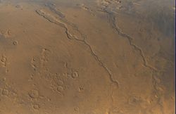
Niger Vallis is the middle of the three channels pictured, joining Dao Vallis in the upper center of the image. The direction of water flow was toward the bottom of the image.Coordinates 35°24′S 267°48′W / 35.4°S 267.8°WCoordinates: 35°24′S 267°48′W / 35.4°S 267.8°W Length 333.0 km Naming River in Africa. Niger Vallis is a valley on Mars that appears to have been carved by water. It has been identified as an outflow channel.[1] It merges with Dao Vallis which runs southwestward into Hellas Planitia from the volcanic Hadriacus Mons.[2] Like Dao, it was formed around the Late Noachian and Early Hesperian Epochs.[2] It is named after the Niger River in Africa.
Ice-rich Mantle
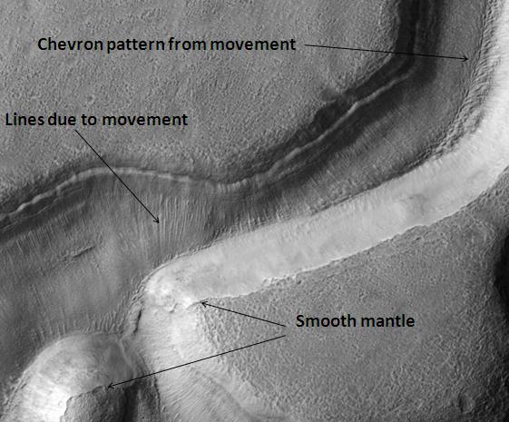
Much of the surface of Mars is covered by a thick smooth mantle that is thought to be a mixture of ice and dust.[3] This ice-rich mantle, a few yards thick, smoothes the land, but in places it has a bumpy texture, resembling the surface of a basketball. Because there are few craters on this mantle, the mantle is relatively young. An image below shows a good view of this smooth mantle around Niger Vallis, as observed with HiRISE.
Changes in Mars's orbit and tilt cause significant changes in the distribution of water ice from polar regions down to latitudes equivalent to Texas. During certain climate periods water vapor leaves polar ice and enters the atmosphere. The water comes back to ground at lower latitudes as deposits of frost or snow mixed generously with dust. The atmosphere of Mars contains a great deal of fine dust particles. Water vapor will condense on the particles, then fall down to the ground due to the additional weight of the water coating. When ice at the top of the mantling layer goes back into the atmosphere, it leaves behind dust, which insulating the remaining ice.[4]
-
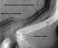
Niger Vallis with features typical of this latitude, as seen by HiRISE. Click on image to see chevron pattern and mantle.
Notes
- ^ Carr, M.H. (2006), The Surface of Mars. Cambridge Planetary Science Series, Cambridge University Press.
- ^ a b Crown, D. A.; Bleamaster, L. F.; Mest, S. C. (December 2003). "Geologic Evolution of Dao Vallis, Mars". American Geophysical Union, Fall Meeting 2003, abstract #P11B-1035. http://adsabs.harvard.edu/abs/2003AGUFM.P11B1035C. Retrieved 2006-10-15.
- ^ Head, J. et al. 2003. Recent ice ages on Mars. Nature:426. 797-802.
- ^ MLA NASA/Jet Propulsion Laboratory (2003, December 18). Mars May Be Emerging From An Ice Age. ScienceDaily. Retrieved February 19, 2009, from http://www.sciencedaily.com /releases/2003/12/031218075443.htmAds by GoogleAdvertise
External links
Categories:- Hellas quadrangle
- Valleys and canyons on Mars
- Mars stubs
- Astrogeology stubs
-

Wikimedia Foundation. 2010.