- Anadyr (town)
-
For other uses, see Anadyr (disambiguation).
Anadyr (English)
Анадырь (Russian)- Town[1] - 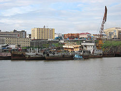
View of Anadyr from the harbour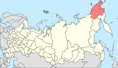
Location of Chukotka Autonomous Okrug in Russia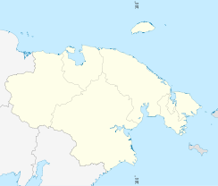
 Anadyr
Coordinates: 64°44′N 177°31′E / 64.733°N 177.517°ECoordinates: 64°44′N 177°31′E / 64.733°N 177.517°E 

Coat of arms Flag Administrative status Country Russia Federal subject Chukotka Autonomous Okrug[2] Administrative center of Chukotka AO[2] Municipal status Urban okrug Anadyr Urban Okrug[citation needed] Head of Administration[citation needed] Andrey Shchegolkov[3] Statistics Population (2002 Census) 11,038 inhabitants[1] Population (2010 est.) 11,777 inhabitants[citation needed] Time zone MAGST (UTC+12:00)[4] Founded 1889[2] Town status since 1965[2] Postal code(s) 689000[5] Dialing code(s) +7 42722[2] Official website Anadyr (Russian: Ана́дырь, Chukchi: Кагыргын, Kagyrgyn) is a port town and the administrative centre of Chukotka Autonomous Okrug, the extreme north-eastern region of Russia. It is at the mouth of the Anadyr River, on the tip of the southern promontory that sticks out into Anadyrskiy Liman. At 177°30′E, Anadyr is the easternmost town in Russia (more easterly locations, such as Provideniya and Uelen do not have town status by the Russian definition). It was founded on July 21, 1889 as Novo-Mariinsk, and renamed on August 5, 1923 following the Kamchatka Revkom. Town status was granted on January 12, 1965.
Contents
History
Although the town itself has only been in existence for just over a century, the origins of the name Anadyr are much older. The name initially derives from the Yukaghir word "any-an" meaning "river". When Semyon Dezhnev met Yukaghir peoples in the area and the indigenous name was corrupted to form "Onandyr", later Anadyrsk, the name of the ostrog (fort) upstream of the present-day settlement, from which the current name is derived.[2]
Pyotr Baranov (brother of Alexander Andreyevich Baranov) established a trading post near the present town site in the early 19th century; Chukchi settlement around it formed the village of Vyon in 1830.[2]
The present settlement was founded by L. F. Grinevetsky, who sailed into the Anadyrskiy Liman on July 9, 1889. The town's first building was completed 12 days later and as it was the name-day of Tsarista Maria Feodorovna the town was named Mariinsk. Since this was not the first time that a town had been named Mariinsk in Russia, the name was swiftly changed to Novo-Mariinsk.[2]
The presence of Communism was not initially welcomed by the merchants of the town. The first Revkom was founded on January 16, 1919 and barely lasted 2 weeks before its members were thrown out of the town and summarily executed. However, the merchants of the town fared worse 18 months later when the Bolsheviks returned and began to reorganise urban life.[2]
The town originally also incorporated other urban-type settlements such as Ugolnye Kopi, Shakhtyorsky and villages (selos) such as Tavaivaam, but these are independent settlements.
Although Anadyr is the largest town in the whole of Chukotka Autonomous Okrug, and the Administrative centre of the Okrug, it is not the Administrative centre of Anadyrsky District, which is in Ugolnye Kopi.
Demographics
1926[6] 1939[7] 1959[8] 1970[9] 1979[10] 1989[11] 2002[12] 2010[13] 224 3344 5859 7703 12241 17094 11038 11777 Transportation
Anadyr is an important sea port on the Gulf of Anadyr of the Bering Sea and is connected to almost all big Russian Far Eastern sea ports. The Anadyr Ugolny Airport serves major and minor cities in the Russian Far East with connections to Khabarovsk, Vladivostok and Moscow, and Bering Air charter flights to Nome, Alaska. The airport is on the other side of the Anadyrskiy Liman and between January and May transportation from the airport to Anadyr is by ice road.[2]
Climate
Anadyr experiences a subarctic climate (Köppen climate classification Dfc). The weather in Anadyr is extremely changeable, with heavy storms often being brought in from the Anadyrskiy Liman and the Bering Sea. This coupled with strong southerly winds in the autumn often brings flooding to the area.
Climate data for Anadyr Month Jan Feb Mar Apr May Jun Jul Aug Sep Oct Nov Dec Year Record high °C (°F) 5.8
(42.4)2.7
(36.9)3.0
(37.4)7.1
(44.8)13.3
(55.9)26.5
(79.7)30.0
(86.0)26.6
(79.9)17.7
(63.9)15.6
(60.1)4.6
(40.3)4.3
(39.7)30.0
(86.0)Average high °C (°F) −17.4
(0.7)−18.1
(−0.6)−16.4
(2.5)−9.5
(14.9)0.6
(33.1)9.9
(49.8)14.9
(58.8)13.4
(56.1)7.1
(44.8)−2.7
(27.1)−10.9
(12.4)−16.8
(1.8)−3.7 Average low °C (°F) −24.9
(−12.8)−25.4
(−13.7)−23.8
(−10.8)−17
(1)−5.4
(22.3)2.5
(36.5)8.1
(46.6)7.2
(45.0)1.5
(34.7)−8
(18)−17.5
(0.5)−24.1
(−11.4)−10.5 Record low °C (°F) −46.8
(−52.2)−44.7
(−48.5)−42.1
(−43.8)−39.6
(−39.3)−28.2
(−18.8)−7.6
(18.3)−1.2
(29.8)−4.3
(24.3)−11.8
(10.8)−28.2
(−18.8)−38.8
(−37.8)−45.2
(−49.4)−46.8
(−52.2)Precipitation mm (inches) 40
(1.57)29
(1.14)23
(0.91)18
(0.71)13
(0.51)21
(0.83)36
(1.42)43
(1.69)30
(1.18)22
(0.87)31
(1.22)40
(1.57)346
(13.62)Sunshine hours 27.9 101.7 198.4 249.0 244.9 279.0 257.3 186.0 138.0 105.4 48.0 12.4 1,848 Source no. 1: Погода и Климат[14] Source no. 2: HKO[15] Famous people
- Valery Ivanovich Tokarev, cosmonaut, was raised in Anadyr
- Roman Abramovich, oil oligarch and the former governor of Chukotka, invested much of his wealth in the town's infrastructure
Sister city
 Bethel, Alaska (USA).[16]
Gallery
-

View from Anadyr Airport
-

Anadyr Child Creativity Palace
-

Anadyr Market
-
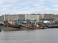
View from Anadyr harbour
See also
- List of inhabited localities in Anadyrsky District
- Extreme points of Russia
References
Notes
- ^ a b Федеральная служба государственной статистики (Federal State Statistics Service) (2004-05-21). "Численность населения России, субъектов Российской Федерации в составе федеральных округов, районов, городских поселений, сельских населённых пунктов – районных центров и сельских населённых пунктов с населением 3 тысячи и более человек (Population of Russia, its federal districts, federal subjects, districts, urban localities, rural localities—administrative centers, and rural localities with population of over 3,000)" (in Russian). Всероссийская перепись населения 2002 года (All-Russia Population Census of 2002). Federal State Statistics Service. http://www.perepis2002.ru/ct/doc/1_TOM_01_04.xls. Retrieved 2010-03-23.
- ^ a b c d e f g h i j Petit Fute, Chukotka, p.77ff
- ^ Anadyr - Official Chukotka Website
- ^ Правительство Российской Федерации. Постановление №725 от 31 августа 2011 г. «О составе территорий, образующих каждую часовую зону, и порядке исчисления времени в часовых зонах, а также о признании утратившими силу отдельных Постановлений Правительства Российской Федерации». Вступил в силу по истечении 7 дней после дня официального опубликования. Опубликован: "Российская Газета", №197, 6 сентября 2011 г. (Government of the Russian Federation. Resolution #725 of August 31, 2011 On the Composition of the Territories Included into Each Time Zone and on the Procedures of Timekeeping in the Time Zones, as Well as on Abrogation of Several Resolutions of the Government of the Russian Federation. Effective as of after 7 days following the day of the official publication).
- ^ Red Cross Chukotka
- ^ Список населённых мест Дальневосточного края. По материалам Всесоюзной переписи населения 17 декабря 1926 года и Приполярной переписи 1926—27 года. — Хабаровск; Благовещенск, 1929.
- ^ РГАЭ, ф. 1562, оп. 336, д. 1470, л. 20.
- ^ Перепись населения СССР 1959 года
- ^ Перепись населения СССР 1970 года
- ^ Перепись населения СССР 1979 года
- ^ Всесоюзная перепись населения 1989 г. Численность городского населения РСФСР, ее территориальных единиц, городских поселений и городских районов по полу
- ^ Численность населения России, федеральных округов, субъектов Российской Федерации, районов, городских поселений, сельских населенных пунктов — райцентров и сельских населенных пунктов с населением 3 тысячи и более человек
- ^ Численность постоянного населения Российской Федерации по городам, поселкам городского типа и районам на 1 января 2010 г.
- ^ "Погода и Климат - КЛИМАТ АНАДЫРЯ" (in ru). http://pogoda.ru.net/climate/25563.htm. Retrieved Sept 15 2009.
- ^ "Climatological Information for Anadyr', Russia" (in en). http://www.hko.gov.hk/wxinfo/climat/world/eng/europe/russia/anadyr_e.htm. Retrieved August 31, 2011.
- ^ Bethel Government Office Website
External links
- Official website of Anadyr
- Flickr photos tagged anadyr
- Clipper Ship Razboinik which helped found Novo Mariinsk
- Anadyr Photo Gallery
- Panorama of Anadyr
- More photos of Anadyr
Administrative divisions of Chukotka Autonomous Okrug Administrative center: AnadyrCities and towns 
Urban-type settlements Aliskerovo · Baranikha · Beringovsky · Bystry · Dalny · Egvekinot · Komsomolsky · Krasnoarmeysky · Leningradsky · Mys Shmidta · Otrozhny · Provideniya · Shakhtyorsky · Ugolnye Kopi · Valkumey · Vesenny · Vstrechny · YuzhnyAdministrative districts (raions) Categories:- Port cities and towns in Russia
- Cities and towns in Chukotka Autonomous Okrug
- Ports and harbours of the Russian Pacific Coast
- Anadyr (town)


Wikimedia Foundation. 2010.