- Cadair Idris
-
Cadair Idris 
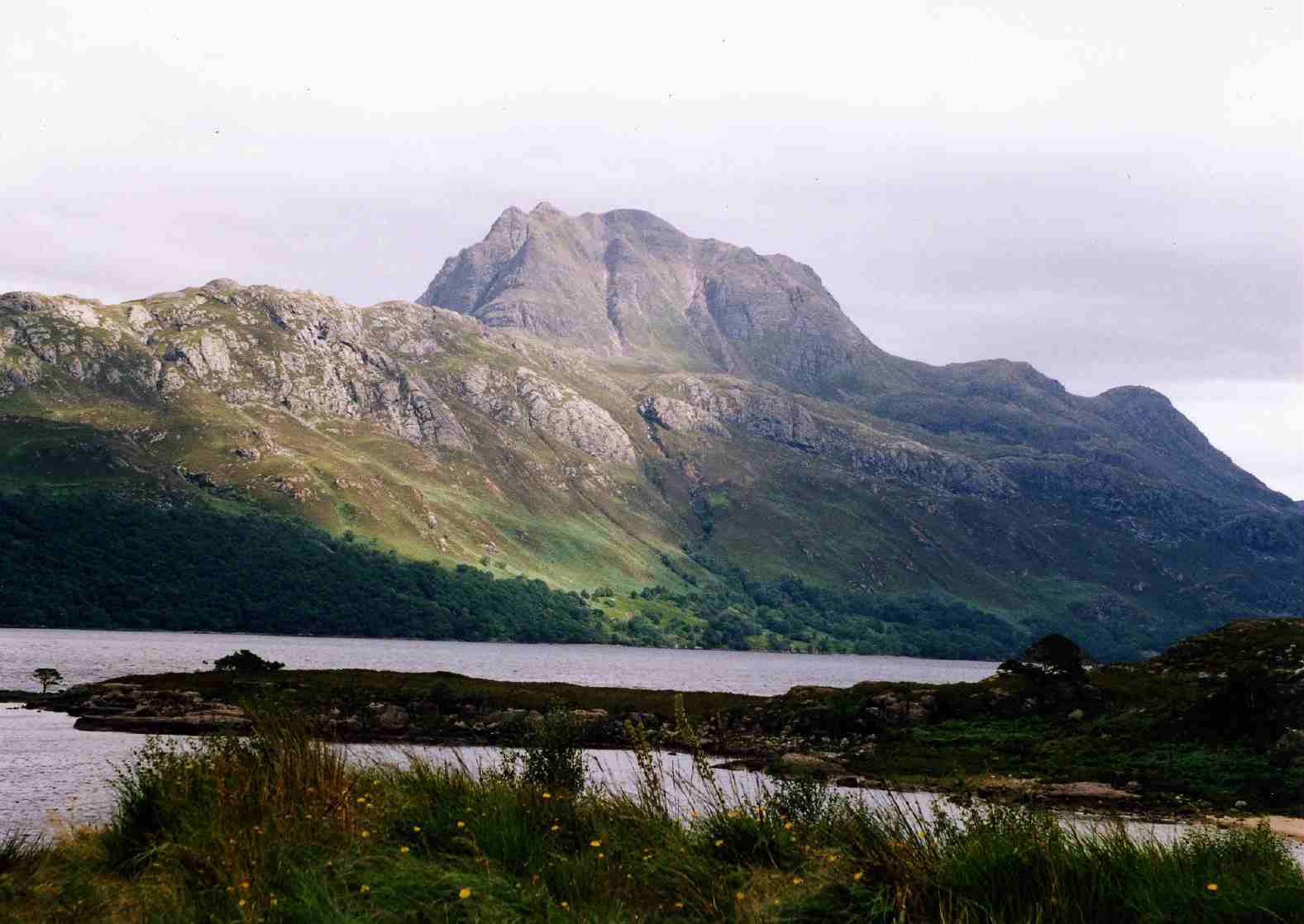
Llyn Cau within the steep rock walls of Craig Cau. Penygadair, the summit of the mountain, is to the rightElevation 893 m (2,930 ft) Prominence 608 m (1,995 ft) Parent peak Aran Fawddwy Listing Marilyn, Hewitt, Nuttall Translation Chair of Idris (Welsh) Pronunciation Welsh: [ˈkadair ˈɪdrɪs] Location Location Gwynedd,  Wales
WalesRange Snowdonia Topo map OS Landranger 124, Explorer OL23 OS grid SH711130 Climbing Easiest route Hike Cadair Idris or Cader Idris is a mountain in Gwynedd, Wales that lies at the southern end of the Snowdonia National Park. The peak, which is one of the most popular in Wales for walkers and hikers, [1] is composed largely of Ordovician igneous rocks, with classic glacial erosion features such as cwms, moraines, striated rocks, and roches moutonnées.
Contents
Names
The name of the mountain has several theories. The most well known is that Cadair Idris (English: the chair of Idris) is in reference to a giant of Welsh mythology who was said to have used Llyn Cau as an enormous armchair to gaze at the stars. [2] The spelling Cader Idris is also found in both Welsh and English, as reflected in the local name of the local secondary school, Ysgol y Gader (never Ysgol y Gadair). [2] Although cader is not incorrect, Cadair Idris is the form used on current maps in reflection of modern standardised Welsh spelling.
An alternative theory is that a 7th-century Meirionnydd prince Idris ap Gwyddno (or Gweiddno) won a battle against the Irish on the mountain. [2] Cadr is the Welsh word for stronghold which sounds similar to the Welsh word for chair cadair. Cad is also a prefix that relates to battle. Cadr Idris may have been the stronghold of Idris ap Gwyddno.[3]
The entire mountain is called Cader Idris but its summit is known as Penygader (English: top of the chair).
Ascent


The Northern face of Cadair Idris viewed from Garth Gell (Bontddu) Listed summits of Cadair Idris Name Grid ref Height Status Mynydd Moel SH727136 863 metres (2,831 ft) Hewitt
NuttallCyfrwy SH703133 811 metres (2,661 ft) Hewitt
NuttallCraig Cwm Amarch SH710121 791 metres (2,595 ft) Hewitt
NuttallGau Graig SH744141 683 metres (2,241 ft) Hewitt
NuttallTyrrau Mawr SH677135 661 metres (2,169 ft) Hewitt
NuttallCraig-y-llyn SH677135 622 metres (2,041 ft) Hewitt
NuttallThere are three main trails that lead to the top of Cadair Idris. The summit, which is covered in scree, is marked by a trig point. There is also a low-standing stone shelter with a roof.
Pony Path
This route, which begins in the north from either Dolgellau or the Mawddach estuary, is the easiest but the longest of the main trails. Its length from the mountain's base is 5 kilometres (3.1 mi) with a 600 metres (2,000 ft) climb.
Fox's Path
This is the most direct way to the summit as the trail leads straight up the northern face. The 3.8 kilometres (2.4 mi) ascent involves a climb up a 310 metres (1,020 ft) cliff-scree face. However this part of the Fox's Path has been heavily eroded in recent years making the descent dangerous.
Minffordd Path
This route starts on the southern side of the mountain near the glacial Tal-y-llyn Lake. Hikers using this ascent climb past Llyn Cau and along the rim of Craig Cau (rockwall) to Penygadair. Its length is 4.4 kilometres (2.7 mi) and involves two climbs of over 300 metres (980 ft).
Geology

The crater-like shape of Llyn Cau has given rise to the occasional mistaken claim that Cadair Idris is an extinct volcano. This theory was discounted as early as 1872, when Charles Kingsley commented in his book Town Geology [4]:
“ I have been told, for instance, that that wonderful little blue Glas Llyn,[5] under the highest cliff of Snowdon, is the old crater of the mountain; and I have heard people insist that a similar lake, of almost equal grandeur, in the south side of Cader Idris, is a crater likewise. But the fact is not so. ” The natural bowl-shaped depression was formed by a cirque glacier during the last ice age when snow and ice accumulated in the corries due to avalanches on higher slopes. In these depressions, snow persisted through summer months, and becomes glacial ice. The cirque was up to a square kilometre in size surrounded on three sides by steep cliffs. The highest cliff was the headwall. The fourth side was the "lip" from which the glacier flowed away from the cirque. Over thousands of years ice flowed out through the bowl's opening carving the chair of Caldair Idris.
As the glacier eroded the lip down to the bedrock, there are several tear-drop shaped hills above the edge of Lyn Cau. These geologically-important rocky outcrops are called roche moutonnée (English: sheep-like rock) and were formed from the abrasive action of the ice.
Much of the area around Cadair Idris was designated a National Nature Reserve in 1957, and is home to arctic-alpine plants such as purple saxifrage and dwarf willow .[6]
Myths and legends
 Looking at Penygadair (right) from the Pony Path in January 2005. The steep scree route of the Fox's Path is highlighted in sunlight (centre).
There are numerous legends about Cadair Idris. Some nearby lakes are supposed to be bottomless, and anyone who sleeps on its slopes alone, will supposedly awaken either a madman or a poet. This tradition (of sleeping on the summit of the Mountain) apparently stems from bardic traditions, where bards would sleep on the mountain in hope of inspiration.[7]
The mountain's name refers to the mythological giant Idris (Idris Gawr) who was said to have been skilled in poetry, astronomy and philosophy.[7] The name has sometimes been mistranslated by some popular authors as Arthur's Seat, in reference to King Arthur (and to the hill of the same name in Edinburgh), an idea used by author Susan Cooper in her book The Grey King. However, this is a modern invention and there is no etymological or traditional connection between Idris and Arthur.
In Welsh mythology, Cadair Idris is also said to be one of the hunting grounds of Gwyn ap Nudd and his Cŵn Annwn. The howling of these huge dogs foretold death to anyone who heard them, the pack sweeping up that person's soul and herding it into the underworld.
References
- ^ "Cadair Idris". SnowdoniaGuide.com. http://snowdoniaguide.com/cader_idris.html. Retrieved October 31, 2006.
- ^ a b c Koch, John T. (2006). Celtic culture: a historical encyclopedia, Volumes 1-5. ABC-CLIO. p. 312. ISBN 9781851094400.
- ^ Bowen, Emrys George; J. Beverley Smith; Merioneth Historical and Record Society; Llinos Beverley Smith (Eds) (2001). History of Merioneth Volume II: The Middle Ages. Cardiff: University of Wales Press. ISBN 0-7083-1709-X.
- ^
- ^ "Glas Llyn" here refers to Glaslyn.
- ^ "Cadair Idris National Nature Reserve". United Nations Environment Programme World Conservation Monitoring Centre. http://www.unep-wcmc.org/sites/pa/0654v.htm. Retrieved October 31, 2006.
- ^ a b Celtic Mythology. Geddes and Grosset. 1999. p. 480 Pages. ISBN 1-85534-299-5.
External links
- Computer generated summit panoramas North South index
- A description of and guide to climbing Cadair Idris from h2g2
- www.geograph.co.uk : photos of and from Cadair Idris
Coordinates: 52°41′59″N 3°54′31″W / 52.699828°N 3.908693°W
Categories:- Marilyns of Wales
- Hewitts of Wales
- Mountains and hills of Snowdonia
- National Nature Reserves in Wales
- Nuttalls
- Sites of Special Scientific Interest in East Gwynedd
- Landmarks in Wales
- Mountains and hills of mid Wales
- Mountains and hills of north Wales
- Geography of Gwynedd


Wikimedia Foundation. 2010.