- Coalman Glacier
-
This article is about the glacier on Mount Hood. For the glacier on Mount Baker, see Coleman Glacier (Washington).
Coalman Glacier Type Mountain glacier Location Clackamas / Hood River counties, Oregon, USA Coordinates 45°22′20″N 121°41′50″W / 45.37222°N 121.69722°WCoordinates: 45°22′20″N 121°41′50″W / 45.37222°N 121.69722°W Area 900,000 ft² Terminus Talus 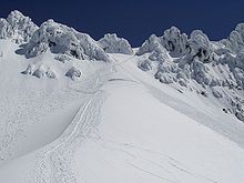 Summer Solstice on the Hogsback looking up toward Pearly Gates; the Bergschrund is at center.
The Coalman Glacier (also Coleman Glacier) is a glacier located on the upper slopes of Mount Hood in the U.S. state of Oregon.[1] It is the mountain's highest glacier ranging from about 10,500 to 11,200 ft (3,200 to 3,415 m), located within the crater rim, southwest of the peak. It was named for Elija Coalman[2] (variously spelled Elijah Coleman[3]), an early mountain guide who climbed Mount Hood 586 times.[4]
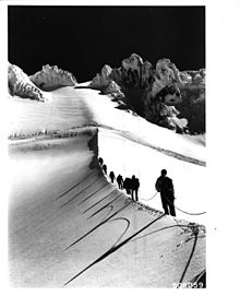
Coalman is the second most frequently visited glacier on the mountain because it is part of the popular South Climbing route from Timberline Lodge. It lies entirely within Mount Hood Wilderness. The most well known feature of Coalman is the Hogsback: a snow ridge running southwest to northeast from Crater Rock toward the summit ridge. The Bergschrund is another widely known feature where the glacier pulls away from the headwall leaving a large crevasse. In 2007, it had become large enough to cause most climbers to use another route.[5]
The glacier is a remnant of the massive glaciers that formed during the last ice age. It is historically known to change configuration dramatically, at times a gradual, smooth surface to Hot Rocks; at other times the same place has a 40 ft (12 m) ice cliff.[2]
The glacier flows southwest, and is bounded on the north and east by the summit, on the northwest by the rocky crater wall known as Castle Crags (also Hawkins Cliffs), on the west by Hot Rocks, and on southeast by the back side of Steel Cliff.
See also
References
- ^ "Coalman Glacier, USGS Mount Hood South (OR) Topo Map". TopoQuest. http://www.topoquest.com/map.php?lat=45.37281&lon=-121.69880&datum=nad27&zoom=4. Retrieved 2008-05-16.
- ^ a b Jack Grauer (July 1975). Mount Hood: A Complete History. self published. pp. 291. ISBN 0-930584-01-5.
- ^ Thomas P. Deering, Jr. (1986, updated July 2, 2004). "Mountain Architecture: An Alternative Design Proposal for the Wy'East Day Lodge, Mount Hood Oregon". http://www.seanet.com/~tdeering/thesis/ch-4d.htm. Retrieved 2007-08-16.
- ^ "1910: Famous Early Mount Hood Climber". Gorge.net. archive.org snapshot July 7, 2007. Archived from the original on 2007-07-07. http://web.archive.org/web/20070707230255/http://www.gorge.net/community/hscascad.htm. Retrieved 2007-08-16. citing "Legacy". Hood River News.
- ^ Previous noticed posted at "Mount Hood Climbing Report, May 17th". United States Forest Service. http://www.fs.fed.us/r6/mthood/recreation/climbing/conditions.shtml. Retrieved 2007-05-17.
Glaciers of Mount Hood - Coe Glacier
- Coalman Glacier
- Eliot Glacier
- Glisan Glacier
- Ladd Glacier
- Langille Glacier
- Newton-Clark Glacier
- Palmer Glacier
- Reid Glacier
- Sandy Glacier
- White River Glacier
- Zigzag Glacier
Categories:- Glaciers of Oregon
- Mount Hood
- Landforms of Clackamas County, Oregon
- Landforms of Hood River County, Oregon
- Mount Hood National Forest
- Clackamas County, Oregon geography stubs
- Oregon geography stubs


Wikimedia Foundation. 2010.