- Oddington, Oxfordshire
-
Coordinates: 51°49′52″N 1°11′53″W / 51.831°N 1.198°W
Oddington 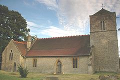
St Andrew's parish church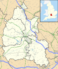
 Oddington
Oddington shown within OxfordshirePopulation 133 (2001 census)[1] OS grid reference SP5514 Parish Oddington District Cherwell Shire county Oxfordshire Region South East Country England Sovereign state United Kingdom Post town Kidlington Postcode district OX5 Dialling code 01865 Police Thames Valley Fire Oxfordshire Ambulance South Central EU Parliament South East England UK Parliament Banbury List of places: UK • England • Oxfordshire Oddington is a village and civil parish about 5 miles (8.0 km) south of Bicester in Oxfordshire, England. The village is close to the River Ray on the northern edge of Otmoor.
Contents
History
The toponym is derived from the Old English for "Ot(t)a's Hill", possibly after the same person who gave his name to Otmoor.[2]
Parish church
A mention of Oddington in a Papal bull written in AD 1146 suggests that the village had a parish church by the middle of the 12th century.[3] The present Church of England parish church of Saint Andrew was built at the end of the 13th century and beginning of the 14th century. The buttresses of the nave are late 13th century, and the font is probably also from that century. Some features of the chancel are early 14th century, but in 1821 the chancel was demolished and rebuilt.
Between 1884 and 1886 the church was heavily restored by the architect E.G. Bruton. He rebuilt the bell tower and the north wall of the chancel, and added the vestry, north aisle and several windows. At the west end of the church is a large pietà decorated with Māori totems, created as a memorial to Māori servicemen killed in the First World War.[3]
The tower has three bells. The treble was cast in 1609 but the bellfounder has not been identified.[4] James Keene of Woodstock[5] cast the tenor in 1626.[4] Thomas I Mears of the Whitechapel Bell Foundry[5] cast the youngest of the three bells in 1804.[4] For technical reasons the bells are currently unringable. There is also a Sanctus bell, cast by an unknown founder in about 1614.[4] Unfortunately this bell is cracked.[6]
Gilbert Sheldon held the living of the parish[3] from 1636. Sheldon already held the living of Hackney, received that of Ickford, Buckinghamshire at about the same time as that of Oddington, and at some time also the living of Newington, Oxfordshire. After the Restoration of the Monarchy, Sheldon was consecrated Archbishop of Canterbury in 1663.
The Syriac scholar William Cureton was curate of Oddington for a time in the 19th century.[3] St. Andrew's is now part of the Church of England Benefice of the Ray Valley.[7]
Railway
The Buckinghamshire Railway between Bletchley and Oxford, completed in 1851, passes through the parish. The Buckinghamshire Railway was taken over by the London and North Western Railway in 1879, which opened Oddington Halt at Oddington Crossing, 1 mile (1.6 km) northwest of the village in 1905. The 1923 Grouping made the L&NWR part of the new London, Midland and Scottish Railway, which closed Oddington Halt in 1926. The part of the line between Oxford and Bicester is now the Bicester Link. The line's nearest station to Oddington is now Islip, 1.5 miles (2.4 km) away.
References
- ^ "Area: Oddington CP (Parish): Parish Headcounts". Neighbourhood Statistics. Office for National Statistics. http://neighbourhood.statistics.gov.uk/dissemination/LeadTableView.do?a=7&b=798592&c=Oddington&d=16&e=15&g=480236&i=1001x1003x1004&o=1&m=0&r=1&s=1268057615026&enc=1&dsFamilyId=779. Retrieved 8 March 2010.
- ^ Lobel, 1959, page 276
- ^ a b c d Lobel, 1959, pages 276-285
- ^ a b c d "Oddington S Andrew". Dove's Guide for Church Bell Ringers. http://dove.cccbr.org.uk/detail.php?searchString=Oddington&Submit=+Go+&DoveID=ODDINGTONO. Retrieved 10 March 2011.
- ^ a b "Bell Founders". Dove's Guide for Church Bell Ringers. http://dove.cccbr.org.uk/founders.php. Retrieved 10 March 2011.
- ^ Oxford Diocesan Guild of Church Bell Ringers, Bicester Branch
- ^ A Church Near You: Saint Andrew, Oddington
Sources
- Lobel, Mary D., ed (1959). A History of the County of Oxford: Volume 6. Victoria County History. pp. 276–285. http://www.british-history.ac.uk/report.aspx?compid=63747.
- Sherwood, Jennifer; Pevsner, Nikolaus (1974). Oxfordshire. The Buildings of England. Harmondsworth: Penguin Books. p. 730. ISBN 0 14 071045 0.
External links
 Media related to Oddington, Oxfordshire at Wikimedia CommonsCategories:
- Villages in Oxfordshire
- Civil parishes in Oxfordshire


Wikimedia Foundation. 2010.