- Cooktown, Queensland
-
Cooktown
Queensland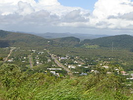
View of Cooktown from Grassy Hill
 Cooktown
Population: 1,336 (2006 Census)[1] Established: 1873 Postcode: 4895 Coordinates: 15°28′S 145°17′E / 15.467°S 145.283°ECoordinates: 15°28′S 145°17′E / 15.467°S 145.283°E Elevation: 6.0 m (20 ft) Location: - 2034 km (1,264 mi) from Brisbane
- 326 km (203 mi) from Cairns
- 267 km (166 mi) from Port Douglas
LGA: Cook State District: Cook Federal Division: Leichhardt Mean max temp Mean min temp Annual rainfall 31.5 °C
89 °F24.3 °C
76 °F1,809.7 mm
71.2 inCooktown is a small town located at the mouth of the Endeavour River, on Cape York Peninsula in Far North Queensland where James Cook beached his ship, the Endeavour, for repairs in 1770. At the 2006 census, Cooktown had a population of 1,336.[1] Both the town and Mount Cook (431 metres or 1,415 feet) which rises up behind the town were named after James Cook.[2]
It is the northernmost town on the east coast of Australia and was founded on 25 October 1873 as a supply port for the goldfields along the Palmer River.[3][4] It was called 'Cook's Town' until 1st June 1874.[5]
Contents
History
Aboriginal history
In the local Guugu Yimithirr language the name for the region is, Gan.gaarr Aboriginal pronunciation: [ɡ̊anˈɡaːr], which means "(Place of the) Rock Crystals." Quartz crystals were used in various Aboriginal ceremonies across the continent and are found in the vicinity; they were traded from the Cooktown region at least as far as Mossman, about 300 km south of Cooktown, and possibly much further.[citation needed]
Cook's Arrival
The site of modern Cooktown was the meeting place of two vastly different cultures when, in June 1770, the local Aboriginal Guugu Yimithirr tribe cautiously watched the crippled sailing ship – His Majesty's Bark Endeavour – limp up the coast seeking a safe harbour after sustaining serious damage to its wooden hull on the Endeavour Reef, south of Cooktown. The Guugu Yimithirr people saw the Endeavour beach in the calm waters near the mouth of their river, which they called "Wahalumbaal".
The captain of the Endeavour, Lieutenant James Cook, wrote: “. . . it was happy for us that a place of refuge was at hand; for we soon found that the ship would not work, and it is remarkable that in the whole course of our voyage we had seen no place that our present circumstances could have afforded us the same relief".
 Endeavour replica sailing into Cooktown's harbour near the mouth of the Endeavour River where the original Endeavour was beached for 7 weeks in 1770.
The British crew spent seven weeks on the site of present-day Cooktown, repairing their ship, replenishing food and water supplies, and caring for their sick. The extraordinary scientist, Joseph Banks, and Swedish naturalist Daniel Solander, who accompanied Cook on the expedition, collected, preserved and documented over 200 new species of plants. The young artist Sydney Parkinson illustrating the specimens and he was the first British artist to portray Aboriginal people from direct observation.
After some weeks, Joseph Banks met and spoke with the local people, recording about 50 Guugu Yimithirr words, including the name of the intriguing animal the natives called gangurru (which he transcribed as "Kangaru"). Cook recorded the local name as "Kangooroo, or Kanguru".[6]
The first recorded sighting of kangaroos by Europeans was on Grassy Hill, which rises above the place where the ship was beached. Cook climbed this hill to work out a safe passage for the Endeavour to sail through the surrounding reefs, after it was repaired.
Cook named the river the "Endeavour" after his ship, and, as they sailed north, he hoisted the flag known as the 'Queen Anne Jack' and claimed possession of the whole eastern coast of Australia for Britain. He named Cape York Peninsula after the then Duke of York ("The Grand Old Duke of York").
- "In 1886 the people of Cooktown were anxious to recover the brass guns of the Endeavour which were thrown overboard, in order to place them as a memento in their town; but they could not be found, which is not altogether surprising."[7]
King's Expedition
The next recorded European expedition to the area was nearly 50 years later, when another botanist, Allan Cunningham, accompanying Captain Phillip Parker King, visited the remarkable region in 1819-20. He also collected numerous botanical specimens for the British Museum and Kew Gardens.
Gold Rush
In 1872, William Hann discovered gold in the Palmer River, southwest of Cooktown. His findings were reported to James Venture Mulligan who led an expedition to the Palmer River in 1873. Mulligan's expedition found quantities of alluvial gold and thus began the gold rush that was to bring prospectors to the Endeavour River from all over the world.
The Queensland government responded quickly to Mulligan's reports, and soon a party was dispatched to advise whether the Endeavour River would be a suitable site for a port. Shortly after, a new township was established at the site of the present town, on the southern bank of the river.
The Palmer goldfields and its centre, Maytown, were growing quickly. The recorded output of gold from 1873 to 1890 was over half a million ounces (more than 15,500 kg). Cooktown was the port through which this gold was exported and supplies for the goldfields brought in. Word of the gold quickly spread, and Cooktown was soon thriving, as prospectors arrived from around the world.
Population estimates vary widely, but there were probably around 7,000 people in the area and about 4,000 permanent residents in the town by 1880. At that time, Cooktown boasted a large number of hotels and guest houses. There were 47 licensed pubs within the town boundaries in 1874 although this number had dropped to 27 by the beginning of 1880. There were also a number of illegal grog shops and several brothels. There were bakeries, a brewery and a soft drinks factory, dressmakers and milliners, a brickworks, a cabinetmaker, and two newspapers.
The port of Cooktown served the nearby goldfields and, during the goldrush of the 1870s, a Chinese community many thousands strong grew up in the goldfields and in the town itself. The Chinese played an important role in the early days of Cooktown. They came originally as prospectors, but many established market gardens, supplying the town and the goldfields with fruit, vegetables and rice, while others opened shops.
However, largely through cultural misunderstandings, conflict broke out between the Aboriginal people and the new settlers, and the diggers. The Cooktown Herald, 8 December 1875, reported: “The natives wholly ignorant of the terrible firepower of fire-arms, and confiding in their numbers, showed a ferocity and daring wholly unexpected and unsurpassed. Grasping the very muzzles of the rifles they attempted to wrest them from the hands of the whites, standing to be shot down, rather than yield an inch....” It was an unequal struggle. Whole tribes were wiped out as European settlement spread over Cape York Peninsula.
 A visit of Chinese Commissioners to Cooktown in 1887.
In 1887, a Chinese Investigation Commission to South-East Asia arrived in Cooktown from Canton to investigate the social conditions of Chinese living in the colonies and to establish consulates in them. The visit went well, General Wong Yung Ho was pleased with what they had found, and cheers were exchanged between the Commission members and local residents as they left on August 7, 1887.[8]
Transport was an ongoing problem for the new settlers. Getting supplies and people to the goldfields often took three weeks. After every wet season the tracks and bridges had to be remade. A railway line from Cooktown to Maytown, was planned, but it took five years to get the 67 miles (108 km) to Laura – and that is where it stopped.[9] By that time the gold was petering out, so the Queensland Government refused further funding for the venture.
In spite of this, the train proved to be a lifeline for the Peninsula people connecting the hinterland to Cooktown, from where one could catch a boat to Cairns and other southern ports. The line was closed in 1961 after the Peninsula Development Road was built connecting Cooktown and other Peninsula communities with Cairns and the Atherton Tableland to the south.
 Locomotive at the Cooktown Railway Station, ca 1889
Cooktown's magnificent Botanic Garden of 62 hectares (154 acres) was established near the town in 1878. Much work was done in the early stages – with wells sunk, water reticulated, garden beds enclosed, stone-lined paths, stone-pitched pools and footbridges made, and lawns, trees and shrubs planted.
Although the gardens fell into disrepair, in recent years they have been expanded and are a popular destination for botanists and nature lovers. Most of the early stonework has been restored, and beautiful walking tracks lead the visitor through the Botanic Garden to the magnificent beaches at Finch Bay and Cherry Tree Bay.
In 1881, a bridge over the Endeavour River was completed, which opened up the richer pastoral lands of the Endeavour and McIvor River valleys. Tin was found in the Annan River area, south of Cooktown, in 1884.
 James Cook Museum
In 1886, Lutheran missionaries came to Cooktown to establish a secure place for the Aboriginal people who were living in abominable conditions on the edge of the town. Missions were established at Elim on the beach (later they moved inland to Hopevale), and Wujal Wujal, near the mouth of the Bloomfield River.
In 1893 the town was described as follows:
- "Cooktown, which now stands on the Endeavour River, is a thriving place, and the northernmost town on this coast. It has some 2000 inhabitants, and is the port for a gold mining district. A deeper channel has now been dredged over the bar that gave Cook so much trouble, but it is not a harbour that will admit large vessels."[7]
With the gold rush over, the number of people living in the area started dwindling. Two major fires struck Cooktown – in 1875 and, again, in 1919 when whole blocks of buildings in the main street were burned to the ground. A major cyclone in 1907 added to the destruction.
World War II
By 1940, little evidence of Cooktown or Maytown's interesting past remained. During the Second World War, Cooktown became an important base for the war effort. The civilian population of Cooktown was encouraged to evacuate in face of the Japanese advances and by 1942 the vast majority had left. The Aboriginal people of the Lutheran missions at Hope Vale and Bloomfield were forcibly removed - most being taken south to Woorabinda in May, 1942, while some of the elderly people were sent to Palm Island. The senior missionary, Pastor Schwartz (known as Muni to the local people), was arrested and placed in internment as he were suspected as being an enemy sympathiser. The Aboriginal people were not allowed to return to their homelands until 1949, well after the end of the war. Many Aboriginal people died when moved from their traditional lands, and many Aboriginal and white families never returned from their exile.[10][11]
Some 20,000 Australian and American troops were stationed in and around the town. The busy airfield played a key role in the crucial Battle of the Coral Sea when Japanese expansion towards the Australian mainland was finally halted. The last military unit, the 27th Operational Base Squadron of the RAAF, ceased operations in Cooktown in April 1946.[12]
Since World War II
In 1949, another cyclone devastated the town, and Cooktown's population declined further. With the closure of the rail link to Laura in 1961 and the "Peninsula Development Road" opened up to the south, the population declined to just a few hundred people before it gradually began to climb again.
There is an active Aboriginal Community Centre on the main street called Gungarde (from the original Guugu Yimithirr name for the region).
The "Milbi Wall" (or "Story Wall") [5] marks the place of the first encounter between the British seafarers and the local Aborigines. The Milbi Wall tells the story of Cooktown and the Endeavour River from the perspective of the Aboriginal people, and is an outstanding monument to reconciliation.
Cooktown has recently grown in importance again and has become a popular tourist destination. The paving of the Mulligan Highway now provides all-weather access by road for the first time. There are two flights a day connecting Cooktown with Cairns. The town now has good communications, more services, better roads, and offers residents a relaxed and healthy lifestyle.
About 2,000 people live in the town itself while about another 4,000 in the region use it as a service centre. Visitors enjoy the delightful tropical environment, the historical connections, and use it as an access point to the Great Barrier Reef, the Lakefield National Park, and for fishing.
Cooktown is of particular interest to botanists since the time of James Cook's visit when extensive collections and illustrations were made of local plants. It is situated at the junction of several vegetation zones including tropical rainforest, sclerophyll forests, sandy dunes and lagoons. Vera Scarth-Johnson, a local resident, gave a priceless collection of her botanical illustrations to the people of Cooktown, which are now housed in a dedicated gallery at Nature's PowerHouse situated in the Botanic Gardens, and features displays of local flora and fauna.
Cooktown is a service centre for the district including the Aboriginal communities of Hopevale, 47 km to the northwest, and Wujal Wujal, 72 km to the south.
Cooktown is the northern terminus of the Bicentennial Heritage Trail, which, at 5,330 km (3,310 mi), is the longest trail of its type in the world. The southern end of the trail is at Healesville, Victoria, a town 52 km north-east of Melbourne.
The rugged Mount Cook (231 metres or 758 ft), named on 27 June 1818 by Phillip Parker King,[13] forms a backdrop to the town and is now part of the Mount Cook National Park.[14]
Cooktown gets regular strong trade winds over the dry season months of May through to October that provides good conditions for kitesurfing and windsurfing at the beach near the Annan River mouth.[15]
 Panorama from Grassy Hill, Cooktown, 2007
Flora and fauna
 The Mystery Orchid, Cooktownia robertsii, discovered and illustrated by Lewis Roberts (naturalist), and named after both him and Cooktown
Because the area around Cooktown is unusually rich in biodiversity, being close to three major ecozones, it contains a large proportion of the 3,000 plant species and the more than 500 terrestrial vertebrates recorded for Cape York Peninsula.[16] The region contains many rare or unusual species which are of great interst to botanists and zoologists.
When Lt. James Cook beached his ship, HMB Endeavour, at the mouth of the Endeavour River in 1770, Joseph Banks, Daniel Solander, and Sydney Parkinson made good use of the enforced 7-week stay to make and illustrate an extensive collection of the plants of the area, where they collected the vast majority of plants they brought back to England from Australia. The illustrations were later published as the famous Banks' Florilegium.
Since then, Cooktown and the lower Endeavour Valley area have become a major attraction to biologists and illustrators of plants and aniomals. Vera Scarth-Johnson (1912-1999), spent almost thirty years illustrating the flowering plants of the region and then gave her collection to the people of Cooktown. Following her wishes, a beautiful gallery and nature interpretive centre was built in the Cooktown Botanic Gardens to house her collection and promote the study and appreciation of the flora and fauna of the area, which she named Nature's Powerhouse.[17]
Climate
Cooktown has a tropical wet savanna climate (Köppen climate classification Aw).
Climate data for Cooktown Month Jan Feb Mar Apr May Jun Jul Aug Sep Oct Nov Dec Year Average high °C (°F) 32.0
(89.6)31.5
(88.7)30.6
(87.1)29.5
(85.1)28.0
(82.4)26.6
(79.9)26.3
(79.3)27.0
(80.6)28.7
(83.7)30.2
(86.4)31.6
(88.9)32.1
(89.8)29.5 Average low °C (°F) 24.1
(75.4)23.9
(75.0)23.5
(74.3)22.7
(72.9)20.6
(69.1)18.7
(65.7)17.8
(64.0)18.4
(65.1)20.2
(68.4)22.3
(72.1)23.3
(73.9)24.0
(75.2)21.6 Precipitation mm (inches) 282.5
(11.122)360.3
(14.185)378.6
(14.906)160.1
(6.303)61.5
(2.421)36.3
(1.429)30.9
(1.217)20.5
(0.807)16.9
(0.665)24.8
(0.976)77.5
(3.051)210.4
(8.283)1,649.6
(64.945)Source: [18] See also
Footnotes
- ^ a b Australian Bureau of Statistics (25 October 2007). "Cooktown (Urban Centre/Locality)". 2006 Census QuickStats. http://www.censusdata.abs.gov.au/ABSNavigation/prenav/LocationSearch?collection=Census&period=2006&areacode=UCL314400&producttype=QuickStats&breadcrumb=PL&action=401. Retrieved 7 May 2011.
- ^ Cooktown. (2011). In Encyclopædia Britannica. Retrieved from [1] on 19/Sept./2011.
- ^ Pike (1979), p. 23.
- ^ Holthouse (1967), pp. 27-28.
- ^ Pike (1979), p. 26.
- ^ From Cook's Journal
- ^ a b From: CAPTAIN COOK'S JOURNAL DURING HIS FIRST VOYAGE ROUND THE WORLD MADE IN H.M. BARK "ENDEAVOUR" 1768-71. A Literal Transcription of the Original MSS. with notes and introduction. Edited by Captain W.J.L. Wharton. Elliot Stock, London. 1893. [2]
- ^ "The 1887 visit of Chinese Commissioners." Cooktown Local News, 26 November - 2 December, 2010, p. 9.
- ^ The Cooktown Railway Knowles, John Australian Railway Historical Society Bulletin, May 1958 pp. 65-82.
- ^ Pohlner (1986), pp. 112-116.
- ^ Sinclair (2005), pp. 16-19.
- ^ Sinclair (2005), p. 68.
- ^ [3] King's journal online.
- ^ [4] National Parks website.
- ^ Mungumby Lodge, Kitesurfing
- ^ Peter Harris in Scarth-Johnson (2000), pp. 7-8.
- ^ Scarth-Johnson (2000), Introduction.
- ^ "Climate statistics for Cooktown". Australian Bureau of Meteorology. May 2011. http://www.bom.gov.au/climate/averages/tables/cw_031017.shtml. Retrieved 11 February 2009.
References
- Holthouse, Hector (1967). River of Gold: The Wild Days of the Palmer River Gold Rush. Angus&Robertson. Reprint 2002. HarperCollinsPublishers, Australia. ISBN 0-207-18778-9;
- Pike, Glenville (1979). Queen of the North: A Pictorial History of Cooktown and Cape York Peninsula. G. Pike. ISBN 0-9598960-5-8.
- Shay, John, ed. (2009). Cooktown Through the Years. Edited John Shay, The Cooktown & District Historical Society. ISBN 978-0-646-51650-9.
- Scarth-Johnson, Vera. 2000. National Treasures: Flowering plants of Cooktown and Northern Australia. Vera Scarth-Johnson Gallery Association, Cooktown. ISBN 0-646-39726-5 (pbk); ISBN 0-646-39725-7 Limited Edition - Leather Bound.
Further reading
- Aughton, Peter. 2002. Endeavour: The Story of Captain Cook's First Great Epic Voyage. Cassell & Co., London.
- Duyker, Edward. 1998. Nature's Argonaut: Daniel Solander 1733-1782: Naturalist and Voyager with Cook and Banks. Melbourne University Press. ISBN 0-522-84753-6
- Edwards, Philip, ed. 2003. James Cook: The Journals. Prepared from the original manuscripts by J.C. Beaglehole 1955-67. Penguin Books, London.
- Harbours & Marine: Port & Harbour Development in Queensland from 1824 to 1985. 1986. Department of Harbours & Marine, Queensland. ISBN 0-7242-1638-3.
- Hough, Richard. 1994. Captain James Cook: a biography. Hodder and Stoughton, London. ISBN 0-340-58598-6.
- McIvor, Roy (2010). Cockatoo: My Life in Cape York. Stories and Art. Roy McIvor. Magabala Books. Broome, Western Australia. ISBN 978-1-921248-22-1.
- Moon, Ron & Viv. 2003. Cape York: An Adventurer's Guide. 9th edition. Moon Adventure Publications, Pearcedale, Victoria. ISBN 0-9578766-4-5
- O'Brien, Patrick. 1987. Joseph Banks: A Life. The Harvill Press, London. Paperback reprint, 1989. ISBN 1-86046-406-8
- Pohlner, Peter. 1986. gangarru. Hopevale Mission Board, Milton, Queensland. ISBN 1-86252-311-8
- Ryan, Michelle and Burwell, Colin, eds. 2000. Wildlife of Tropical North Queensland: Cooktown to Mackay. Queensland Museum, Brisbane. ISBN 0-7242-9349-3.
- Sinclair, Don. 2005. Cooktown at War: A Record of Activities in Cooktown During World War II. Edition 2. Cooktown and District Historical Society. First Edition 1997.
- Sydney Daily Telegraph. 1970. Captain Cook: His Artists - His Voyages. The Sydney Daily Telegraph Portfolio of Original Works by Artists who sailed with Captain Cook. Australian Consolidated Press, Sydney.
- Theroux, Paul. 2001. The Happy Isles of Oceania: Paddling the Pacific . Penguin. London. ISBN 0140159762 or ISBN 978-0140159769
- Thomas, Nicholas. 2003. The Extraordinary Voyages of Captain James Cook. Walker & Co., New York. ISBN 0-8027-1412-9
- Wallace, Lennie. 2000. Nomads of the 19th Century Queensland Goldfields. Central Queensland University Press, Rockhampton. ISBN 1-875998-89-6
- Wallace, Lennie. 2003. Cape York Peninsula: A History of Unlauded Heroes 1845-2003. Central Queensland University Press, Rockhampton. ISBN 1-876780-43-6
- Williams, Glyndwr, ed. 1997. Captain Cook's Voyages: 1768-1779. The Folio Society, London.
External links
- Cook Shire official website
- University of Queensland: Queensland Places: Cooktown
- Nature's PowerHouse - an Accredited Visitor and Environment Information Centre in the Cooktown Botanic Gardens
- The Milbi (or 'Story') Wall. Made by local Aboriginal people telling their story and Cooktown's history in ceramic tiles
- Cooktown Orchid.
Categories:- Towns in Queensland
- Coastal towns in Queensland
- Far North Queensland
- History of Queensland


Wikimedia Foundation. 2010.