- North West Coastal Highway
-
North West Coastal Highway 
Length 1320 km (820 mi) Direction Southwest-Northeast From  Brand Highway, Geraldton, Western Australia
via Northampton, Ajana, Carnarvon, Karratha, Roebourne, Whim Creek To 
 Great Northern Highway, Port Hedland, Western Australia
Major junctions  Geraldton-Mount Magnet Road
Shark Bay Road
 Nanutarra-Wittenoom Road
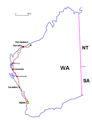
North West Coastal Highway in Western Australia is a generally north-south Western Australian highway which links the fishing town of Geraldton with the iron ore port of Port Hedland. It is 1,320 kilometres (820 mi) long, and constructed as a sealed 2-lane single carriageway with overtaking lanes in some parts. It was completely sealed by 1974 [1]. Together with Brand Highway it forms the coastal link between Perth and Port Hedland.
The highway is Western Australia's second longest, and is very remote in parts. Economically it is an important link to the Mid West, Gascoyne and Pilbara regions. The highway supports agriculture and fishing in the Mid West and Gascoyne, which transitions to mining, pastoral stations and offshore oil & gas production in the Pilbara.
Contents
Tourism
 North West Coastal Highway
Between Geraldton and Carnarvon, the highway passes through remote and dry semi-desert areas. There are no towns along the highway for about 400 km, with several roadhouses being the only settlements. Travellers are advised to bring adequate drinking water as the roadhouses do not provide it for free. On this stretch, a turnoff at the Overlander Roadhouse leads to Shark Bay with its world-famous Monkey Mia via a stretch of road known as World Heritage Drive.[2]
Carnarvon, the only town between Geraldton and Karratha, marks a change in climate. Bananas and other subtropical fruits are grown here. Unlike the subtropical areas on the east coast, the climate is much drier, but Carnarvon is also notorious as one of Western Australia's windiest locations[citation needed].
Further north, the highway passes through desert and becomes very flat. Bridges span many creeks and rivers, which from the distance can be spotted by stands of eucalyptus which grow along their courses towering above the surrounding spinifex[disambiguation needed
 ] and mulga[disambiguation needed ] plants. Most of the time these creeks and rivers are dry; however between November and April, the passage of cyclones and other rain bearing depressions can cause the rivers to rise from dry to over 10 metres deep in less than a day.
Near Minilya Roadhouse is the turnoff to the North West Cape area which is home to the tourist destinations of Cape Range National Park, Coral Bay and Exmouth. Exmouth is also home to the US Navy communications base.
 Maitland River bridge following Cyclone Monty, 2004
Further north the road goes inland and crosses the Ashburton River near Nanutarra Roadhouse. Nearby is the access road to the mining towns of Tom Price, Paraburdoo and the former asbestos ghost town, Wittenoom. After crossing the Robe River, Fortescue River and Maitland River, the highway reaches Karratha. Karratha, together with its nearby sister town Dampier, is home to the North West Shelf oil & gas project, and the Pilbara's number two iron ore exporting port. A little further east, Roebourne is the gateway to Wickham and Point Samson, the region's number three iron ore port. The highway finishes in Port Hedland/South Hedland, the region's number one iron ore port and one of the largest towns in WA's northwest, with 15,000 residents.
The remoteness of the northwest can be gauged by the number of roadhouses serving the highway which are the only settlements for some of the long stretches of the highway. Significant distances separate larger towns such as Geraldton, Carnarvon and Port Hedland with extensive rangeland expanses. The highway provides access to some of the better known tourist destinations in the North West of Western Australia.
Towns and settlements
Towns, settlements, junctions and significant roadhouses on and slightly off this highway include:
- Geraldton
- Northampton
- Binnu
- Kalbarri
- Billabong Roadhouse
- Overlander Roadhouse
- Wooramel Roadhouse
- Carnarvon
- Minilya Roadhouse
- Nanutarra Roadhouse
- Pannawonica
- Fortescue River Roadhouse (21°17′44.32″S 116°08′17.52″E / 21.2956444°S 116.1382°E)
- Karratha
- Dampier
- Roebourne
- Cossack
- Wickham
- Point Samson
- Whim Creek
- South Hedland
- Port Hedland
See also
References
- ^ Edmonds, Leigh (1997)The vital link : a history of Main Roads Western Australia 1926-1996 Nedlands, W.A. : University of Western Australia Press. ISBN 1876268069. page 450 opened 6th December 1974
- ^ [1]
 Road infrastructure in Western Australia
Freeways 
Metropolitan highways Highways and major roads Albany Highway • Brand Highway • Brockman Highway • Brookton Highway • Bussell Highway • Coalfields Road • Coolgardie-Esperance Highway • Dampier Highway • Derby Highway • Eyre Highway • Forrest Highway • Geraldton-Mount Magnet Road • Goldfields Highway • Great Eastern Highway • Great Northern Highway • Great Southern Highway • Indian Ocean Drive • Mandjoogoordap Drive • Muirs Highway • North West Coastal Highway • Old Coast Road • South Coast Highway • South Western Highway • Vasse Highway • Victoria HighwayOutback Tracks Anne Beadell Highway • Buntine Highway • Canning Stock Route • Cape Leveque Road • Connie Sue Highway • Duncan Road • Gary Highway • Gibb River Road • Great Central Road • Gunbarrel Highway • Kalumburu Road • Tanami RoadCategories:- Highways in rural Western Australia
- Pilbara


Wikimedia Foundation. 2010.