- New Albany, Indiana
-
City of New Albany, Indiana — City — Nickname(s): Sunny Side of Louisville, River City Location in the state of Indiana
Coordinates: 38°18′07″N 85°49′17″W / 38.30194°N 85.82139°WCoordinates: 38°18′07″N 85°49′17″W / 38.30194°N 85.82139°W Country United States State Indiana County Floyd Government – Mayor Jeff Gahan (D) Area – Total 14.8 sq mi (38.3 km2) – Land 14.6 sq mi (37.9 km2) – Water 0.2 sq mi (0.4 km2) Elevation 449 ft (137 m) Population (2010) – Total 36,372 – Density 2,570.3/sq mi (992.4/km2) Time zone EST (UTC-5) – Summer (DST) EDT (UTC-4) ZIP codes 47150-47151 Area code(s) 812 FIPS code 18-52326[1] GNIS feature ID 0440013[2] Website www.cityofnewalbany.com New Albany (
 /ˈɑːlbəni/) is a city in Floyd County, Indiana, United States, situated along the Ohio River opposite Louisville, Kentucky. In 1900, 20,628 people lived in New Albany; in 1910, 20,629; in 1920, 22,992; and in 1940, 25,414. The population was 36,372 at the 2010 census. The city is the county seat of Floyd County[3]. It is bounded by I-265 to the north and the Ohio River to the south, and is considered part of the Louisville, Kentucky Metropolitan Statistical Area. The mayor of New Albany is Jeff Gahan, a Democrat, he was recently elected in 2011.
Contents
Historical populations Census Pop. %± 1830 2,079 — 1840 4,226 103.3% 1850 8,181 93.6% 1860 12,647 54.6% 1870 15,396 21.7% 1880 16,423 6.7% 1890 21,059 28.2% 1900 20,628 −2.0% 1910 20,629 0% 1920 22,992 11.5% 1930 25,819 12.3% 1940 25,414 −1.6% 1950 29,346 15.5% 1960 37,812 28.8% 1970 38,402 1.6% 1980 37,103 −3.4% 1990 36,322 −2.1% 2000 37,603 3.5% 2010 36,372 −3.3% Source: US Census Bureau The land of New Albany was officially granted to the United States after the American Revolutionary War. The territory had been captured by George Rogers Clark in 1779. For his services Clark was awarded large tracts of land in Southern Indiana including most of Floyd County. After the war Clark sold and distributed some of his land to his fellow soldiers. The area of New Albany ended up in the possession of Col. John Paul.
Early history
New Albany was founded in July 1813 when three brothers from Albany, New York—Joel, Abner, and Nathaniel Scribner—arrived at the Falls of the Ohio and named the site after their home. They purchased the land from Col. John Paul. New Albany was platted by John Graham on the land owned by the Scribner brothers. In 1814 Joel and Mary Scribner built their home in New Albany, the Scribner House[4] still stands today.
New Albany was incorporated as a town in 1817 as part of Clark County. In 1819, three years after Indiana was admitted as a state, New Albany became the seat of government for newly established Floyd County.[5] A courthouse was finally built in 1824. New Albany was incorporated as a city in 1839. It would remain one of the largest cities in the mid-west for the next 50 years.
Boom town
 A Carnegie library in New Albany
The steamboat industry was the engine of the city's economy during the mid-19th century. At least a half-dozen shipbuilders were in operation and turned out a multitude of steamboats and packet boats including the Robert E. Lee, Eliza Battle, the Eclipse, and the A.A. Shotwell. Shipbuilding was accompanied by a wide range of ancillary business including machine shops, foundries, cabinet and furniture factories, and silversmith shops. Its second largest business was the American Plate Glass Works. By 1850, New Albany was the largest city in Indiana due to its river contacts with the South. New Albany's size and economic influence overshadowed all of its neighboring cities, including Louisville.
In 1853 the New Albany High School opened, the first public high school in the state. The original school was built at the corner of West First Street and Spring Street. New Albany would also be the first in the state to create a consolidated school district several years later.
Before the Civil War. Over half of Hoosiers with over $100,000 lived in New Albany[6] making it by far the wealthiest part of the state.
Ashbel P. Willard, Governor of the State of Indiana and a native of New Albany, dedicated the Floyd County Fairgrounds in 1859. That year the Indiana State Fair was held in New Albany. During the Civil War the fairgrounds were converted to become Camp Noble and used as a muster point for the area's regiments.
In 1862 Abraham Lincoln established one of the first seven National Cemeteries in New Albany for burying the many war dead.
A new larger courthouse was built in 1865 which was used until the 1960s when the current City-County courthouse was constructed, also the first in Indiana.
 Town Clock Church
The Town Clock Church, now the Second Baptist Church, was used as the New Albany stop in the Underground Railroad.[7]
During the American Civil War the trade with the South dwindled, and after the War much of Indiana saw New Albany as too friendly to the South. The city never regained its stature, remaining a city of 40,000 with only its antebellum/early-Victorian “Mansion-Row” buildings to remind itself of its boom period. New Albany’s robust steamboat industry ended by 1870, with the last steamboat built in New Albany named, appropriately, the Robert E. Lee.
During the second half of the 19th century New Albany experienced an industrial boom despite the collapse of the steamboat industry. The advent of the railroad created economic opportunity for the city as a pork packing and locomotive repair center. A bridge was built across the River in 1886 providing a rail and road connection with Kentucky. American Plate Glass Works opened in 1865 which employed as many as 2,000 workers. When the factory relocated in 1893 New Albany lost a large part of its population and went into economic decline.
20th century
In the early 20th century, New Albany became a center of plywood and veneer, and its largest employer was the New Albany Veneering Company. By 1920, New Albany was the largest producer of plywood and veneer in the world with other producers including Indiana Veneer Panel Company and Hoosier Panel Company.
Interstate 64 came through New Albany in 1961 and led to the construction of the Sherman Minton Bridge. The project cost 14.8 million dollars. The bridge was named for US Senator and later Supreme Court Justice Sherman Minton who was a native of nearby Georgetown and practiced law in New Albany. The bridge was named the "most beautiful long-span bridge of 1961" by the American Institute of Steel Construction.
Charles Allen Prosser lived in New Albany for much of his life. Charles Allen Prosser School of Technology was named in honor of his accomplishments as the "Father of Vocational Education." In the mid and late 20th century, New Albany became an innovator in using electronic media in education. New Albany High School, a public school, started WNAS-FM in 1949, which is the nation's oldest continuously operating high school radio station. In the late 1960s, Slate Run Elementary School started WSRS, a non-licensed student-produced closed circuit television service for its classrooms, one of the nation's first in an elementary school.
Ohio River flood
Main article: Ohio River flood of 1937In January 1937 a terrible flood affected New Albany and the region. New Albany, like the other river towns, had no flood walls and no methods of regulating the river. The Ohio River rose to 60.8 feet at New Albany leaving most of the town under 10 or more feet of water for nearly three weeks. The flood would be the worst disaster to ever befall the city.
After the flood New Albany was the first city in the region to begin construction on massive flood walls around the city. New Albany's flood walls would serve as examples for those that would later be constructed around Louisville and Clark County.
Notable people
- Charles M. La Follette - member of Congress, was born in New Albany.
- George W. Maher - early 20th century Prairie School style architect
- Sherman Minton - United States Supreme Court Justice who practiced law in New Albany. He is buried in the city's Holy Trinity Catholic Cemetery. The I-64 double-decker bridge that crosses the Ohio River between New Albany and Louisville, Kentucky is named for him.
- Shanda Sharer - girl who was tortured and burned to death by four teenage girls.
- Fuzzy Zoeller - PGA golfer - 1979 Masters Champion and 1984 U.S. Open Champion
- Camille Wright Thompson (born March 5, 1955 New Albany, Indiana) is a former American swimmer. Wright won a silver medal at the 1976 Summer Olympics in Montreal.Beat by the East German swimmers.Graduate of New Albany High School 1973,University of Hawaii1979. .http://www.nytimes.com/1998/10/25/sports/olympics-us-seeks-redress-for-1976-doping-in-olympics.html
- Mike Wolfe - Pro Bowler on the PBA Tour, winner of the Earl Anthony Classic
- Robert C. Harding - Academic, author, and noted expert on Latin American, international security, and space policy issues. Graduate of Our Lady of Providence High School.
- Rob Conway - Former WWE Wrestler
- Joseph Ritter - Cardinal
- Four Reno Gang members were lynched in the New Albany Jail by masked vigilantes from Jackson County in 1868
- Charles Allen Prosser - the Father of Vocational Education - C. A. Prosser School of Technology in New Albany is named in his honor.
- Mike Sodrel- Former congressman of Indiana's 9th district.
- Ashbel P. Willard- 11th Governor of Indiana
- Edwin Hubble - Astronomer and namesake of the Hubble Space Telescope was a physics and Spanish teacher and basketball coach at New Albany High School during the 1913-1914 academic year.[8]
- John M. Stotsenburg - United States Army colonel killed in the Philippine-American War.
- John MacLeod - college basketball and NBA coach.
- Craig Pumphrey - Current Police Officer for the city. Know well as a Television presenter and martial artist.
- Gregg Seidl-Author of "Images of America: New Albany," "Wicked New Albany,"and local historian and tour guide.
- Jouett Meekin - pitcher who won 153 games in Major League Baseball
Attractions
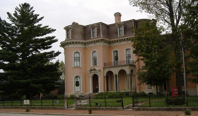
 The Culbertson Mansion in New Albany
New Albany's Main Street features a large collection of late 19th century mansions from the city's heyday as a shipbuilding center. The centerpiece is the Culbertson Mansion, a three-story French Second Empire Style structure, which is today an Indiana state memorial.
Every October, the downtown area of New Albany is host to the Harvest Homecoming festival, one of the largest annual events in the state. Festivities begin on the first weekend of October, but the main part, consisting of midway rides, shows, and booths lining the downtown streets, lasts from Thursday-Sunday of the second weekend in October.
Geography
New Albany is located at 38°18′07″N 85°49′17″W / 38.301935°N 85.821442°W (38.301935, -85.821442).[9]
According to the United States Census Bureau, the city has a total area of 14.8 square miles (38 km2), of which, 14.6 square miles (38 km2) of it is land and 0.2 square miles (0.52 km2) of it (1.15%) is water.
Demographics
As of the census[1] of 2000, there were 37,603 people, 15,959 households, and 10,054 families residing in the city. The population density was 2,571.1 people per square mile (992.4/km2). There were 17,098 housing units at an average density of 1,169.1 per square mile (451.2/km2). The racial makeup of the city was 84.00% White, 12.93% African American, 0.31% Native American, 0.42% Asian, 0.04% Pacific Islander, 0.67% from other races, and 1.62% from two or more races. 1.36% of the population is Hispanic (Hispanics can be of any race).
There were 15,959 households out of which 29.6% had children under the age of 18 living with them, 42.5% were married couples living together, 16.1% had a female householder with no husband present, and 37.0% were non-families. 30.8% of all households were made up of individuals and 11.7% had someone living alone who was 65 years of age or older. The average household size was 2.31 and the average family size was 2.88.
In the city the population was spread out with 24.0% under the age of 18, 9.6% from 18 to 24, 29.2% from 25 to 44, 21.8% from 45 to 64, and 15.4% who were 65 years of age or older. The median age was 37 years. For every 100 females there were 88.5 males. For every 100 females age 18 and over, there were 84.6 males.
The median income for a household in the city was $34,923, and the median income for a family was $41,993. Males had a median income of $31,778 versus $24,002 for females. The per capita income for the city was $18,365. About 11.4% of families and 13.7% of the population were below the poverty line, including 21.6% of those under age 18 and 9.1% of those age 65 or over.
See also
- List of mayors of New Albany, Indiana
- List of cities and towns along the Ohio River
- New Albany High School
- Indiana University Southeast
References
- ^ a b "American FactFinder". United States Census Bureau. http://factfinder.census.gov. Retrieved 2008-01-31.
- ^ "US Board on Geographic Names". United States Geological Survey. 2007-10-25. http://geonames.usgs.gov. Retrieved 2008-01-31.
- ^ "Find a County". National Association of Counties. http://www.naco.org/Counties/Pages/FindACounty.aspx. Retrieved 2011-06-07.
- ^ Today the house is owned by the local chapter of the Daughters of the American Revolution
- ^ The History of New Albany
- ^ Miller, Harold. Industrial Development of New Albany, Indiana. Economic Geography (Jan., 1938). 48.
- ^ Historic New Albany
- ^ The European Homepage For The NASA/ESA Hubble Space Telescope - The man behind the name
- ^ "US Gazetteer files: 2010, 2000, and 1990". United States Census Bureau. 2011-02-12. http://www.census.gov/geo/www/gazetteer/gazette.html. Retrieved 2011-04-23.
External links
Louisville, Kentucky • Portal Subject areas Attractions/Events • Cityscape • Economy • Education • Geography • Government • History • Media • Neighborhoods • Parks • People • Performing arts • Sports • Transportation
Top subjects National
Historic
LandmarksProminent suburbs
(over 10K pop.)Bardstown • Clarksville • Jeffersontown • Jeffersonville • Mount Washington • New Albany • St. Matthews • Shelbyville • Shepherdsville • ShivelyMunicipalities and communities of Floyd County, Indiana County seat: New AlbanyCity New Albany

Towns Townships Franklin | Georgetown | Greenville | Lafayette | New Albany
Unincorporated
communitiesBlackiston Mill | Duncan | Edwardsville | Floyds Knobs | Galena | Mount St. Francis | Navilleton | Saint Joseph | Saint Marys | Scottsville
 State of Indiana
Topics - Index
- Demographics
- Economy
- Geography
- Government
- Governor (List)
- Congressional districts (Delegations)
- History
- Hoosiers
- City Nicknames
- National Historic Landmarks
- Sports
- State parks
- Symbols
- Transportation
- Visitor Attractions
- Index of Indiana-related articles
- Outline
Regions - Central Indiana
- East Central Indiana
- Illinois-Indiana-Kentucky Tri-State Area
- Indiana-Kentucky-Ohio Tri-State Area
- Michiana
- Northern Indiana
- Northwest Indiana
- Southern Indiana
- Southwestern Indiana
- Wabash Valley
Largest cities - Indianapolis
- Fort Wayne
- Evansville
- South Bend
- Hammond
- Bloomington
- Gary
- Carmel
- Lafayette
- Muncie
- Anderson
- Terre Haute
- Elkhart
- Kokomo
- Mishawaka
- Richmond
- Columbus
- Lawrence
- Jeffersonville
- Greenwood
- New Albany
- Portage
- Michigan City
- East Chicago
- Goshen
- Marion
- Valparaiso
- Noblesville
- West Lafayette
- Hobart
- Crown Point
- Franklin
- La Porte
- Seymour
- Logansport
- New Castle
- Connersville
- Vincennes
- Bedford
- Jasper
- Washington
- Princeton
- Westfield
Largest towns Counties - Adams
- Allen
- Bartholomew
- Benton
- Blackford
- Boone
- Brown
- Carroll
- Cass
- Clark
- Clay
- Clinton
- Crawford
- Daviess
- Dearborn
- Decatur
- DeKalb
- Delaware
- Dubois
- Elkhart
- Fayette
- Floyd
- Fountain
- Franklin
- Fulton
- Gibson
- Grant
- Greene
- Hamilton
- Hancock
- Harrison
- Hendricks
- Henry
- Howard
- Huntington
- Jackson
- Jasper
- Jay
- Jefferson
- Jennings
- Johnson
- Knox
- Kosciusko
- LaGrange
- Lake
- LaPorte
- Lawrence
- Madison
- Marion
- Marshall
- Martin
- Miami
- Monroe
- Montgomery
- Morgan
- Newton
- Noble
- Ohio
- Orange
- Owen
- Parke
- Perry
- Pike
- Porter
- Posey
- Pulaski
- Putnam
- Randolph
- Ripley
- Rush
- Saint Joseph
- Scott
- Shelby
- Spencer
- Starke
- Steuben
- Sullivan
- Switzerland
- Tippecanoe
- Tipton
- Union
- Vanderburgh
- Vermillion
- Vigo
- Wabash
- Warren
- Warrick
- Washington
- Wayne
- Wells
- White
- Whitley
Categories:- Cities in Indiana
- New Albany, Indiana
- Underground Railroad locations
- County seats in Indiana
- Louisville metropolitan area
- Populated places in Floyd County, Indiana


Wikimedia Foundation. 2010.