- Dana, Indiana
-
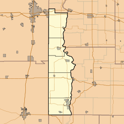
Dana — Town — Vermillion County's location in Indiana Map of Dana Dana's location in Vermillion County Coordinates: 39°48′24″N 87°29′39″W / 39.80667°N 87.49417°WCoordinates: 39°48′24″N 87°29′39″W / 39.80667°N 87.49417°W Country United States State Indiana County Vermillion Township Helt Established 1874 Area – Total 0.3 sq mi (0.8 km2) – Land 0.3 sq mi (0.8 km2) – Water 0.0 sq mi (0.0 km2) Elevation 640 ft (195 m) Population (2010) – Total 608 – Density 2,282.8/sq mi (881.4/km2) Time zone EST (UTC-5) – Summer (DST) EST (UTC-5) ZIP code 47847 Area code(s) 765 FIPS code 18-16732[1] GNIS feature ID 0433305[2] Dana is a town in Helt Township, Vermillion County, Indiana, United States. The population was 608 at the 2010 census. It is primarily a farming community.
Famed World War II war correspondent Ernie Pyle was born on a tenant farm near Dana. Bert Shepard, a Major League Baseball pitcher for the Washington Senators who had lost his leg in WWII, was also born in Dana.
Contents
History
The town was laid out in 1874 and was named for Charles Dana who was a local railroad stockholder and famous newspaper editor.[3]
Geography
Dana is located at 39°48′24″N 87°29′39″W / 39.80667°N 87.49417°W (39.806714, -87.494256)[4].
According to the United States Census Bureau, the town has a total area of 0.3 square miles (0.78 km2), all of it land.
Demographics
As of the census[1] of 2000, there were 662 people, 252 households, and 187 families residing in the town. The population density was 2,255.4 people per square mile (881.4/km²). There were 288 housing units at an average density of 981.2 per square mile (383.4/km²). The racial makeup of the town was 97.58% White, 0.60% African American, 0.30% Asian, 0.76% from other races, and 0.76% from two or more races. Hispanic or Latino of any race were 1.66% of the population.
There were 252 households out of which 33.7% had children under the age of 18 living with them, 62.7% were married couples living together, 8.7% had a female householder with no husband present, and 25.4% were non-families. 23.0% of all households were made up of individuals and 9.9% had someone living alone who was 65 years of age or older. The average household size was 2.63 and the average family size was 3.05.
In the town the population was spread out with 28.4% under the age of 18, 6.8% from 18 to 24, 28.7% from 25 to 44, 23.9% from 45 to 64, and 12.2% who were 65 years of age or older. The median age was 36 years. For every 100 females there were 95.9 males. For every 100 females age 18 and over, there were 94.3 males.
The median income for a household in the town was $34,750, and the median income for a family was $38,182. Males had a median income of $30,313 versus $21,875 for females. The per capita income for the town was $15,603. About 6.6% of families and 9.9% of the population were below the poverty line, including 14.4% of those under age 18 and 9.5% of those age 65 or over.
Facts
The famous war correspondent Ernie Pyle grew up just outside Dana. Today the town boasts a museum that celebrates Pyle's life and career.
The US developed the Girdler Sulfide chemical exchange production process which was first demonstrated on a large scale at the Dana, Indiana plant in 1945.
Even though miles from any major body of water, Dana is home to a United States Coast Guard LORAN navigation transmitter station.
The last locomotive built by the American Locomotive Company (ALCO) currently is in use in Dana at the Cargill Ag Horizons elevator. The locomotive, a model T-6 switcher originally built for the Newburgh & South Shore in 1969, still retains it's original road number of 1017.
References
- ^ a b "American FactFinder". United States Census Bureau. http://factfinder.census.gov. Retrieved 2008-01-31.
- ^ "US Board on Geographic Names". United States Geological Survey. 2007-10-25. http://geonames.usgs.gov. Retrieved 2008-01-31.
- ^ Baker, Ronald L.; Marvin Carmony (1975). Indiana Place Names. Indiana University Press. p. 38. ISBN 0253141672.
- ^ "US Gazetteer files: 2010, 2000, and 1990". United States Census Bureau. 2011-02-12. http://www.census.gov/geo/www/gazetteer/gazette.html. Retrieved 2011-04-23.
Municipalities and communities of Vermillion County, Indiana City Towns Cayuga | Dana | Fairview Park | Newport | Perrysville | Universal
Townships Clinton | Eugene | Helt | Highland | Vermillion
Unincorporated
communitiesAlta | Blanford | Bono | Centenary | Crompton Hill | Easytown | Eugene | Flat Iron | Gessie | Highland | Hillsdale | Jonestown | Klondyke | Needmore | Rhodes | Rileysburg | Saint Bernice | Sandytown | Summit Grove | Syndicate | Tree Spring | West Clinton | West Dana
Ghost towns Categories:- Populated places in Vermillion County, Indiana
- Towns in Indiana
- Populated places established in 1874
- Terre Haute metropolitan area
Wikimedia Foundation. 2010.


