- Chanakyapuri
-
Chanakyapuri — neighbourhood — Coordinates Country India Territory Delhi District(s) New Delhi Parliamentary constituency New Delhi Civic agency New Delhi Municipal Corporation Time zone IST (UTC+05:30) Chanakyapuri (Hindi: चाणक्यपुरी, Urdu: چانکیہپوری) is an affluent neighborhood and Diplomatic Enclave in New Delhi, established in 1950s, and located about 14 km. from Delhi Airport. Chanakyapuri, literally meaning "City of Chanakya", is named for Chanakya, a third century BC Maurya advisor and prime minister.[1]
Chanakyapuri plays host to a majority of foreign embassies in India, and is home to a number of their staffs. Chanakyapuri was also developed as official residences for both politicians and civil servants to the Union Government. As such, it has numerous parks and open spaces, and suffers few utility disruptions.It is also located near to the Prime Minister's Residence.
Contents
History
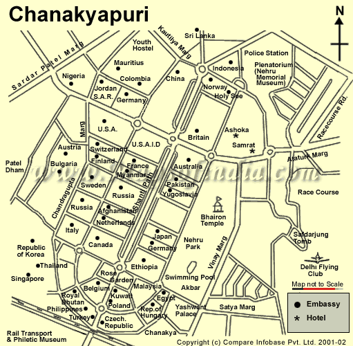
It was first major extension of New Delhi, outside the Lutyens' Delhi, when the Central Public Works Department (CPWD) developed a large area of land close to Lutyens Delhi to create a diplomatic enclave in 1950s. Subsequently land was allotted for embassies, chanceries, high commissions and residences of ambassadors. The enclave was set up around a wide central vista, known as Shanti Path (Peace Road), with wide green areas, and a large landscaped park spread over an area of 80 acres, known as Nehru Park was developed in 1969, for the families of diplomatic staff. With the park stand the ancient Bhairon Temple. Gradually, two markets, two colleges and schools run by diplomatic mission including, ‘The British School’ and the ‘American School’ were opened.[2][1]
Transportation
Major roads in Chanakyapuri include Shanti Path, as well as Nyaya Marg, Niti Marg, Chandragupta Marg and Panscheel Marg. In addition, the Ring Road traverses immediately south of the neighborhood and intersects with National Highway 8 on the border of Chanakyapuri and neighboring Dhaula Kuan. Sardar Patel Marg marks the Western periphery, while ‘Chanakya cinema’ complex, which lies beyond Nehru Park, marks south-west periphery.
The 'Delhi Ring Railway' has a stop at Chanakyapuri. Race Course and Jor Bagh are the nearest underground stations of Delhi Metro.
Points of interest
Amongst the embassies, there are considerable architectural delights:
- The Ashok Hotel, which hosts a yearly one-day Bazaar where many embassies present items from their countries for sale
- The United States Embassy and Chancery were designed by Edward Durrell Stone, in 1959.
- The Russian Embassy embodies Stalinist architectural principles.
- The British High Commission and German Embassy were constructed in similar styles during the 1950s.
- The Thai Embassy and the Pakistani High Commission are visually striking; the latter is built in classical Islamic style, with minarets and blue-tiled onion domes.
- The Polish Embassy is an unusually large and expensive product of 1970's overoptimistic "Gierek era".
Chanakyapuri is also home to:
- The American Embassy School, primarily serving American and other expatriates located in Delhi.
- The British School that offers the British National Curriculum, IGCSE and IB. Primarily serving the international community.
- The Jesus and Mary College, part of the University of Delhi.
- Maitreyi College, part of the University of Delhi.
- The National Rose Garden, open in December and January each year.
- The National Rail Museum, focusing on the rail heritage of India.
- Nehru Park, established in 1969.
- Bhairon Temple.
- Navy Children School, Delhi, estb. 1965
- Sanskriti School a renowned school which mainly serves kids of civil servants.
- Carmel Convent.
Chanakyapuri also has a number of hotels and services catering to both foreign and affluent domestic visitors to Delhi. Some of these include the Hotel Ashok, Hotel Samrat, Maurya Sheraton, Taj Palace, Claridges and Diplomat, apart from the Youth Hostels Association of India. Apollo Hospitals also operates the International Hospital, located on the western side of Chanakyapuri.
See also
- Areas And Zones of New Delhi
- Sarojini Nagar Market
References
- ^ a b Travel Delhi, India. MobileReference. 2007. ISBN 1605010510. http://books.google.co.in/books?id=MsYj4ysWQ6sC&pg=PT434&dq=Chanakyapuri&hl=en&ei=RTd2Tqr2IcnqrAfV3fy_Aw&sa=X&oi=book_result&ct=result&resnum=1&ved=0CC0Q6AEwAA#v=onepage&q=Chanakyapuri&f=false.
- ^ Viswambhar Nath (2007). "Delhi Before 1947". Urbanization, urban development, and metropolitan cities in India. Concept Publishing Company. p. 248. ISBN 8180694127. http://books.google.co.in/books?id=Obd1vEVEPdgC&pg=PA244&dq=Paharganj&hl=en&ei=QJl1Ttz3HM7KrAe3krXAAw&sa=X&oi=book_result&ct=result&resnum=2&ved=0CDUQ6AEwAThG#v=onepage&q=Paharganj&f=false.
External links
Neighborhoods of Delhi Ashok Nagar · Ashok Vihar · Ashram Chowk · Ber Sarai · Bank Enclave · Chanakyapuri · Chandni Chowk · Chawri Bazaar · Chittaranjan Park · Civil Lines · Connaught Place · Daryaganj · Dayanand Colony · Defence Colony · Delhi Cantonment · Derawal Nagar · Dhaula Kuan · Dwarka Sub City · Faridabad · Gandhi Nagar · Geetanjali Enclave · Ghaziabad · Gole Market · Govindpuri · Greater Kailash · Green Park · Gulmohar Park · Gurgaon · Hauz Khas · Inder puri · Indirapuram · Kalkaji · Kamla Nagar · Kapasheda · Kashmere Gate · Kirti Nagar · Kotla Mubarakpur · Lajpat Nagar · Lutyens' Delhi · Malviya Nagar · Mayur Vihar · Mehrauli · Model Town, Delhi · Munirka · Najafgarh · Nehru Place · New Friends Colony · Netaji Nagar · New Delhi · Nizamuddin East · Nizamuddin West · Noida · Okhla · Paharganj · Palika Bazaar · Pandav Nagar · Paschim Vihar · Patel Nagar · Pitam Pura · Prakash Vir Shastri Avenue · Preet Vihar · Punjabi Bagh · Karol Bagh · Raisina Hill · Rajouri Garden · Rajender Nagar · Ramakrishna Puram · Rohini Township · Sadar Bazaar · Saket · Sarita Vihar · Sarojini Nagar · Shahdara · Shahdara Maujpur Yamuna Vihar · Shahdara, Delhi · Shahpur Jat · Shalimar Bagh · Shastri park · Shivaji Place · South Extension · Tilak Nagar · Urdu Bazar · Vasant Kunj · Vasant Vihar · Vasundhara Enclave · Vikaspuri · Yamuna Vihar ·
Categories:- Neighbourhoods of Delhi
- District subdivisions of Delhi
- Diplomatic districts
- New Delhi district
- Cities and towns in New Delhi district
- 1950s establishments in India
Wikimedia Foundation. 2010.