- Mount Batten
-
Not to be confused with Mountbatten or Earl Mountbatten of Burma.For the RAF seaplane station and flying boat base, see RAF Mount Batten.
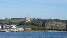 Mount Batten from Plymouth Hoe
Mount Batten is a 24-metre-tall outcrop of rock on a 600-metre peninsula in Plymouth Sound, Devon, England.
After some redevelopment which started with the area coming under the control of the Plymouth Development Corporation for five years from 1993, the peninsula now has a marina and centre for sea sport.
The Mount Batten Breakwater (also referred to as Cattewater Breakwater and Mount Batten Pier) to the west doubles as a breakwater for the Cattewater and Sutton Harbour. It was built in 1881 by the Cattewater Commissioners and subsequently refurbished by the Plymouth Development Corporation opening formally in 1995.
Contents
History
Early History
According to excavations reported by Barry Cunliffe in 1988, Mount Batten was the site of the earliest trade with Europe yet discovered in Britain, operating from the late Bronze Age, peaking in the late Iron Age and continuing in operation throughout the Roman period.[1] It appears to have been the primary route of entry to Britain for large quantities of continental commodities such as wine, and is therefore a speculative candidate for the 'TAMARIS' of Ptolemy's Geographia.[2] A fine British-made bronze mirror was also found on the peninsula.[citation needed]
Coastal erosion
Before the Plymouth Breakwater was completed in 1841 and the Mount Batten Breakwater in1881, the Mount Batten peninsula was subject to significant coastal erosion. In the 17th century, maintenance of the Cattewater required annual removal of silt and rubble which was dumped on the south side of Mount Batten. However, in 1633 and 1634 the Mount Batten isthmus was breached. A sea wall was built to resolve the problem but it wasn’t until the breakwaters were built that the problem was finally solved.
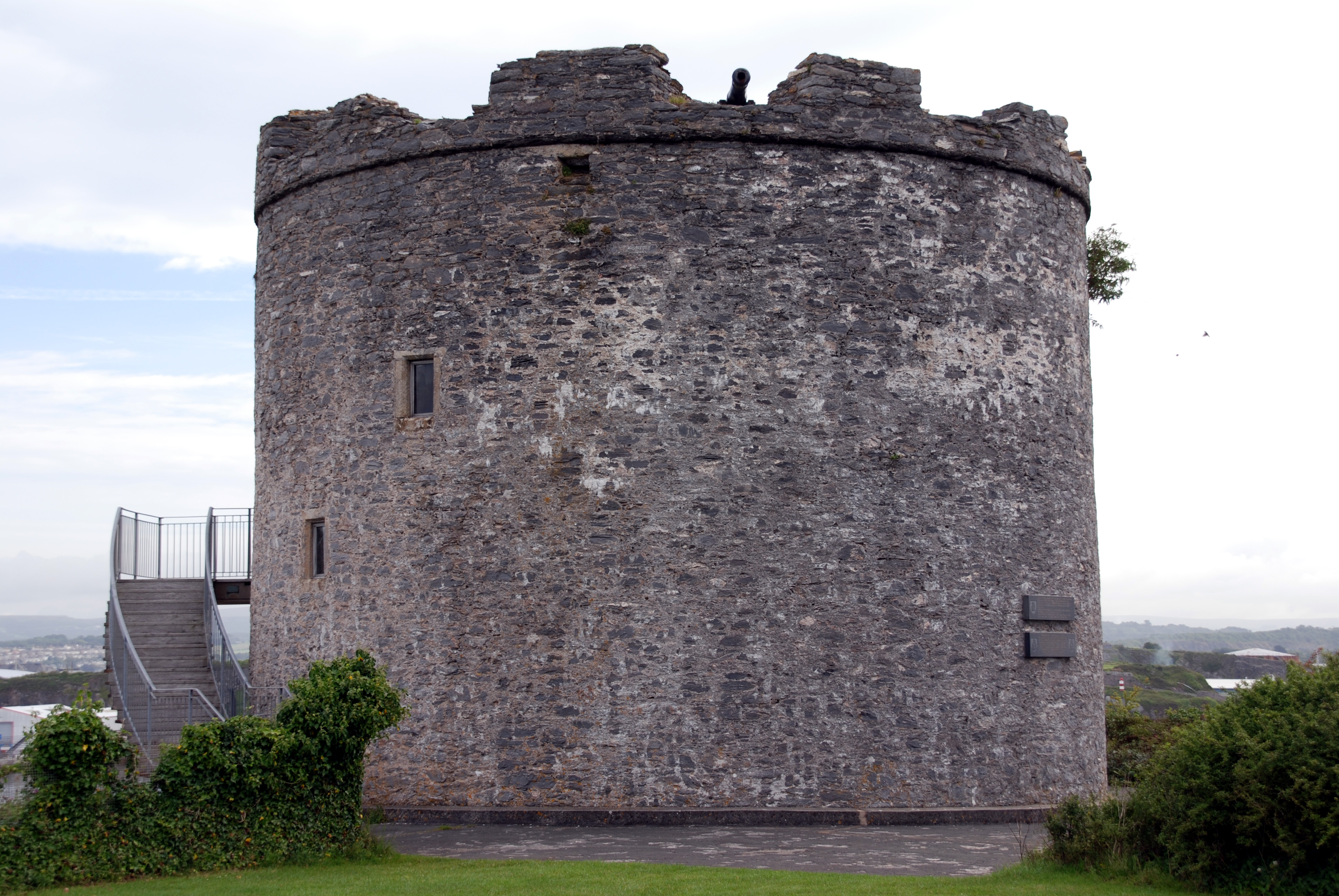
Mount Batten Tower
 Mount Batten Tower
In the later Medieval period it became an important defensive point for the developing settlement at Plymouth Harbour, providing a field of fire from across the other side of the Cattewater, the channel connecting the old town to the sea. In 1652, Mount Batten Tower, a 30 foot high circular artillery fort was built here; it is a Scheduled Ancient Monument.[3]
Maritime incidents
In 1973, a short distance from Mount Batten, the Cattewater Wreck’ was discovered during dredging. Subsequent survey and excavation work indicated that the wreck was of a 200-300 ton merchantmen believed to have been lost in the early 16th Century. It has the distinction of being the first wreck to be protected under the Protection of Wrecks Act 1973. On 16 February 1811, the frigate HMS Amethyst wrecked on the ground near Cony Cliff Rocks, Mount Batten. Eight seamen lost their lives.
Quarrying at Mount Batten
Extensive quarrying took place at Mount Batten between 1839 and the mid 1860s. .[4] Stones from the quarry were used for building steam yards at HMNB Devonport. The quarrying substantially changed the local landscape and threatened the Mount Batten Tower. Following a petition from 53 leading citizens to the Admiralty, Lord Morley, the landowner, imposed restrictions on quarrying thereby saving the tower.
Mount Batten Breakwater
Work on the Mount Batten Breakwater]].[5] (also referred to as Mount Batten Pier and Cattewater Breakwater) started in 1878 and was completed in 1881 at a total cost of £20,000. It is 915 feet (279 metres)in length and the foundations are 20 feet (6 metres) below the low tide mark. The breakwater was promoted by the Cattewater Commissioners who were responsible for shipping in the area. During the air-station years the breakwater was closed to the public and used, for a period, to store flying boats. In 1995 the breakwater was refurbished and re-opened to the public.
Early tourism
The coastal walk to Jennycliff and local inns, originally built to service those working on the quarries, helped make Mount Batten an increasingly popular destination for Plymouthians. During one bank holiday in 1906, some 10,000 visitors took the ferry to the area. This fledgling tourist industry came to an abrupt end when the area was closed to the public.
The air-station years (1913-1986)
Sea plane trials first took place around Mount Batten as early as 1913 and an air-station was subsequently developed. A local commemorative display poster cites the following names and years for the air station
- 1913-1918 as RNAS Cattewater
- 1918-1928 as RAF Cattewater
- 1928-1986 as RAF Mount Batten
Between 1917 and 1945, with some gaps, it was a flying boat base for both the Royal Air Force and the Royal Navy. The RAF operated search and rescue launches from the base. T. E. Lawrence was stationed there under the moniker Aircraftsman Shaw.[6]
Shorts Sunderland flying boats of the Royal Australian Air Force operated from RAF Mount Batten during World War II, taking part in the Battle of the Atlantic. The RAF finally left in 1986.
Recent History
The former RAF Mount Batten site was transferred to the Plymouth Development Corporation in 1992 In 1999 the Mount Batten Sailing and Watersports Centre opened on the site of the former sergeants' mess. The peninsula is also home to a small residential community with 22 houses, Spinnaker Quay, dating from 2001.
References
- ^ Barry Cunliffe : Mount Batten Plymouth: A Prehistoric and Roman Port. Oxford University Press 1988
- ^ "Tamaris - Probable Settlement and Port". www.Roman-Britain.org. July 2004. http://www.roman-britain.org/places/tamaris.htm. Retrieved 2008-08-22.
- ^ http://www.ecastles.co.uk/mountbatten.html
- ^ Gerald Wasley: Mount Batten- The Flying Boats of Plymouth, Halsgrove, 2006
- ^ "Encyclopaedia of Plymouth History: Mount Batten Breakwater". www.plymouthdata.info. 19 January 2011. http://www.plymouthdata.info/Mount%20Batten%20Breakwater.htm. Retrieved 2011-08-15.
- ^ Beauforte-Greenwood, W. E. G. "Notes on the introduction to the RAF of high-speed craft". T. E. Lawrence Studies. http://www.telawrencestudies.org/telawrencestudies/service_years/high-speed_craft.htm. Retrieved 2011-04-11.
Categories:- Geography of Devon
- Plymouth, Devon
- Former populated places in England

Wikimedia Foundation. 2010.