- Racetrack Playa
-
Racetrack Playa 
Location Death Valley National Park
Inyo County, CaliforniaCoordinates 36°40′53″N 117°33′46″W / 36.6813°N 117.5627°WCoordinates: 36°40′53″N 117°33′46″W / 36.6813°N 117.5627°W Lake type Endorheic basin Primary outflows Terminal (evaporation) Basin countries United States Max. length 4.5 km (2.8 mi) Max. width 2 km (1.2 mi) Surface area 7 km2 (2.7 sq mi) Shore length1 12 km (7.5 mi) Surface elevation 1,132 m (3,714 ft) References U.S. Geological Survey Geographic Names Information System: The Racetrack 1 Shore length is not a well-defined measure. The Racetrack Playa, or The Racetrack, is a scenic dry lake feature with "sailing stones" that leave linear "racetrack" imprints. It is located above the northwestern side of Death Valley, in Death Valley National Park, Inyo County, California, U.S..
Contents
Geography
The Racetrack playa is 3608 feet (1130 m) above sea level, and 2.8 miles (4.5 km) long (north-south) by 1.3 miles (2 km) wide (east-west). It is also exceptionally flat and level with the northern end being only 1.5 inches (4 cm) higher than the southern. The highest point surrounding it is 5,678 feet (1731 m) high Ubehebe Peak, rising 1970 feet (571 m) above the lakebed 0.85 mile (1.37 km) to the west.
The playa is in the small Racetrack Valley endorheic basin between the Cottonwood Mountains on the east and Nelson Range to the west. During periods of heavy rain, water washes down from the mountains onto the playa, forming a shallow, short-lived endorheic lake. Under the hot desert sun the thin veneer of water quickly evaporates leaving behind a surface layer of soft slick mud. As the mud dries it shrinks and cracks into a mosaic pattern of interlocking polygons.
The shape of the shallow hydrocarbon lake Ontario Lacus on Saturn's moon Titan has been compared to that of Racetrack Playa. [1]
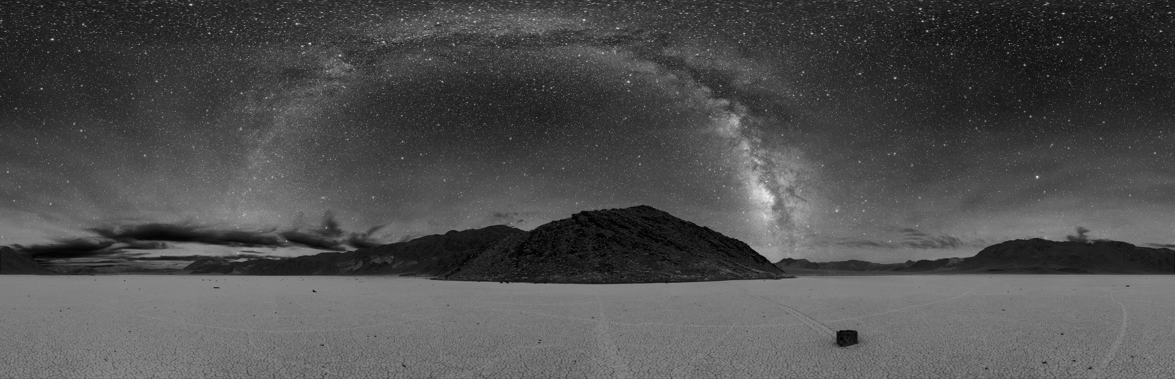
 360° night-time panorama of the Racetrack Playa. The Milky Way is the visible arc in the center above a sailing stone and tracks from others.
Features
The Racetrack
Racetrack is dry for almost the entire year and has no vegetation. When dry, its surface is covered with small but firm hexagonal mud crack saucers that are typically 3 to 4 inches (7.5 to 10 cm) in diameter and about an inch (2.5 cm) thick. During the bimodal rainy season (summer and especially winter) a shallow cover of water deposits a thin layer of fine mud on and between the saucers of Racetrack. Heavier winter precipitation temporarily erases them until spring when the dry conditions cause new mud cracks to form where the old ones had been. Sandblasting wind continually helps to round the edges of exposed saucers. Annual precipitation is 3 to 4 inches (75 to 100 mm) and ice cover can be 1 to 2.5 inches (2.5 to 6.5 cm) thick. Typically only part of the playa will flood in any given year.
Sailing stones
Main article: Sailing stones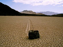
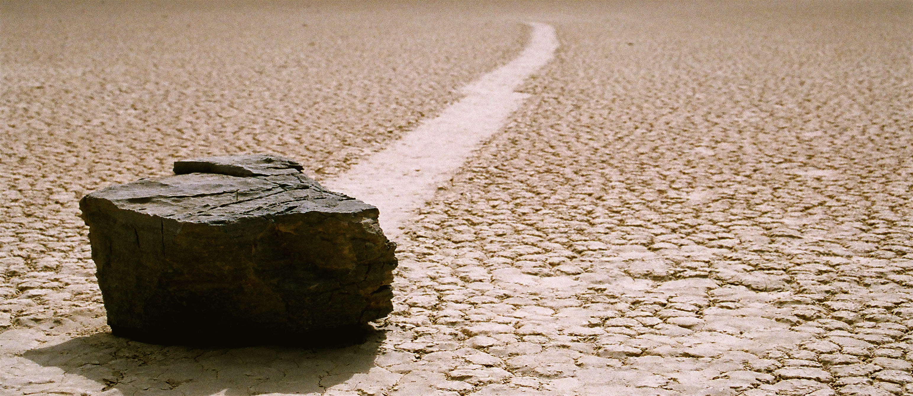
 Sailing stone in Racetrack Playa
The sailing stones are a geological phenomenon found in the Racetrack. The stones slowly move across the surface of the playa, leaving a track as they go, without human or animal intervention. They have never been seen or filmed in motion. Racetrack stones only move once every two or three years and most tracks last for three or four years. Stones with rough bottoms leave straight striated tracks while those with smooth bottoms wander. Stones sometimes turn over, exposing another edge to the ground and leaving a different-sized track in the stone's wake.[citation needed]
The sailing stones are most likely moved by strong winter winds, reaching 90 mph, once it has rained enough to fill the playa with just enough water to make the clay slippery. The prevailing southwest winds across Racetrack playa blow to northeast. Most of the rock trails are parallel to this direction, lending support to this hypothesis.[2][3]
An alternate hypothesis builds upon the first. As rain water accumulates, strong winds blow thin sheets of water quickly over the relatively flat surface of the playa. A layer of ice forms on the surface as night temperatures fall below freezing. Wind then drives these floating ice sheets, their aggregate inertia and large area providing the necessary force required to move the larger stones. Rock trails would again remain parallel to the southwest winds. According to investigator Brian Dunning, "Solid ice, moving with the surface of the lake and with the inertia of a whole surrounding ice sheet, would have no trouble pushing a rock along the slick muddy floor."[4]
A more recent theory[5] is that ice collars form around rocks and when the local water level rises, the rocks are buoyantly floated off the soft bed. The minimal friction allows the rocks to be moved by arbitrarily light winds.[6]
Islands
Two islands of bedrock Outcrops rise dramatically above the playa's surface at its northern end. The larger landmark is The Grandstand, a 73 feet (22 m) high dark outcrop, rising in dramatic contrast from the bright white surface of the Racetrack. The second 'island' feature is a smaller carbonate outcrop.
Visiting
 Winter sunrise over The Grandstand from the Mano Seca bench.
Access is via Racetrack Road, reached at the Grapevine Junction near Scotty's Castle. The gravel road rounds the western side of the playa to the parking area with descriptive signs by the National Park Service. A bench here, placed by the Mano Seca Group, has scenic views of The Racetrack, The Grandstand, and mountain scenery.
Camping, while not allowed on the playa, is available in "primitive campsite" areas to the north and south.
Racetrack Road passes by Ubehebe Crater, another unique feature, on the drive in. To the northwest are the Eureka Valley Sand Dunes and the Saline Valley, in a remote section of the park.
See also
See also categories: Death Valley and Protected areas of the Mojave Desert.References
- ^ Lorenz, R. D., B. Jackson and A. Hayes, Racetrack and Bonnie Claire : Southwestern US Playa Lakes as Analogs for Ontario Lacus, Titan, Planetary and Space Science, 58, 723-731, 2010
- ^ http://geosun.sjsu.edu/paula/rtp/images/map.gif
- ^ Messina, P.; Stoffer, P., and Clarke, K.C. (1997). "Mapping Death Valley's Wandering Rocks". GPS World (April, 1997): 34–44.
- ^ Brian Dunning (2007-1-15). "Living Stones of Death Valley - An examination of the mysterious stones that move by themselves across the desert floor.". Skeptoid: Critical Analysis of Pop Phenomena. http://skeptoid.com/episodes/4021. Retrieved 2011-11-04.
- ^ Lorenz, Ralph; Jackson, Brian K.; Barnes, Jason W.; Spitale, Joe; and Keller, John M. (01/2011). "Ice rafts not sails: Floating the rocks at Racetrack Playa". American Journal of Physics 79 (1): 37–42. doi:10.1119/1.3490645. http://barnesos.net/publications/papers/2011.01.AJP.Lorenz.Racetrack.Rafts.pdf. Retrieved 24 June 2011.
- ^ Schewe, Phillip. "Ice offers possible explanation for Death Valley's mysterious 'self-moving' rocks". PhysOrg.com. http://www.physorg.com/news/2011-02-ice-explanation-death-valley-mysterious.html. Retrieved 24 June 2011.
- Messina, P.; Stoffer, P., and Clarke, K.C. (1997). "Mapping Death Valley's Wandering Rocks". GPS World (April, 1997): 34–44.
- Reid, J.B.; Bucklin E.P., Copenagle L., Kidder J., Pack S.M., Polissar P.J., Williams M.L. (1995). "Sliding rocks at the Racetrack, Death Valley: What makes them move". Geology 23 (9): 819–822. doi:10.1130/0091-7613(1995)023<0819:SRATRD>2.3.CO;2.
- Sharp, R.P.; Carey D.L. (1976). "Sliding stones, Racetrack Playa, California". Bulletin of the Geological Society of America 87 (12): 1704–1717. doi:10.1130/0016-7606(1976)87<1704:SSRPC>2.0.CO;2.
- Sharp, R.P.; Carey, D.L., Reid, J.B., Jr., Polissar, P.J., and Williams, M.L. (1996). "Sliding rocks at the Racetrack, Death Valley: What makes them move? Discussion and Reply". Geology 25: 766–767. doi:10.1130/0091-7613(1996)024<0766:SRATRD>2.3.CO;2.
- Sharp, R.P.; Glazner, A.F. (1997). Geology Underfoot in Death Valley and Owens Valley. Missoula: Mountain Press Publishing Company. ISBN 0-87842-362-1.
- Shelton, J.S. (1953). Can Wind Move Rocks on Racetrack Playa. 117. The American Association for the Advancement of Science. pp. 438–439.
- Stanley, G.M. (1955). "Origin of playa stone tracks, Racetrack Playa, Inyo County, California". Bulletin of the Geological Society of America 66 (11): 1329–1350. doi:10.1130/0016-7606(1955)66[1329:OOPSTR]2.0.CO;2.
External links
- Living Stones of Death Valley
- Video of the Living Stones of Death Valley
- USGS: Racetrack Playa
- Las piedras que se mueven solas valle de la muerte ( Español )
- The Sliding Rocks of Racetrack Playa
- The Mystery of the Rocks on the Racetrack at Death Valley
- Differential GPS/GIS analysis of the sliding rock phenomenon of Racetrack Playa, Death Valley National Park
- [1]
- Living Stones of Death Valley - An examination of the mysterious stones that move by themselves across the desert floor Skeptoid: Critical Analysis of Pop Phenomena
Death Valley and Death Valley National Park Fauna, flora and minerals Amargosa springsnail · Borax · Chuckwalla · Death Valley monkeyflower · Death Valley pupfish · Death Valley June beetle · Devil's Hole pupfish · Saratoga Springs pupfish
History Amargosa Opera House and Hotel · Badwater · Death Valley Railroad · Greenwater · Harmony Borax Works · Lake Manly (Badwater Basin) · Skidoo · Tonopah and Tidewater Railroad · Twenty-mule team
Places Amargosa Range / River / Valley · Ash Meadows NWR · Badwater Basin · Ballarat · Beatty · Black Mountains · Chloride City · Cottonwood Mountains · Darwin Falls · Death Valley Junction · Eureka Valley / Dunes · Funeral Mountains · Furnace Creek · Panamint City / Range / Springs / Valley · Racetrack · Rhyolite · Saline Valley · Saratoga Springs · Scotty's Castle · Stovepipe Wells · Telescope Peak · Trona · Ubehebe Crater · Zabriskie Point
Transportation Categories:- Death Valley
- Death Valley National Park
- Salt flats of the United States
- Endorheic basins of the United States
- Landforms of Inyo County, California
- Natural history of the Mojave Desert


Wikimedia Foundation. 2010.