- Northenden
-
Coordinates: 53°24′27″N 2°15′30″W / 53.4075°N 2.258333°W
Northenden 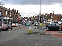
Church Road / Palatine Road junction, in central Northenden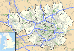
 Northenden
Northenden shown within Greater ManchesterOS grid reference SJ828901 - London 159 mi (256 km) SE Metropolitan borough Manchester Metropolitan county Greater Manchester Region North West Country England Sovereign state United Kingdom Post town MANCHESTER Postcode district M22 Dialling code 0161 Police Greater Manchester Fire Greater Manchester Ambulance North West EU Parliament North West England UK Parliament Wythenshawe and Sale East List of places: UK • England • Greater Manchester Northenden is a suburban area and electoral ward of the city of Manchester in North West England. It lies on the south side of both the River Mersey and the M60 motorway, 4.2 miles (6.8 km) west of Stockport and 5.2 miles (8.4 km) south of Manchester city centre. Northenden is bounded by the districts of Didsbury, Gatley and Wythenshawe on the north, east and southwest respectively. Northenden is within the postal area code and electoral boundaries of the Wythenshawe district.
Anciently a part of Cheshire, Northenden was formerly a rural township and parish within the hundred of Bucklow. Despite a process of unplanned urbanisation and population growth in its neighbours during the 19th century, Northenden remained a comparatively rural and unpopulated area which spanned the hamlets of Lawton Moor, Northern Moor, Rose Hill and a part of what is now Wythenshawe. By 1866 Northenden had coalesced and became a civil parish. The industrialisation of neighbouring Manchester resulted in overpopulation, and so in the early 20th century Manchester City Council used the Local Government Act 1929 to extend its boundaries to encompass Northenden in 1931.[1]
Throughout the mid-20th century Northenden was redeveloped as an overspill estate in southern Manchester.[1]
Contents
History
Further information: History of ManchesterNorthenden was mentioned as Norwordine in the Domesday Book of 1086; its name came from Anglo-Saxon Norþ-worþign = "north enclosure". It was then a small farming community with a manor house and woodland. Another theory is that the name means "northern dale or valley", presumably because it was near the River Mersey.[2] In later times Northenden was sometimes called Northen.
There was a weir on the Mersey there in the 14th century (where Mill Lane stands now) and a mill was set up to grind corn. The mill belonged to the Tatton family of Wythenshawe Hall, but was demolished in the 1960s.
As Northenden is on a major (and very old) crossing place of the Mersey on the "Salt Road" from Cheshire to Manchester, it prospered in medieval times. The ford was an important way into and out of and into Manchester (now Ford Lane), as there was no bridge over the Mersey between Sale and Stockport, until in 1745 Bonnie Prince Charlie's army built a troop-bridge out of big poplar tree trunks where the B5095 (Manchester Road, Didsbury) now crosses the Mersey, south of Didsbury, in his abortive attempt to seize the crown of England. The Northenden ford was unusual because its northern and southern ends were not opposite each other, but people using the ford had to wade about 500 feet along the riverbed. The Simon's Bridge was built at the ford in 1901 to help access to Poor's Field, and the rent from this field was used by the church to buy blankets and clothes for the needy.
Distance from Manchester enabled Northenden to avoid the Industrial Revolution in the 19th century. The nearest it came to industrialisation was a cottage industry in flax spinning. In the 1980s the area became part of the Mersey Valley Park, and the banks of the river form part of the Mersey Valley Trail.
Northenden began to develop as an attractive riverside township for Manchester's more affluent managers, clerks and tradesmen, and the Victorian and Edwardian development gives the village much of its present character. In the wake of Manchester's acquisition of Wythenshawe for a new Garden City. Northenden became an official district of Manchester in 1931.
Northenden is often referred to as a village by the locals, but was engulfed in suburban housing as the very large Wythenshawe housing estate was built during the first half of the 20th century. Northenden, whose centre was formerly Church Road, rapidly developed a new shopping centre along Palatine Road (a new road built to connect with Manchester) to service the new neighbourhood with shops, schools, a cinema (closed 1974), hotels, churches, small businesses and service industries. Eventually, a larger shopping centre and various amenities were built in the centre of Wythenshawe in the late 1960s, though Northenden still is busy.
Northenden railway station served the area between 1866 and 1964, being between Sharston Road and Longley Lane. Passenger trains from Stockport Tiviot Dale to Warrington and Liverpool stopped here.
Governance
Northenden was one of the eight ancient parishes of the Macclesfield Hundred of Cheshire and included the township of Northen Etchells. Under the Poor Law Amendment Act 1886 the parish was split in two as Northen Etchells became a civil parish in its own right. In 1931 both parishes were incorporated into the civil parish and city of Manchester, along with the civil parish of Baguley, which was part of the Bucklow Hundred of Cheshire.
Geography
Northenden is located in the southern end of the city of Manchester, 5.2 miles (8.4 km) from the city centre, and begins on the south bank of the River Mersey.
Northenden is now in a triangle formed by two motorways (the M56 and M60) and a main dual carriageway (Princess Parkway). Manchester Airport is approximately 4 miles to the south by road.
Northenden is part of the South Manchester district of Wythenshawe and is in the same postal area code and Parliamentary ward (Wythenshawe and Sale East). However, in 2006, after Manchester City Council erected a road sign that said "Welcome to Northenden, Wythenshawe", many Northenden residents protested the inclusion of the word "Wythenshawe". The residents were accused by one local councillor of snobbish behaviour and attempting to distance themselves from the Wythenshawe area (which is primarily social housing) for the sake of house prices as well as wanting to be seen more as an extension of the affluent neighbouring Didsbury area. The city council agreed to remove the word "Wythenshawe" from the sign, though Northenden still remains a part of the Wythenshawe area with the same postal area code and electoral boundaries.[3]
Places of interest
Church of St Wilfrid, Northenden is a Grade II* listed building. Most of the church's structure dates from the 19th century, apart from the tower which was built in the 15th century. The 19th century remodelling was done in red sandstone and is an example of Perpendicular Gothic architecture.[4] St Wilfrid's contains a memorial to 19th-century railway chairman Sir Edward Watkin, founder of the Channel Tunnel Company, who is buried in the church grounds.[5]
Northenden has the largest Jehovah's Witness Kingdom Hall in the area, a former cinema dating from the 1930s called the Forum.
The area also has places of worship for Methodists, Anglicans, Roman Catholics, Mormons and Quakers.
Northenden Social Club's first premises was a converted First World War army hut, originally used by the medical officer at Heaton Park. To buy it cost £114; the club had to find another £412 to pay for it to be transported to their site and set up as a social club. In front of the club is the Northenden War Memorial.
Notable people
Absalom Watkin (1787–1861). Born London. Manchester businessman and Liberal reformer. Rose Hill, a Grade II* listed Victorian villa off Longley Lane (now on Bronington Close) was built for him and his family. The property became a children's home for Manchester Corporation (now City Council) closing in the 1990s. The property became derelict until bought up (along with the grounds) in the late 1990s, subsequently refurbished as private apartments with the grounds being developed for private housing.
Sir Edward Watkin (1819–1901). Born in Salford. Victorian railway magnate and Channel Tunnel visionary lived at Rose Hill.
Public services
Northenden is covered by the South Manchester Division of Greater Manchester Police. The local Neighbourhood Policing Team is the Northenden Neighbourhood Policing Team, which covers Northenden, Brooklands and Baguley.
References
- ^ a b "Greater Manchester Gazetteer". Greater Manchester County Record Office. Places names - M to N. http://www.gmcro.co.uk/Guides/Gazeteer/gazzm2n.htm. Retrieved 17 October 2008.
- ^ "Northenden". Districts and Suburbs of Manchester. Manchester UK. http://www.manchester2002-uk.com/districts/northenden.html. Retrieved 2007-06-17.
- ^ South Manchester Reporter - article about Northenden/Wythenshawe road sign - 9 Feb 2006
- ^ "Church Of St Wilfrid, Manchester". Heritage Gateway website (Heritage Gateway (English Heritage, Institute of Historic Building Conservation and ALGAO:England)). 2006. http://www.heritagegateway.org.uk/Gateway/Results_Single.aspx?uid=388133&resourceID=5. Retrieved 22 November 2010
- ^ Elleray, Kirsty (4 December 2002). The nearly man of Northenden. Manchester Evening News. http://menmedia.co.uk/southmanchesterreporter/news/s/366967_the_nearly_man_of_northenden. Retrieved 22 November 2010
River Mersey
A section of the River Mersey is in the town of Northenden and one of its more popular parts is the weir, which now has a fish ladder so migrating salmon and sea trout can get upstream because the weir is flat with tiles and only a thin sheet of water running down the weir as it is fairly wide. Fishing can be very good here as this stretch contains trout, roach, dace, eels, pike, salmon (mid autumn-mid-spring and this goes for sea trout), chub, barbel and some grayling have been caught.
External links
- Northenden Civic Society
- St Wilfrid’s, Northenden (the locality: where it is, its history)
- Northenden Conservation Area
- Northenden Past
- Northenden Railway Station
- Northenden Riverside Park
- Northenden Mill
- Northenden Social Club history
The City of Manchester About Manchester Districts Ancoats · Ardwick · Ardwick Green · Baguley · Belle Vue · Benchill · Beswick · Blackley · Bradford · Burnage · Castlefield · Cheetham Hill · Chinatown · Chorlton-cum-Hardy · Chorlton-on-Medlock · Chorltonville · City Centre · Clayton · Collyhurst · Crumpsall · Didsbury · Fallowfield · Gay Village · Gorton · Harpurhey · Hulme · Levenshulme · Longsight · Lower Crumpsall · Miles Platting · Moss Side · Moston · Newall Green · New Islington · New Moston · Newton Heath · Northenden · Northern Moor · Northern Quarter · Openshaw · Peel Hall · Piccadilly Village · Ringway · Rusholme · Sharston · Spinningfields · Whalley Range · Withington · Woodhouse Park · WythenshaweCategories:- Greater Manchester articles needing cleanup
- Districts of Manchester
- Manchester City Council Wards


Wikimedia Foundation. 2010.