- Maritime Line
-
Maritime Line 280px
This mosaic at Falmouth Docks depicts the links
between the railway and the area's maritime heritageOverview Type Heavy rail System National Rail Status Open Locale Cornwall Termini Truro
50°15′50″N 5°03′54″W / 50.2640°N 5.0649°W
Falmouth Docks
50°09′03″N 5°03′21″W / 50.1508°N 5.0558°WStations 6 Operation Opened 1863 Owner Network Rail Operator(s) First Great Western Character Community rail Rolling stock Class 153 Technical Line length 11.75 miles (19 km) No. of tracks 1 Track gauge 4 ft 8 1⁄2 in (1,435 mm) Loading gauge RA6 / W7 Operating speed 50 mph (80 km/h) The Maritime Line is a railway line that runs in the valley of the River Fal from Truro (the county town) to Falmouth on the south coast of Cornwall, United Kingdom.
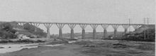
 A train crosses Carnon viaduct on its way towards Truro
 The original timber-built Carnon viaduct
Contents
History
The Maritime Line was built by the Cornwall Railway, a broad gauge railway 7 ft 0 1⁄4 in (2,140 mm) from Plymouth to Falmouth. The purpose of the scheme was to link London with Falmouth, from where packet ships sailed to destinations in Europe, Africa, and America.
The section from Plymouth to Truro opened on 4 May 1859, and the inhabitants of Falmouth soon put pressure on the company to extend the line to their town as originally intended. The extension opened on 24 August 1863 by which time the packet ships had been diverted elsewhere.[1]
After the West Cornwall Railway was converted to broad gauge in 1867 the Truro to Falmouth line tended to be operated as a branch, with the trains from London Paddington operating to Penzance instead.
The original stations on the line were at Truro, Perranwell (known as Perran until 19 February 1864), Penryn, and Falmouth (Now Falmouth Docks). Penmere was added on 1 July 1925, and Falmouth Town (originally known as The Dell) opened on 7 December 1970. the line terminated at the Dell for five years before reopening to the original terminus.
Great Western and BR
The Cornwall Railway was amalgamated into the Great Western Railway on 1 July 1889. Following the amalgamation, plans were put in place for conversion to standard gauge, which took place over the weekend of 21 May 1892. The Great Western Railway was nationalised into British Railways from 1 January 1948.
Privatisation
Britain's railways were privatised in the 1990s. At privatisation, the line was operated by Wales and West Train operating company for a few years until the company split. From 14 October 2001, the Maritime Line became the responsibility of Wessex Trains.
When the franchise became due for renewal, the tender was won by First Great Western and the company took over the operation on 1 April 2006.
Community rail
The Maritime Line is one of the railway lines supported by the Devon and Cornwall Rail Partnership, an organisation formed in 1991 to promote railway services in the area. The line is promoted by many means such as regular timetable and scenic line guides, as well as leaflets highlighting leisure opportunities such as walking, birdwatching, and visiting country pubs.
The Maritime Line rail ale trail was launched in 2003 to encourage rail travellers to visit pubs near the line. Of the 14 participating pubs, four are in Truro, one in Perranwell, three in Penryn, and six in Falmouth. 5, 10 or 14 stamps collected in the Rail Ale Trail leaflet entitle the participant to claim special Maritime Line Rail Trail souvenir merchandise.
Wessex Trains painted a Class 150 two-car DMU (number 150265) in coloured pictures promoting the line and named it The Falmouth Flyer. The unit continued in service with First Great Western when the company won the franchise but it has now been repainted in the standard fleet colours. While in the pictorial livery the worked throughout the southwest, not just on its named line.
The branch was designated by the Department for Transport as a community rail line in September 2006. This aims to increase the number of passengers and reduce costs. Strategies for investigation include more effective revenue collection, a passing loop, improved bus links, and working with ferry operators and colleges in the area.[2]
Improvements in 2009
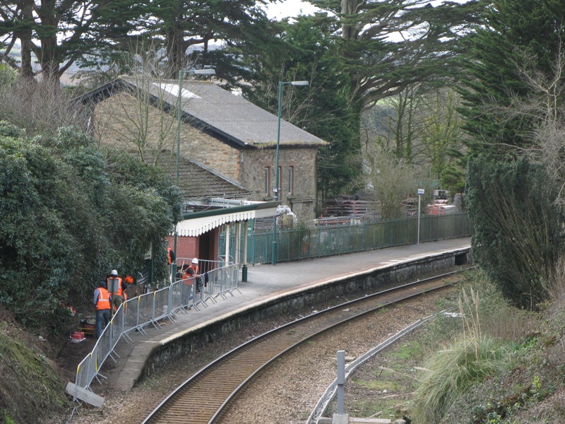
 Work underway at Perranwell to install signalling equipment for the new loop being installed at Penryn.
The line was originally dual track at Penryn, evidence of this can still be see at Penryn station, where two platforms are still visible. The Beeching Report in the 1960s instigated the reduction of the line here from two to one. In 2004 a proposal was put forward to reinstate a passing loop into the line, to allow for a doubling of service frequency.[3]. Funding was agreed with £4.67million coming from European Union funds, £2.5million from Cornwall Council, and £600,000 from Network Rail.[4] The new 400 metres (440 yd) loop was installed over two long weekends in October 2008 and work on the platform extension was also started.[5] The loop was brought into use ahead of schedule and to budget, with the formal opening by Kevin Lavery, the Chief Executive of Cornwall Council, taking place at Penryn station on 18 May 2009. Works included a new car park and waiting shelter at Penryn, in addition to the new loop, signalling and platform lengthening.[6]
Route
Maritime Line Legend

Cornish Main Line to London 
0.00 Truro 
Highertown Tunnel 

0.50 Penwithers Junction 


Newham branch 

Cornish Main Line to Penzance Sparnick Tunnel (491 yards) 


Carnon Viaduct above Redruth and Chasewater Railway 
4.25 Perranwell 
Perran Viaduct Perran Tunnel (374 yards) Ponsanooth Viaduct 8.25 Penryn Collegewood Viaduct 10.25 Penmere 11.25 Falmouth Town 11.75 Falmouth Docks 
Falmouth Docks (goods) Communities served
Truro – Perranarworthal – Penryn – Falmouth.
Description
Maritime Line trains start from Truro railway station, normally from the bay platform that is reached by turning left and walking along the main platform beyond the footbridge. The trains join the main line for the first half mile to Penwithers Junction, passing through the 70-yard (64 m)-long Higher Town Tunnel on the way. At this point the line to Penzance curves away to the right; the line to Falmouth was originally the Cornwall Railway main line and so runs straight ahead while the Penzance line was built by the West Cornwall Railway Company. The Maritime Line today only has a junction with the westbound track; trains running towards Truro do so on the "wrong" line which can be a bit disconcerting if a train from Penzance is arriving at the same time. The line from Penwithers to Falmouth Docks is single track, with the exception of the passing loop at Penryn.
From the tunnel the line emerges into the countryside outside Truro. The small excavated area of land on the left is a Local Nature Reserve which supports rare plants due to its unusual position in a triangle of rail routes - ours, the disused continuation of the West Cornwall Railway to the riverside at Newham, and a never-built route allowing Cornwall Railway trains to reach Newham. The route to Newham is now a cycle path round the edge of the city.
One and a half miles from the junction we enter Sparnick Tunnel which is a little over a quarter of a mile long. Although the line has only ever had a single track, most of the engineering, including the tunnels, was designed to carry a second one and this gives a spacious feel to the route.
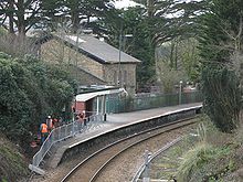
 Perranwell station
The line, which has been heading south-westwards, now swings around towards the south and passes high above the silted-up Restronguet Creek on Carnon viaduct. This valley was the route of the Redruth and Chasewater Railway down to quays at Devoran, about a mile beyond our viaduct. It is now part of the Mineral Tramway Trails.
Another half mile brings us to Perranwell railway station, nearly four miles from Truro. A modern shelter is situated on the platform, built in a style inspired by older railway buildings. As with all stations except for Truro, the platform is on our left as we travel towards Falmouth. In the forecourt is the old Cornwall Railway goods shed; a cast iron sign carrying the station name, and a dried up drinking fountain also hark back to earlier days.
The line now swings west, passes over the short Perran Viaduct and then south again along the hillside above Perranwell village before passing through the 374-yard (342 m)-long Perran Tunnel.
Turning south-eastwards, the line now passes over Ponsanooth Viaduct, the tallest on the line. Ponsanooth village is on the hillside to our right, while the River Kennal runs below to join up with Restronguet Creek.
 View of Penryn from the train.
The line passes beneath the A39 road from Truro to Falmouth at Treluswell, Four Cross, and then shortly enters Penryn which grew up at the head of a large inlet of the River Fal. Penryn railway station is at the top of the town, and we have views across the town to St Gulvias on the other side of the harbour. The station is eight and a quarter miles from Truro and has little of comment, but the platform shelter is identical to the one at Perranwell. Beyond the station the line passes over the Collegewood Viaduct . The last timber railway viaduct in Cornwall was here, but was replaced by this stone structure on 22 July 1934.
At Penryn there is a wide open space now occupied by Cornwall Motor Auctions. This was the goods yard where wagons were loaded and unloaded. There is also another - overgrown - platform visible on the other side of the train.
The line soon enters the outskirts of Falmouth. The town was established at the entrance to the inlet that leads to Penryn; it has now nearly spread to reach that town. Trains first call at the well-loved Penmere railway station, useful for people heading for the top of The Moor in the town centre, or for the newer western suburbs.
Passengers get a quick glimpse on their right of Falmouth Bay before trains call at the concrete platform of Falmouth Town railway station, which is nearer the National Maritime Museum, the waterside, and the shops.
It is now just a short distance to the terminus at Falmouth Docks railway station, 11.75 miles (18.91 km) from Truro. Falmouth Docks are below the station on the left, Pendennis Castle overlooks both these and the Gyllyngvase Beach on the other side of the line. Sidings serve the docks but are little used.
Passenger volume
The majority of passengers travel between Truro and the three stations in Falmouth, the busiest of which is Falmouth Town although passenger numbers at Falmouth Docks are increasing faster. Comparing the year from April 2008 to that which started in April 2002, passenger numbers at the Docks station have increased by 214% while those at the Town station have increased by 38% and at Penmere have increased by 42%.[7] The annual passenger usage is based on sales of tickets in stated financial years from Office of Rail Regulation statistics. The statistics are for passengers arriving and departing from each station and cover twelve month periods that start in April. Please note that methodology may vary year on year.
Station Name 2002-2003 2004-2005 2005-2006 2006-2007 2007-2008 2008-2009 2009-2010 Perranwell 11,110 9,936 9,545 10,489 9,842 13,348 17,658 Penryn 51,934 53,069 58,759 67,472 77,056 93,488 145,088 Penmere 67,460 71,676 76,571 75,572 79,227 95,842 132,726 Falmouth Town 80,377 85,859 83,899 89,787 91,638 111,012 140,798 Falmouth Docks 28,461 38,434 47,316 59,542 67,164 99,304 91,890 The statistics are for passengers arriving and departing from each station and cover twelve month periods that start in April.
Services
 150239 waits at Truro for passengers from the London train to join its service to Falmouth
Since the 1970s trains have only run between Falmouth Docks and Truro, where connections are made into services on the Cornish Main Line to Penzance, Plymouth and beyond. Trains run every thirty minutes for much of the day (except on Sundays when a less frequent service operates). They call at all stations except Perranwell which is served by alternate services on request to the guard or clear signal to the driver.[8]
Service in the 1960s was 16 or 17 trains daily, and had been reduced to 12 by 1975. By 2008 there were 13 trains each way, but with the new loop installed at Penryn the May 2009 timetable provides for 29. Trains are however usually only formed with one coach instead of the former two.[6]
References
- ^ Bennett, Alan (1988). The Great Western Railway in Mid Cornwall. Southampton: Kingfisher Railway Publications. ISBN 0-946184-53-4.
- ^ Department for Transport, Rail Group (2006), Route prospectus for the … The Maritime Line
- ^ Network Rail 2007 business plan
- ^ "Green light for Penryn loop". Modern Railways (Ian Allan Publishing) 65 (718): 9. 2008. ISSN 0026-8356.
- ^ "Penryn loop installed". Modern Railways (Ian Allan) 65 (722): 12. 2008. ISSN 0026-8356.
- ^ a b Heaps, Chris (2009). "New loop revitalises Falmouth branch". Modern Railways (Ian Allan Publishing) 66 (730): 16. ISSN 0026-8356.
- ^ "Station Usage". Rail Statistics. Office of Rail Regulation. http://www.rail-reg.gov.uk/server/show/nav.1529. Retrieved 2010-03-25.
- ^ "National Rail Timetable 143 (Summer 2009)" (PDF). Network Rail. http://www.networkrail.co.uk/browse%20documents/eNRT/May09/timetables/Table143.pdf. Retrieved 2009-05-11.
Further reading
- Bennett, Alan (1988). The Great Western Railway in Mid Cornwall. Southampton: Kingfisher Railway Publications. ISBN 0-946184-53-4.
- Binding, John (1993). Brunel's Cornish Viaducts. Atlantic Transport Publishing/Historical Model Railway Society. ISBN 0-906899-56-7.
External links
Railway lines in the South West Primary 
Secondary Local Atlantic Coast Line · Avocet Line · Bristol to Taunton Line · Cornish Main Line · Cotswold Line · Gloucester to Newport Line · Golden Valley Line · Heart of Wessex Line · Henbury Loop · Looe Valley Line · Lostwithiel to Fowey · Maritime Line · Portishead Branch · Riviera Line · Severn Beach Line · St Ives Bay Line · Tamar Valley Line · Tarka Line · Wessex Main LineHeritage Avon Valley Railway · Bristol Harbour Railway · Bodmin and Wadebridge Railway · Helston Railway · East Somerset Railway · Dartmoor Railway · Paignton and Dartmouth Steam Railway · South Devon Railway · West Somerset RailwayCategories:- Rail transport in Cornwall
- Scenic railway lines in Devon and Cornwall
- Community railway lines in the United Kingdom
- Railway lines in South West England
- Standard gauge railways in England
- 7ft gauge railways


Wikimedia Foundation. 2010.