- Geography of Grenada
-
Grenada Nickname: The Spice Isle 
Map of Grenada
Geography Location Caribbean Sea Coordinates 12°07′N 61°40′W / 12.117°N 61.667°W Archipelago Grenadines Area 310 km2 (120 sq mi) Length 19 km (11.8 mi) Width 34 km (21.1 mi) Coastline 121 km (75.2 mi) Highest elevation 840 m (2,760 ft) Highest point Mount St. Catherine Country GrenadaLargest city St. George's (pop. 7,500) Demographics Population 110,000 (as of 2005) Density 354.84 /km2 (919.03 /sq mi) Ethnic groups Blacks 82% Mulatto 12% South Asians (Indo-Grenadians) 3% and whites 2.9%, trace Arawak/Carib Amerindian 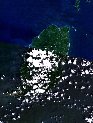 Grenada - NASA NLT Landsat 7 (Visible Color) Satellite Image
This article describes the geography of Grenada.
Grenada is a Caribbean island (one of the Grenadines) between the Caribbean Sea and Atlantic Ocean, north of Trinidad and Tobago. It is located at 12°07′N 61°40′W / 12.117°N 61.667°W. There are no large inland bodies of water on the island, which consists entirely of the state of Grenada. The coastline is 121 km long.
Grenada has 15 constituencies and speaks English. It is volcanic in origin and its topography/land scape is mountainous.
Natural resources include timber, tropical fruit and deepwater harbors.
Grenada and its largely uninhabited outlying territories are the most southerly of the Windward Islands. The Grenadine Islands chain consists of some 600 islets; those south of the Martinique Channel belong to Grenada, while those north of the channel are part of the nation of St. Vincent and the Grenadines. Located about 160 kilometers north of Venezuela, at approximately 12° north latitude and 61° west longitude, Grenada and its territories occupy a total area of 433 square kilometers. Grenada, known as the Spice Isle because of its production of nutmeg and mace, is the largest at 310 square kilometers, or about the size of Detroit. The island is oval shape and framed by a jagged southern coastline; its maximum width is thirty-four kilometers, and its maximum length is nineteen kilometers. St. George's, the capital and the nation's most important harbor, is favorably situated near a lagoon on the southwestern coast. Of all the islands belonging to Grenada, only two are of consequence: Carriacou, with a population of a few thousand, and its neighbor Petit Martinique, roughly 40 kilometers northeast of Grenada and populated by some 700 inhabitants.
Part of the volcanic chain in the Lesser Antilles arc, Grenada and its possessions generally vary in elevation from under 300 meters to over 600 meters above sea level. Grenada is more rugged and densely foliated than its outlying possessions, but other geographical conditions are more similar. Grenada's landmass rises from a narrow, coastal plain in a generally north-south trending axis of ridges and narrow valleys. Mount St. Catherine is the highest peak at 840 meters.
Although many of the rocks and soils are of volcanic origin, the volcanic cones dotting Grenada are long dormant. The only known active volcano in the area is Kick_'em_Jenny, just north between Grenada and Carriacou. Some of the drainage features on Grenada remain from its volcanic past. There are a few crater lakes, the largest of which is Grand Etang. The swift upper reaches of rivers, which occasionally overflow and cause flooding and landslides, generally cut deeply into the conic slopes. By contrast, many of the water courses in the lowlands tend to be sluggish and meandering.
Climate
The Grenadan climate is tropical, tempered by northeast trade winds. The land is volcanic in origin with mountains in the interior. The lowest point is at sea level, and the highest is 840 m (2,756 ft) on Mount Saint Catherine.
The abundance of water is primarily caused by the tropical, wet climate. Yearly precipitation, largely generated by the warm and moisture-laden northeasterly trade winds, varies from more than 3,500 millimeters (137.8 in) on the windward mountainsides to less than 1,500 millimeters (59.1 in) in the lowlands. The greatest monthly totals are recorded throughout Grenada from June through November, the months when tropical storms and hurricanes are most likely to occur. Rainfall is less pronounced from December through May, when the equatorial low-pressure system moves south. Similarly, the highest humidities, usually close to 80 percent, are recorded during the rainy months, and values from 68 to 78 percent are registered during the drier period. Temperatures averaging 29 °C (84.2 °F) are constant throughout the year, however, with slightly higher readings in the lowlands. Nevertheless, diurnal ranges within a 24-hour period are appreciable: between 26 and 32 °C (78.8 and 89.6 °F) during the day and between 19 and 24 °C (66.2 and 75.2 °F) at night.
Statistics
- Area
-
- Total: 340 km²
- Land: 340 km²
- Maritime claims
-
- Exclusive economic zone: 200 nmi (370.4 km; 230.2 mi)
- Territorial sea: 12 nmi (22.2 km; 13.8 mi)
- Land use
-
- Arable land: 15%
- Permanent crops: 18%
- Permanent pastures: 3%
- Forests and woodland: 9%
- Other: 55% (1993 est.)
- Irrigated land
- NA km²
- Natural hazards
- Lies on edge of hurricane belt; hurricane season lasts from June to November
- Environment - current issues
- NA
- Environment - international agreements
- Party to: Biodiversity, Climate Change, Desertification, Endangered Species, Law of the Sea, Ozone Layer Protection, Whaling
- Geography - note
- The administration of the islands of the Grenadines group is divided between Saint Vincent and the Grenadines (northern Grenadines) and Grenada (southern Grenadines)
References
 This article incorporates public domain material from websites or documents of the Library of Congress Country Studies.
- This article incorporates public domain material from websites or documents of the CIA World Factbook.
Sovereign states Antigua and Barbuda · Bahamas · Barbados · Belize · Canada · Costa Rica · Cuba · Dominica · Dominican Republic · El Salvador · Grenada · Guatemala · Haiti · Honduras · Jamaica · Mexico · Nicaragua · Panama · Saint Kitts and Nevis · Saint Lucia · Saint Vincent and the Grenadines · Trinidad and Tobago · United States
Dependencies and
other territoriesAnguilla · Aruba · Bermuda · Bonaire · British Virgin Islands · Cayman Islands · Curaçao · Greenland · Guadeloupe · Martinique · Montserrat · Navassa Island · Puerto Rico · Saint Barthélemy · Saint Martin · Saint Pierre and Miquelon · Saba · Sint Eustatius · Sint Maarten · Turks and Caicos Islands · United States Virgin Islands
Climate of North America Sovereign states Antigua and Barbuda · Bahamas · Barbados · Belize · Canada · Costa Rica · Cuba · Dominica · Dominican Republic · El Salvador · Grenada · Guatemala · Haiti · Honduras · Jamaica · Mexico · Nicaragua · Panama · Saint Kitts and Nevis · Saint Lucia · Saint Vincent and the Grenadines · Trinidad and Tobago · United States
Dependencies and
other territoriesAnguilla · Aruba · Bermuda · Bonaire · British Virgin Islands · Cayman Islands · Curaçao · Greenland · Guadeloupe · Martinique · Montserrat · Puerto Rico · Saint Barthélemy · Saint Martin · Saint Pierre and Miquelon · Saba · Sint Eustatius · Sint Maarten · Turks and Caicos Islands · United States Virgin Islands
Categories:


Wikimedia Foundation. 2010.