- Bankstown Bunker
-
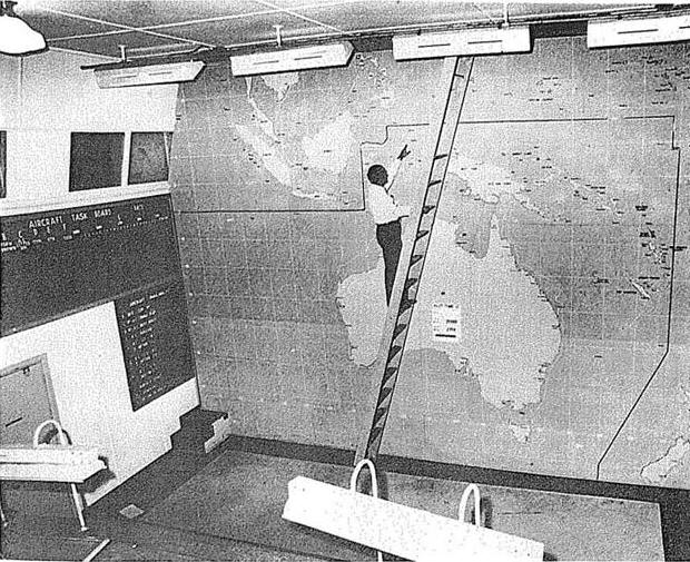
 Bankstown bunker in 1945
The Bankstown Bunker (Air Defence Headquarters Sydney) is a disused RAAF operations facility, located on the corner of Marion and Edgar Street, Bankstown, New South Wales.
After the arrival of General Douglas MacArthur in Australia during the Second World War, Bankstown Airport was established as a key strategic air force base to support the war effort. During this period the specially constructed bunker became an important Royal Australian Air Force headquarters from 1945 until its closure in 1947.[1] The Bankstown bunker is currently buried under a public park which lies at the end of Taylor Street.[2][3]
Contents
History
 The Bankstown Bunker during World War II
 The before and after. The same room as it is today, after a fire destroyed it in 1972
During the Second World War from 1945 to 1947 the Bankstown bunker was utilised as a covert Royal Australian Air force base. Construction of the facility commenced in late 1942 at a cost of £30,579 with its official commissioning in January 1945 as the headquarters for No. 1 Fighter Sector RAAF. This unit had previously operated from the Capital Hall picture theatre in Bankstown and a tunnel under the St. James Railway station.[4]
The primary use of the Sydney Air Defence Headquarters was the location, tracking and interception of all planes in the eastern area of the South West Pacific. It was the heart of the Australian defence network, where, in co-operation with the highest officers of Navy and Army, Australian bombers and fighters were controlled in defence and attack against the enemy from this location.
The bunker was manned at all times in shifts that the Air Force called "Flights". Most of the personnel that worked in the bunker were local. Even so, the Air Force provided accommodation for them in Chapel Road, Bankstown whilst buses with blacked out windows transported military personnel to the bunker. All staff for the bunker had to undergo special training, including 'plane identification' training that also took place at Chapel Road.
The bunker was manned by members of the No.2 Volunteer Air Observer Corps, the Women's Auxiliary Australian Air Force, members of the Royal Australian Air Force and the United States Army Air Forces.[5]
A transmitting station for the bunker was located in Johnston Road, Bass Hill and was a building of above ground construction.[6]
The bunker appears to have been decommissioned when the ADHQ was disbanded in 1947.[7] A caretaker was then assigned to the take care of the bunker.
It wasn't until 1971 that members of No. 2 Stores Depot RAAF in Regents Park invited the then editor of Bankstown's Torch Newspaper, Phil Engisch [8] into the bunker. Many photos were taken and an article was placed in local newspapers detailing the find. In 1972, arsonists set the bunker on fire. In 1976 the NSW Department of Housing acquired the land the bunker is built under and redeveloped the area into the townhouses that now cover most of the site. The area now comprises a number of separate complexes or "Closes" containing eight to eleven villas. Each Close is named appropriately after a type of aeroplane that flew from Bankstown during the Second World War.
Inside the bunker
The Bankstown Bunker is of similar design to the underground Ops rooms of wartime England, which directed Britain's air defence fighter plane attacks on the invading German Luftwaffe. Entrance to the bunker was obtained through a concrete passageway which was well screened by a grassy slope, a stairway led to a virtual maze of corridors and hallways leading to various sections.[9]
 Inside one of the bunker hallways
The walls of the bunker were 1.5 metres thick[10] and it could almost withstand a direct hit from a 300 lb (140 kg) bomb. It had all the attenuated fixtures necessary to run a top secret operational defence base. It consisted of three Fixer Stations and one Homing Station. There were switchboards directing up to fifty telephone lines that went to various locations including radar stations and VAOC lookout posts which reported aircraft locations to the bunker. The bunker was also equipped with its own code room, plotting rooms, two escape tunnels and a radio transmitter room. In the centre of the bunker was a large room of about two-stories in height. This was the main Ops room and control centre for all RAAF Missions in the Pacific area.[11] The room also had a large map, (24' x 18') denoting troop positions in the South West Pacific theater of World War II.
The facilities inside the bunker also had to cater for the full time staff who lived and worked in the facility, working on a rotating roster that involved living in the bunker for two-week periods. The living quarters consisted of its own kitchen, dining area, bathrooms and bedrooms. The bunker also had its own generator and air conditioning. [12]
There are rumors of a tunnel running from the bunker to an unknown location.[13]
Location
There is a small reserve between the town houses at the end of Taylor Street. It is under this hill that the bunker has been buried. The entrance to the bunker has now been sealed and the area over the top of the bunker has been landscaped to conceal its position, to the point that it is completely undetectable from the street.
Other bunkers in the City of Bankstown
 The remote receiving station. Map date 17 February 1942.
 Chullora Railway Workshops and former site of WWII manufacturing plant.
There is one other confirmed bunker, a "Remote Receiving station", in Bankstown.[14] Little is known about its history though it was reportedly "heavily vandalised" in 1945. It was located in Picnic Point National Park, near the South Sydney Power station.[15] According to residents of the area, it still exists. Based on a comparison of contemporary and historic maps, the Receiving Station and the present day Sydney South electricity substation share the same footprint, with the latter apparently situated directly above the former. The substation is bounded on its southwestern and southeastern sides by Henry Lawson Drive, in the Georges River National Park. It is alleged that there are several other bunkers in the Bankstown area, such as under an electricity block house on the corner of Milperra road and Henry Lawson Drive, and a demolished bunker under Condell Park High School.
During World War II, Bankstown was a hive for military activity. Bankstown Airport was home to several fighter units and several "dummy houses" existed in and around Bankstown Airport. These houses were built to make Bankstown Airport and its surrounds appear as a farm. Military personnel who worked in Bankstown lived in the area around Chapel Road (where Paul Keating Park and the council chambers are located today). Training facilities for the various plotting rooms around Sydney were also located in the area.
During World War II a major wartime manufacturing plant was located in Chullora. The site once occupied 100 acres (400,000 m2) of land surrounded by Rookwood Cemetery, Brunker Road, the Hume Highway and Centenary Drive. The site was said to have been the largest secret manufacturing plant in Australia which was used for the production of military weapons, plane components, tanks, and ordnance. Over two-thousand men and woman were employed to work at the factory on a daily basis. During the war the factory produced components for 700 Beaufort, 380 Beaufighter and up to 50 Lincoln aircraft. Over 54 ACI tanks were built as well as 60 General Lee tanks that were adapted for use in the Australian Military, as were local jeeps in the 70s. The factory also produced 81 cupola turrets for the British Matilda tanks.[16][17]
An underground "bunker" and tunnel system is apparently located on this site. It is directly under a block flats in Davidson Street and Marlene Crescent. The entrance to the "bunker" is by steel doors set in concrete into the hillside in a railway cutting which runs from alongside the railway line parallel to Marlene Crescent at a platform called the Railwelders and which leads under the block of flats. The doors to this "bunker" were welded up in the late 1980s. The ventilation shafts that were once visible from the Hume Highway have been removed.
Apart from the bunker, there is also a network of storage facilities that extend under the railway workshop. Sometime between 1977 to 1978 the steel access doors were fitted with locks (Railway SL type). The steel access doors were bolted into the side of a stormwater drain which runs along the old RTA building in Chullora, then under the Hume Hwy and eventually under the rail workshop. It has also been alleged that a tunnel approximately four miles long connects this complex with the Bankstown Bunker.[18]
Burke's Backyard
The Bankstown Bunker was on an episode of Burke's Backyard. Don Burke conducted part of the show from inside the bunker. To enter the bunker he had to crawl in through an air vent.[19][20]
References
- ^ Maltby, Kathy; Rosen, Sue – Bankstown: Sense of Identity. From Settlement to City. Civic Tower 66-72 Rickard Road Bankstown: Bankstown City Council. pp. Pages 13.
- ^ Veitch, Alen (24 June 1971 page 12-13). "The Bankstown Bunker". Australian Post.
- ^ Images of the Bankstown Bunker located in Condell Park.
- ^ Stevenson, Clare; Darling, Honor, eds. The W.A.A.A.F Book. Peter Dunn. http://www.sandgate.net/~dunn/raaf/1fshq.htm. Retrieved 18 October 2007.
- ^ http://westernsydneybunkers.webs.com/bankstownbunker.htm
- ^ W/T. Transmit. Stn. of Bankstown, N.S.W.. National Archives of Australia. http://naa12.naa.gov.au/scripts/imagine.asp?B=3284735&I=1&SE=1.
- ^ (National Archives of Australia document 151/2/1098)
- ^ History
- ^ (information supplied by R. Eyers VAOC worker)
- ^ Teenagers raid bunker. BunkerBoyz.org. http://www.bunkerboyz.org/bankbunk2.htm.
- ^ http://www.sydneyarchitecture.com/SUB/SUB-09.htm
- ^ Lawrence, Joan.; Brian Madden and Lesliie Muir. (September. 1999). http://www.kingsclearbooks.com.au/cb.html Pictorial History of Canterbury Bankstown.. Kingsclear Books. pp. 89. ISBN 0-908272-55-3..
- ^ Peters, Merle (20 January 1993). "Historian's account". Bankstown Torch Newspaper.
- ^ Bankstown Remote Receiving Building, Bankstown, New South Wales, during WW2
- ^ see map - Image:Bankstown01.jpg
- ^ Lawrence, Joan; Brian Madden and Leslie Muir (1999). A Pictorial History of Canterbury Bankstown. Alexandria, New South Wales: Kingsclear Books. pp. 91–92. ISBN 0-908272-55-3. http://www.kingsclearbooks.com.au/cb.html.
- ^ Chullora "Bunker" and underground Tunnels. Were they used during WW2?
- ^ http://westernsydneybunkers.webs.com/chulloramunitionssite.htm
- ^ Video available from Bankstown Library, Local Studies collection, level 3
- ^ Treseder, Peter (January - March). "Backyard adventure uncovers a wartime secret". Australian Geographic: pp. Pages 17–18. http://editorial.australiangeographic.com.au/.
External links
- Bankstown Bunker is at coordinates 33°55′03″S 151°00′54″E / 33.917610°S 151.014900°ECoordinates: 33°55′03″S 151°00′54″E / 33.917610°S 151.014900°E
Barracks, batteries, bunkers and forts, Sydney and surrounds City of Sydney Greater Western and South Western Sydney Bankstown Bunker · Camp Warwick · Holsworthy Barracks · Ingleburn Army Camp · Wallgrove Army Base · 118th General HospitalLa Perouse and Malabar Mosman and Manly Beehive Casemate · Bradleys Head Fortification Complex · Georges Head Battery · Lower Georges Heights Commanding Position · Middle Head Fortifications · Shelly Battery · Sydney Harbour anti-submarine boom netWatsons Bay, Vaucluse and North Bondi Ben Buckler Gun Battery · Anti-motor torpedo boat defensive battery · Steel Point Battery · Signal Hill BatteryCity of Wollongong See also Categories:- Military history of Australia during World War II
- Bunkers
- 1945 establishments
- Royal Australian Air Force
- Military history of Sydney during World War II
- City of Bankstown


Wikimedia Foundation. 2010.