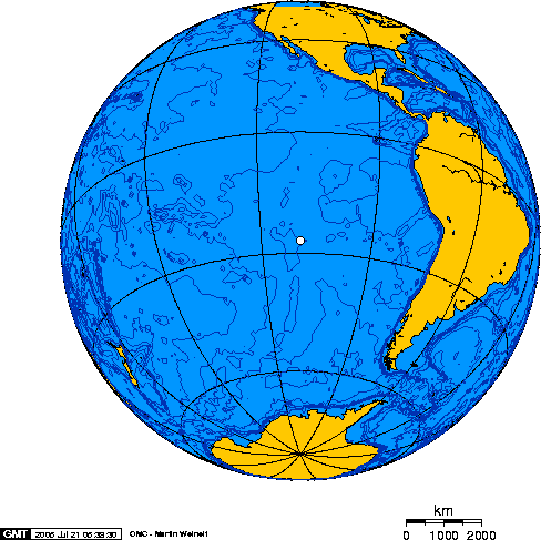
Moai (seamount)

Moai (seamount)
Moai
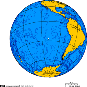
Orthographic projection centered on Easter Island
Height >2,500 metres
Location
Location Pacific Ocean, west of Easter Island
Geology
Type Submarine volcano
Volcanic arc/chain Sala y Gómez ridge
Age of rock Pleistocene
Last eruption >100,000 BCE

The Moai Seamount is a submarine volcano, the second most westerly in the Easter Seamount Chain or Sala y Gómez ridge. It is east of Pukao seamount and west of Easter Island. It rises over 2,500 metres from the ocean floor to within a few hundred metres of the sea surface.[1] The Moai seamount is fairly young, having developed in the last few hundred thousand years as the Nazca Plate floats over the Easter hotspot.

The Moai seamount was named after the moai statues of neighbouring Easter Island.

See also

References


Wikimedia Foundation. 2010.

Игры ⚽ Поможем решить контрольную работу

Look at other dictionaries:

  • Moai — For the seamount, see Moai (seamount). Moai facing inland at Ahu Tongariki, restored by Chilean archaeologist Claudio Cristino in the 1990s Moai …   Wikipedia

  • Pukao (seamount) — Infobox Seamount Name=Pukao Seamount Photo= Caption= Depth=Below Sea level Height=2500+ m Location= west of Easter Island Range= Prominence = Coordinates = Topographic Type=Submarine volcano Volcanic Arc/Belt=Sala Y Gomez ridge Age=Pleistocene… …   Wikipedia

  • Easter Island — For the album by Kris Kristofferson, see Easter Island (album). Rapa Nui redirects here. For other uses, see Rapa Nui (disambiguation). Coordinates: 27°7′S 109°22′W /  …   Wikipedia

  • Liste des monts sous-marins de l'océan Pacifique — En raison de l intense activité volcanique et tectonique de cette partie du monde, un part significative des monts sous marins connus dans le monde sont situés dans l océan Pacifique, souvent isolés, parfois groupés comme les monts sous marins de …   Wikipédia en Français

  • Orongo — ‘Orongo is a stone village and ceremonial centre at the southwestern tip of Rapa Nui (Easter Island). The first half of the ceremonial village s 53 stone masonry houses were investigated and restored in 1974 by American archaeologist William… …   Wikipedia

  • Music of Easter Island — Traditional musical dance of Rapa Nui (Easter Island). Easter Island is located in the Pacific Ocean. Though its earliest inhabitants are ethnically Polynesian, the island is part of the South American state of Chile. History Traditional music… …   Wikipedia

  • Decipherment of rongorongo — Tablet B Aruku kurenga, verso. One of four texts which provided the Jaussen list, the first attempt at decipherment. Made of Pacific rosewood, mid nineteenth century, Easter Island. (Collection of the SS.CC., Rome) There have been numerous… …   Wikipedia

  • Easter hotspot — The Easter hotspot is a volcanic hotspot located in the southeastern Pacific Ocean. The hotspot created the Sala y Gómez Ridge which includes Easter Island and the Pukao Seamount which is at the ridges s young western edge.ee also* Easter… …   Wikipedia

  • Geology of Chile — The Geology of Chile is mainly a product of the the Andean orogeny which in turn is caused by the subduction zone at at its coast. This subduction have shaped two other features parallel to the Andes, the Intemidiate Depression which is a… …   Wikipedia

  • Isla Salas y Gómez — [ [http://www.ine.cl/canales/chile estadistico/demografia y vitales/demografia/pdf/cdpubaldcasjunio2005.zip Chile: Ciudades, Pueblos, Aldeas y Caseríos 2005] , Instituto Nacional de Estadísticas June 2005.] , also known as Isla Sala y Gómez, is a …   Wikipedia

Share the article and excerpts

Direct link
Do a right-click on the link above
and select “Copy Link”