- Dunkery Beacon
-
Dunkery Beacon 
Dunkery Beacon seen on the ascent up the western slopesElevation 1,705 ft (520 m) Prominence 414 m (1,358 ft) Parent peak High Willhays Listing Marilyn, County Top Location Exmoor, England
 Dunkery Beacon
Coordinates 51°09′43″N 3°35′14″W / 51.16197°N 3.58736°WCoordinates: 51°09′43″N 3°35′14″W / 51.16197°N 3.58736°W Topo map OS Landranger 181 OS grid SS891415 Dunkery Beacon is the summit of Dunkery Hill, and the highest point on Exmoor and in Somerset, England.[1] It is also the highest point in southern England outside Dartmoor.
The site is part of the North Exmoor Site of Special Scientific Interest (SSSI), is part of the Dunkery & Horner Woods National Nature Reserve[2] and is a candidate for Special Area of Conservation, Section 3 Moor and Heath and Common Land status.[3]
Contents
History
Dunkery is composed of Devonian sedimentary rock, as can be seen in the red soil.[3]
There are several Bronze Age burial mounds at or near the summit: two of the larger ones are Joaney How and Robin How. However these have been damaged over many years and plans have been made to restore and protect them.[3]
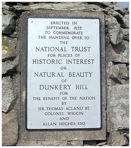
Dunkery Beacon was given to the National Trust in 1935 by Sir Thomas Acland, Colonel Wiggin and Allan Hughes along with the rest of the Holnicote Estate an event commemorated by the summit memorial cairn.
Location
At 1,705 feet (520 m) Dunkery Beacon is the highest geographical point in Somerset,[1] although the tip of the Mendip TV Mast is higher above sea level at 1,924 feet (586 m). Based on the formula 'distance of hill from its nearest higher neighbour in km squared, multiplied by its height in metres', Dunkery is ranked 23rd in the UK in terms of dominance, and is a Marilyn. The nearest higher hill is Yes Tor 37 miles (60 km) away.
It lies just 4 miles (6.4 km) from the Bristol Channel at Porlock. The shortest route of ascent goes from the car park at Dunkery Gate, and is just 0.75 miles (1.2 km) long. There are extensive views from the summit, including both the Bristol and English Channel coasts, the Brecon Beacons including Pen Y Fan, Bodmin Moor, Dartmoor, the Severn Bridges and Cleeve Hill 86 miles (138 km) away in Gloucestershire.
Ecology
The hill is blanketed in heather and in the summer this gives it a deep purple colour. Ling and bell heather, gorse, sessile oak, ash, rowan, hazel, bracken, mosses, liverworts, lichens and ferns all grow here or in surrounding woodland, as well as some unique whitebeam species. Exmoor ponies, red deer, pied flycatchers, wood warblers, lesser spotted woodpeckers, redstarts, dippers, snipe, skylarks and kestrels are some of the fauna to be found here and in nearby Horner Woods. Horner Woods are also the home to 14 of the 16 UK bat species, which include barbastelle and Bechstein's bats.
In the media
In Lorna Doone, John Fry calls it the "haighest place of Hexmoor".
Gallery
-
The National Trust plaque on the summit
-

Dunkery Hill
-

Heather in flower on Dunkery Beacon
-

Clouds flowing over Dunkery Hill
-

Dunkery ridge from Wilmersham Common
References
- ^ a b "Moor Facts". Exmoor National Park. http://www.exmoor-nationalpark.gov.uk/index/learning_about/moor_facts.htm. Retrieved 2007-11-28.
- ^ "Dunkery & Horner Woods NNR". Special Sites. Natural England. http://www.naturalengland.org.uk/ourwork/conservation/designatedareas/nnr/1006951.aspx. Retrieved 2010-01-31.
- ^ a b c "Planning Committee". Exmoor National Park. 2004-07-08. http://www.exmoor-nationalpark.gov.uk/cpa-6.8.04.110.pdf. Retrieved 2008-07-03.
External links
- A computer generated 360 degree summit panorama from the top of Dunkery Beacon index
Categories:- Marilyns of England
- Hills of Somerset
- Exmoor
- National Nature Reserves in England
-


Wikimedia Foundation. 2010.