- Compass navigation system
-
For navigation with a magnetic compass, see compass.
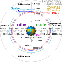 Comparison of GPS, GLONASS, Galileo and Compass (medium earth orbit) satellite navigation system orbits with the International Space Station, Hubble Space Telescope and Iridium constellation orbits, Geostationary Earth Orbit, and the nominal size of the Earth. The Moon's orbit is 9.1 times larger (in radius and length) than geostationary orbit.[1]
The COMPASS system (also known as Beidou-2, BD2) is a project by China to develop an independent global satellite navigation system. [2]
COMPASS is not an extension to the previously deployed Beidou-1, but a new GNSS similar in principle to GPS, GLONASS, and Galileo.
Contents
General
The new system will be a constellation of 35 satellites, which include 5 geostationary orbit (GEO) satellites and 30 medium Earth orbit (MEO) satellites, that will offer complete coverage of the globe. The ranging signals are based on the CDMA principle and have complex structure typical to Galileo or modernized GPS. Similarly to the other GNSS, there will be two levels of positioning service: open and restricted (military). The public service shall be available globally to general users. When all the currently planned GNSS systems are deployed, the users will benefit from the use of a total constellation of 75+ satellites, which will significantly improve all the aspects of positioning, especially availability of the signals in so-called “urban canyons”.[3] The general designer of Compass navigation system is Sun Jiadong, who is also the general designer of its predecessor, Beidou navigation system.
 Frequency allocation of GPS, Galileo, and Compass; the light red color of E1 band indicates that the transmission in this band has not yet been detected
Frequencies for Compass are allocated in four bands: E1, E2, E5B, and E6 and overlap with Galileo. The fact of overlapping could be convenient from the point of view of the receiver design, but on the other hand raises the issues of inter-system interference, especially within E1 and E2 bands, which are allocated for Galileo’s publicly-regulated service.[4] However, under International Telecommunications Union (ITU) policies, the first nation to start broadcasting in a specific frequency will have priority to that frequency, and any subsequent users will be required to obtain permission prior to using that frequency, and otherwise ensure that their broadcasts do not interfere with the original nation's broadcasts. It now appears that Chinese Compass satellites will start transmitting in the E1, E2, E5B, and E6 bands before Europe's Galileo satellites and thus have primary rights to these frequency ranges.[5]
Although almost nothing has yet been officially announced by Chinese authorities about the signals of the new system, the launch of the first Compass satellite permitted independent researchers not only to study general characteristics of the signals but even to build a Compass receiver.
Compass-M1
Compass-M1 is an experimental satellite launched for signal testing and validation and for the frequency filing on April 14, 2007. The role of Compass-M1 for Compass is similar to the role of GIOVE satellites for Galileo. The signals of Compass-M1 are to a great extent unraveled by independent research. The orbit of Compass-M1 is nearly circular, has an altitude of 21,150 km and an inclination of 55.5 degrees.
Compass-M1 is transmitting in 3 bands: E2, E5B, and E6. In each frequency band two coherent sub-signals have been detected with a phase shift of 90 degrees (in quadrature). These signal components are further referred to as “I” and “Q”. The “I” components have shorter codes and are likely to be intended for the open service. The “Q” components have much longer codes, are more interference resistive, and are probably intended for the restricted service.
The investigation of the transmitted signals started immediately after the launch of COMPASS-M1 on April 14, 2007. Already in June engineers at CNES reported the spectrum and structure of the signals.[6] Next month researchers from the Stanford University reported complete decoding of the “I” signal scomponents.[7][8] The knowledge of the codes allowed a group of engineers at Septentrio to build the COMPASS receiver[9] and report tracking and multipath characteristics of the “I” signals on E2 and E5B.[10]
Characteristics of COMPASS signals reported as of May 2008 compared to GPS-L1CA Parameters E2-I E2-Q E5B-I E5B-Q E6-I E6-Q GPS L1-CA Native notation B1 B1 B2 B2 B3 B3 --- Code modulation BPSK(2) BPSK(2) BPSK(2) BPSK(10) BPSK(10) BPSK (10) BPSK (1) Carrier frequency, MHz 1561.098 1561.098 1207.14 1207.14 1268.52 1268.52 1575.42 Chip rate, Mchips/sec 2.046 2.046 2.046 10.230 10.230 10.230 1.023 Code period, chips 2046 ?? 2046 ?? 10230 ?? 1023 Code period, msec 1.0 >400 1.0 >160 1.0 >160 1.0 Symbols/sec 50 ?? 50 ?? 50 ?? 50 Navigation frames, sec 6 ?? 6 ?? ?? ?? 6 Navigation sub-frames, sec 30 ?? 30 ?? ?? ?? 30 Navigation period, min 12.0 ?? 12.0 ?? ?? ?? 12.5 Characteristics of the “I” signals on E2 and E5B are generally similar to the civilian codes of GPS (L1-CA and L2C), but Compass signals have somewhat greater power. The notation of Compass signals used in this page follows the naming of the frequency bands and agrees with the notation used in the American literature on the subject, but the notation used by the Chinese seems to be different and is quoted in the first row of the table.
Compass launches
Mission Date[11] Name Launch center Launch vehicle Bus Orbit 07-32 2007.04.13 Compass-M1 Xichang CZ-3C DFH-3 MEO ~21,500 km 07-37 2009.04.14 Compass-G2 Xichang CZ-3C DFH-3 GEO drifting 07-38 2010.01.16 Compass-G1 Xichang CZ-3C DFH-3 GEO 144.5°E 07-39 2010.06.02 Compass-G3 Xichang CZ-3C DFH-3 GEO 84.0°E 07-40 2010.07.31 Compass-IGSO1 Xichang CZ-3A DFH-3 HEO ~36,000 km 07-43 2010.10.31 Compass-G4 Xichang CZ-3C DFH-3 GEO 160.0°E 07-45 2010.12.17 Compass-IGSO2 Xichang CZ-3A DFH-3 HEO ~36,000 km 07-46 2011.04.10 Compass-IGSO3 Xichang CZ-3A DFH-3 HEO ~36,000 km 07-49 2011.07.27 Compass-IGSO-4 Xichang CZ-3A DFH-3 HEO ~36,000 km References
- ^ Orbital periods and speeds are calculated using the relations 4π²R³ = T²GM and V²R = GM, where R = radius of orbit in metres, T = orbital period in seconds, V = orbital speed in m/s, G = gravitational constant ≈ 6.673×10⁻¹¹ Nm²/kg², M = mass of Earth ≈ 5.98×1024 kg.
- ^ "Compass due Next year". Magazine article. Asian Surveying and Mapping. May 1, 2009. http://www.asmmag.com/news/compass-due-next-year. Retrieved 2009-05-05.[dead link]
- ^ G. Gibbons. China GNSS 101. Compass in the rearview mirror. InsideGNSS, January/February 2008, p. 62-63 [1]
- ^ Galileo, Compass on collision course, GPS World, April 2008, p. 27
- ^ Chinese square off with Europe in space
- ^ T. Grelier, J. Dantepal, A. Delatour, A. Ghion, L. Ries, Initial observation and analysis of Compass MEO satellite signals, Inside GNSS, May/June 2007 [2]
- ^ G. Xingxin Gao, A. Chen, S. Lo, D. De Lorenzo, P. Enge, GNSS over China. The Compass MEO satellite codes. Inside GNSS, July/August 2007, pp. 36-43 [3]
- ^ G. Xingxin Gao, A. Chen, Sh. Lo, D. De Lorenzo and Per Enge, Compass-M1 broadcast codes and their application to acquisition and tracking, Proceeedings of the ION National Technical Meeting 2008, San Diego, California, January 2008.[4]
- ^ W. De Wilde, F. Boon, J.-M. Sleewaegen, F. Wilms, More Compass points. Tracking China’s MEO satellite on a hardware receiver. Inside GNSS, July/August 2007, pp. 44-48. [5]
- ^ A. Simsky, D. Mertens, Wim De Wilde, Field Experience with Compass-M1 E2 and E5B Signals. Proceedings of ENC GNSS 2008, Toulouse, 22–25 April 2008.
- ^ Aleš Holub (Dec 30, 2010). "MEK tělesa 2010 [Small Encyclopaedia of Astronautics - space objects 2010]" (in Czech). website catalog. http://www.asmmag.com/news/compass-due-next-year. Retrieved 2011-01-01.
External links
- Compass on the Chinese Defence Today website
- Compass-M1 orbit details can be found in the Space-Track catalogue with a name "Beidou M1"
- China launched its fourth satellite of Compass navigation system
Global navigation satellite systems Historical Operational Developmental GNSS augmentation Related topics Time signal stations Longwave Shortwave Satellite Defunct Categories:- Time signal radio stations
- Satellite navigation systems
- Science and technology in the People's Republic of China
- Chinese space program
- Upcoming products


Wikimedia Foundation. 2010.