- Ottumwa, Iowa
-
Ottumwa, Iowa — City — Nickname(s): River of Opportunity Location of Ottumwa in the state of Iowa.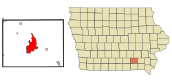
Coordinates: 41°0′47″N 92°24′53″W / 41.01306°N 92.41472°WCoordinates: 41°0′47″N 92°24′53″W / 41.01306°N 92.41472°W Country  United States
State  Iowa
IowaCounty Wapello Government – Mayor Dale Uehling Area – Total 16.5 sq mi (42.7 km2) – Land 15.8 sq mi (40.9 km2) – Water 0.7 sq mi (1.7 km2) Elevation 673 ft (205 m) Population (2010) – Total 25,036 – Rank 21st in Iowa – Density 1,516.2/sq mi (585.4/km2) Time zone CST (UTC-6) – Summer (DST) CDT (UTC-5) ZIP code 52501 Area code(s) 641 FIPS code 19-60465 GNIS feature ID 0459952 Website http://www.cityofottumwa.org/ Ottumwa (
 /əˈtʌmwə/ ə-tum-wə) is a city in and the county seat of Wapello County, Iowa, United States.[1] The population was 24,998 at the 2000 census. It is located in the southeastern part of Iowa, and the city is split into northern and southern halves by the Des Moines River.
Contents
History
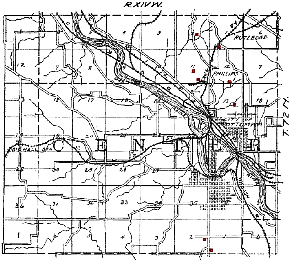
 Map of Ottumwa from 1908, showing the railroads and coal mines (shown in red) of the region.
The young town was severely damaged during the Flood of 1851.[2]
In 1857, coal was being mined from the McCready bank, a site along Bear Creek four miles west of Ottumwa. In 1868, Brown and Godfrey opened a drift mine four miles northwest of town. By 1872, Brown and Godfrey employed 300 men and had an annual production of 77,000 tons. In 1880, the Phillips Coal and Mining Company opened a mine two miles northwest of town. In subsequent years, they opened 5 more shafts in the Phillips and Rutledge neighborhoods, just north of Ottumwa.[3] The Phillips number 5 shaft was 140 feet deep, with a 375 horse power steam hoist.[4] By 1889, the state mine inspector’s report listed 15 mine shafts in Ottumwa.[5] In 1914, the Phillips Fuel Company produced over 100,000 tons of coal, ranking among the top 24 coal producers in the state.[6]
Coal mining was so important to the local economy that, from 1890 to 1892, the Coal Palace was erected in Ottumwa as an exhibition center.
Presidential Visits
Due to the Iowa Caucuses Ottumwa is no stranger to visits by presidential hopefuls. On five occasions a sitting U.S. President has visited the Bridge City:[7]
- Benjamin Harrison was the first, in 1890, touring the Coal Palace then speaking to a crowd of over forty thousand people.[7]
- In 1903 President Theodore Roosevelt made a brief stop while on a train trip around America.[7]
- President Harry Truman spent part of his 66th birthday, May 8, 1950, in Ottumwa while on a 16-state train trip in support of his Fair Deal program.[7]
- In July 1971, President Richard Nixon arrived in Air Force One at the Ottumwa Industrial Airport on his way to dedicate the nearby Rathbun Lake dam and reservoir.[8] It was a homecoming for Nixon of sorts, as he had been stationed at the Ottumwa airport while serving in the US Navy during World War Two.[9]
- On April 27, 2010 President Barack Obama spoke to a large crowd at the Hellyer Student Center on the campus of Indian Hills Community College. After the speech the president held an open forum question & answer session in a ‘town hall’ type format.[10]
Geography
Ottumwa's longitude and latitude coordinates in decimal form are 41.012917, -92.414817. [11]
According to the United States Census Bureau, the city has a total area of 16.5 square miles (43 km2), of which 15.8 square miles (41 km2) are land and 0.7 square miles (1.8 km2) (4.07%) is water.
Northeastern Wapello County contains large deposits of coal, and there are also large deposits of clay in the region, which played an important role in the industrial development of Ottumwa.[12]
Demographics
Historical populations Census Pop. %± 1860 1,632 — 1870 5,214 219.5% 1880 9,004 72.7% 1890 14,001 55.5% 1900 18,197 30.0% 1910 22,012 21.0% 1920 23,003 4.5% 1930 28,075 22.0% 1940 31,570 12.4% 1950 33,631 6.5% 1960 33,871 0.7% 1970 29,610 −12.6% 1980 27,381 −7.5% 1990 24,488 −10.6% 2000 24,998 2.1%  Wapello County Courthouse
As of the census[13] of 2000, there were 24,998 people, 10,383 households, and 6,530 families residing in the city. The population density was 1,582.2 people per square mile (610.9/km²). There were 11,038 housing units at an average density of 698.6 per square mile (269.7/km²). The racial makeup of the city was 95.33% White, 1.27% African American, 0.33% Native American, 0.78% Asian, 0.02% Pacific Islander, 1.38% from other races, and 0.89% from two or more races. Hispanic or Latino of any race were 2.76% of the population.
There were 10,383 households out of which 28.1% had children under the age of 18 living with them, 47.8% were married couples living together, 11.3% had a female householder with no husband present, and 37.1% were non-families. 31.1% of all households were made up of individuals and 14.8% had someone living alone who was 65 years of age or older. The average household size was 2.31 and the average family size was 2.88.
In the city the population was spread out with 22.9% under the age of 18, 10.9% from 18 to 24, 26.1% from 25 to 44, 21.2% from 45 to 64, and 19.0% who were 65 years of age or older. The median age was 38 years. For every 100 females there were 92.8 males. For every 100 females age 18 and over, there were 88.6 males.
The median income for a household in the city was $30,174, and the median income for a family was $37,302. Males had a median income of $31,222 versus $20,934 for females. The per capita income for the city was $16,040. About 10.9% of families and 15.2% of the population were below the poverty line, including 21.3% of those under age 18 and 8.2% of those age 65 or over.
Arts and culture
Video Game Capital of the World
As the home of Twin Galaxies, Ottumwa was proclaimed the "Video Game Capital of the World" by a mayoral decree issued on November 30, 1982 by Ottumwa Mayor Jerry Parker.[14] The city's proclamation was recognized by U.S. Senator Charles Grassley.[15] In connection with this proclamation, the city hosted the first North American Video Olympics in the fall of 1982.[16]
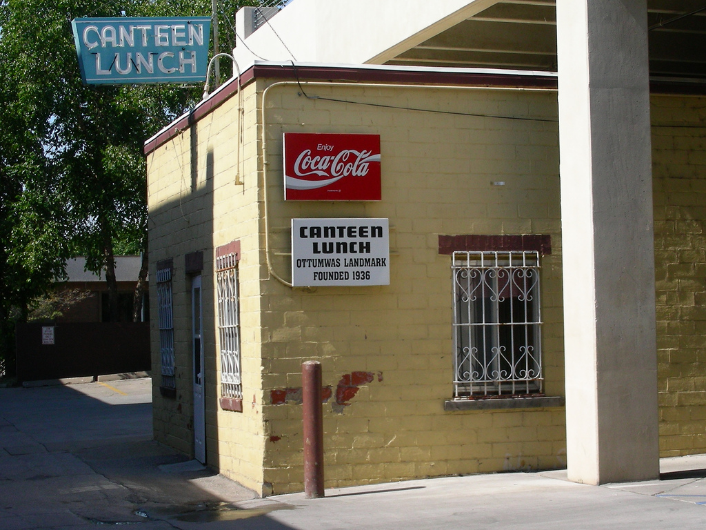
Canteen Lunch in the Alley

View of Canteen Lunch in the Alley In central downtown the Canteen Lunch in the Alley has been a stopping point for Ottumwans since the 1920s. Many famous patrons have been seen eating a "Canteen", a loose meat sandwich similar to a Maid-Rite. In the sitcom Roseanne, Roseanne Connor’s restaurant, the Lanford Lunch Box, was based on the Canteen Lunch in the Alley.[17]
Ottumwa in fiction and pop culture
- Walter Eugene "Radar" O'Reilly - Corporal from M*A*S*H television series and books was from Ottumwa, Iowa. The town was mentioned in the show on several episodes.
- The movie The Tuskegee Airmen featured the character Hannibal "Iowa" Lee Jr. (played by Laurence Fishburne), who claimed Ottumwa as his hometown.
- The television movie The Woman Who Loved Elvis, starring Rosanne Barr (then the wife of Ottumwa native Tom Arnold) was partially filmed in Ottumwa.
Education
Ottumwa High School is part of the Ottumwa public school system.
- Higher education
Ottumwa is the home of Indian Hills Community College, a two year community college. Between 1928 and 1980, it was also home to Ottumwa Heights College, a women's college that merged with Indian Hills in 1979 to create one institution. Indian Hills is located at the former Ottumwa Heights campus.
Media
Radio stations
- AM
- KBIZ-AM 1240
- KLEE-AM 1480
- FM
Television stations
- KTVO 3.1 Local ABC affiliate
- KYOU-TV 15 Local FOX affiliate (also on translator channel 25, K25DE)
- KUMK-LP 42 Local NBC affiliate (now a TBN affiliate)
- KTVO-DT2 3.2 Local CBS affiliate
- K18GU 18 Translator of KIIN Iowa City, a PBS and IPTV affiliate
- K23CI 23 Translator of KCCI Des Moines, a CBS affiliate
- K27CV 27 Translator of WHO-TV Des Moines, an NBC affiliate
Print
- Ottumwa Courier, the primary daily newspaper
Infrastructure
Transportation
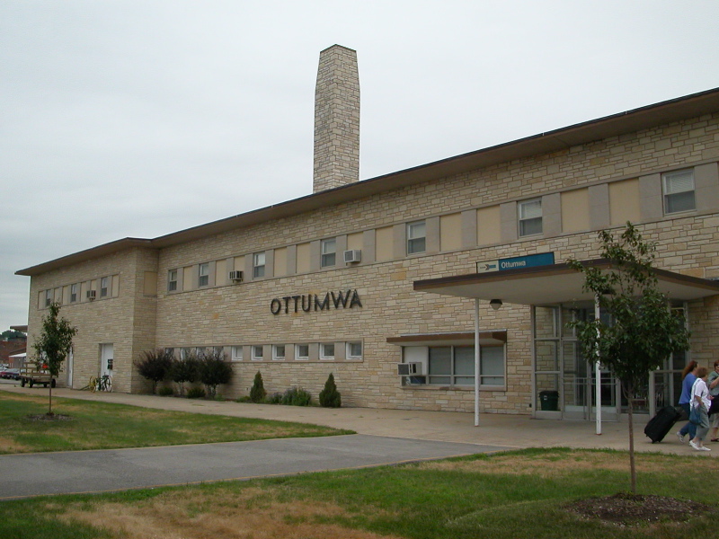
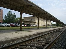 View of Amtrak passenger rail station and platform.
 Detail view of Amtrak passenger rail station.
Amtrak, the national passenger rail system, provides service to Ottumwa, operating its California Zephyr daily in both directions between Chicago, Illinois, and Emeryville, California, across the San Francisco Bay from San Francisco.
Ottumwa Transit Authority operates bus transit services throughout Ottumwa area.[18] The fixed-route system includes four routes and a shopping shuttle.[19] It also operates a para-transit service known as Ottumwa Transit Authority Lift[20] andJob Access Reverse Commute (JARC), a dial-a-ride service geared towards employees.[21]
10-15 Regional Transit Agency provides a regional dial-a-ride service throughout Appanoose, Davis, Jefferson, Keokuk, Lee, Lucas, Mahaska, Monroe, Van Buren, Wapello and Wayne counties.[22][23]
Currently, U.S. Route 34 and Iowa Highway 149 serve the town, replacing a former segment of U.S. Highway 63. Route 63 now bypasses the town as part of the Burlington to Des Moines expressway.
Railroads
The BNSF Railway has tracks through Ottumwa. This is a major corridor in the Chicago-Omaha line that is double track, and western coal makes up a large percentage of the freight carried on this line. The BNSF tracks travel under U.S. Highway 34, pass through the business district, under the U.S. Highway 63 bridge, cross the Iowa, Chicago and Eastern Railroad tracks at grade, exit Ottumwa, and later cross over the Des Moines River on their way to Albia, Iowa, and later Omaha, Nebraska.
The Iowa, Chicago & Eastern Railway was acquired by the Canadian Pacific in 2008. Ottumwa is located on the Davenport, Iowa, to Kansas City, Mo. line and is a crew change point.
The Norfolk Southern Railway has trackage rights over the BNSF through Ottumwa.
Notable people
- Tom Arnold - actor
- Chris Ash - Defensive Backs Coach of the Wisconsin Badgers football team
- Steve Bales - Apollo 11 flight controller
- Stephen Blumberg - notorious rare book thief
- Walter Day - video game statistician
- Edna Ferber - Novelist who lived in Ottumwa as a child.[24]
- Anne Marie Howard - actress
- Donald Keyhoe - Marine Corps major and aviator, UFO researcher and author
- Dan Knight - Jazz pianist, Steinway Artist, Composer. Pulitzer Prize nominee.
- Herschel Loveless (1911–1989) 34th Governor of Iowa 1957-61, Mayor of Ottumwa 1949-53 [25]
- Russell Means - American Indian activist. Attended junior college in Ottumwa
- Karen Morley - actress
- Carol Morris (born 1939) Miss Universe in 1956, actress [26]
- Harry Ostdiek - Major League Baseball player
- Beverley Owen - actress
- Jake Weimer (1873–1928) Major League Baseball player 1903-05 [27]
References
- ^ "Find a County". National Association of Counties. http://www.naco.org/Counties/Pages/FindACounty.aspx. Retrieved 2011-06-07.
- ^ Aldrich, Charles (1903). The Annals Of Iowa. Des Moines, Iowa: Historical Department of Iowa. p. 411. http://books.google.com/books?id=mrcTAAAAYAA.
- ^ Lees, James H. (1909). History of Coal Mining in Iowa. Des Moines, Iowa: Iowa Geological Survey. p. 541. http://books.google.com/books?id=1BUMAAAAYAAJ.
- ^ Hinds, Henry (1909). The Coal Deposits of Iowa. Des Moines, Iowa: Iowa Geological Survey. p. 298. http://books.google.com/books?id=1BUMAAAAYAAJ.
- ^ Fourth Biennial Report Of The State Mine Inspectors To The Governor Of The State Of Iowa For The Years 1888 And 1889. Des Moines, Iowa. 1889. p. 33. http://books.google.com/books?id=PRAAAAAAMAAJ.
- ^ Saward, Frederick E. (1915). The Coal Trade. pp. 65. http://books.google.com/books?id=NO8oAAAAYAAJ.
- ^ a b c d Toopes, Cindy (2010-04-23). "Four sitting presidents have visited Ottumwa". Ottumwa Courier. http://ottumwacourier.com/local/x1687721558/Four-sitting-presidents-have-visited-Ottumwa. Retrieved 2010-12-19.
- ^ "Rathbun Lake". US Army Corps of Engineers, Kansas City District. http://www.nwk.usace.army.mil/ra/History.cfm. Retrieved December 18, 2010.
- ^ "Biography of Richard Milhous Nixon". Richard Nixon Presidential Library and Museum. pp. 1. http://nixon.archives.gov/thelife/nixonbio.pdf. Retrieved 2010-12-19.
- ^ Shaver, Pat (2010-04-28). "Participants, crowd relish Obama visit". Ottumwa Courier. http://ottumwacourier.com/local/x1901489014/Participants-crowd-relish-Obama-visit. Retrieved 2010-12-19.
- ^ "US Gazetteer files: 2010, 2000, and 1990". United States Census Bureau. 2011-02-12. http://www.census.gov/geo/www/gazetteer/gazette.html. Retrieved 2011-04-23.
- ^ A Brief History of Wapello County, Iowa by Tom Quinn, n.d.
- ^ "American FactFinder". United States Census Bureau. http://factfinder.census.gov. Retrieved 2008-01-31.
- ^ Kalning, Kristin. "Ottumwa, video game capital of the world? - On the Level- msnbc.com". www.msnbc.msn.com. http://www.msnbc.msn.com/id/30588831/. Retrieved 2010-06-14.
- ^ "Congratulations on becoming "Video Game Capital"". www.twingalaxies.com. http://www.twingalaxies.com/index.aspx?c=18&id=1384. Retrieved 2010-06-14.
- ^ "1982 North American Video Game Olympics program cover (GIF Image, 370x574 pixels)". www.twingalaxies.com. http://www.twingalaxies.com/images/generalinfo/navgo.gif. Retrieved 2010-06-14.
- ^ "TV Acres". Restaurants, Bars & Nightclubs. http://www.tvacres.com/restaurants_lanford.htm. Retrieved 2010-12-23.
- ^ http://www.iatransit.com/services/agency_profile.asp?intAgencyID=582
- ^ http://www.ottumwatransit.com/schedule.htm
- ^ http://www.ottumwatransit.com/OTA%20Lift.htm
- ^ http://www.ottumwatransit.com/JARC.htm
- ^ http://www.iatransit.com/services/agency_profile.asp?intAgencyID=150
- ^ http://www.ottumwatransit.com/10-15.htm
- ^ Shuman, Baird (2002). Great American Writers: Twentieth Century. Marshall Cavendish. ISBN 2001028461. http://books.google.com/books?id=YBIvc_e_YwwC&pg=PA503&lpg=PA503&dq=%22Edna+Ferber%22+stomach+cancer&ct=result#v=onepage&q=ottumwa&f=false. Retrieved 2010-12-23.
- ^ "Political Graveyard". LOVELESS. http://politicalgraveyard.com/bio/lovejoy-lowdermilk.html#LOVELESS. Retrieved 2010-12-19.
- ^ "Famous Iowans - Morris, Carol". The Des Moines Register. http://www.desmoinesregister.com/article/99999999/FAMOUSIOWANS/399990424/Morris-Carol. Retrieved 2010-12-23.
- ^ "BASEBALL-Reference". Jake Weimer. http://www.baseball-reference.com/players/w/weimeja01.shtml. Retrieved 2010-12-19.
External links
- Ottumwa portal style website City government, Health, Transit, Airport and more
- Ottumwa, Iowa at the Open Directory Project
 "Ottumwa". Encyclopædia Britannica (11th ed.). 1911.
- "Ottumwa". Encyclopaedia Britannica. 18 (9th ed.). 1885.
- The Lost City of Ottumwa photo gallery on Picasa Web Albums
- Ottumwa Courier Local newspaper online
- City Data Comprehensive Statistical Data and more about Ottumwa
Municipalities and communities of Wapello County, Iowa County seat: OttumwaCities Agency | Blakesburg | Chillicothe | Eddyville‡ | Eldon | Kirkville | Ottumwa

Unincorporated
communitiesBladensburg | Dudley | Farson
Footnotes ‡This populated place also has portions in an adjacent county or counties
Categories:- Cities in Iowa
- County seats in Iowa
- Micropolitan areas of Iowa
- Ottumwa, Iowa
- Populated places established in 1843
- Populated places in Wapello County, Iowa


Wikimedia Foundation. 2010.