- Nostorf
-
Nostorf 
 NostorfLocation of Nostorf within Ludwigslust-Parchim district
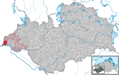
Coordinates 53°25′N 10°39′E / 53.41667°N 10.65°ECoordinates: 53°25′N 10°39′E / 53.41667°N 10.65°E Administration Country Germany State Mecklenburg-Vorpommern District Ludwigslust-Parchim Municipal assoc. Boizenburg-Land Local subdivisions 4 Mayor Joachim Kletzin Basic statistics Area 19.97 km2 (7.71 sq mi) Elevation 11 m (36 ft) Population 730 (31 December 2010)[1] - Density 37 /km2 (95 /sq mi) Other information Time zone CET/CEST (UTC+1/+2) Licence plate LWL Postal code 19258 Area code 038847 Website www.amtboizenburgland.de Nostorf is a municipality in the Ludwigslust-Parchim district, in Mecklenburg-Vorpommern, Germany.
History
Between 1945 and 1982 Nostorf's component village of Horst served as East German inner German border crossing for cars travelling along F 5 between the Soviet Zone of occupation in Germany (till 1949, thereafter the East German Democratic Republic), or West Berlin and the British zone of occupation (till 1949) and thereafter the West German Federal Republic of Germany. The traffic was subject to the Interzonal traffic regulations, that between West Germany and West Berlin followed the special regulations of the Transit Agreement (1972). In 1982 the border crossing was closed in favour of a new crossing following the route of today's Bundesautobahn 24 in Zarrentin.
References
- ^ "Bevölkerungsentwicklung der Kreise und Gemeinden" (in German). Statistisches Amt Mecklenburg-Vorpommern. 31 December 2010. http://service.mvnet.de/statmv/daten_stam_berichte/e-bibointerth01/bevoelkerung--haushalte--familien--flaeche/a-i__/a123__/2010/daten/a123-2010-22.pdf.
Categories:- Municipalities in Mecklenburg-Vorpommern
- Ludwigslust-Parchim geography stubs


Wikimedia Foundation. 2010.