- Aouderas
Infobox Settlement
official_name = PAGENAME
other_name =
imagesize =
image_caption =
image_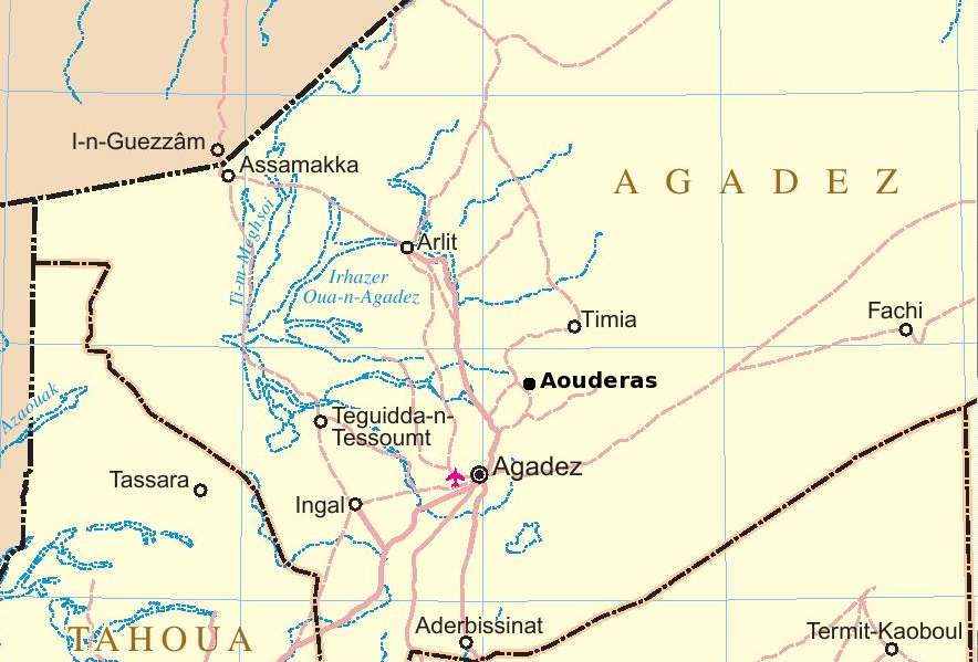
map_caption =
pushpin_
pushpin_label_position =bottom
pushpin_mapsize = 300
pushpin_map_caption =Location in Niger
subdivision_type = Country
subdivision_name =
subdivision_type1 = Department
subdivision_name1 =Agadez Department
subdivision_type2 = District
subdivision_name2 =Tchirozerine
established_title =
established_date =
government_type =
leader_title =
leader_name =
area_magnitude =
area_total_sq_mi =
area_total_km2 =
area_land_sq_mi =
area_land_km2 =
area_urban_sq_mi =
area_urban_km2 =
area_metro_km2 =
area_metro_sq_mi =
population_as_of=
population_footnotes =
population_total =
population_urban =
population_metro =
population_density_sq_mi =
population_density_km2 =
timezone =
utc_offset =
timezone_DST =
utc_offset_DST =
latd=17|latm=37|lats=|latNS=N
longd=8|longm=25|longs=|longEW=E
elevation_footnotes=
elevation_m =
elevation_ft =
postal_code_type =
postal_code =
area_code =
website =
footnotes =Aouderas (alt: "Adharous", "Auderas") is an
oasis village in theAïr Mountains of northeasternNiger , about 90km North-Northeast of the provincial capital ofAgadez . It is also the name of the valley in which the town is located.Geography
Aouderas village is in the top of the Aouderas valley, at the base of 4619 foot (1408 meter)
Mount Todra and is just south of the Todgha Mountains, which include the 6634 foot (2022 meter)Mount Bagzane (the highest point in Niger), and the Assada plateau further north. [ [http://www.indexmundi.com/zm/ng/100.htm Index Mundi/US National Imagery and Mapping Agency] and [http://www.peakbagger.com/peak.aspx?pid=11062 Peakbagger, Mont Bagzane, Niger] .] Aouderas valley is locally called aKouri , a Housa term for a seasonal wash. The washed soil sprouts grasses in the brief rainy season, some small "Dun palms" (Hyphaene thebaica ),Acacia andCalotropis procera , while the sandy bottom land to the west of the town can be thick with palms and is suitable for irrigated agriculture. Outside of this, the land is almost completely barren except for seasonal grasses.Population and History
A
Tuareg community, the small sedentary population is today made up of several hundred mostlyIkelan (or "Bouzou" in Hausa / "Bella" inSonghai ), former slaves and captives of theKel Owey Tuareg fromHausa and other southern peoples. These peoples were settled in Aouderas, as in other northern oasies, to tend thedate palm plantations fed by the oasis held by the noble clans. Situated on a plateau surrounded by mountains, Aouderas exapnded in the 19th an 20th centuries. In the 1970s, French geographers estimated there were 15000 date palms in Aouderas, more than the other older date plantations inIn Gall , but half the number of the newer plantations atTelwa andTimia to the north. [BERNUS, 1972. p.38] As of 1972, the number of farms expanded sinceHeinrich Barth 's visit in 1850, and the number of hectares under cultivation has expanded from 19.5 in 1946 to 59.3. [Mortimore (1972), pp. 81, 83, 85, 89. ] As the area of cultivation expanded, so too has the diversity, as Aouderas's existence as a servile date plantation for Tuareg caravans has declined.While the early history of the Air Massif is speculative, the area has been populated since at least 10,000 years ago, when the surrounding deserts were lush grasslands. When the Tuareg tribes were pushed south by Arab invaders in the eighth and ninth centuries CE, there were Gobirwa Hausa in the southern Air. Successive Tuareg "Tel"s have controlled the area since at least the twelfth century. Agadez, as well as Ingall to the east, were the farthest outposts of the
Songhai Empire in the early 1th century. In the Sixteenth century the area fell under the newly created TuaregSultanate of Air , and remained so until the arrival of the French at the end of the 19th. Barth passed through the Aouderas valley in 1850, and reported that it was only recently that the Kel Owey [Bernus (1972) says that, specifically, it was the Kel Negru sub-clan of the Kel Owey.] had pushed theKel Geres andKel Itesen Tuareg south and west out of the valley. Some Itesen landowners, though, remained Aouderas as late as 1970. While the Kel Owey pastoralised in the region, visiting towns and their plantations irregularly, Aouderas developed a small but unusual sedentary population of Tuareg cultivators. Barth also described this valley as the southernmost instance ofplow agriculture, though he witnessed the local servile population pulling the plows in place of farm animals. Despite dire social conditions for the sedentary population and frequent raids from rival Tels andToubu pastoralists, the sendentary Ikelan had built a large fertile island in the Air.From one of the largest oases in the area, Aouderas was abandoned in 1917-18. A violent 1875 flood destroyed most of the date plantation, and the emergence of the French weakened Kel Owey defences. From the 1880s, Toubu raids increased, and when the Tuareg
Kaosen Ag Mohammed rose against the French in 1917, Aouderas was one of the towns he destroyed on his way to the siege of Agadez. When the French retook Agadez, a brutalpunitive expedition through the Air left Aouderas abandoned.By 1924, though, Aouderas was resettled, both with the remains of the local Ikelan, but also with refugees from
Iferwan , also razed by Kaosen and the French successively. At this time it was the second largest town in the Air, after Agadez. [Jolijn Geels. Niger. Bradt London and Globe Pequot New York (2006). ISBN 1841621528] While the Kel Owey continued to dominate the town, the sedentary farmers now held and inherited much of the Aouderas gardens, rare in the region. [Mortimore (1972) points out that while Tibia farmers held their own land, they were descendants of Tuareg freemen, not slaves] Most non-resident Tuareg land owners in 1946 were women, holding land under what the Tuaregs call a "khabus",matralineal , system. As the gardens prospered, more towns were formed to the west by Aouderas residents, the largest beingTegmak .The famines of the 1970s and 80s brought an end to this expansion, and as
Agadez andArlit grew, Aouderas shrunk. TheTuareg Rebellion of the 1990s saw brutal government reprisals which depopulated many villages in the Air. Finally, in 2004, a locust invasion ravaged the Aouderas gardens. [Geels (2006)]Tourist industry
Today, with caravan trade dwindled, date crops are suplemented with market gardens, citrus, and increasingly the tourist trade centered in Agadez. A rough "piste" (dirt road) links the town with Agadez, and the larger Tuareg settlement (and tourist destination) in the north of the Air,
Iferouane , and is on the main route from Agadez toTimia , a larger oasis in the north. Other nearby oasis towns include the more visitedElmeki , 20 km to the west,Tammazaret , 40km to the north, andDabbaga on the road to Agadez to the south. [ see:
fr [http://www.vtt.org/article.php?id_article=44 VTT.org, Randonnée dans le Sahara du Niger] . Travel itinerary through the Air via Aouderas, including photos] .
fr [http://www.agadez-niger.com/page-oasis-timia.html Agadez to Timia itinerary with photos and maps.] ]Tuareg Rebellion, 2007
On 7 September, 2007, a small Nigerien military garrison at Aouderas was attacked by Tuareg led MNJ rebels, taking six soldiers captive. The 2007 Tuareg insurgency has essentially precluded any 2007 tourist season, while roads have been mined, and locals fear attacks by both the rebels and the army. The entire area saw brutal army reprisals in the early 1990s during the last Tuareg insurgence which ended in 1995. [ [http://www.alertnet.org/thenews/newsdesk/L07517688.htm Niger rebels kidnap six soldiers in desert raid. Reuters: 07 Sep 2007] . [http://news.bbc.co.uk/2/hi/africa/6983929.stm Tuareg rebels seize Niger troops. BBC: 7 September 2007] .]
References
*Frederick Brusberg. Production and Exchange in the Saharan Air, in Current Anthropology, Vol. 26, No. 3. (Jun., 1985), pp. 394-395. "Field research on the econmoics of the Aouderas valley, 1984."
*Michael J. Mortimore. The Changing Resources of Sedentary Communities in Air, Southern Sahara, in Geographical Review, Vol. 62, No. 1. (Jan., 1972), pp. 71-91.
* [http://horizon.documentation.ird.fr/exl-doc/pleins_textes/pleins_textes_5/b_fdi_04-05/05798.pdf Edouard Bernus. "Les palmeraies de l'Aïr", Revue de l'Occident Musulman et de la Méditerranée, 11, (1972) pp.37-50] .
* [http://www.fallingrain.com/world/NG/1/Aouderas.html fallingrain.com: Geographical data for Aouderas] .Not Consulted
*Frederick Brusberg. Economy and society of Aouderas, a community of the Saharan Air Massif (Niger), Doctoral thesis, Dept. of Anthropology, McGill University (1988)
External links
* [http://www.flickr.com/photos/beat/65174286/ Tourist photo of Aouderas, October, 2005] .
* [http://www.moonglow.net/eclipse/2006mar29/index.shtml March 2006, pictures from tourist trek, passing through Aouderas.]
* [http://www.fotocommunity.com/pc/pc/cat/231/display/7949837 Children at play in an Aouderas street scene]
* [http://www.agadez-niger.com/photo-142-7.html Traditional dancers from Aouderas] perform at the "festival de l'Aïr" in Iferouane, December, 2005.
* [http://bp.crwrc.org/?action=d7_article_display&Class=Article&ID=1465&Join_ID=19493 Detailed report on literacy training classes in Aouderas] from theChristian Reformed World Relief Committee .

Wikimedia Foundation. 2010.