- Osawatomie, Kansas
-
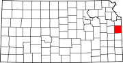
Osawatomie, Kansas — City — Statue of John Brown in Osawatomie Location of Osawatomie, Kansas
Coordinates: 38°30′6″N 94°57′3″W / 38.50167°N 94.95083°WCoordinates: 38°30′6″N 94°57′3″W / 38.50167°N 94.95083°W Country United States State Kansas County Miami Platted Incorporated 1890 Government - Type Mayor–Council - Mayor Phil Dudley[1] - City Clerk Ann Elmquist[1] Area - Total 4.5 sq mi (11.6 km2) - Land 4.4 sq mi (11.5 km2) - Water 0.0 sq mi (0.1 km2) Elevation 869 ft (265 m) Population (2010)[2] - Total 4,447 - Density 988.2/sq mi (381.6/km2) Time zone Central (CST) (UTC-6) - Summer (DST) CDT (UTC-5) ZIP code 66064 Area code(s) 913 FIPS code 20-53225[3] GNIS feature ID 0479709[4] Osawatomie is a city in Miami County, Kansas, United States, 61 miles (98 km) southwest of Kansas City. As of the 2010 census, the city population was 4,447.[2] It derives its name from two streams nearby, the Osage and Potawatomie.
Contents
History
Osawatomie's name is a compound of two primary native American Indian tribes from the area, the Osage and Pottawatomie. In addition, the town is bordered by Pottawatomie Creek and the Marais des Cygnes River (part of the Osage River system), which are also named for the two tribes.[5]
The Emigrant Aid Society's transport of settlers to the Kansas Territory as a base for Free State forces played a key role in the establishment of the community of Osawatomie in October 1854. Settled by abolitionists in hopes of aiding Kansas' entry to the United States as a free state, the community of Osawatomie and pro slavery communities nearby were quickly engaged in violence.[6]
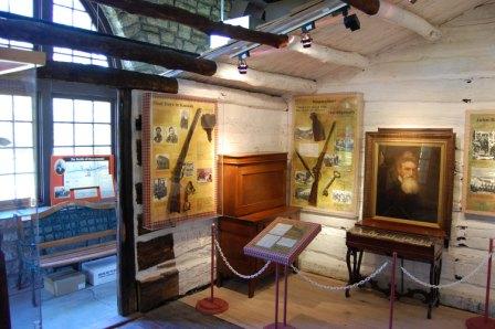
 John Brown Museum
In March 1855, abolitionists Rev. Samuel Adair and his wife Florella settled in a cabin near Osawatomie to serve as missionaries to the community. Florella's half-brother, John Brown came to "Bleeding Kansas" later the same year with a wagon of guns in order to help fight the pro slavery forces like his five sons, who were already living in another community in the area. Brown then came to Osawatomie to visit the Adair's and fight pro slavery forces there. By 1856, having established himself as a leader of free state guerillas, Brown made Osawatomie and the Adair cabin his base. In a raid in May 1856, Brown killed five pro slavery men along Pottawatomie Creek near Osawatomie. This was then referred to as the "Pottawatomie Massacre", which inflamed the fighting throughout the Kansas Territory.[7] The second and main Battle of Osawatomie took place on August 30, 1856. Osawatomie played a key role throughout the Civil War, serving as a center for Jayhawker activity.[8]
By 1857 Osawatomie had grown to a town of 800 and in 1859 hosted the first convention of the Kansas Republican Party.[8] In recognition for Osawatomie's part in ensuring Kansas remained a free state, the Kansas Legislature established the Osawatomie State Mental Hospital in 1863, the first mental hospital west of the Mississippi River. It admitted its first patient in 1866, and is still operational.[6] By 1879, a railroad was built to serve Osawatomie, aiding its growth into a supply town and a main shipping point. As a result, Osawatomie grew to a population of 4,046 by 1910.[8] Osawatomie was a division point for the Missouri Pacific Railroad and the Union Pacific Railroad from 1879 to 1985.[7]
Osawatomie was chartered in 1883 and in 1890 became a second-class city. The commission form of government was adopted in 1914.[citation needed]
Battle of Osawatomie
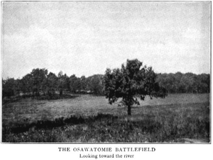
The first skirmish in Osawatomie took place on June 7, 1856 however there was not much of a fight, and no blood was shed. The town's buildings were plundered, and some horses were taken.[8] The larger, and main conflict known as the Battle of Osawatomie began August 30, 1856 as John Brown was camped just north Osawatomie and looking east for pro-slavery forces. A pro-slavery force of 250, led by John William Reid, came riding into Osawatomie from another direction. One of John Brown's sons Frederick Brown was walking to the Adair cabin at the time, and was shot. When Reverend Adair heard the shot, he sent his own son to warn and notify John Brown of the raid.[6] Brown and 31 of the free state guerillas took positions to attempt to defend Osawatomie. Heavy gunfire took place for over 45 minutes,until Brown and his men ran out of ammunition. They retreated hoping they would be chased, and the community of Osawatomie would be left alone. However, despite the attempts of John Reid to get his men to follow, they instead looted and burned Osawatomie. Only three buildings remained standing when it was over.[7]
Theodore Roosevelt visit and speech
On August 31, 1910, Theodore Roosevelt gave his famous New Nationalism speech in Osawatomie. The central issue he argued was government protection of human welfare and property rights.[9]
Geography
Osawatomie is located at 38°30′6″N 94°57′3″W / 38.50167°N 94.95083°W (38.501650, -94.950799)[10], along the Marais des Cygnes River. According to the United States Census Bureau, the city has a total area of 4.5 square miles (12 km2), of which, 4.4 square miles (11 km2) of it is land and 0.1 square miles (0.26 km2) of it (1.11%) is water.
Demographics
Historical populations Census Pop. %± 1990 4,590 — 2000 4,645 1.2% 2010 4,447 −4.3% U.S. Decennial Census As of the census[3] of 2000, there were 4,645 people, 1,781 households, and 1,130 families residing in the city. The population density was 1,045.0 people per square mile (403.9/km²). There were 1,947 housing units at an average density of 438.0 per square mile (169.3/km²). The racial makeup of the city was 92.21% White, 4.16% African American, 0.47% Native American, 0.22% Asian, 0.04% Pacific Islander, 0.75% from other races, and 2.15% from two or more races. Hispanic or Latino of any race were 2.54% of the population.
There were 1,781 households out of which 34.7% had children under the age of 18 living with them, 44.9% were married couples living together, 13.3% had a female householder with no husband present, and 36.5% were non-families. 31.6% of all households were made up of individuals and 14.1% had someone living alone who was 65 years of age or older. The average household size was 2.42 and the average family size was 3.03.
In the city the population was spread out with 27.2% under the age of 18, 9.9% from 18 to 24, 30.0% from 25 to 44, 18.6% from 45 to 64, and 14.3% who were 65 years of age or older. The median age was 34 years. For every 100 females there were 90.6 males. For every 100 females age 18 and over, there were 91.9 males.
The median income for a household in the city was $29,104, and the median income for a family was $37,172. Males had a median income of $30,650 versus $23,043 for females. The per capita income for the city was $15,353. About 10.9% of families and 12.9% of the population were below the poverty line, including 16.5% of those under age 18 and 10.6% of those age 65 or over.
Historical Places
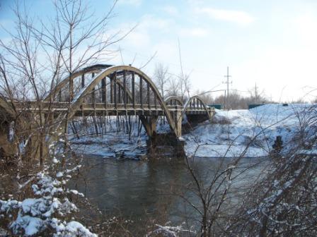
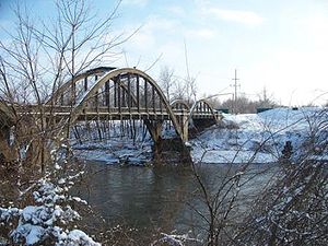 Creamery Bridge: One of the two historic Marsh Arch triple span bridges in Osawatomie
Osawatomie has several historical places, 5 of which are listed on the National Historic Register.
- The Mills House - A 7,000 sq ft (650 m2). Queen-Anne style home built in 1902 for William Mills.
- Asylum Bridge - An unusual bridge built in 1906 connecting the community to the state mental hospital.
- Creamery Bridge - In 1930, this bridge was built crossing the Marais des Cygnes River. Another just like it crosses the Pottawatomie Creek. Osawatomie is between the two. Both bridges are on the National Historic Register.
- John Brown Museum State Historic Site: The site of the Battle of Osawatomie is contained in the John Brown Memorial Park. Also, the Adair Cabin is exhibited there.[5] According to the Scientific American of May 27, 1893, Osawatomie was struck by a meteor on April 8, 1893, striking the statue of John Brown.
Community
 Baseball at Karl Cole sports complex
The community of Osawatomie offers a museum and driving tour for learning of its history, and also offers its residents various opportunities for recreation. There is an 18-hole golf course, and the Osawatomie City Lake for fishing. The Miami County Family YMCA is also in Osawatomie, which has an indoor pool, a gymnasium, weight room, indoor track, and offers programs for all ages. The Karl Cole Sports Complex in Osawatomie is used for athletic events such as baseball, softball, soccer, and youth football.[6]
Government
The Osawatomie government consists of a mayor and eight council members. The council meets the 2nd and 4th Thursday of each month at 7PM.[1]
- City Hall, 439 Main Street.
Education
Four schools comprise the Osawatomie Unified School District #367.
- Swenson Early Childhood Education Center (Pre-K and K)
- Trojan Elementary (grades 1-5)
- Osawatomie Middle School (grades 6-8)
- Osawatomie High School (grades 9-12)
On the 2009 Kansas State Assessments, Osawatomie High School achieved building wide Standard of Excellence Awards in both reading and math. The Osawatomie Middle School achieved a building wide Standard of Excellence Award in reading.[11]
Faculty of USD #367 have received the Kansas Master Teacher of the Year three times, Kansas Teacher of the Year twice, and have also received once each the Kansas Reading Teacher of the Year, Kansas Social Studies Teacher of the Year, and Kansas Counselor of the Year.[12]
References
- ^ a b c Osawatomie - Directory of Public Officials
- ^ a b "2010 City Population and Housing Occupancy Status". U.S. Census Bureau. http://factfinder2.census.gov/faces/tableservices/jsf/pages/productview.xhtml?pid=DEC_10_PL_GCTPL2.ST13&prodType=table. Retrieved April 6, 2011.
- ^ a b "American FactFinder". United States Census Bureau. http://factfinder.census.gov. Retrieved 2008-01-31.
- ^ "US Board on Geographic Names". United States Geological Survey. 2007-10-25. http://geonames.usgs.gov. Retrieved 2008-01-31.
- ^ a b "History of Osawatomie". City of Osawatomie. http://www.osawatomieks.org/. Retrieved 2009-11-16.
- ^ a b c d "Miami County 2009 Visitors Guide", pages 8-10
- ^ a b c "Miami County 2008 Visitors Guide", pages 11-16
- ^ a b c d "Osawatomie - Cyclopedia 1912". The KSGenWeb Project. http://skyways.lib.ks.us/genweb/archives/index.html/. Retrieved 2009-11-16.
- ^ "The New Nationalism", text of Theodore Roosevelt's August 31, 1910 speech in Osawatomie, Kansas
- ^ "US Gazetteer files: 2010, 2000, and 1990". United States Census Bureau. 2011-02-12. http://www.census.gov/geo/www/gazetteer/gazette.html. Retrieved 2011-04-23.
- ^ "2009 Standard of Excellence Schools". Kansas Department of Education. http://www.ksde.org/LinkClick.aspx?fileticket=bnOkNkD7lKM%3D&tabid=36. Retrieved 2009-11-17.
- ^ "Quality of Life". Osawatomie Chamber of Commerce. http://www.osawatomiechamber.org/. Retrieved 2009-11-16.
External links
- City of Osawatomie
- Osawatomie - Directory of Public Officials
- John Brown Museum
- Historic letters written from Osawatomie
Municipalities and communities of Miami County, Kansas County seat: Paola Cities Fontana | Louisburg | Osawatomie | Paola | Spring Hill‡
Unincorporated
communitiesBucyrus | Hillsdale
Footnotes ‡This populated place also has portions in an adjacent county or counties
Categories:- Populated places in Miami County, Kansas
- Cities in Kansas


Wikimedia Foundation. 2010.