- Mangystau Province
-
Mangystau Province
Маңғыстау облысы
Мангистауская область— Province — Map of Kazakhstan, location of Mangystau Province highlighted
Coordinates: 43°52′N 052°00′E / 43.867°N 52°ECoordinates: 43°52′N 052°00′E / 43.867°N 52°E Country  Kazakhstan
Capital Aktau Government – Akim Krymbek Kusherbayev Area[1] – Total 165,600 km2 (63,938.5 sq mi) Population (2006-12-01)[2] – Total 373,400 – Density 2.3/km2 (5.8/sq mi) Time zone West (UTC+5) – Summer (DST) not observed (UTC+5) Postal codes 130000 Area codes +7 (729) ISO 3166 code KZ-MAN Vehicle registration R Districts 5 Cities 3 Townships 6 Villages 30 Website www.mangystau.kz Mangystau Province (Kazakh: Маңғыстау облысы, Mañğıstaw oblısı) is a province of Kazakhstan. Its capital is Aktau (a seaport), which has a population of 154,500 (2004 census); the entire Mangystau province has a population of 373,400.
Contents
Geography
The province is located in the southwest of the country, and includes Mangyshlak Peninsula. It has much of Kazakhstan's Caspian Shore. It also borders neighboring countries Turkmenistan and Uzbekistan. Mangystau also borders two other Kazakh provinces(counter-clockwise), Aktobe Province and Atyrau Province. The area of the province is 165,600 square kilometers. Engineers discovered petroleum in the area in the days of the Soviet Union, drilling commenced, and much of the area was built up around the industry.
The territory of Mangystau includes lots of different landscapes and desert lands: Caspian lowland, plateaus (Usturt, Mangyshlak, Kendirli-Kayasan), mountains (Aktau, Karatau), cavities, desert, mountains and mountain ridges. That kind of landscape forms an original multigraded labyrinth, painted with green, yellow, pink and red sediment of loam. The highest point is Otpan mountain at 556 metres (1,824 ft). The lowest point is the bottom of Karagie cavity, 132 metres (433 ft) below sea level.
Climate
Due to its vast territory, the province has a wide variety of climate conditions. The climate of north Mangystau is cold in winter due to its settlement in Usturt plateau, the location of the plateau is mainly above sea level. On the whole, the climate is continental with cold winters and mild summers. The average temperature −3 °C (27 °F) in January and +26 °C (79 °F) in July. The average annual rainfall is 150 millimetres (5.9 in).
History
The first written sources on Mangystau province dates back to the 1890s.
Demographics
 Mangystau Province in winter time
According to the 1999 Census, Kazakhs (50.9%) outnumbered ethnic Russians (32.9%) by a wide margin.[3]
- Population (2009): 416 500 people (2,6 %, 14 place)
- Density: 2,5 people / km ² (13 place)
- National structure: Kazakhs — 70,9 %; RussianS — 22,9 %
- Are: 165,600 in km ² (6,1 %, 7 place)
References
External links
 Media related to Mangystau Province at Wikimedia Commons
Atyrau Province Aktobe Province Caspian Sea 
Karakalpakstan,  Uzbekistan
 Mangystau Province

Balkan Province,  TurkmenistanCapital: Aktau
Districts 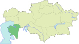
Major cities  Provinces of Kazakhstan
Provinces Akmola · Aktobe · Almaty · Atyrau · East Kazakhstan · Karagandy · Kostanay · Kyzylorda · Jambyl · Mangystau · North Kazakhstan · Pavlodar · South Kazakhstan · West Kazakhstan
Metropolitan cities Categories:- Kazakhstan geography stubs
- Mangystau Province
- Provinces of Kazakhstan


Wikimedia Foundation. 2010.