- Brownsville, Kentucky
Infobox Settlement
official_name = Brownsville, Kentucky
settlement_type =City
nickname =
motto =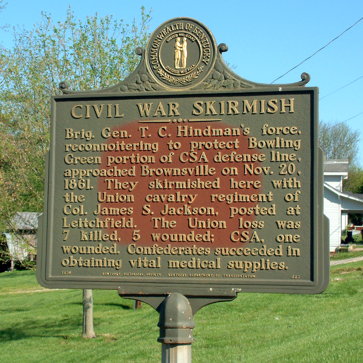
imagesize = 250px
image_caption = Historical marker in Brownsville
image_
mapsize = 250px
map_caption = Location of Brownsville, Kentucky
mapsize1 =
map_caption1 =subdivision_type = Country
subdivision_name =United States
subdivision_type1 = State
subdivision_name1 =Kentucky
subdivision_type2 = County
subdivision_name2 = Edmonson
government_footnotes =
government_type =
leader_title =
leader_name =
leader_title1 =
leader_name1 =
established_title =
established_date =unit_pref = Imperial
area_footnotes =area_magnitude =
area_total_km2 = 4.1
area_land_km2 = 4.1
area_water_km2 = 0.0
area_total_sq_mi = 1.6
area_land_sq_mi = 1.6
area_water_sq_mi = 0.0population_as_of = 2000
population_footnotes =
population_total = 921
population_density_km2 = 224.3
population_density_sq_mi = 581.0timezone = Central (CST)
utc_offset = -6
timezone_DST = CDT
utc_offset_DST = -5
elevation_footnotes =
elevation_m = 166
elevation_ft = 545
latd = 37 |latm = 11 |lats = 28 |latNS = N
longd = 86 |longm = 15 |longs = 40 |longEW = Wpostal_code_type =
ZIP code
postal_code = 42210
area_code = 270
blank_name = FIPS code
blank_info = 21-10324
blank1_name = GNIS feature ID
blank1_info = 0488045
website =
footnotes =Brownsville is a city in and the
county seat of Edmonson County,Kentucky ,United States .GR|6 The population was 921 at the 2000 census. It is included in theBowling Green, Kentucky Metropolitan Statistical Area. It is just outsideMammoth Cave National Park .Geography
Brownsville is located at coor dms|37|11|28|N|86|15|40|W|city (37.191169, -86.261098)GR|1.
According to the
United States Census Bureau , the city has a total area of 1.6square mile s (4.1km² ), of which, 1.6 square miles (4.1 km²) of it is land and 0.62% is water.Demographics
As of the
census GR|2 of 2000, there were 921 people, 387 households, and 229 families residing in the city. Thepopulation density was 581.0 people per square mile (223.6/km²). There were 421 housing units at an average density of 265.6/sq mi (102.2/km²). The racial makeup of the city was 98.37% White, 0.11% African American, 0.43% Native American, 0.11% Asian, 0.11% from other races, and 0.87% from two or more races. Hispanic or Latino of any race were 0.76% of the population.There were 387 households out of which 26.4% had children under the age of 18 living with them, 40.6% were married couples living together, 16.8% had a female householder with no husband present, and 40.6% were non-families. 37.5% of all households were made up of individuals and 15.8% had someone living alone who was 65 years of age or older. The average household size was 2.15 and the average family size was 2.81.
In the city the population was spread out with 20.3% under the age of 18, 8.6% from 18 to 24, 22.8% from 25 to 44, 24.4% from 45 to 64, and 23.9% who were 65 years of age or older. The median age was 43 years. For every 100 females there were 72.5 males. For every 100 females age 18 and over, there were 71.1 males.
The median income for a household in the city was $15,370, and the median income for a family was $21,250. Males had a median income of $26,125 versus $14,583 for females. The
per capita income for the city was $15,711. About 30.8% of families and 32.6% of the population were below thepoverty line , including 45.2% of those under age 18 and 24.5% of those age 65 or over.References
External links
* [http://geonames.usgs.gov/pls/gnispublic/f?p=gnispq:3:::NO::P3_FID:488045 Brownsville] at the U.S.
Geographic Names Information System
*geolinks-US-cityscale|37.191169|-86.261098
Wikimedia Foundation. 2010.