- Datil, New Mexico
-
Datil, New Mexico — Unincorporated area — Location within the state of New Mexico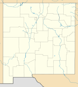 <div style="position: absolute; z-index: 2; top: Expression error: Missing operand for *%; left: 1681.5%; height: 0; width: 0; margin: 0; padding: 0;">
 Datil, New Mexico
Country United States State New Mexico County Catron Population (2000) – Total 621 Time zone Mountain (MST) (UTC-5) – Summer (DST) MDT (UTC) Area code(s) 575 GNIS feature ID Datil is an unincorporated town in Catron County, New Mexico, United States. Located at the intersection of U.S. Route 60 and New Mexico State Road 12, Datil is on the edge of the Cibola National Forest. The Very Large Array is also nearby. Rock climbers are attracted to Datil because it hold the Enchanted Tower, a climbing hotspot.
References
Municipalities and communities of Catron County, New Mexico Village 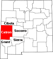
Unincorporated
communitiesAlma | Apache Creek | Cruzville | Datil | Glenwood | Luna | Old Horse Springs | Pie Town | Pleasanton | Quemado | San Francisco Plaza
Ghost towns Coordinates: 34°08′40″N 107°50′39″W / 34.14444°N 107.84417°W
Categories:- Unincorporated communities in Catron County, New Mexico
- New Mexico geography stubs


Wikimedia Foundation. 2010.