- Cityscape of Tampa
-
 Downtown Tampa from Curtis Hixon Park
Tampa is home to numerous structures that are noteworthy due to their architectural characteristics or historic associations, the most noteworthy being the Seminole Heights and Hyde Park neighborhoods, two of the largest historic preservation districts in the city.
Contents
Business districts
The downtown business district of Tampa is located immediately east of the Hillsborough River, and southwest of the Ybor City Historic District. Tampa International Airport is located approximately 4 miles (6 km) west-northwest of the downtown area, and easily connected to most parts of the city by three Interstate Highways, maximizing its accessibility. The largest industrial sections of town are located to the north of the airport and east of the city limits, while most of the residential areas of the city are located to the southwest, northwest, northeast and west of downtown.
Another major business district is the Westshore Business District, located east of Tampa Bay and south of Tampa International Airport. Currently, Westshore has more than 11,000,000 square feet (1,000,000 m2) of commercial office space, 4,000 businesses with nearly 100,000 employees, 32 hotels, 2 major shopping malls (International Plaza and Bay Street and WestShore Plaza). The city of Tampa has 165 parks with 2,286 acres (9 km2) within its borders.[1]
Architecture
 Colonial house in Hyde Park
The city's architecture contains a blend of old and new. The neighborhoods of Seminole Heights, Tampa Heights, and Hyde Park neighborhoods are historic preservation districts featuring mostly Victorian homes and buildings.
Neighborhoods and Districts
The city is divided into many neighborhoods, many of which were towns and unincorporated communities that were annexed by the growing city. Generally, the city is divided into the following areas: Downtown Tampa, New Tampa, West Tampa, East Tampa, North Tampa, and South Tampa.
East Tampa
On the eastern portion of the city lies residential neighborhoods of College Hill, Jackson Heights-Belmont Heights, Ybor City, East Ybor, Southeast Seminole Heights, Northeast Community, Northview Hills, Live Oaks Square, Rivergrove, Grant Park, South Nebraska, Woodland Terrace and the industrial section of Gary, just east of downtown. The historic section of Ybor City is also located within this district.[2]
Downtown Tampa
Besides the financial district, two upscale residential neighborhoods are Davis Island and Harbour Island.
South Tampa
On the southern portion of the city lies residential neighborhoods of Ballast Point, Fair Oaks - Manhattan Manor, Gandy-Sun Bay South (or just Sun Bay South), Golf View, Palma Ceia, South Westshore, Bayshore Beautiful, Bayshore Gardens, Belmar Shore, Port Tampa , Golfview, New Suburb Beautiful, and Virginia Park. The region also contains portions of Sunset Park and Oscawana.[3]
West Tampa
On the western portion of the city lies residential neighborhoods of Armenia Gardens Estates, Beach Park, Beach Park Isles, Bon Air, Carver City-Lincoln Gardens, Culbreath Bayou, Culbreath Isles, Drew Park, Gray Gables, Lowry Park, Mid-Peninsula, Midtown, North Bon Air, North Hyde Park, Oakford Park, Palma Ceia West, Parkview, Plaza Terrace, Ridgewood River, Riverbend, Riverside Heights, South Seminole Heights, Wellswood, West Tampa, Westshore Palms.[4]
In the West Tampa District, the sublets include Bowman Heights, MacFarlane Park, Northeast Macfarlane, Marina Club, and Old West Tampa.
The West Tampa region also contain parts of Lowry Park North, Southeast Seminole Heights, Sunset Park and Tampa Heights.
North Tampa/New Tampa
On the northern portion of the city lies residential neighborhoods of Forest Hills, Sulphur Springs, Temple Crest, Terrace Park, University Square, and North Tampa (neighborhood).
Meanwhile, with characteristics of its own, the New Tampa district contains several upscale neighborhoods. They include Hunter's Green, Hunter's Key, and Tampa Palms.
Tallest buildings
- see also: tallest buildings in downtown Tampa.
The tallest buildings in Tampa are all in downtown.[5]
Building Height (meters) Stories Year Completed 100 North Tampa (formally AmSouth Building)[6] 176 42 1992 Bank of America Tower[7] 176 42 1986 One Tampa City Center[8] 164 38 1981 SunTrust Financial Centre[9] 160 36 1992 Park Tower[10] 140 36 1973 Rivergate Tower[11] 138 32 1988 Hillsborough County Center[12] 114 28 1993 Transportation infrastructure
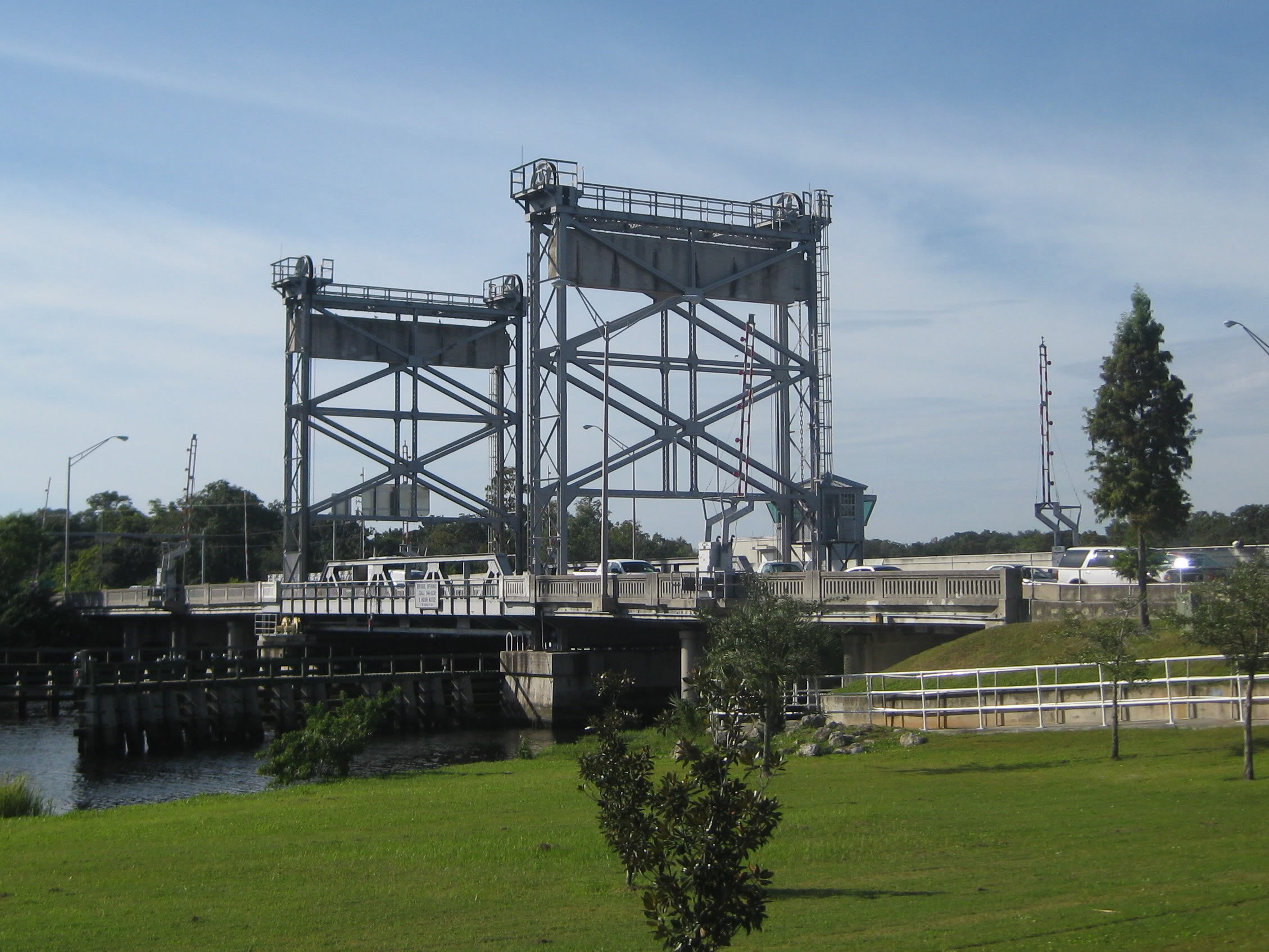
 Hillsborough Avenue Bridge
Along the city's western shore, three bridges span Old Tampa Bay carrying vehicular traffic to and from Pinellas County: the Howard Frankland Bridge (I-275), the Courtney Campbell Causeway (SR 60), and the Gandy Bridge (US 92).
Tampa is served by two major limited access toll road expressways. From its suburban eastern terminus of Brandon, the Lee Roy Selmon Expressway (SR 618) enters Tampa by way of a bridge crossing the Tampa Bypass Canal. It is a major commuter artery into downtown and continues down the South Tampa peninsula, ultimately reaching its western terminus at Gandy Boulevard (U.S. Route 92) near MacDill Air Force Base.
The Veterans Expressway (SR 589) begins at the city's western edge near the Tampa International Airport, connecting to SR 60's westbound Courtney Campbell Causeway and eastbound Memorial Highway. The Veterans Expressway leaves the city limits heading north to the suburbs of Carrollwood, Northdale, Westchase, Citrus Park, Cheval, and Lutz. Before leaving Hillsborough County, SR 589 becomes the Suncoast Parkway, which continues northward into Pasco and Hernando Counties.
Three Interstate Highways pass within the city limits. Interstate 4 originates from Tampa's Malfunction Junction, where it intersects Interstate 275. I-275 is a main artery into the city from Pinellas County, and continues into downtown and northward through neighborhoods like Seminole Heights and Sulphur Springs before leaving Tampa to reunite with Interstate 75 at the Pasco county line. Immediately south of this junction, I-75 crosses through the city neighborhood of New Tampa.
Other main arteries within the city include major surface roads like Hillsborough Avenue, Dale Mabry Highway, Bruce B. Downs Boulevard, Busch Boulevard, Nebraska Avenue, Florida Avenue, Fowler Avenue, Kennedy Boulevard, Adamo Drive, and Dr. Martin Luther King Jr. Boulevard.
Other infrastructure
 Tampa International Airport
Airports
Main article: List of airports in the Tampa Bay area Tampa International Airport (IATA: TPA, ICAO: KTPA) is Tampa's main airport and primary location for passenger commercial airline service into the Tampa Bay area. During 2008, it was the 26th-busiest airport in North America.[13] The airport is a consistent favorite in surveys of the industry and the traveling public. The readers of Condé Nast Traveler have frequently placed Tampa International in their list of Best Airports, ranking it #1 in 2003[14], and #2 in 2008[15] A survey by Zagat in 2007 ranked Tampa International first among U.S. airports in overall quality[16].
- Peter O. Knight Airport (IATA: TPF, ICAO: KTPF)is a small general aviation terminal located on Davis Islands near downtown.
- Tampa Executive Airport (IATA: VDF, ICAO: KVDF), formerly known as Vandenberg Airport, is another option for general aviation fliers. The airport is located east of Tampa in Hillsborough County, near the I-4/I-75 interchange.
- St. Petersburg-Clearwater International Airport (IATA: PIE, ICAO: KPIE) lies just across the bay from Tampa International Airport. Though mainly a general aviation facility, the airport has become an increasingly popular location for passenger service by discount and charter carriers.
 Tampa Union Station
Railroads
The railroad legacy brought to Tampa by Henry Plant continues to serve the city. Uceta Rail Yard was established by Plant System corporate descendant, Atlantic Coast Line Railroad, in the Gary industrial sector on Tampa's east side, near Brandon. It continues to service CSX as a storage and intermodal freight transport facility today. Freight and container cargo operations at the city's seaports also depend upon dockside rail facilities[17].
Tampa's intercity passenger rail service has since 1912 been based out of Tampa Union Station. The historic facility, adjacent to downtown between the Channel District and Ybor City, is serviced by Amtrak today. Amtrak's Silver Star calls on Tampa twice daily: number 91 southbound to Miami and number 92 northbound for New York City[18].
Union Station also serves as the transfer hub for Amtrak Thruway Motorcoach service, offering bus connections to several cities in Southwest Florida, as well as to Orlando for transfers to the northbound Silver Meteor[18].
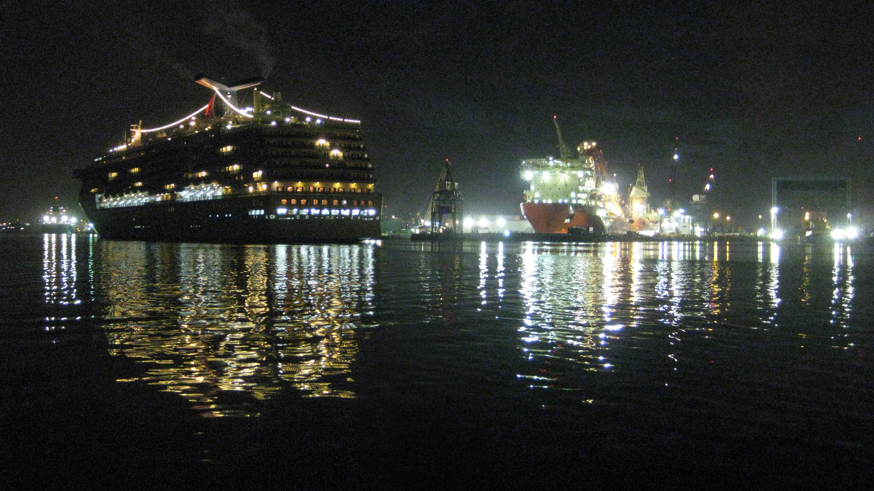
 Early morning at the Port of Tampa
Seaports
Since Tampa Bay was first spotted by Spanish explorers in the 16th century, sailors have admired its wide, sheltered beauty. But it had a problem; it's naturally very shallow - less than 30 feet (9 m) deep almost everywhere and well less than that in many places near the coast, including the approach to the small town of Tampa.[19]. By the late 19th century, typical cargo ships had grown large enough that they were not able to navigate upper Tampa Bay and reach the ports of Tampa at all.
In 1899, however, the US Congress authorized the dredging of a 27' deep channel to Port Tampa, Henry Plant's rail-to-ship facility just west of Tampa. In 1917, another channel was dredged out to the Port of Tampa proper, instantly making Tampa an important shipping location.[20]
The bay bottom is very sandy and the ship channels need constant dredging to keep them navigable to the largest modern cargo ships. Every year, the US Army Corps of Engineers dredge up enough sediment from the bay to fill Raymond James Stadium 10 times.[21]
Today, the Port of Tampa is the largest port in Florida in throughput tonnage, making it one of the busiest commercial ports in North America.[22] Petroleum and phosphate are the lead commodities, accounting for two-thirds of the 37 million tons of total bulk and general cargo handled by the port in 2009[23].
The Tampa Port Authority currently operates three cruise ship terminals in Tampa's Channel District. The Port of Tampa is home port year round for Carnival Cruise Lines' MS Carnival Inspiration and MS Carnival Legend. Tampa in 2010 will also be the seasonal home to Holland America Line's MS Ryndam, as well as Royal Caribbean International's MS Grandeur of the Seas and MS Radiance of the Seas. Cruise itineraries from Tampa visit the Eastern and Western Caribbean islands, Belize, and Mexico[24].
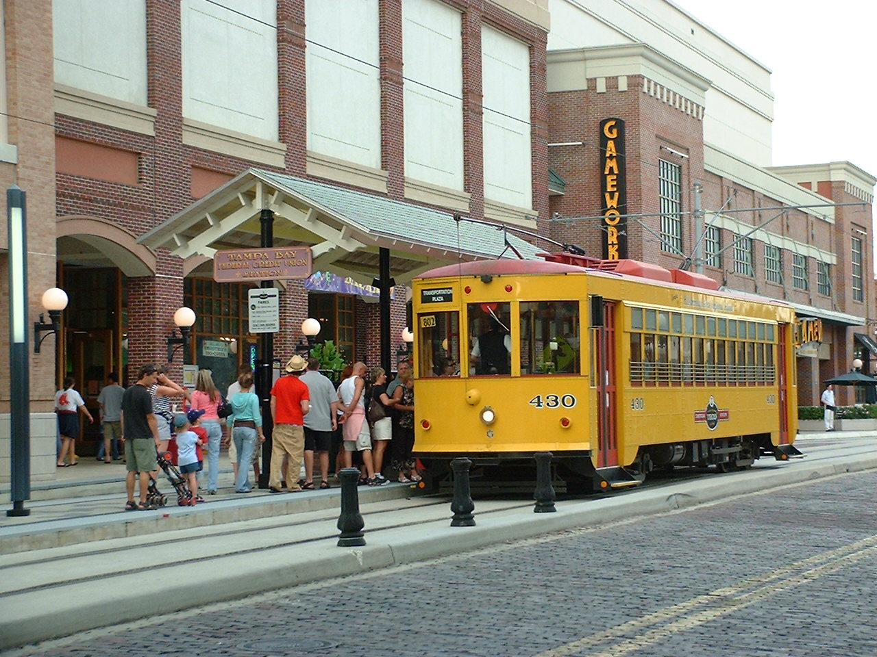
 A TECO streetcar picking up passengers in Ybor City.
Mass transit
Mass transit within Tampa is operated by the Hillsborough Area Regional Transit Authority (HART), and includes a public bus system and a streetcar line. HART has a signed transit deal with the University of South Florida, allowing students to ride for free on most bus routes[25], while students from other schools may receive discounted fares.[26]
In October, 2002, the TECO Line Streetcar System brought electric streetcar service back to Tampa for the first time in over half a century. The line operates from ten stations along a 2.4 mile (3.9 km) route, connecting Ybor City, the Channel District, the Tampa Convention Center, and downtown Tampa[27]. Work is currently underway to extend the line along Franklin Street to the Fort Brooke Parking Garage by December 2010.
Drawing inspiration from the streetcars that traversed Tampa between the late 19th and mid 20th centuries, the TECO line cars include varnished wood interiors and other nostalgic appointments. Though they may appear old-fashioned, the modern fleet of cars are wheelchair accessible and air conditioned, offering increased comfort for Tampa in the 21st-century.[28].
References
- ^ Tampa Parks and Recreation
- ^ District Five
- ^ District Four
- ^ District Six
- ^ Buildings of Tampa
- ^ Regions Building, Tampa
- ^ Bank of America Plaza, Tampa
- ^ One Tampa City Center, Tampa
- ^ SunTrust Financial Centre, Tampa
- ^ Park Tower, Tampa
- ^ Rivergate Tower, Tampa
- ^ Hillsborough County Center, Tampa
- ^ "Fact Sheet", August 24, 2009. Tampa International Airport. Retrieved January 28, 2010.
- ^ "Condé Nast Readers Rate Tampa International Best in the U.S.", March 6, 2003. Tampa International Airport. Retrieved January 28, 2010.
- ^ "NEWS RELEASE: TPA Still Admired After All These Years", September 29, 2008. Tampa International Airport. Retrieved January 28, 2010.
- ^ "Zagat Survey Releases Global Airlines Survey Covering 84 Airlines and 46 Major Airports", November 20, 2007. Zagat Survey. Retrieved January 28, 2010.
- ^ Tampa Port Authority: General Cargo Facilities, Ports America Berths. Retrieved January 21, 2010.
- ^ a b Amtrak Atlantic Coast Service. Retrieved January 21, 2010.
- ^ http://dl.nwrc.gov/net_prod_download/public/gom_net_pub_products/MAP/1879chart_tampa.jpg
- ^ Corps, Port Consider Channel Widening Options
- ^ Tampa Bay Estuary Program - State of the Bay - Dredging & Dredged Material Management
- ^ Tampa Port Authority.
- ^ "Total Port, Port of Tampa, Florida: FY09 vs FY08", November 16, 2009. Tampa Port Authority. Retrieved January 28, 2010.
- ^ "Cruise Sailing Schedule 2009/2010". Tampa Port Authority. Retrieved January 28, 2010.
- ^ "USF UPass." Hillsborough Area Regional Transit. Retrieved on December 17, 2006.
- ^ "Adult Student Fare." Hillsborough Area Regional Transit. Retrieved on December 17, 2006.
- ^ "Streetcar Station Stops", 2007. TECO Line Streetcar System. Retrieved January 28, 2010.
- ^ "What Goes Around Comes Around", 2007. TECO Line Streetcar System. Retrieved January 28, 2010.
See also
History • Flag • Nickname • Metro Area • People • Downtown • Cityscape • Education • Neighborhoods • Mayors • City Council • Sports • Skyscrapers • Law enforcement • Fire Department • Climate • Media • Public Transit • City Seal Categories:
- Cityscapes
- Tampa, Florida


Wikimedia Foundation. 2010.