- Lougheed Island
Infobox Islands
name = Lougheed Island
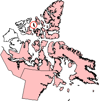
image caption = Lougheed Island, Nunavut
image size =
locator
map_custom =
native name =
native name link = Inuktikut
nickname =
location =Northern Canada
coordinates = coord|77|24|N|105|15|W|display=inline,title
archipelago =Queen Elizabeth Islands Canadian Arctic Archipelago
total islands =
major islands =
area = convert|1308|km2|sqmi|abbr=on
highest mount =
elevation =
country = Canada
country admin divisions title = Territory
country admin divisions = flag|Nunavut
country admin divisions title 1 =Qikiqtaaluk Region
country admin divisions 1 =
country admin divisions title 2 =
country admin divisions 2 =
country capital city =
country largest city =
country largest city population =
country leader title =
country leader name =
population = Uninhabited
population as of =
density =
ethnic groups =
additional info =Lougheed Island is one of the
Canadian arctic islands inNunavut ,Canada . Located at 77°26'N 105°06'W, it measures 1,308 km² in size. It relatively isolated compared to other Canadian Arctic islands, and is located halfway betweenEllef Ringnes Island to the northeast and Melville Island to the southwest.History
Lougheed Island was discovered in 1916 by
Vilhjalmur Stefansson as part of the Canadian Arctic Expedition.On
April 14 ,1993 ,Environment Canada revoked a permit issued toPanarctic Oils Ltd. to dispose of 400 tonnes of scrap metal in the ocean off Lougheed Island. The decision was taken in response to concerns expressed by residents of Grise Fiord, Resolute, Arctic Bay and Pond Inlet. Instead of disposing of the material at sea, a research project was initiated to evaluate the environmental impact of stockpiling scrap metal on Lougheed Island.In 1994, Larry Newitt of the
Geological Survey of Canada and Charles Barton of theAustralian Geological Survey Organization established a temporary magnetic observatory on Lougheed Island, close to the predicted position of theNorth Magnetic Pole , in order to monitor short-term fluctuations of the Earth's magnetic field. [cite web |url=http://obsfur.geophysik.uni-muenchen.de/mag/news/e_nmpole.htm |title=Tracking the North Magnetic Pol |accessdate=2008-05-18 |last=Newitt |first=Larry |coauthors= |date= |work= |publisher=uni-muenchen.de]References
Wikimedia Foundation. 2010.