- Glacier
-
This article is about the geological formation. For other uses, see Glacier (disambiguation).
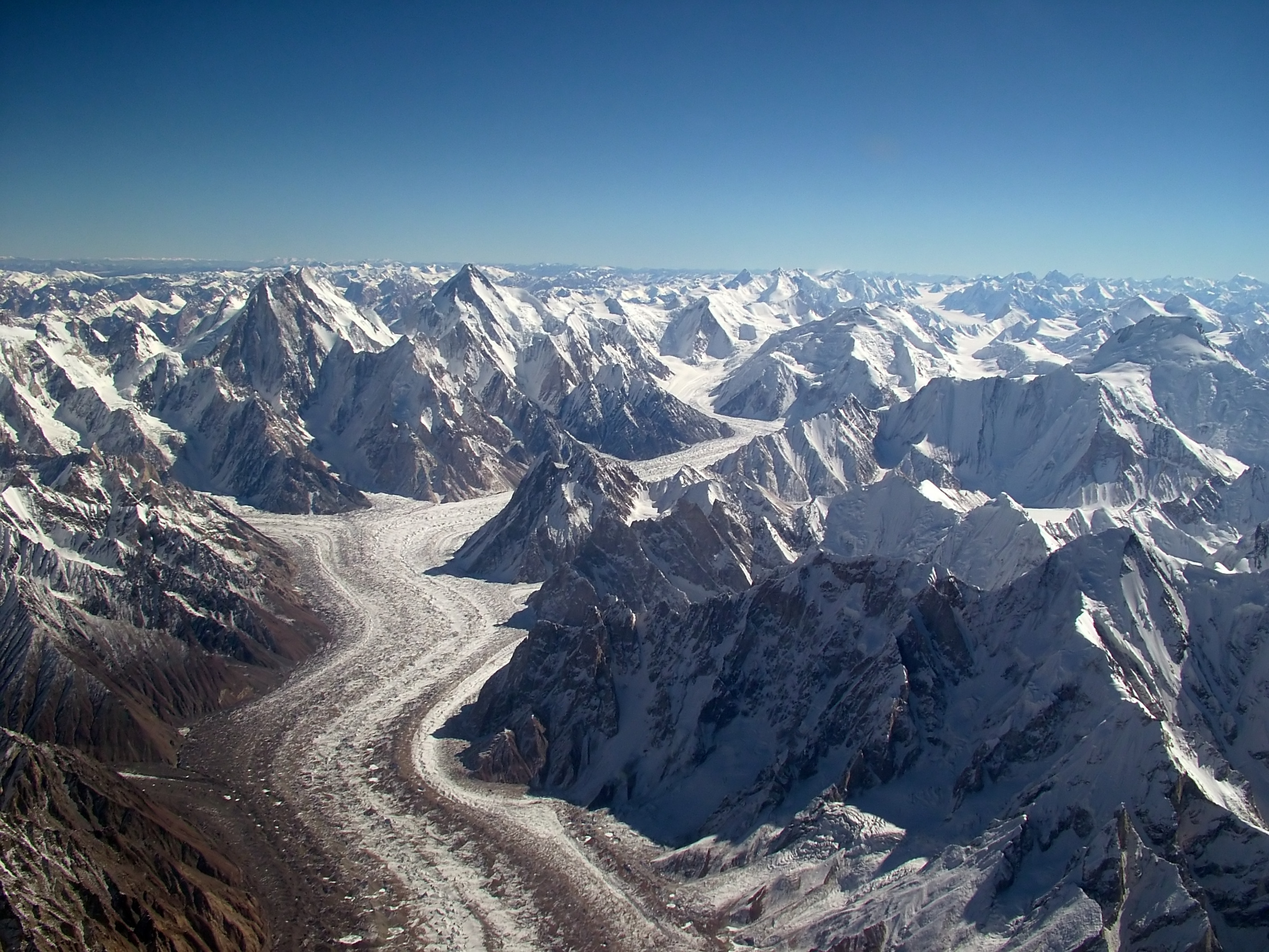
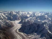 The Baltoro Glacier in the Karakoram, Kashmir, Northern Pakistan. At 62 kilometres (39 mi) in length, it is one of the longest alpine glaciers on earth.


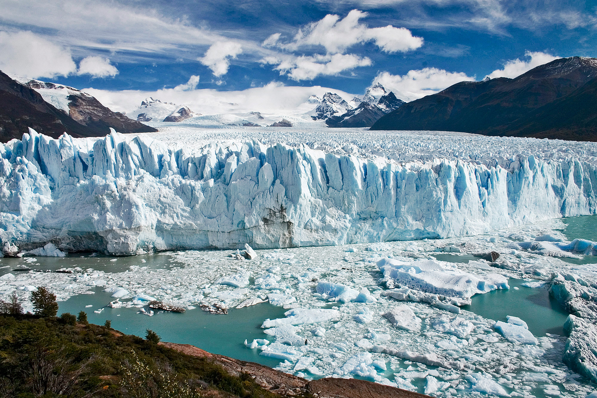
A glacier (pronounced UK: /ˈɡlæsiə/ glass-ee-ər or US: /ˈɡleɪʃər/ glay-shər) is a large persistent body of ice that forms where the accumulation of snow exceeds its ablation (melting and sublimation) over many years, often centuries. At least 0.1 km² in area and 50 m thick, but often much larger, a glacier slowly deforms and flows due to stresses induced by its weight. Crevasses, seracs, and other distinguishing features of a glacier are due to its flow. Another consequence of glacier flow is the transport of rock and debris abraded from its substrate and resultant landforms like cirques and moraines. Glaciers form on land, often elevated, and are distinct from the much thinner sea ice and lake ice that form on the surface of bodies of water.
The word glacier comes from French. It is derived from the Vulgar Latin glacia and ultimately from Latin glacies meaning ice.[1] The processes and features caused by glaciers and related to them are referred to as glacial. The process of glacier establishment, growth and flow is called glaciation. The corresponding area of study is called glaciology. Glaciers are important components of the global cryosphere.
On Earth, 99% of glacial ice is contained within vast ice sheets in the polar regions, but glaciers may be found in mountain ranges of every continent except Australia, and on a few high-latitude oceanic islands. In the tropics, glaciers occur only on high mountains.[2]
Glacial ice is the largest reservoir of freshwater on Earth, supporting one third of the world's population.[3] Many glaciers store water during one season and release it later as meltwater, a water source that is especially important for plants, animals and human uses when other sources may be scant.
Because glacial mass is affected by long-term climate changes, e.g., precipitation, mean temperature, and cloud cover, glacial mass changes are considered among the most sensitive indicators of climate change and are a major source of variations in sea level.
Contents
Types of glaciers
Main article: Glacier morphology Mouth of the Schlatenkees Glacier near Innergschlöß, Austria
Glaciers are categorized in many ways including by their morphology, thermal characteristics or their behavior. Alpine glaciers form on the crests and slopes of mountains and are also known as "mountain glaciers", "niche glaciers", or "cirque glaciers". An alpine glacier that fills a valley is sometimes called a valley glacier. Larger glaciers that cover an entire mountain, mountain range, or volcano are known as an ice cap or ice field, such as the Juneau Icefield.[4] Ice caps feed outlet glaciers, tongues of ice that extend into valleys below far from the margins of the larger ice masses.
The largest glacial bodies, ice sheets or continental glaciers, cover more than 50,000 km² (20,000 mile²).[5] Several kilometers deep, they obscure the underlying topography. Only nunataks protrude from the surface. The only extant ice sheets are the two that cover most of Antarctica and Greenland. These regions contain vast quantities of fresh water. The volume of ice is so large that if the Greenland ice sheet melted, it would cause sea levels to rise six meters (20 ft) all around the world. If the Antarctic ice sheet melted, sea levels would rise up to 65 meters (210 ft).[6] Ice shelves are areas of floating ice, commonly located at the margin of an ice sheet. As a result they are thinner and have limited slopes and reduced velocities.[7] Ice streams are fast-moving sections of an ice sheet.[8] They can be several hundred kilometers long. Ice streams have narrow margins and on either side ice flow is usually an order of magnitude less.[9] In Antarctica, many ice streams drain into large ice shelves. However, some drain directly into the sea, often with an ice tongue, like Mertz Glacier. In Greenland and Antarctica ice streams ending at the sea are often referred to as tidewater glaciers or outlet glaciers, such as Jakobshavn Isbræ (Kalaallisut: Sermeq Kujalleq).
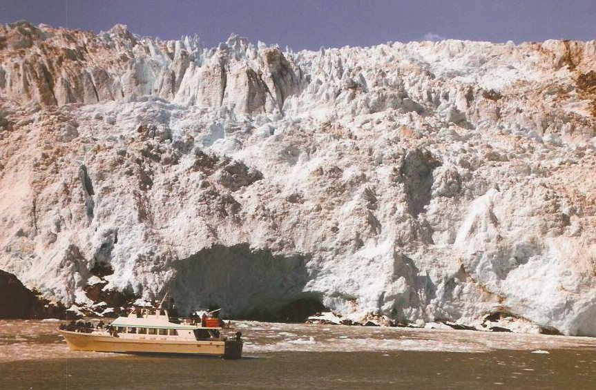
 Sightseeing boat in front of a tidewater glacier, Kenai Fjords National Park, Alaska
Tidewater glaciers are glaciers that terminate in the sea. As the ice reaches the sea pieces break off, or calve, forming icebergs. Most tidewater glaciers calve above sea level, which often results in a tremendous splash as the iceberg strikes the water. If the water is deep, glaciers can calve underwater, causing the iceberg to suddenly leap up out of the water. The Hubbard Glacier is the longest tidewater glacier in Alaska and has a calving face over 10 km (6.2 mi) long. Yakutat Bay and Glacier Bay are both popular with cruise ship passengers because of the huge glaciers descending hundreds of feet to the water. This glacier type undergoes centuries-long cycles of advance and retreat that are much less affected by the climate changes currently causing the retreat of most other glaciers. Most tidewater glaciers are outlet glaciers of ice caps and ice fields.
In terms of thermal characteristics, a temperate glacier is at melting point throughout the year, from its surface to its base. The ice of a polar glacier is always below freezing point from the surface to its base, although the surface snowpack may experience seasonal melting. A sub-polar glacier has both temperate and polar ice, depending on the depth beneath the surface and position along the length of the glacier.
Formation
 Gorner Glacier in Switzerland
Glaciers form where the accumulation of snow and ice exceeds ablation. As the snow and ice thicken, they reach a point where they begin to move, due to a combination of the surface slope and the pressure of the overlying snow and ice. On steeper slopes this can occur with as little as 15 m (50 ft) of snow-ice. The snow which forms temperate glaciers is subject to repeated freezing and thawing, which changes it into a form of granular ice called firn. Under the pressure of the layers of ice and snow above it, this granular ice fuses into denser and denser firn. Over a period of years, layers of firn undergo further compaction and become glacial ice. Glacier ice has a slightly reduced density from ice formed from the direct freezing of water. The air between snowflakes becomes trapped and creates air bubbles between the ice crystals.
The distinctive blue tint of glacial ice is due to its slight absorption of red light due to an overtone of the infrared OH stretching mode of the water molecule. Liquid water is blue for the same reason. However, the blue of glacier ice is sometimes misattributed to Rayleigh scattering due to bubbles in the ice.[10]
Anatomy
The location where a glacier originates is referred to as the "glacier head". A glacier terminates at the "glacier foot", or terminus. Glaciers are broken into zones based on surface snowpack and melt conditions.[11] The ablation zone is the region where there is a net loss in glacier mass. The equilibrium line separates the ablation zone and the accumulation zone. At this altitude, the amount of new snow gained by accumulation is equal to the amount of ice lost through ablation. The accumulation zone is the region where snowpack or superimposed ice accumulation persists.
A further zonation of the accumulation zone distinguishes the melt conditions that exist.
- The dry snow zone is a region where no melt occurs, even in the summer, and the snowpack remains dry.
- The percolation zone is an area with some surface melt, causing meltwater to percolate into the snowpack. This zone is often marked by refrozen ice lenses, glands, and layers. The snowpack also never reaches melting point.
- Near the equilibrium line on some glaciers, a superimposed ice zone develops. This zone is where meltwater refreezes as a cold layer in the glacier, forming a continuous mass of ice.
- The wet snow zone is the region where all of the snow deposited since the end of the previous summer has been raised to 0 °C.
The upper part of a glacier that receives most of the snowfall is called the accumulation zone. In general, the glacier accumulation zone accounts for 60-70% of the glacier's surface area, more if the glacier calves icebergs. The depth of ice in the accumulation zone exerts a downward force sufficient to cause deep erosion of the rock in this area. After the glacier is gone, its force often leaves a bowl or amphitheater-shaped isostatic depression ranging from large lake basins, such as the Great Lakes or Finger Lakes, to smaller mountain basins, known as cirques.
The "health" of a glacier is usually assessed by determining the glacier mass balance or observing terminus behavior. Healthy glaciers have large accumulation zones, more than 60% of their area snowcovered at the end of the melt season, and a terminus with vigorous flow.
Following the Little Ice Age, around 1850, the glaciers of the Earth have retreated substantially through the 1940s (see Retreat of glaciers since 1850). A slight cooling led to the advance of many alpine glaciers from 1950-1985. However, since 1985 glacier retreat and mass balance loss has become increasingly ubiquitous and large.[12][13][14]
Motion
 The Nadelhorn Glacier above Saas-Fee, Valais, SwitzerlandMain article: Ice sheet dynamics
Glaciers move, or flow, downhill due to the internal deformation of ice and gravity.[15] Ice behaves like an easily breaking solid until its thickness exceeds about 50 meters (160 ft). The pressure on ice deeper than that depth causes plastic flow. At the molecular level, ice consists of stacked layers of molecules with relatively weak bonds between the layers. When the stress of the layer above exceeds the inter-layer binding strength, it moves faster than the layer below.[16]
Another type of movement is through basal sliding. In this process, the glacier slides over the terrain on which it sits, lubricated by the presence of liquid water. As the pressure increases toward the base of the glacier, the melting point of water decreases, and the ice melts. Friction between ice and rock and geothermal heat from the Earth's interior also contribute to melting. This type of movement is dominant in temperate, or warm-based glaciers. The geothermal heat flux becomes more important the thicker a glacier becomes.[17]
The rate of movement is dependent on the underlying slope, amongst many other factors.
Fracture zone and cracks
 Ice cracks in the Titlis Glacier
 Signs warning of the hazards of a glacier in New Zealand
The top 50 meters of the glacier, being under less pressure, are more rigid; this section is known as the fracture zone, and mostly moves as a single unit, over the plastic-like flow of the lower section. When the glacier moves through irregular terrain, cracks up to 50 meters deep form in the fracture zone. The lower layers of glacial ice flow and deform plastically under the pressure, allowing the glacier as a whole to move slowly like a viscous fluid. Glaciers flow downslope, usually this reflects the slope of their base, but it may reflect the surface slope instead. Thus, a glacier can flow rises in terrain at their base. The upper layers of glaciers are more brittle, and often form deep cracks known as crevasses. The presence of crevasses is a sure sign of a glacier. Moving ice-snow of a glacier is often separated from a mountain side or snow-ice that is stationary and clinging to that mountain side by a bergshrund. This looks like a crevasse but is at the margin of the glacier and is a singular feature.
Crevasses form due to differences in glacier velocity. As the parts move at different speeds and directions, shear forces cause the two sections to break apart, opening the crack of a crevasse all along the disconnecting faces. Hence, the distance between the two separated parts, while touching and rubbing deep down, frequently widens significantly towards the surface layers, many times creating a wide chasm. Intersecting crevasses may create isolated peaks in the ice, called a serac.
Crevasses seldom are more than 150 feet (46 m) deep but in some cases can be 1,000 feet (300 m) or even deeper. Beneath this point, the plastic deformation of the ice under pressure is too great for the differential motion to generate cracks. Transverse crevasses are transverse to flow, as a glacier accelerates where the slope steepens. Longitudinal crevasses form semi-parallel to flow where a glacier expands laterally. Marginal crevasses form from the edge of the glacier, due to the reduction in speed caused by friction of the valley walls. Marginal crevasses are usually largely transverse to flow.

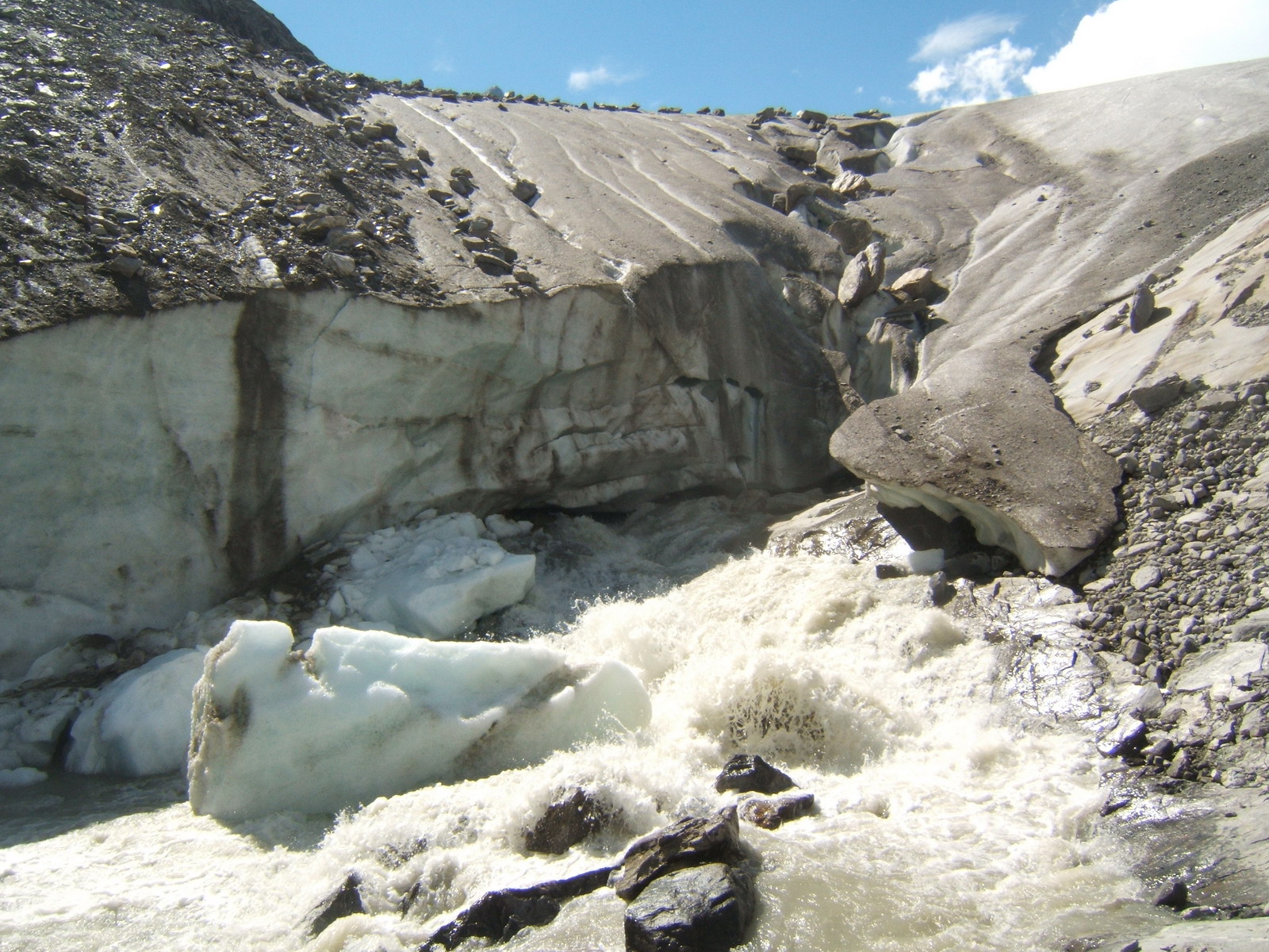
Crevasses make travel over glaciers hazardous. Subsequent heavy snow may form fragile snow bridges, increasing the danger by hiding the presence of crevasses at the surface. Below the equilibrium line, glacier meltwater is concentrated in stream channels. The meltwater can pool in a proglacial lake, a lake on top of the glacier, or can descend into the depths of the glacier via moulins. Within or beneath the glacier, the stream will flow in an englacial or sub-glacial tunnel. Sometimes these tunnels reemerge at the surface of the glacier.[18]
Speed
The speed of glacial displacement is partly determined by friction. Friction makes the ice at the bottom of the glacier move more slowly than the upper portion. In alpine glaciers, friction is also generated at the valley's side walls, which slows the edges relative to the center. This was confirmed by experiments in the 19th century, in which stakes were planted in a line across an alpine glacier, and as time passed, those in the center moved farther.
Mean speeds vary greatly. There may be no motion in stagnant areas, where trees can establish themselves on surface sediment deposits such as in Alaska. In other cases they can move as fast as 20–30 meters per day, as in the case of Greenlands's Jakobshavn Isbræ (Kalaallisut: Sermeq Kujalleq), or 2–3 m per day on Byrd Glacier, the largest glacier in the world in Antarctica. Velocity increases with increasing slope, increasing thickness, increasing snowfall, increasing longitudinal confinement, increasing basal temperature, increasing meltwater production and reduced bed hardness.
A few glaciers have periods of very rapid advancement called surges. These glaciers exhibit normal movement until suddenly they accelerate, then return to their previous state. During these surges, the glacier may reach velocities far greater than normal speed.[19] These surges may be caused by failure of the underlying bedrock, the ponding of meltwater at the base of the glacier[20] — perhaps delivered from a supraglacial lake — or the simple accumulation of mass beyond a critical "tipping point".[21]
In glaciated areas where the glacier moves faster than one kilometer per year, glacial earthquakes occur. These are large scale tremblors that have seismic magnitudes as high as 6.1.[22][23]
The number of glacial earthquakes in Greenland show a peak every year in July, August and September, and the number is increasing over time. In a study using data from January 1993 through October 2005, more events were detected every year since 2002, and twice as many events were recorded in 2005 as there were in any other year. This increase in the numbers of glacial earthquakes in Greenland may be a response to global warming.[22][23]
Seismic waves are also generated by the Whillans Ice Stream, a large, fast-moving river of ice pouring from the West Antarctic Ice Sheet into the Ross Ice Shelf. Two bursts of seismic waves are released every day, each one equivalent to a magnitude 7 earthquake, and are seemingly related to the tidal action of the Ross Sea. During each event a 96 by 193 kilometer (60 by 120 mile) region of the glacier moves as much as .67 meters (2.2 ft) over about 25 minutes, remains still for 12 hours, then moves another half-meter. The seismic waves are recorded at seismographs around Antarctica, and even as far away as Australia, a distance of more than 6,400 kilometers. Because the motion takes place of such along period of time 10 to 25 minutes, it cannot be felt by scientists standing on the moving glacier. It is not known if these events are related to global warming[24]
Ogives
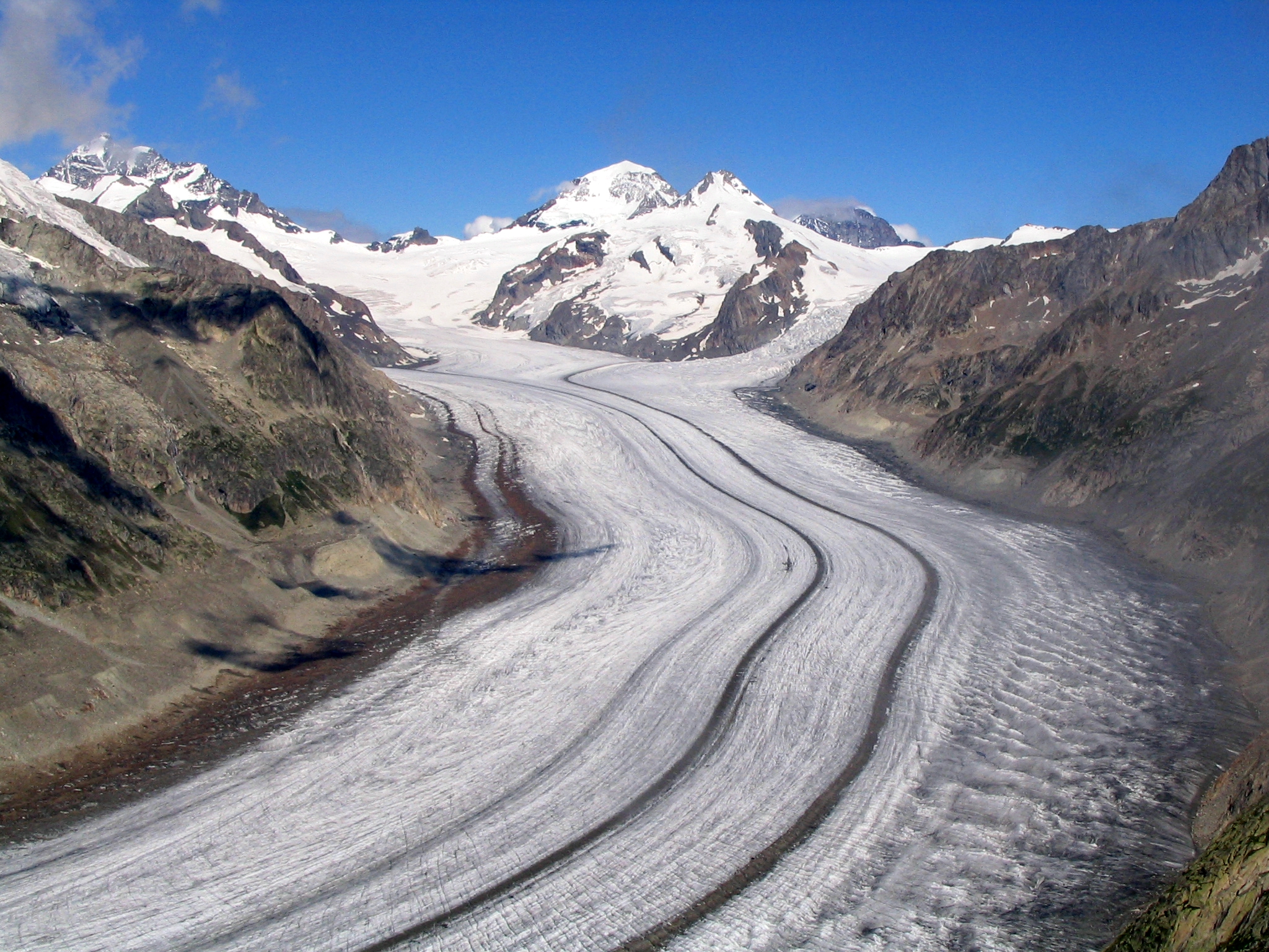
Ogives are alternating dark and light bands of ice occurring as narrow wave crests and wave valleys on glacier surfaces. They only occur below icefalls, but not all icefalls have ogives below them. Once formed, they bend progressively downglacier due to the increased velocity toward the glacier's centerline. Ogives are linked to seasonal motion of the glacier as the width of one dark and one light band generally equals the annual movement of the glacier. The ridges and valleys are formed because ice from an icefall is severely broken up, thereby increasing ablation surface area during the summertime. This creates a swale and space for snow accumulation in the winter, which in turn creates a ridge.[25] Sometimes ogives are described as either wave ogives or band ogives, in which they are solely undulations or varying color bands, respectively.[26]
Geography
For more details on this topic, see List of glaciers.For more details on this topic, see Retreat of glaciers since 1850. Black ice glacier near Aconcagua, Argentina
Glaciers are known on every continent and approximately fifty countries, a count excluding those (Australia, South Africa) that have glaciers only on distant subantarctic island territories. Extensive glaciers are found in Antarctica, Chile, Canada, Alaska, Greenland and Iceland. Mountain glaciers are widespread, e.g., in the Andes, the Himalaya, the Rocky Mountains, the Caucasus, and the Alps. On mainland Australia no glaciers exist today, although a small glacier on Mount Kosciuszko was present in the last glacial period, and Tasmania was extensively glaciated.[27] In New Guinea, small, rapidly diminishing, glaciers are located on its highest summit massif of Puncak Jaya.[28] Africa has glaciers on Mount Kilimanjaro in Tanzania, on Mount Kenya and in the Ruwenzori Range. The South Island of New Zealand has many glaciers including Tasman, Fox and Franz Josef Glaciers.
Among oceanic islands glaciers occur today on Iceland, Svalbard, Jan Mayen and the subantarctic islands of Marion, Heard, Grande Terre and Bouvet. During glacial periods of the Quaternary Taiwan, Hawaii on Mauna Kea[29] and Tenerife also had large alpine glaciers, whilst the Faroe and Crozet Islands[30] were completely glaciated.
Permanent snow cover is affected by factors such as the degree of slope on the land, amount of snowfall and the winds. As temperature decreases with altitude, high mountains — even those near the equator — have permanent snow cover on their upper portions, above the snow line. Examples include Mount Kilimanjaro and the Tropical Andes in South America; however, the only snow to occur exactly on the Equator is at 4,690 m (15,387 ft) on the southern slope of Volcán Cayambe in Ecuador.
Conversely, areas of the Arctic, such as Banks Island, and the McMurdo Dry Valleys in Antarctica are considered polar deserts, as they receive little snowfall despite the bitter cold. Cold air, unlike warm air, is unable to transport much water vapor. Even during glacial periods of the Quaternary, Manchuria, lowland Siberia,[31] and central and northern Alaska,[32] though extraordinarily cold had such light snowfall that glaciers could not form.[33][34]
In addition to the dry, unglaciated polar regions, some mountains and volcanoes in Bolivia, Chile and Argentina are high (4,500 metres (14,800 ft) - 6,900 m (22,600 ft)) and cold, but the relative lack of precipitation prevents snow from accumulating into glaciers. This is because these peaks are located near or in the hyperarid Atacama desert.
Glacial geology
 Diagram of glacial plucking and abrasion
 Glacially plucked granitic bedrock near Mariehamn, Åland Islands
Rocks and sediments are added to glaciers through various processes. Glaciers erode the terrain principally through two methods: abrasion and plucking.
As the glacier flows over the bedrock's fractured surface, it softens and lifts blocks of rock that are brought into the ice. This process is known as plucking, and it is produced when subglacial water penetrates the fractures and the subsequent freezing expansion separates them from the bedrock. When the ice expands, it acts as a lever that loosens the rock by lifting it. This way, sediments of all sizes become part of the glacier's load. The rocks frozen into the bottom of the ice then act like grit in sandpaper.
Abrasion occurs when the ice and the load of rock fragments slide over the bedrock and function as sandpaper that smooths and polishes the surface situated below. This pulverized rock is called rock flour. The flour is formed by rock grains of a size between 0.002 and 0.00625 mm. Sometimes the amount of rock flour produced is so high that currents of meltwaters acquire a grayish color. These processes of erosion lead to steeper valley walls and mountain slopes in alpine settings, which can cause avalanches and rock slides. These further add material to the glacier.
Visible characteristics of glacial abrasion are glacial striations. These are produced when the bottom's ice contains large chunks of rock that mark scratches in the bedrock. By mapping the direction of the flutes, researchers can determine the direction of the glacier's movement. Chatter marks are seen as lines of roughly crescent-shape depressions in the rock underlying a glacier, caused by the abrasion where a boulder in the ice catches and is then released repetitively as the glacier drags it over the underlying basal rock.
The rate of glacier erosion is variable. The differential erosion undertaken by the ice is controlled by six important factors:
- Velocity of glacial movement;
- Thickness of the ice;
- Shape, abundance and hardness of rock fragments contained in the ice at the bottom of the glacier;
- Relative ease of erosion of the surface under the glacier;
- Thermal conditions at the glacier base; and
- Permeability and water pressure at the glacier base.
Material that becomes incorporated in a glacier are typically carried as far as the zone of ablation before being deposited. Glacial deposits are of two distinct types:
- Glacial till: material directly deposited from glacial ice. Till includes a mixture of undifferentiated material ranging from clay size to boulders, the usual composition of a moraine.
- Fluvial and outwash: sediments deposited by water. These deposits are stratified through various processes, such as boulders' being separated from finer particles.
The larger pieces of rock which are encrusted in till or deposited on the surface are called "glacial erratics". They may range in size from pebbles to boulders, but as they may be moved great distances, they may be of drastically different type than the material upon which they are found. Patterns of glacial erratics provide clues of past glacial motions.
Moraines

Glacial moraines are formed by the deposition of material from a glacier and are exposed after the glacier has retreated. These features usually appear as linear mounds of till, a non-sorted mixture of rock, gravel and boulders within a matrix of a fine powdery material. Terminal or end moraines are formed at the foot or terminal end of a glacier. Lateral moraines are formed on the sides of the glacier. Medial moraines are formed when two different glaciers, flowing in the same direction, coalesce and the lateral moraines of each combine to form a moraine in the middle of the merged glacier. Less apparent is the ground moraine, also called glacial drift, which often blankets the surface underneath much of the glacier downslope from the equilibrium line. Glacial meltwaters contain rock flour, an extremely fine powder ground from the underlying rock by the glacier's movement. Other features formed by glacial deposition include long snake-like ridges formed by streambeds under glaciers, known as eskers, and distinctive streamlined hills, known as drumlins.
Stoss-and-lee erosional features are formed by glaciers and show the direction of their movement. Long linear rock scratches (that follow the glacier's direction of movement) are called glacial striations, and divots in the rock are called chatter marks. Both of these features are left on the surfaces of stationary rock that were once under a glacier and were formed when loose rocks and boulders in the ice were transported over the rock surface. Transport of fine-grained material within a glacier can smooth or polish the surface of rocks, leading to glacial polish. Glacial erratics are rounded boulders that were left by a melting glacier and are often seen perched precariously on exposed rock faces after glacial retreat.
The term moraine is of French origin. It was coined by peasants to describe alluvial embankments and rims found near the margins of glaciers in the French Alps. In modern geology, the term is used more broadly, and is applied to a series of formations, all of which are composed of till.
Drumlins
 A drumlin field forms after a glacier has modified the landscape. The teardrop-shaped formations denote the direction of the ice flow.
Drumlins are asymmetrical, canoe shaped hills with aerodynamic profiles made mainly of till. Their heights vary from 15 to 50 meters and they can reach a kilometer in length. The tilted side of the hill looks toward the direction from which the ice advanced (stoss), while the longer slope follows the ice's direction of movement (lee).
Drumlins are found in groups called drumlin fields or drumlin camps. An example of these fields is found east of Rochester, New York, and it is estimated that it contains about 10,000 drumlins.
Although the process that forms drumlins is not fully understood, it can be inferred from their shape that they are products of the plastic deformation zone of ancient glaciers. It is believed that many drumlins were formed when glaciers advanced over and altered the deposits of earlier glaciers.
Glacial valleys
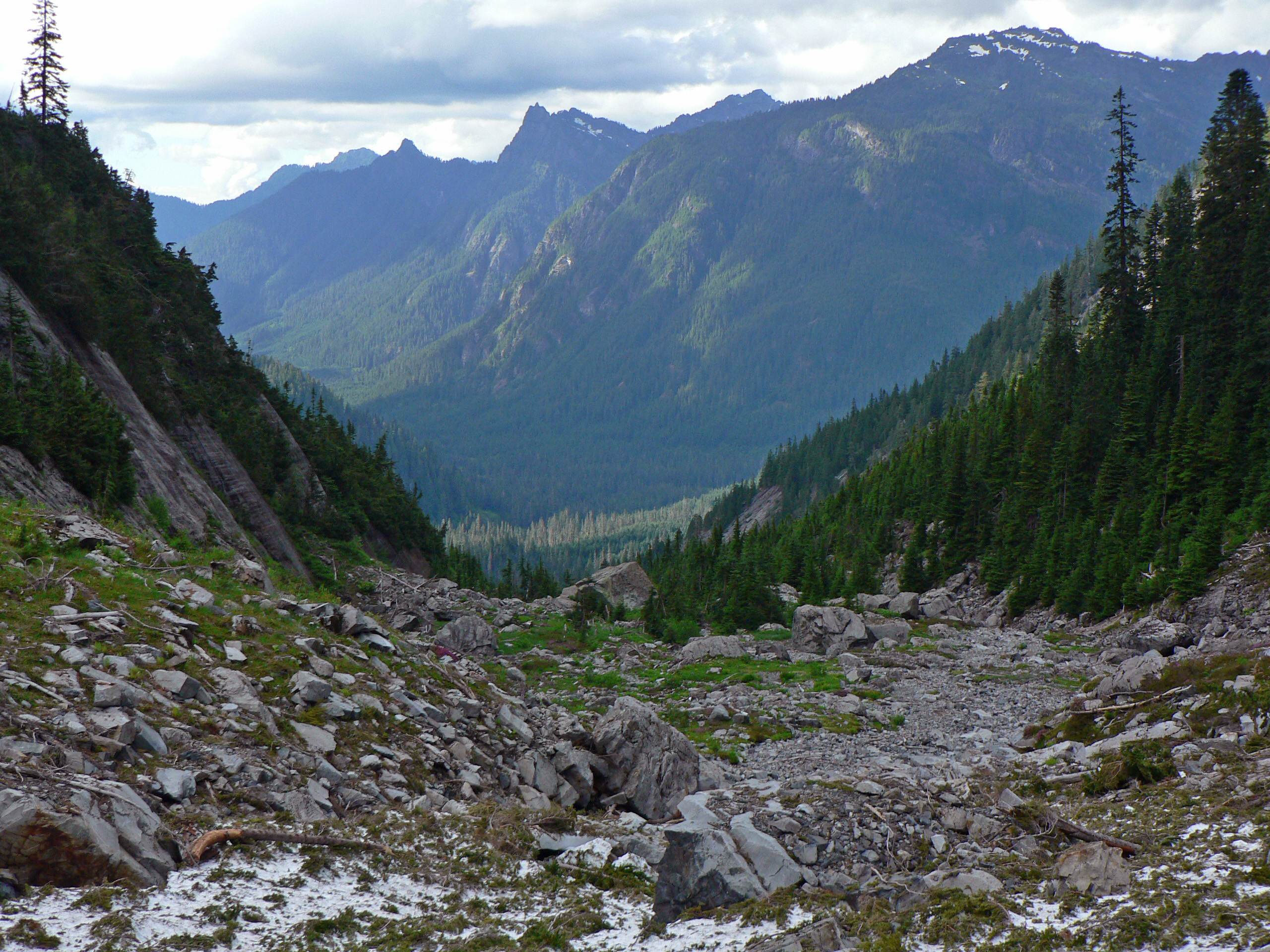
 A glacial valley in the Mount Baker-Snoqualmie National Forest, showing the characteristic U-shape and flat bottom
 Yosemite Valley from an airplane, showing the U-shape
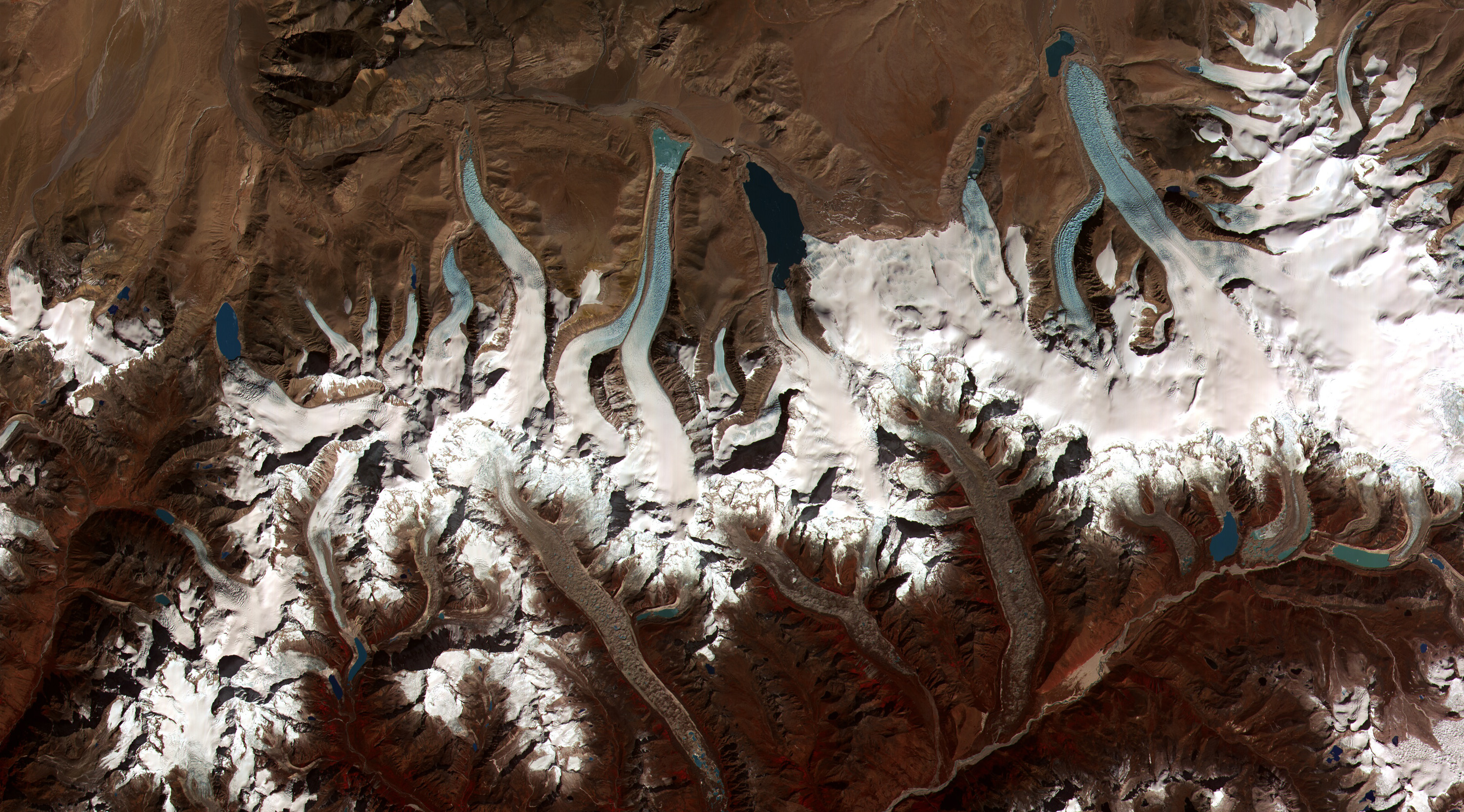
 This image shows the termini of the glaciers in the Bhutan Himalaya. Glacial lakes have been rapidly forming on the surface of the debris-covered glaciers in this region during the last few decades.
Before glaciation, mountain valleys have a characteristic "V" shape, produced by downward erosion by water. However, during glaciation, these valleys widen and deepen, forming a "U"-shaped glacial valley. Besides the deepening and widening of the valley, the glacier also smooths the valley due to erosion. In this way, it eliminates the spurs of earth that extend across the valley. Because of this interaction, triangular cliffs called truncated spurs are formed.
Many glaciers deepen their valleys more than their smaller tributaries. Therefore, when the glaciers recede from the region, the valleys of the tributary glaciers remain above the main glacier's depression, and these are called hanging valleys.
In parts of the soil that were affected by abrasion and plucking, the depressions left can be filled by lakes, called paternoster lakes.
At the 'start' of a classic valley glacier is the cirque, which has a bowl shape with escarped walls on three sides, but open on the side that descends into the valley. In the cirque, an accumulation of ice is formed. These begin as irregularities on the side of the mountain, which are later augmented in size by the coining of the ice. Once the glacier melts, these corries are usually occupied by small mountain lakes called tarns.
There may be two glacial cirques 'back to back' which erode deep into their backwalls until only a narrow ridge, called an arête is left. This structure may result in a mountain pass.
Glaciers are also responsible for the creation of fjords (deep coves or inlets) and escarpments that are found at high latitudes.
 Features of a glacial landscape
Arêtes and horns (pyramid peak)
An arête is a narrow crest with a sharp edge. The meeting of three or more arêtes creates pointed pyramidal peaks and in extremely steep-sided forms these are called horns.
Both features may have the same process behind their formation: the enlargement of cirques from glacial plucking and the action of the ice. Horns are formed by cirques that encircle a single mountain.
Arêtes emerge in a similar manner; the only difference is that the cirques are not located in a circle, but rather on opposite sides along a divide. Arêtes can also be produced by the collision of two parallel glaciers. In this case, the glacial tongues cut the divides down to size through erosion, and polish the adjacent valleys.
Roche moutonnée
Some rock formations in the path of a glacier are sculpted into small hills with a shape known as roche moutonnée or "sheepback" rock. An elongated, rounded, asymmetrical, bedrock knob can be produced by glacier erosion. It has a gentle slope on its up-glacier side and a steep to vertical face on the down-glacier side. The glacier abrades the smooth slope that it flows along, while rock is torn loose from the downstream side and carried away in ice, a process known as 'plucking'. Rock on this side is fractured by a combination of various forces, such as water, ice in rock cracks, and structural stresses.
Alluvial stratification
The water that rises from the ablation zone moves away from the glacier and carries with it fine eroded sediments. As the speed of the water decreases, so does its capacity to carry objects in suspension. The water then gradually deposits the sediment as it runs, creating an alluvial plain. When this phenomenon occurs in a valley, it is called a valley train. When the deposition is to an estuary, the sediments are known as "bay mud".
 Landscape produced by a receding glacier
Outwash plains and valley trains are usually accompanied by basins known as "kettles". These are glacial depressions produced when large ice blocks are stuck in the glacial alluvium. After they melt, the sediment is left with holes. The diameter of such depressions ranges from 5 m to 13 km, with depths of up to 45 meters. Most are circular in shape due to the melting blocks of ice becoming rounded. The lakes that often form in these depressions are known as "kettle lakes".[35]
Deposits in contact with ice
When a glacier reduces in size to a critical point, its flow stops, and the ice becomes stationary. Meanwhile, meltwater flows over, within, and beneath the ice leave stratified alluvial deposits. Because of this, as the ice melts, it leaves stratified deposits in the form of columns, terraces and clusters. These types of deposits are known as "deposits in contact with ice".
When those deposits take the form of columns of tipped sides or mounds, they are called kames. Some kames form when meltwater deposits sediments through openings in the interior of the ice. In other cases, they are just the result of fans or deltas towards the exterior of the ice produced by meltwater. When the glacial ice occupies a valley, it can form terraces or kame along the sides of the valley.
A third type of deposit formed in contact with the ice is characterized by long, narrow sinuous crests, composed fundamentally of sand and gravel deposited by streams of meltwater flowing within, or beneath the glacier. After the ice has melted, these linear ridges or eskers remain as landscape features. Some of these crests have heights exceeding 100 meters and their lengths surpass 100 km.
Loess deposits
Very fine glacial sediments or rock flour is often picked up by wind blowing over the bare surface and may be deposited great distances from the original fluvial deposition site. These eolian loess deposits may be very deep, even hundreds of meters, as in areas of China and the Midwestern United States of America. Katabatic winds can be important in this process.
Transportation and erosion
- Entrainment is the picking up of loose material by the glacier from along the bed and valley sides. Entrainment can happen by regelation or by the ice simply picking up the debris.
- Basal ice freezing is thought to be to be made by glaciohydraulic supercooling, though some studies show that even where physical conditions allow it to occur, the process may not be responsible for observed sequences of basal ice.
- Plucking is the process involves the glacier freezing onto the valley sides and subsequent ice movement pulling away masses of rock. As the bedrock is greater in strength than the glacier, only previously loosened material can be removed. It can be loosened by local pressure and temperature, water and pressure release of the rock itself.
- Supraglacial debris is carried on the surface of the glacier as lateral and medial moraines. In summer ablation, surface melt water carries a small load and this often disappears down crevasses.
- Englacial debris is moraine carried within the body of the glacier.
- Subglacial debris is moved along the floor of the valley either by the ice as ground moraine or by meltwater streams formed by pressure melting.
Deposition
- Lodgement till is identical to ground moraine. It is material that is smeared on to the valley floor when its weight becomes too great to be moved by the glacier.
- Ablation till is a combination of englacial and supraglacial moraine. It is released as a stationary glacier begins to melt and material is dropped in situ.
- Dumping is when a glacier moves material to its outermost or lowermost end and dumps it.
- Deformation flow is the change of shape of the rock and land due to the glacier.
Isostatic rebound
Main article: Isostatic rebound Isostatic pressure by a glacier on the Earth's crust
This rise of a part of the crust is due to an isostatic adjustment. A large mass, such as an ice sheet/glacier, depresses the crust of the Earth and displaces the mantle below. The depression is about a third the thickness of the ice sheet. After the glacier melts the mantle begins to flow back to its original position pushing the crust back to its original position. This post-glacial rebound, which lags melting of the ice sheet/glacier, is currently occurring in measurable amounts in Scandinavia and the Great Lakes region of North America.
An interesting geomorphological feature created by the same process, but on a smaller scale, is known as dilation-faulting. It occurs within rock where previously compressed rock is allowed to return to its original shape, but more rapidly than can be maintained without faulting, leading to an effect similar to that which would be seen if the rock were hit by a large hammer. This can be observed in recently de-glaciated parts of Iceland and Cumbria.
Glaciers on Mars
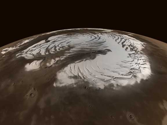
 Northern polar icecap on Mars
Elsewhere in the solar system, the polar ice caps of Mars show glacial features. Especially the south polar cap is compared to glaciers on Earth.[36] Other glacial features on Mars are glacial debris aprons and the lineated valley fills of the fretted terrain in northern Arabia Terra.[37] Topographical features and computer models indicate the existence of more glaciers in Mars' past.[38]
Martian glaciers are affected by the thin atmosphere of Mars. Because of the low atmospheric pressure, ablation near the surface is solely due to sublimation, not melting. As on Earth, many glaciers are covered with a layer of rocks which insulates the ice. A radar instrument onboard the Mars Reconnaisance Orbiter found ice under a thin layer of rocks in formations called Lobate Debris Aprons (LDA's).[39][40][41][42][43]
-
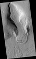
Gullies in a crater in Eridania quadrangle, north of the large crater Kepler. Also, features that may be remains of old glaciers are present. One, to the right, has the shape of a tongue. Image was taken by the Mars Global Surveyor under the Public Target program.
-
Lobate Debris Apron in Phlegra Montes, Cebrenia quadrangle. The debris apron is probably mostly ice with a thin covering of rock debris, so it could be a source of water for future Martian colonists. Scale bar is 500 meters long. Image was obtained by HiRISE.
-
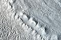
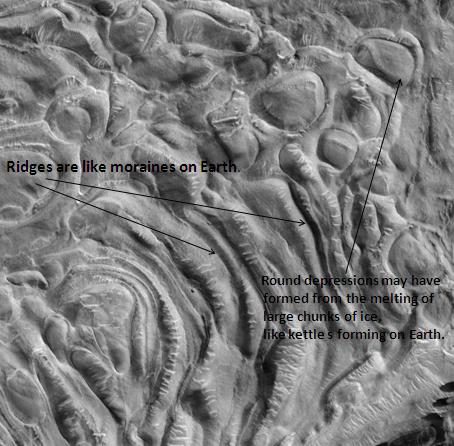
Moreux Crater moraines and kettle holes, as seen by HiRISE. Location is Ismenius Lacus quadrangle.
-

Mesa in Ismenius Lacus quadrangle, as seen by CTX. Mesa has several glaciers eroding it. One of the glaciers is seen in greater detail in the next two images from HiRISE.
-
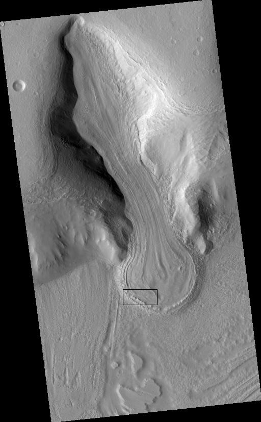
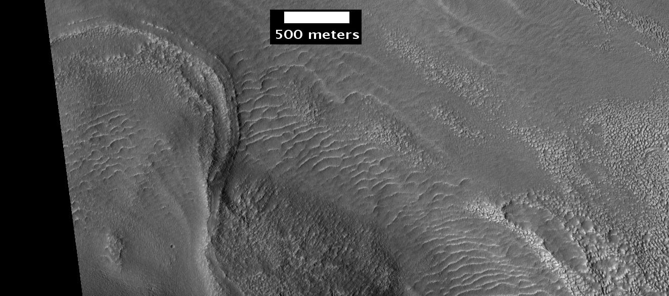
Glacier as seen by HiRISE under the HiWish program. Area in rectangle is enlarged in the next photo. Zone of accumulation of snow at the top. Glacier is moving down valley, then spreading out on plain. Evidence for flow comes from the many lines on surface. Location is in Protonilus Mensae in Ismenius Lacus quadrangle.
-
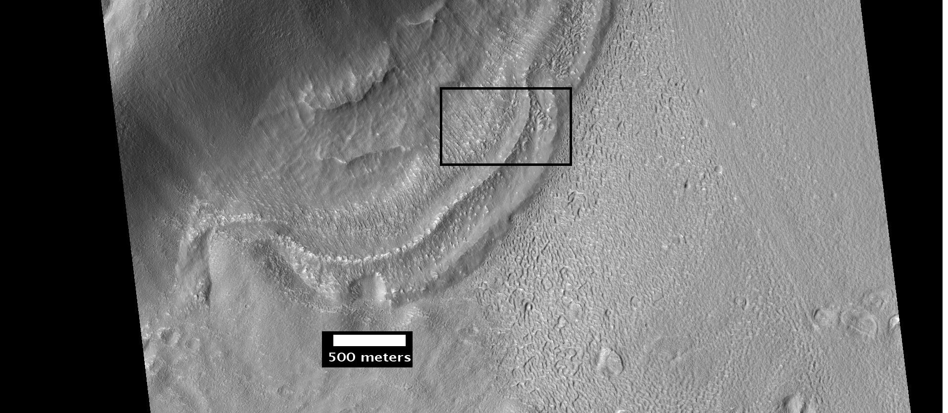
Enlargement of area in rectangle of the previous image. On Earth the ridge would be called the terminal moraine of an alpine glacier. Picture taken with HiRISE under the HiWish program. Location is Ismenius Lacus quadrangle.
-

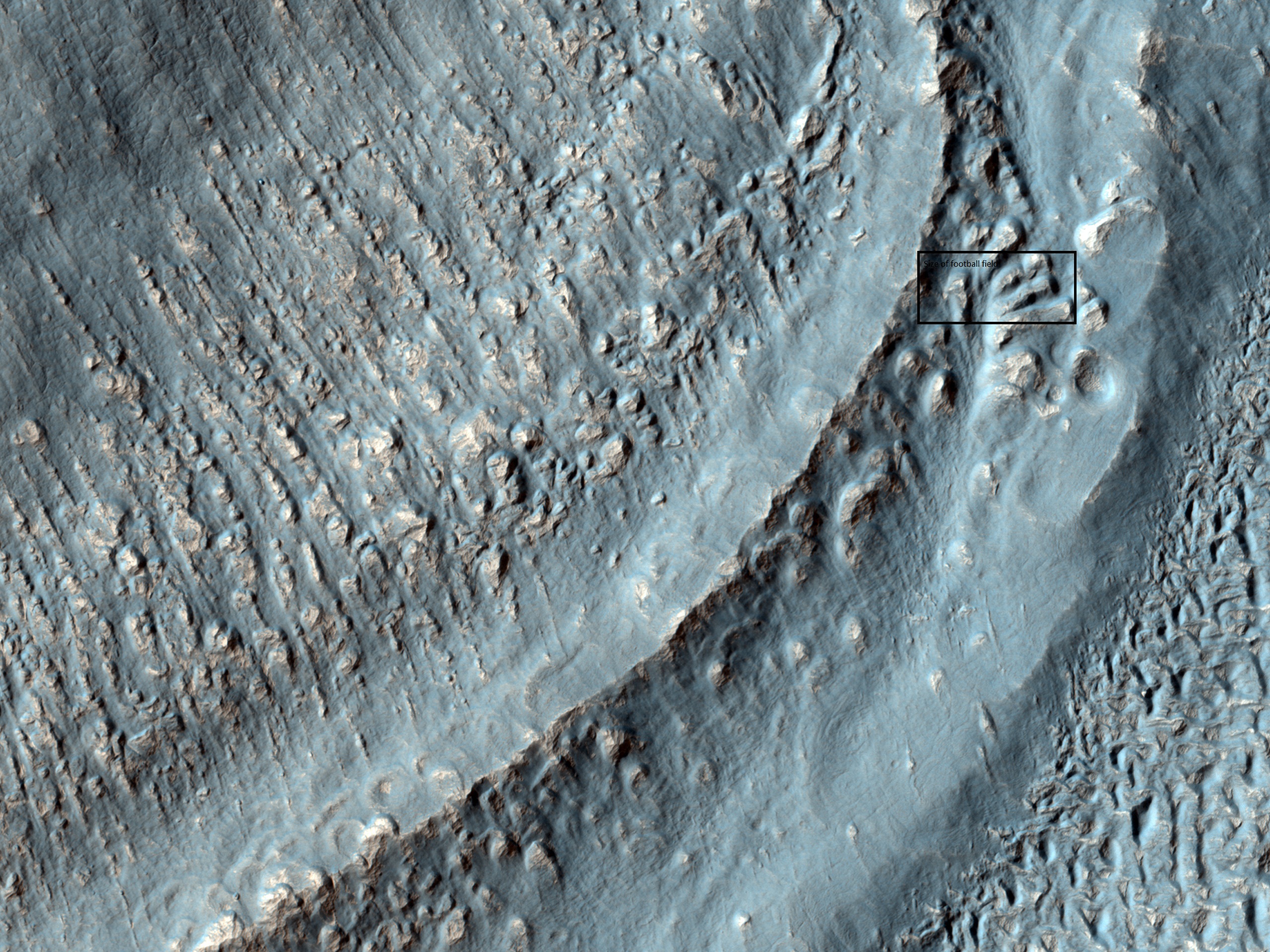
Context for the next image of the end of a flow feature or glacier. Location is Hellas quadrangle. Picture taken with HiRISE under the HiWish program.
-

Close-up of the area in the box in the previous image. This may be called by some the terminal moraine of a glacier. For scale, the box shows the approximate size of a football field. Image taken with HiRISE under the HiWish program. Location is Hellas quadrangle.
-
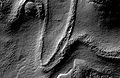
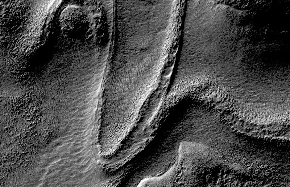
Tongue-Shaped Glacier, as seen by Mars Global Surveyor. Location is Hellas quadrangle.
-

Possible moraine on the end of a past glacier on a mound in Deuteronilus Mensae, as seen by HiRISE, under the HiWish program.
-

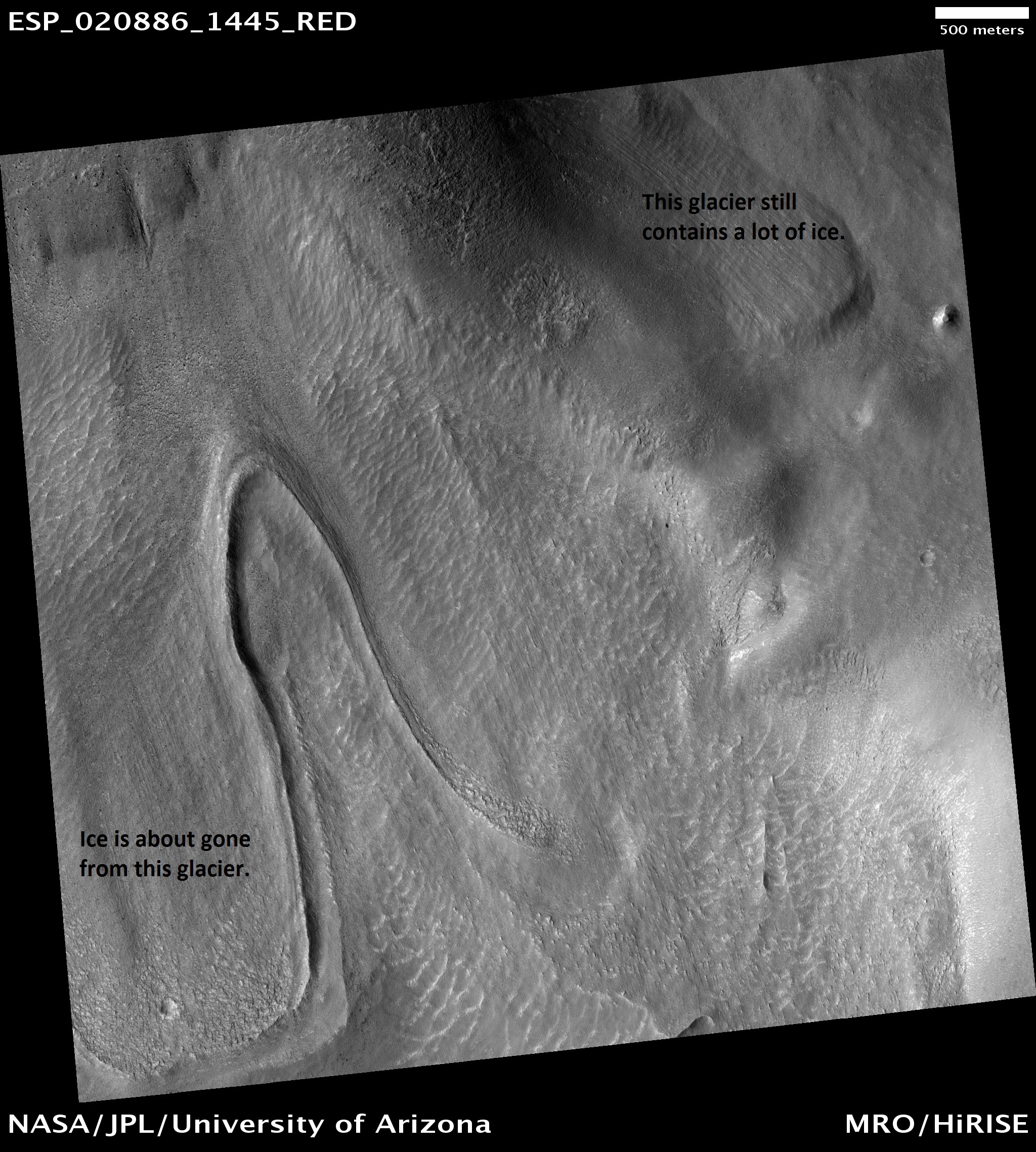
Glaciers, as seen by HiRISE, under HiWish program. Glacier on left is thin because it has lost much of its ice. Glacier on the right on the other hand is thick; it still contains a lot of ice that is under a thin layer of dirt and rock. Location is Hellas quadrangle.
See also
Cited references
- ^ Simpson, D.P. (1979). Cassell's Latin Dictionary (5 ed.). London: Cassell Ltd.. p. 883. ISBN 0-304-52257-0.
- ^ Post, Austin; LaChapelle, Edward R (2000). Glacier ice. Seattle, WA: University of Washington Press. ISBN 0295979100.
- ^ Brown, Molly Elizabeth; Ouyang, Hua; Habib, Shahid; Shrestha, Basanta; Shrestha, Mandira; Panday, Prajjwal; Tzortziou, Maria; Policelli, Frederick; Artan, Guleid; Giriraj, Amarnath; Bajracharya, Sagar R.; Racoviteanu, Adina. "HIMALA: Climate Impacts on Glaciers, Snow, and Hydrology in the Himalayan Region". Mountain Research and Development. International Mountain Society. http://hdl.handle.net/2060/20110015312. Retrieved 16 September 2011.
- ^ "Retreat of alaskan glacier juneau icefield". Nichols.edu. http://www.nichols.edu/departments/glacier/juneau%20icefield.htm. Retrieved 2009-01-05.
- ^ American Meteorological Society, Glossary of Meteorology
- ^ "Sea Level and Climate". USGS FS 002-00. USGS. 2000-01-31. http://pubs.usgs.gov/fs/fs2-00/. Retrieved 2009-01-05.
- ^ * National Snow and Ice Data Center. "Types of Glacier". http://www.nsidc.org/glaciers/questions/types.html.
- ^ Bindschadler, R.A. and T.A. Scambos. Satellite-image-derived velocity field of an Antarctic ice stream. Science, 252(5003), 242-246, 1991
- ^ British Antarctic Survey. "Description of Ice Streams". http://www.antarctica.ac.uk//about_antarctica/geography/ice/streams.php. Retrieved 2009-01-26.
- ^ What causes the blue color that sometimes appears in snow and ice ?
- ^ [Benson, C.S., 1961, "Stratigraphic studies in the snow and firn of the Greenland Ice Sheet", Res. Rep. 70, U.S. Army Snow, Ice and Permafrost Res Establ., Corps of Eng., 120 pp]
- ^ "Glacier change and related hazards in Switzerland". UNEP. http://www.grid.unep.ch/activities/global_change/switzerland.php. Retrieved 2009-01-05.
- ^ http://folk.uio.no/kaeaeb/publications/grl04_paul.pdf Frank Paul, et al., 2004, Rapid disintegration of Alpine glaciers observed with satellite data, GEOPHYSICAL RESEARCH LETTERS, VOL. 31, L21402, doi:10.1029/2004GL020816, 2004
- ^ Recent Global Glacier Retreat Overview
- ^ Greve, R.; Blatter, H. (2009). Dynamics of Ice Sheets and Glaciers. Springer. doi:10.1007/978-3-642-03415-2. ISBN 978-3-642-03414-5.
- ^ W.S.B. Paterson, Physics of ice
- ^ Hughes, T. West Antarctic ice streams. Reviews of Geophysics and Space Physics, 15(1), 1-46, 1977
- ^ "Moulin 'Blanc': NASA Expedition Probes Deep Within a Greenland Glacier". NASA. 2006-12-11. http://www.nasa.gov/vision/earth/lookingatearth/moulin-20061211.html. Retrieved 2009-01-05.
- ^ T. Strozzi et al.: The Evolution of a Glacier Surge Observed with the ERS Satellites (pdf, 1.3 Mb)
- ^ The Brúarjökull Project: Sedimentary environments of a surging glacier. The Brúarjökull Project research idea.
- ^ Meier & Post (1969)
- ^ a b http://people.deas.harvard.edu/~vtsai/files/EkstromNettlesTsai_Science2006.pdf Ekström, G., M. Nettles, and V. C. Tsai (2006)"Seasonality and Increasing Frequency of Greenland Glacial Earthquakes",Science, 311, 5768, 1756-1758, doi:10.1126/science.1122112
- ^ a b http://people.deas.harvard.edu/~vtsai/files/TsaiEkstrom_JGR2007.pdf Tsai, V. C. and G. Ekström (2007). "Analysis of Glacial Earthquakes", J. Geophys. Res., 112, F03S22, doi:10.1029/2006JF000596
- ^ "The Antarctic Sun: Earthshaking Discovery". http://antarcticsun.usap.gov/science/contentHandler.cfm?id=1476.
- ^ Easterbrook, D.J. (1999). Surface Processes and Landforms (2 ed.). New Jersey: Prentice-Hall, Inc.. p. 546. ISBN 0-13-860958-6.
- ^ Glossary of Glacier Terminology
- ^ C.D. Ollier: Australian Landforms and their History, National Mapping Fab, Geoscience Australia
- ^ KINCAID, JONI L.; KLEIN, ANDREW G. (2004). "Retreat of the Irian Jaya Glaciers from 2000 to 2002 as Measured from IKONOS Satellite Images". Portland, Maine, USA. pp. 147–157. http://www.easternsnow.org/proceedings/2004/kincaid_and_klein.pdf. Retrieved 2009-01-05.
- ^ Hawaiian Glaciers Reveal Clues to Global Climate Change
- ^ French Colonies - Crozet Archipelago
- ^ Collins, Henry Hill; Europe and the USSR; p. 263. ISBN 1256350003
- ^ Yukon Beringia Interpretive Center
- ^ Earth History 2001 (page 15)
- ^ "On the Zoogeography of the Holarctic Region"
- ^ "Kettle geology". Britannica Online. http://www.britannica.com/EBchecked/topic/315739/kettle. Retrieved 2009-03-12.
- ^ Kargel, J.S. et al.:Martian Polar Ice Sheets and Mid-Latitude Debris-Rich Glaciers, and Terrestrial Analogs, Third International Conference on Mars Polar Science and Exploration, Alberta, Canada, October 13-17, 2003 (pdf 970 Kb)
- ^ Fretted Terrain: Lineated Valley Fill, Mars Global Surveyor Mars Orbiter Camera, Malin Space Science Systems/NASA
- ^ Martian glaciers: did they originate from the atmosphere?, ESA Mars Express, 20 January 2006
- ^ Head, J. et al. 2005. Tropical to mid-latitude snow and ice accumulation, flow and glaciation on Mars. Nature: 434. 346-350
- ^ http://www.marstoday.com/news/viewpr.html?pid=18050
- ^ http://news.brown.edu/pressreleases/2008/04/martian-glaciers
- ^ Plaut, J. et al. 2008. Radar Evidence for Ice in Lobate Debris Aprons in the Mid-Northern Latitudes of Mars. Lunar and Planetary Science XXXIX. 2290.pdf
- ^ Holt, J. et al. 2008. Radar Sounding Evidence for Ice within Lobate Debris Aprons near Hellas Basin, Mid-Southern Latitudes of Mars. Lunar and Planetary Science XXXIX. 2441.pdf
Uncited references
- This article draws heavily on the corresponding article in the Spanish-language Wikipedia, which was accessed in the version of 24 July 2005.
- Hambrey, Michael; Alean, Jürg (2004). Glaciers (2nd ed.). Cambridge University Press. ISBN 0-521-82808-2. OCLC 54371738. An excellent less-technical treatment of all aspects, with superb photographs and firsthand accounts of glaciologists' experiences. All images of this book can be found online (see Weblinks: Glaciers-online)
- Benn, Douglas I.; Evans, David J. A. (1999). Glaciers and Glaciation. Arnold. ISBN 0470236515. OCLC 38329570.
- Bennett, M. R.; Glasser, N. F. (1996). Glacial Geology: Ice Sheets and Landforms. John Wiley & Sons. ISBN 0471963445. OCLC 37536152 33359888 37536152.
- Hambrey, Michael (1994). Glacial Environments. University of British Columbia Press, UCL Press. ISBN 0774805102. OCLC 30512475. An undergraduate-level textbook.
- Knight, Peter G (1999). Glaciers. Cheltenham: Nelson Thornes. ISBN 0-7487-4000-7. OCLC 63064183 77294832 42656957 63064183 77294832. A textbook for undergraduates avoiding mathematical complexities
- Walley, Robert (1992). Introduction to Physical Geography. Wm. C. Brown Publishers. A textbook devoted to explaining the geography of our planet.
- W. S. B. Paterson (1994). Physics of Glaciers (3rd ed.). Pergamon Press. ISBN 0080139728. OCLC 26188. A comprehensive reference on the physical principles underlying formation and behavior.
External links
- Glaciers of the Pyrenees
- NOW on PBS "On Thin Ice"
- Photo project tracks changes in Himalayan glaciers since 1921
- Short radio episode California Glaciers from The Mountains of California by John Muir, 1894. California Legacy Project.
Glaciers Types of glaciers - Cirque glacier
- Ice cap
- Ice field
- Ice sheet
- Ice shelf
- Ice stream
- Outlet glaciers
- Rock glaciers
- Valley glaciers
- Ledoyom (Ice body)
Anatomy Processes Measurements Glaciovolcanic relations Glacial landforms Erosional- Arête
- Cirque
- Crag and tail
- Fjord
- Glacial horn
- Glacial striae
- Hanging valley
- Ribbon lake
- Roche moutonnée
- Tunnel valley
- U-valley
Depositional- Drumlin
- Drumlin field
- Erratic block
- Moraine
- Pulju moraine
- Rogen moraine
- Terminal moraine
- Till plain
- Veiki moraine
Glacifluvial- Esker
- Kame
- Kame delta
- Kettle hole
- Outwash fan
- Sandur
- Giant current ripples
- Diluvium
- Glaciology
- Category:Glaciers
Categories:- Glaciers
- Bodies of ice
- Montane ecology
- Glacial landforms


Wikimedia Foundation. 2010.