- Apatin
-
Apatin
Апатин— Municipality and Town — A street in Apatin

Coat of armsLocation of the municipality of Apatin within Serbia
Coordinates: 45°40′N 18°59′E / 45.667°N 18.983°E Country Serbia District West Bačka Settlements 5 Government – Mayor Živorad Smiljanić Area[1] – Municipality 333 km2 (128.6 sq mi) Population (2011 census)[2] – Town 19,320 – Municipality 32,813 Time zone CET (UTC+1) – Summer (DST) CEST (UTC+2) Postal code 25260 Area code +381 25 Car plates SO Website www.soapatin.org Apatin (Serbian Cyrillic: Апатин) is a town and municipality in the Vojvodina administrative region of Serbia, located in the West Bačka District, at 45°40′N 18°59′E / 45.667°N 18.983°E. The town of Apatin is the administrative, economic, cultural, educational and tourist centre of the municipality of Apatin (333 km²). The population of the town is 19,289, while the municipality has 32,793 inhabitants.
Contents
Name
In Serbian, the town is known as Apatin (Апатин), while the same name is also used in German, Romanian, Croatian (Šokac), and Hungarian. The name Apatin is derived from the old form Opaty, by which the town was first mentioned in the 11th century during the administration of the Hungarian Kingdom.[3]
Geography
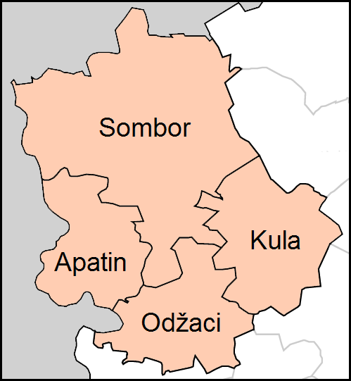
The Municipality of Apatin is located on the left bank of the Danube river (natural border with Croatia), between the Municipality of Sombor (in the north) and Municipality of Odžaci (in the southeast).
History
Apatin is situated in the north-western part of the spacious plain in Bačka, on the left side of the Danube. It is considered one of Vojvodina's pristine gems.
The favourable geographic position, proximity to the Danube, and natural wealth of this area (fruitful ground, woods next to the river, abundance of fish in swampy regions and backwaters, and game in woods) attracted people through all ages and made them settle here. Because of these reasons, even in pre-historic times, cultures such as the Sarmatians, the Celts, the Goths and many others were replacing each other within this region, one by one.
In the 1st century, during the Roman conquest, the settlement was turned into a military trench with fortifications, and played an important role in the defense of the Pannonia province. In the 6th century the Slavs settled[citation needed], and in the 10th century the Hungarians as well, thereby establishing a state, which was populated by both, Hungarians and Slavs.
The first mentioning of Apatin in any written script was in the year 1011, by the Abbey of Kalocsa Bishopric.
During the 14th and 15th centuries, the area became feudalistic, and in exchange for lands, the vassals would need to complete military service to the lord of the property. Many fishermen, hunters, and millers then began to settle down in this area.
In 1417, Apatin is mentioned as a property of Stefan Lazarević, crowned the Despot of Serbia in 1402.[citation needed] In 1526-1527 it belonged to the short-lived state of Emperor Jovan Nenad, and soon after this became part of the Ottoman Empire. During the Ottoman rule Apatin was mainly populated by ethnic Serbs.
In the end of the 17th century it became part of the Habsburg Monarchy. Many of the refugees during the massive migration of Serbs led by Arsenije Čarnojević in 1690, came to Apatin, Sombor and Prigrevica, thus the Serb population in this area increased. A new wave of colonisation occurred in 1748 when many German colonists settled in Apatin, pushing out the Serbs mostly by force, who then evacuated towards Stapar.
 The Orthodox Christian Temple.
The colonists came from many different regions. The gathering centre was in Ulm, Germany and from that point they were transported by the Danube to Apatin, which became the main base of the German expansion in Vojvodina. The church was built near the port and the city square was also built at this time. The real estate value of buildings, such as schools, fishermen’s station, hand craft’s workshops, began to rise.
The Chamber of Court decided to put forth economic objectives to better the economy, and in 1756 the brewery and distillery were built. In 1764 a large textiles factory was built. In 1760 Apatin was officially proclaimed a town and a main trade centre with a special status.
At the end of the 18th century, a catastrophic flood destroyed the old town square, and ruined half of the settlement. The new square was built north-westward from the brewery. The town as seen today, began to take shape. During the 18th and in the early part of 19th century, Apatin had prospered economically, mostly because of developed trade, handcraft and shipbuilding.
In 1848-1849 Apatin was part of the Serbian Voivodship, a Serb autonomous region within Austrian Empire, and between 1849 and 1860 it was part of the Voivodship of Serbia and Tamiš Banat, a separate Austrian province. In 1860 it was included into Habsburg Kingdom of Hungary, which became one of two autonomous parts of the Monarchy after 1867.
 The Assumption of Blessed Virgin Mary Catholic Church in the centre of the town.
In the year of 1869 numerous banks and saving-banks were established, and that opened the door to industrial development. A great number of brickyards produced brick and tile, which were used to construct many buildings in Vienna and almost all in Pest. In 1912 Apatin was connected to Sombor and Sonta by the railroad, and the following year, a shipyard was founded. Today, the shipyard has been modernized as it the only shipyard on the whole Danube which has a special lift for quickly drawing boats out onto the docks.
In 1918, as part of Banat, Bačka and Baranja, Apatin became part of the Kingdom of Serbia, which later together with the Kingdom of Montenegro and the State of Slovenes, Croats and Serbs formed the Kingdom of Serbs, Croats and Slovenes (renamed to Yugoslavia in 1929). Between 1929 and 1941, Apatin was part of the Danube Banovina, one of the provinces of the Kingdom of Yugoslavia.
When Axis Powers invaded and partitioned Yugoslavia in 1941, Apatin was placed under Hungarian administration. During the Battle of Batina, the front was stretched all the way to Apatin and Bogojevo, and these places became military bases overnight. Yugoslav Partisans entered Apatin on October 24, 1944, and since then Apatin was part of the new Socialist Yugoslavia, within the People's Republic of Serbia and the Autonomous Province of Vojvodina.
The antifascist council for deliberation of Yugoslavia (AVNOJ) declared its mainly German population as public enemies. The death toll among the German population of Apatin amounts to 2,074 people known by name. This figure includes the victims of deportation to the USSR.[4]
Between 1992 and 2003, Apatin was part of the Federal Republic of Yugoslavia, between 2003 and 2006 part of the State Union of Serbia and Montenegro, and since 2006 it is part of an independent Serbia.
Inhabited places
 Map of Apatin municipality
Apatin municipality includes the city of Apatin and the following villages:
Demographics (2002 census)
Ethnic groups in the municipality
As many as 24 ethnic groups live in the Apatin municipality, including:
- Serbs = 20,216 (61.61%)
- Hungarians = 3,785 (11.53%)
- Croats = 3,766 (11.47%)
- Romanians = 1,191 (3.62%)
- Yugoslavs = 727 (2.21%)
- Roma = 524 (1.59%)
- Others (including Montenegrins, Macedonians, Muslims, Albanians, Germans, Slovaks, etc.).
Settlements by ethnic majority
Settlements with a Serb ethnic majority are Apatin and Prigrevica. The settlement with a Croat/Šokac ethnic majority is Sonta. Settlements with Hungarian ethnic majority are Kupusina and Svilojevo.
Ethnic groups in the town
- Serbs = 13,990 (72.41%)
- Romanians = 967 (5.01%)
- Hungarians = 848 (4.39%)
- Croats = 658 (3.41%)
- Yugoslavs = 612 (3.17%)
- Roma = 369 (1.91%)
- Germans = 142 (0.74%)
- Montenegrins = 100 (0.52%)
- Others.
Spa
Near the city of Apatin lies the Junaković spa. It is a modern and well-equipped rehabilitation and recreation centre with sports fields, outdoor pools, indoor therapy, and saunas.
Buildings
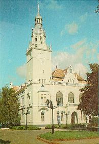
Major buildings in Apatin include the Catholic church of The Assumption of Mary (built in the 18th century), the new Orthodox Christian cathedral, the Apatin city hall, and the Speiser mausoleum.
Economy
Companies
The largest companies in Apatin today are the Apatinska pivara AD (brewery, built in 1756), Rapid (silicate bricks factory), Jedinstvo (agricultural company) and Apatin Shipyard (formerly known as "Boris Kidrič").
Free port Apatin
The Free port Apatin is a free customs zone, cargo-transportation center and port with wharf, which will form an economic unit known under the name "Slobodna zona Apatin" (and will cover 160 hectares of ground next to river Danube). It will also represent one of the potentially largest economical undertakings in the region.
Tourist attraction
Apatin has popular tourist location, and because of its proximity to the Danube river and the forests, it is gathering place for fishermen and hunters. There is also an annual gathering called "Apatinske ribarske večeri" (Apatin Fishermen Nights), which has taken place for the last forty some years. "Ribarske večeri" usually starts on July 1, and lasts five or seven days.
Sport
Apatin has a rich history in sports. Željko Rebrača is by far the most famous athlete from this area, but in the past, Apatin has had athletes represent Yugoslavia (and now Serbia) on the international stage. Today, some of the well known professional sports clubs are:
- FK Mladost - member of the Serbia First League Soccer Association
- RK Apatin - member of the Serbia Second League Handball Association
Famous citizens
- Željko Rebrača (born in 1972), a professional basketball player, and ethnic Serb, playing in the NBA with the L.A. Clippers. He was born in 1972 in the village of Prigrevica near Apatin.
- Pavle Marčetić (born in 1957), a writer and ethnic Serbian, born in Apatin.
- Paul Abraham (1892–1960), a Jewish composer, born in Apatin.
- Gyula Pártos (1845–1916), an architect and ethnic Hungarian, born in Apatin.
- Ervin Sinkó (1898–1967), a writer and ethnic Hungarian, born in Apatin.
- Josef Sayer (born 1941), German Roman Catholic priest, theologian and development aid official
- Jovan Lakatoš (born in 1944), ornitologist of Hungarian origin, born in Apatin.
- Mirko Djuric (born in 1960), a famous classical guitarist.
- Nenad Medić (born 1983), poker player
Gallery
-

Brewery Apatinska Pivara AD
-

Panoramic view of the Spa Junaković
-

Interior of the Spa Junaković
-

Outdoor Pools of the Spa Junaković
-

Apatin's fishermen nights (main event pictured, fish soup contest)
-

Apatin Town Hall
Sources
- ^ "Municipalities of Serbia, 2006". Statistical Office of Serbia. http://webrzs.stat.gov.rs/axd/en/Zip/OG2006webE.zip. Retrieved 2010-11-28.
- ^ "2011 Census of Population, Households and Dwellings in the Republic of Serbia – FIRST RESULTS". Bulletin (Statistical Office of the Republic of Serbia) 540. 2011. ISSN 0354-3641. http://media.popis2011.stat.rs/2011/prvi_rezultati.pdf. Retrieved 2011-11-21.
- ^ DATANET.RS Galerija Meander/Gallery Meander
- ^ Arbeitskreis Dokumentation: Verbrechen an den Deutschen in Jugoslawien 1944-1948, Die Stationen eines Völkermordes, 2000, Munich
External links
Cities, towns and villages in the West Bačka District Sombor Aleksa Šantić · Bački Breg · Bački Monoštor · Bezdan · Gakovo · Doroslovo · Kljajićevo · Kolut · Rastina · Riđica · Svetozar Miletić · Stanišić · Stapar · Telečka · Čonoplja
Apatin Kula Odžaci bold are municipalitiesCategories:- Places in Bačka
- Populated places in Vojvodina
- Municipalities of Vojvodina
- Danube Swabian communities
- West Bačka District
- Apatin
- Rapids of the United States


Wikimedia Foundation. 2010.