- Oregon Route 569
-
Oregon Route 569
Beltline Highway or Randy Papé Beltline 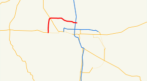
Route information Maintained by ODOT Length: 9.90 mi[1] (15.93 km) Existed: 2007 – present Major junctions West end:  OR 126 in Eugene
East end: Gateway Street in Springfield Highway system Oregon highways
Routes • Highways←  OR 551
US 730  →
→Oregon Route 569 is an Oregon state highway serving as an outer quarter-loop in Eugene and Springfield. OR 569 comprises part of the Beltline Highway No. 69 (see Oregon highways and routes). It is 9.90 miles (15.93 km) long and runs east–west. OR 569 is not a complete beltway, though it was originally proposed as such before freeway revolts resulted in the original plan being scrapped.[citation needed]
In March, 2010, the Oregon Transportation Commission voted to rename the highway from Beltline to Randy Papé Beltway.[2] This name change met much opposition. (See History below.) By April, it was finalized as the Randy Papé Beltline.[3]
Contents
Route description
 Beltline Highway, looking east, from the Gilham Road overpass
OR 569 begins at a T-intersection with OR 126, on the western edge of Eugene. At first, as it heads north and east, it is an expressway, with one at-grade signalized intersection. Soon it becomes a two lane freeway in each direction, as it crosses the northern edge of incorporated Eugene. From the highway, one sees mostly suburban housing and strip malls. At the eastern end, there is an interchange with I-5. Beltline becomes a local road at Gateway Street. The roadway continues, eventually reaching OR 528 in Springfield.
One other section of the initial proposal was built. This section is the stretch of 30th Avenue between the Amazon Park neighborhood and Lane Community College--a four-lane expressway which includes two interchanges. This route does not connect directly to the existing stretch of Belt Line Road.
Several enhancements to the Beltline Road have been proposed. The West Eugene Parkway, had it been built, would have intersected Beltline Road at a new interchange. Plans are underway to upgrade the interchange with the Delta Highway.[4] The I-5 interchange was upgraded in 2008.[5] The latter interchange was a full cloverleaf design, and was considered to be both obsolete and dangerous. To upgrade the interchange, a flyover bridge was built, eliminating the northeastern loop ramp and the weaving movements on northbound Interstate 5 and westbound Beltline Road. Construction is underway to redesign the nearby intersection with Gateway Boulevard.[6]
History
The Beltline Highway was constructed by Lane County in the 1960s and transferred to state control in 1978 as Highway 69.[7][8] The highway was assigned the Route 69 designation effective September 19, 2002.[9] However, due to the sexual connotation of the number 69, sign theft would have been an issue, and the Oregon Department of Transportation wanted to sign the route to make navigation easier during the 2008 U.S. Olympic Trials,[10] so ODOT requested that the Oregon Transportation Commission change the number to 14.[11] At their January 25, 2007 meeting, the OTC decided to instead call the highway Route 569,[12][13] which kept with the pattern used in other cases where the highway number could not be used (usually because there was already a route with that number). Signs for Route 569 were posted by August 2007.[14]
Controversy with renaming Beltline
In early 2010, Oregon governor Ted Kulongoski requested that Beltline Highway be renamed for local businessman and civic leader Randy Papé. On March 11, the Oregon Transportation Commission approved renaming it to the Randy Papé Beltway.[2] This caused a huge uproar against the decision: there was little chance for any citizen feedback, and if the plan went through around $250,000 would have been spent on sign changes.[15][16][17] On April 13, 2010, the Lane County Board of Commissioners voted unanimously to request a suspension of any plans to rename the highway.[18] The Oregon Transportation Commission, however, barely budged, and on April 21 settled on the name Randy Pape Beltline.[3] Initially, to save money, only 2 signs, one at each end of the route, will be changed.[19] Other signs will be replaced as they wear out.[19] Opponents argued that while this proposal looks like a great deal on the surface, emails obtained from ODOT through public records request show that the renaming of the highway adds extra letters to the signs which translates into larger signs which may also require larger supports. ODOT estimated that instead of the original cost of $250,000 to replace the 53 signs that the new estimate could reach over $500,000. Opponents sought to reverse the name change and had a bit more than 1000 signatures by placing a measure on the November 2010 ballot that would require state-wide voter approval to rename state-owned property but fell more than 80,000 signatures short, having had only a few days to collect them. There may be another attempt in 2012.[20]
Exit list
The entire route is in Lane County.
Location Mile[1] # Destinations Notes Eugene 3.10 OR 126 (West 11th Avenue)At-grade 4.24 Roosevelt Boulevard At-grade 5.62 5 Barger Drive 6.58 6  OR 99 – Eugene Airport, Junction City
6.83 7A Prairie Road Westbound exit and eastbound entrance 7.09 7 Northwest Expressway 8.47 8 River Road - Santa Clara 9.56 River Avenue, Division Avenue No westbound entrance 10.05 Delta Highway, Ayres Road - Valley River Center, Downtown Eugene 11.66 Coburg Road 12.77-12.78  I-5 – Roseburg, Portland
Springfield 13.00 Gateway Street At-grade References
- ^ a b Oregon Department of Transportation, Straightline Chart: Beltline Highway No. 069, November 2005
- ^ a b "Commission OKs renaming Belt Line after Papé". The Register-Guard. March 12, 2010. http://www.registerguard.com/csp/cms/sites/web/news/cityregion/24553309-41/papé-belt-eugene-randy-signs.csp.
- ^ a b Baker, Mark (April 21, 2010). "It's Randy Pape Beltine". The Register-Guard. http://dailyme.com/story/2010042100005185/randy-pape-beltline.html.
- ^ http://www.mckweb.com/DeltaRidge/TImaps
- ^ Northwest Region- Region 2 I-5/Beltline Interchange
- ^ City of Springfield, Oregon 97477
- ^ Oregon @ WestCoastRoads.com - Belt Line Highway (Eugene)
- ^ http://www.oregon.gov/ODOT/TD/TP/docs/orhwyplan/analysis/13analysis.pdf
- ^ Oregon Department of Transportation, Descriptions of US and OR Routes, May 2005
- ^ Bob Welch, The Register-Guard, Q&A, September 20, 2007
- ^ Oregon Transportation Commission, Agenda: January 24 and 25, 2007, Salem, p. 3
- ^ Oregon Transportation Commission, Minutes of the Regular Monthly Meeting: January 24 and 25, 2007, Salem, p. 4
- ^ Oregon Department of Transportation, Descriptions of US and OR Routes, July 2007
- ^ Carla Castano, KVAL-TV, Bye bye Beltline... Hello Route 569, August 28, 2007
- ^ McKee, Chris (March 12, 2010). "Concerns raised over cost of "Beltline Highway" renaming". KMTR. http://www.kmtr.com/news/local/story/Concerns-raised-over-cost-of-Beltline-Highway/wKrTmK1hiUCdam6u4EwmMg.cspx.
- ^ Hintze, Heather (March 15, 2010). "Beltline Name Change Sparks Online Debate". KEZI. http://kezi.com/page/166206.
- ^ Welch, Bob (March 16, 2010). "Let’s honor Randy Papé a better way". The Register-Guard. http://www.registerguard.com/csp/cms/sites/web/sports/columnists/24568028-41/pap%C3%A9-honor-transportation-welch-bridge.csp.
- ^ Kalinoski, Stacia (April 13, 2010). "Lane County Board of Commissioners Opposed to Renaming the Beltline". KEZI.
- ^ a b "New Randy Pape Beltline Signs On The Way". KEZI.com. April 28, 2010. http://kezi.com/news/local/171856.
- ^ http://kezi.com/news/local/180155
Categories:- State routes in Oregon
- Transportation in Eugene, Oregon
- Springfield, Oregon


Wikimedia Foundation. 2010.