- Albreda
Infobox Settlement
official_name =PAGENAME
other_name =
native_name =
nickname =
settlement_type =
motto =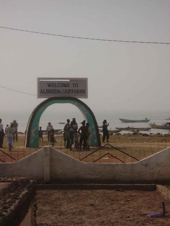
imagesize = 240px
image_caption = The Albreda-Jufureh archway
flag_size =
image_
seal_size =
image_shield =
shield_size =
image_blank_emblem =
blank_emblem_type =
blank_emblem_size =
mapsize =
map_caption =
mapsize1 =
map_caption1 =
image_dot_
dot_mapsize =
dot_map_caption =
dot_x = |dot_y =
pushpin_
pushpin_label_position =bottom
pushpin_mapsize =300
pushpin_map_caption =Location in The Gambia
subdivision_type = Country
subdivision_name =The Gambia
subdivision_type1 = Division
subdivision_name1 =North Bank Division
subdivision_type2 = District
subdivision_name2 =
subdivision_type3 =
subdivision_name3 =
subdivision_type4 =
subdivision_name4 =
government_footnotes =
government_type =
leader_title =
leader_name =
leader_title1 =
leader_name1 =
leader_title2 =
leader_name2 =
leader_title3 =
leader_name3 =
leader_title4 =
leader_name4 =
established_title =
established_date =
established_title2 =
established_date2 =
established_title3 =
established_date3 =
area_magnitude =
unit_pref =Imperial
area_footnotes =
area_total_km2 =
area_land_km2 =
area_water_km2 =
area_total_sq_mi =
area_land_sq_mi =
area_water_sq_mi =
area_water_percent =
area_urban_km2 =
area_urban_sq_mi =
area_metro_km2 =
area_metro_sq_mi =
area_blank1_title =
area_blank1_km2 =
area_blank1_sq_mi =
population_as_of =
population_footnotes =
population_note =
population_total = 1776
population_density_km2 =
population_density_sq_mi =
population_metro =
population_density_metro_km2 =
population_density_metro_sq_mi =
population_urban =
population_density_urban_km2 =
population_density_urban_sq_mi =
population_blank1_title =Ethnicities
population_blank1 =
population_blank2_title =Religions
population_blank2 =
population_density_blank1_km2 =
population_density_blank1_sq_mi =
timezone =
utc_offset =
timezone_DST =
utc_offset_DST =
latd=13|latm=20|lats= 04|latNS=N
longd=16|longm=23|longs=12|longEW=W
elevation_footnotes =
elevation_m =
elevation_ft =
postal_code_type =
postal_code =
area_code =
blank_name =
blank_info =
blank1_name =
blank1_info =
website =
footnotes =Albreda is an historic settlement in
The Gambia on the north bank of theGambia River , variously described as a 'trading post' or a 'slave fort'. It is located nearJufureh in theNorth Bank Division and an arch stands on the beach connecting the two places. As of 2008, it has an estimated population of 1,776. [ [http://world-gazetteer.com/wg.php?x=&men=gcis&lng=en&des=wg&srt=npan&col=abcdefghinoq&msz=1500&geo=-88 World Gazetteer] , Retrieved onAugust 20 2008 ]History
Musa Gaye, a
Wolof marabout , founded it sometime between1520 and1681 . Wolof traders called the island Draga, while theMandinka s called it Albadar. [Unesco National Records Service http://64.233.183.104/search?q=cache:sAQ9cI5TIOsJ:portal.unesco.org/ci/en/files/9647/10522977910CDROM_slave_trade_GAMBIA.doc/CDROM_slave_trade_GAMBIA.doc+Musa+Gaye,+albreda&hl=en&ct=clnk&cd=1&client=safari|]In 1681, a local ruler,
Niumi Mansa , gave the land to the French because his people depended on trade with Europeans. The Frenchexclave was never very large (never more than one factory) but its location was inconvenient for the British, who otherwise had amonopoly on trade on theGambia River . The British also possessed Fort Gambia on James Island, which was less than two miles away on the opposite bank, and which fulfilled a similar function. There was constant tension and occasional skirmishes between the two powers, with Fort Gambia changing hands between them several times.Albreda was transferred from French control to the British empire in
1857 . Today it contains a slavemuseum .References
External links
* [http://www.antislavery.org/breakingthesilence/slave_routes/slave_routes_gambia.shtml Brief history and description]
* [http://www.gambia.co.uk/docs/about_the_gambia/points_of_interest/albreda.aspx More details with a map]

Wikimedia Foundation. 2010.