- U.S. Route 40 in New Jersey
-
This article is about the section of highway in New Jersey. For the entire length of highway, see U.S. Route 40.
U.S. Route 40
Harding Highway
Black Horse Pike
US 40 highlighted in redRoute information Maintained by NJDOT, DRBA, NJTA, and Atlantic County Length: 64.32 mi[1] (103.51 km) Major junctions West end: 
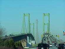
 I-295 / US 40 on Delaware Memorial Bridge at Delaware state line in Pennsville Township
 I-295 / US 130 / Route 49 in Pennsville Township
 NJ Turnpike in Carneys Point Township
 Route 55 in Franklin Township
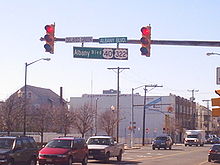
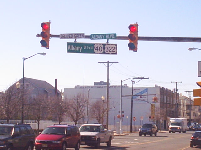
 US 322 in Hamilton Township
 G.S. Pkwy. in Egg Harbor Township
 US 9 in Pleasantville
East end: Atlantic Avenue/Pacific Avenue in Atlantic City Highway system United States Numbered Highways
List • Bannered • Divided • ReplacedNew Jersey State Highway Routes
Interstate and US←  Route 39
Route 40  →
→U.S. Route 40 is a U.S. highway running from Park City, Utah east to Atlantic City, New Jersey. The easternmost segment of the route runs 64.32 miles (103.51 km) through the southern part of New Jersey between the Delaware Memorial Bridge over the Delaware River in Pennsville Township, Salem County, where it continues into Delaware along with Interstate 295 (I-295), east to Atlantic Avenue and Pacific Avenue in Atlantic City, Atlantic County. The route passes through Salem, Gloucester, and Atlantic counties as well as the towns Woodstown, Elmer, Newfield, and Buena. The route encounters a mix of rural, suburban, and urban environs throughout its journey across South Jersey.
In 1923, pre-1927 Route 18S was to run from Penns Grove to Atlantic City along much of present-day US 40 in New Jersey. US 40 was signed along Route 18S in 1926, running from a ferry in Penns Grove that crossed the Delaware River to Wilmington, Delaware. In 1927, Route 18S was renumbered to Route 48. The portion of US 40 in Atlantic City was legislated as Route 55 in 1938, around the same time the route was moved to a ferry across the Delaware River between Pennsville and New Castle, Delaware. After the Delaware Memorial Bridge and the New Jersey Turnpike were both completed in 1951, US 40 was moved to its current alignment in the area. In 1953, the Route 48 and Route 55 designations along US 40 were removed. A toll freeway was once planned along the US 40 corridor in the 1980s to alleviate traffic, but it was never built after it was deemed the traffic volume was not high enough for it to be constructed.
Contents
Route description
Salem County
US 40 enters New Jersey along with I-295 from Delaware on the Delaware Memorial Bridge over the Delaware River. The road heads southeast into Pennsville Township, Salem County as a six-lane freeway maintained by the Delaware River and Bay Authority that passes through industrial areas.[2][3] I-295/US 40 interchanges with US 130 and Route 49, where I-295 splits from US 40 by turning northeast on a freeway that soon overlaps CR 551 briefly while US 40 follows the four-lane New Jersey Turnpike and continues east on it for a short distance, entering Carneys Point Township.[3][4] US 40 splits from the New Jersey Turnpike at the last exit before the toll barrier, the same point where Route 140 heads west and CR 540 heads to the east.[1] From this point, US 40 becomes a surface four-lane divided highway maintained by the New Jersey Department of Transportation called Wiley Road that runs a short distance south of the New Jersey Turnpike, containing a wide median.[1][2] It continues into rural areas consisting of woods, farms, and residences, heading farther to the south of the New Jersey Turnpike.[2]
Upon meeting the eastern terminus of Route 48, US 40 turns to the southeast and becomes the Harding Highway, a two-lane undivided road that passes through more agricultural areas. Upon crossing CR 646, the road enters Pilesgrove Township and continues past the Cowtown Rodeo. The route passes through the residential community of Sharptown before coming to an intersection with Route 45. At this point, US 40 turns to the northeast to run concurrent on Route 45 and enters Woodstown, where it becomes West Avenue and passes residences before reaching the downtown area. Here, Route 45 splits from US 40 by heading north on Main Street and US 40 continues to the east as East Avenue, passing more developed areas. The route crosses from Woodstown into Pilesgrove Township again, where it turns east-southeast as Harding Highway and heads back into a mix of fields and woods amid homes.[1][2] About 0.17 mi (0.27 km) after entering Upper Pittsgrove Township, the road crosses CR 581. In the community of Pole Tavern further to the east, US 40 encounters Route 77, CR 604, and CR 635 at the Pole Tavern Circle.[1] Past Pole Tavern, the road passes more farm fields before coming to Elmer, where it becomes Chestnut Street. In Elmer, the route passes homes and makes a turn to the northeast onto Front Street. Upon leaving Elmer, US 40 becomes Harding Highway again and forms the border of Upper Pittsgrove Township to the north and Pittsgrove Township to the south, passing through forested areas among development. The route crosses CR 553 before passing through the community of Porchtown.[1][2]
Gloucester County

After Porchtown, US 40 crosses into Franklin Township in Gloucester County, turning southeast and running through more woods.[1][2] It comes to a cloverleaf interchange with Route 55, where US 40 is briefly a four-lane divided highway.[1] Past Route 55, the route continues past Malaga Lake and comes to the community of Malaga.[2] In Malaga, the route heads into a business district and intersects Route 47, turning to the northeast to run concurrent on a three-lane road with a center left-turn lane through inhabited areas. After passing over a Conrail Shared Assets Operations railroad line, US 40 and Route 47 split. Route 47 heads north and US 40 turns south and continues parallel to the railroad tracks.[1][2] The road makes a turn to the east-southeast, leaving Malaga and returning to areas of farmland and trees.[2] The road briefly runs along the northern border of Newfield before coming to a crossroads with CR 555.[1] After passing near the Vineland-Downstown Airport, US 40 intersects CR 557 and forms a concurrency with that route.[1][2]
Atlantic County
Immediately after CR 557 joins US 40, the road enters Buena, Atlantic County and continues southeast into inhabited areas. After running through the commercial center of town, the road comes to the southern terminus of Route 54 and the eastern end of CR 619 in a business area located on the outskirts.[1][2] At this point, it enters Buena Vista Township, and CR 557 splits form US 40 by heading to the southeast on Buena-Tuckahoe Road.[1] From this point, US 40 enters dense woodland containing homes and businesses as well as occasional farms.[2] The road reaches the residential community of Richland, where it encounters the eastern terminus of CR 540 and CR 622 and crosses a Conrail Shared Assets Operations railroad line. Upon leaving Richland, the route crosses into Hamilton Township, where it runs through Mizpah before heading back into forested areas and a few residential sectors. US 40 intersects the eastern terminus of CR 552, briefly becoming a divided highway before turning east into denser inhabited areas.[1][2] The route meets Route 50 as that route joins US 40 before the road crosses the Great Egg Harbor River.[1] Upon crossing the river, the road enters Mays Landing and turns north into the downtown area.[1][2] Here, it meets CR 559 and US 40 splits from Route 50 by turning east onto that route.[1] The road passes more development before CR 559 splits from the road by heading southeast. US 40 heads east out of Mays Landing, where it continues through woodland and increasing residential development. The road widens into four lanes as it comes to US 322 (Black Horse Pike) near the Hamilton Mall.[1][2] At this point, US 40 forms a concurrency with US 322, which lasts for the remainder of the route.[1]
The two routes continue to the southeast through business areas, meeting CR 575 and a ramp to the Atlantic City Expressway. CR 575 turns east to follow US 40/US 322.[1][2] The road enters Egg Harbor Township, and CR 575 splits from US 40/US 322 by turning to the south.[1] The route passes more wooded residential and commercial areas, as well as the Storybook Land amusement park, before intersecting CR 563. US 40/US 322 forms a concurrency with that route and passes through a business district that includes the Shore Mall. CR 563 splits from the road by continuing southeast and the Black Horse Pike heads east interchange with the Garden State Parkway.[1][2] The only direct ramp present is between the Black Horse Pike westbound and the Garden State Parkway northbound; all other movements are provided by CR 563.[2] Past here, US 40/US 322 continues east past more businesses, crossing CR 651 before entering Pleasantville. In Pleasantville, the road crosses US 9, where the name changes to Verona Avenue. Upon crossing CR 585, the Black Horse Pike continues past residences as an undivided road, crossing back into Egg Harbor Township. The road passes more businesses, closely paralleling the Atlantic City Expressway before entering Atlantic City. Here, the name becomes Albany Avenue and it comes to a pair of ramps that provide access to and from the Black Horse Pike eastbound and the Atlantic City Expressway westbound.[1][2] US 40/US 322 enters marshland, crossing the Great Thorofare onto Great Island before passing over the Beach Thorofare. Past this bridge, the road passes between businesses to the west and the closed Bader Field airport and the abandoned Bernie Robbins Stadium to the east.[2] US 40/US 322 crosses the Inside Thorofare on a drawbridge and continues as a county maintained road to its end at Atlantic Avenue and Pacific Avenue, one block from the boardwalk.[1][2] Through New Jersey, US 40 serves as a main road connecting Atlantic City with points south along Interstate 95, such as Baltimore and Washington, D.C.[5]
History
 Route 55 (1938-1953)
The portion of US 40 that overlaps US 322 follows the Black Horse Pike, a turnpike established in 1855 that was to run from Camden to Atlantic City via Blackwoodtown.[6] In 1923, pre-1927 Route 18S was created along the current alignment of US 40 east of the Route 48 intersection, running from Penns Grove to Atlantic City.[7] When the U.S. Highway System was established in 1926, the alignment of US 40 in New Jersey ran from Penns Grove, where a ferry carried the route across the Delaware River to Wilmington, Delaware, east to Atlantic City along pre-1927 Route 18S.[8][9] In the 1927 New Jersey state highway renumbering that occurred a year later, pre-1927 Route 18S was replaced by Route 48.[10][11] In 1936, US 322 was also signed concurrent with US 40 on the Black Horse Pike.[12] The portion of US 40/US 322 that existed in Atlantic City was legislated as Route 55 in 1938.[13] Also by 1938, US 40 was moved to a ferry that ran across the Delaware River between Pennsville and New Castle, Delaware, following current Route 49, local roads, and CR 551 to travel between the ferry and Route 48.[14] Following the completion of the Delaware Memorial Bridge and the New Jersey Turnpike in 1951, US 40 was moved to the new bridge and routed to follow a small portion of the New Jersey Turnpike and Wiley Road to the current eastern terminus of Route 48.[15] In the 1953 New Jersey state highway renumbering, which eliminated concurrencies between U.S. highways and state routes, Route 48 was removed from the portion of US 40 east of its current eastern terminus and the Route 55 designation was dropped entirely.[16][17]
In the 1980s, Congressman William J. Hughes proposed a freeway along the US 40 corridor in order to alleviate increased traffic along that route following the legalization of gambling in Atlantic City. This freeway, which was to be maintained by the New Jersey Expressway Authority, was to run from the Delaware Memorial Bridge east to Atlantic City.[18] The NJDOT determined that the traffic volume on US 40 did not justify the construction of a freeway along the corridor.[19] The Cardiff Circle along US 40/US 322 at CR 563 and CR 608 in Egg Harbor Township was eliminated in a $3.7 million project completed in 2002.[20]
Major intersections
County Location Mile[1] Destinations Notes Delaware Memorial Bridge over the Delaware River Salem Pennsville Township 0.95 I-295 north – Camden, TrentonEast end of I-295 overlap, west end of NJTP overlap 1.17 US 130 north / Route 49 south – Penns Grove, Pennsville, SalemI-295 exit 1 Carneys Point Township 1.70 NJ Turnpike north – New YorkEast end of NJTP overlap 1.85 
 Route 140 west / CR 540
5.43  Route 48 west
Pilesgrove Township 10.02  Route 45 south (Salem-Woodstown Road)
West end of NJ 45 overlap Woodstown 10.67 Route 45 north (North Main Street)East end of NJ 45 overlap Upper Pittsgrove Township 14.57  CR 581 (Commissioners Pike)
16.52  Route 77
Pole Tavern Circle 21.82  CR 553 (Buck Road)
Gloucester Franklin Township 25.54 Route 55 – Glassboro, Bellmawr, Vineland, Millville, Cape MayNJ 55 exit 39 26.71  Route 47 south (Delsea Drive)
West end of NJ 47 overlap 27.21 Route 47 north (Delsea Drive)East end of NJ 47 overlap 30.25  CR 555 (Main Road)
32.71  CR 557 north (Tuckahoe Road)
West end of CR 557 overlap Atlantic Buena 35.17  Route 54 north (Blue Anchor Road)
Buena Vista Township 35.30 CR 557 south (Buena-Tuckahoe Road)East end of CR 557 overlap 38.23 CR 540 west (Cedar Avenue)Hamilton Township 45.21  CR 552 west (Millville Road)
46.39  Route 50 south (Mill Street)
West end of NJ 50 overlap 47.01  Route 50 north (Cape May Avenue) / CR 559 north (Main Street)
East end of NJ 50 overlap, west end of CR 559 overlap 47.34 CR 559 south (Somers Point Road)East end of CR 559 overlap 51.77 US 322 west (Black Horse Pike)West end of US 322 overlap 51.97 
 CR 575 north (Wrangleboro Road) to AC Exwy.
West end of CR 575 overlap Egg Harbor Township 53.89 CR 575 south (English Creek Avenue)East end of CR 575 overlap 56.98  CR 563 north (Tilton Road)
West end of CR 563 overlap 57.38 CR 563 south (Tilton Road)East end of CR 563 overlap 57.46 G.S. Pkwy. northGSP exit 36 Pleasantville 59.13 US 959.50  CR 585 (Main Street)
Atlantic City 61.99-62.17 AC Exwy. west to G.S. Pkwy. – Camden, PhiladelphiaACE exit 2 62.69 Atlantic City High School Interchange 64.32 Atlantic Avenue/Pacific Avenue Eastern terminus of US 40/US 322 1.000 mi = 1.609 km; 1.000 km = 0.621 mi See also
 U.S. Roads portal
 New Jersey portal
References
- ^ a b c d e f g h i j k l m n o p q r s t u v w x y "US 40 Straight Line Diagram" (PDF). New Jersey Department of Transportation. http://www.state.nj.us/transportation/refdata/sldiag/00000040__-.pdf. Retrieved 2009-10-14.
- ^ a b c d e f g h i j k l m n o p q r s t u Google, Inc. Google Maps – overview of U.S. Route 40 in New Jersey (Map). Cartography by Google, Inc. http://maps.google.com/maps?f=d&source=s_d&saddr=Delaware+Memorial+Bridge&daddr=39.446799,-74.764709+to:39.35,+-74.4535&geocode=FaOZXQIdba1_-yH3Lhb1ZpfbJw%3B%3BFfBuWAIdBO6P-w&hl=en&mra=dpe&mrcr=0&mrsp=1&sz=9&via=1&sll=39.618384,-74.987183&sspn=0.966864,1.766052&ie=UTF8&t=h&z=9. Retrieved 2009-10-21.
- ^ a b "I-295 Straight Line Diagram" (PDF). New Jersey Department of Transportation. http://www.state.nj.us/transportation/refdata/sldiag/00000295__-.pdf. Retrieved 2009-10-21.
- ^ "New Jersey Turnpike Straight Line Diagram" (PDF). New Jersey Department of Transportation. http://www.state.nj.us/transportation/refdata/sldiag/00000700__-.pdf. Retrieved 2009-10-21.
- ^ "Tropicana Casino and Resort - FAQ's". Tropicana Casino and Resort Atlantic City. http://www.tropicana.net/faq/index.htm. Retrieved 2009-10-21.
- ^ "Answer Guy: How did the White Horse and Black Horse Pikes get their names?". The Press of Atlantic City. August 31, 2008.
- ^ Williams, Jimmy and Sharon. "NJ 1920s Route 18-S". 1920s New Jersey Highways. http://www.jimmyandsharonwilliams.com/njroads/1920s/route18s.htm. Retrieved 2009-03-04.
- ^ Bureau of Public Roads (1926). United States System of Highways (Map). http://en.wikipedia.org/wiki/Image:1926us.jpg. Retrieved 2009-04-27.
- ^ Williams, Jimmy and Sharon. "1927 Tydol Trails Map - South". 1920s New Jersey Highways. http://www.jimmyandsharonwilliams.com/njroads/1920s/maps/1927tt2.jpg. Retrieved 2009-03-30.
- ^ State of New Jersey, Laws of 1927, Chapter 319.
- ^ Williams, Jimmy and Sharon. "1927 New Jersey Road Map". 1920s New Jersey Highways. http://www.jimmyandsharonwilliams.com/njroads/1920s/images/1927_routes.gif. Retrieved 2008-10-08.
- ^ "US 322 Straight Line Diagram". Internet Archives WayBack Machine. New Jersey Department of Transportation. 2004. Archived from the original on 2004-07-24. http://web.archive.org/web/20040724135549/http://www.state.nj.us/transportation/refdata/sldiag/00000322__-.pdf. Retrieved 2007-06-14.
- ^ State of New Jersey, Laws of 1938, Chapter 283.
- ^ Nitzman, Alex. "1938 Delaware Road Map". AARoads. http://www.aaroads.com/delaware/road_maps.htm. Retrieved 2009-03-04.
- ^ Nitzman, Alex. "1951 Delaware Road Map". AARoads. http://www.aaroads.com/delaware/road_maps.htm. Retrieved 2009-03-30.
- ^ 1953 renumbering, New Jersey Department of Highways, http://en.wikisource.org/wiki/1953_New_Jersey_state_highway_renumbering, retrieved July 31, 2009
- ^ "New Road Signs Ready in New Jersey". The New York Times. 1952-12-16. http://img123.imageshack.us/img123/6933/19521216newroadsignsreaiu6.jpg. Retrieved 2009-07-20.
- ^ Sardella, Carlos M. (1983-06-26). "Hughes Presses for New Route". The New York Times.
- ^ "Jersey To Review Need for Highway". The New York Times. 1984-11-04.
- ^ "Temporary detour of traffic at the Cardiff Circle to begin Friday evening, May 3". New Jersey Department of Transportation. 2002-05-01. http://www.state.nj.us/transportation/about/press/2002/050102.shtm. Retrieved 2009-10-21.
External links
Road transportation infrastructure of the metro Philadelphia area Interstates U.S. Routes Pennsylvania Routes New Jersey Routes Delaware Routes Named roads/streets Benjamin Franklin Parkway · Broad Street · City Avenue · Front Street · Girard Avenue · Market Street · Roosevelt Boulevard · South Street · Chestnut Street · Walnut Street
Pennsylvania Turnpike · New Jersey Turnpike · Delaware Turnpike · Atlantic City Expressway · Schuylkill Expressway · Delaware Expressway · Blue Route · Vine St Expressway · North South Freeway · Lancaster Avenue · Bethlehem Pike · Baltimore Pike · Black Horse PikeBridges Delaware Memorial Bridge · Commodore Barry Bridge · Walt Whitman Bridge · Ben Franklin Bridge · Betsy Ross Bridge · Tacony–Palmyra Bridge · Burlington–Bristol Bridge · Delaware River – Turnpike Toll Bridge U.S. Route 40Previous state:
DelawareNew Jersey Next state:
TerminusCategories:- U.S. Route 40
- U.S. Highways in New Jersey
- Intracoastal Waterway
- Transportation in Atlantic County, New Jersey
- Transportation in Gloucester County, New Jersey
- Transportation in Salem County, New Jersey


Wikimedia Foundation. 2010.