- Can Tho Bridge
-
Cần Thơ Bridge 
Other name(s) Cầu Cần Thơ Crosses Sông Hậu Giang (Bassac River) Locale Cần Thơ, Vietnam Design Cable-stayed bridge Total length 2,750 metres (9,022 ft), 15,850 metres (52,001 ft) include approach ramps Width 23.1 metres (76 ft) Height 171.3 metres (562 ft) Longest span 550 metres (1,804 ft) Vertical clearance 39 metres (128 ft) Construction begin September 25, 2004 Opened April 24, 2010 Coordinates 10°03′18″N 105°47′39″E / 10.055°N 105.79417°E Cần Thơ Bridge is a cable-stayed bridge over the Hậu (Bassac) River, the largest distributary of the Mekong River, in the city of Cần Thơ in southern Vietnam. The bridge is 2.75 kilometres long (1.68 miles). It has a 6-lane carriageway measuring 23 metres (76 feet) in width, with 4 lanes for traffic and two pedestrian lanes. It has a clearance of 39 metres (128 feet), which allows large ships to pass underneath it.[1] The bridge was inaugurated on April 24, 2010.[2]
The bridge is currently the longest main span cable-stayed bridge in Southeast Asia. The cost of construction is estimated to be 4.842 trillion Vietnamese đồng (approximately 342.6 million U.S. dollars), making it the most expensive bridge in Vietnam.[1]
Contents
Construction
Prime Minister Phan Văn Khải launched construction of the bridge on September 25, 2004, which was scheduled to be completed in late 2008. The collapse of the partially built bridge in 2007 delayed its opening. The can Tho bridge is one among 17 bridges planned to integrate the Mekong Delta into the road network of Vietnam by 2020. The bridge replaced the network of ferries on the National Road 1A linking Vĩnh Long Province on the east shore with Cần Thơ city on the westbank.[1]
The construction of the bridge was supervised by the consultant group Nippon Koei-Chodai and contracted to several Japanese contractors: Taisei Corporation, Kajima Construction and Nippon Steel. Capital for the project was funded by the Japan International Cooperation Agency with official development assistance loan from the Japan Bank of International Cooperation and the Vietnamese government.[1] Cần Thơ Bridge is insured by the Petrolimex Joint Stock Insurance Company and PetroVietnam Insurance Company for 3.2 trillion Vietnamese đồng (200 million U.S. dollars).[3]
The construction of the Cần Thơ Bridge was subdivided into three contracts, with one contractor handling the first approach bridge, the second building the main bridge, and the third constructing the southern approach road into Cần Thơ.[4]
Collapse
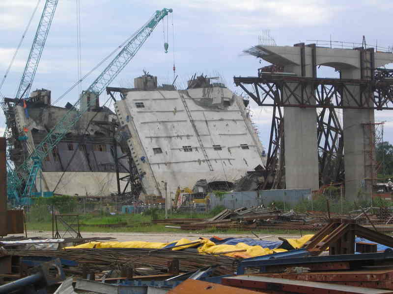
 Pieces of Cần Thơ Bridge remaining after its collapse on October 4, 2007, ten days after the accident.
 Main article: Collapse of Can Tho Bridge
The partially built Cần Thơ Bridge collapsed during construction. The accident occurred at 8 a.m. local time (GMT+7) on the morning of September 26, 2007, when a 90-meter section of an approach ramp, rising more than 30 meters above the ground, collapsed.[5] The collapsed section was above a small island located on the Vinh Long side of the bridge.[6] There were 250 engineers and workers working on and under the span at the time.[7][8] As of September 27, the number of reported casualties varies, with one source saying 52 people died and 140 were injured.[9] While other sources show that the death toll has reached 59,[10] still others report the number of casualties have reached 64.[11] According to Dr. Trần Chủng, head of the national construction QA/QC authority under the Ministry of Construction, this is the most catastrophic disaster in the history of Vietnam’s construction industry.[12]
Rescue efforts
Immediately following the accident, many workers at the site joined the rescue forces to take the injured out of the debris.[13] Local people, students, and cadres also joined the rescue teams. In addition, Chợ Rẫy Hospital in Hồ Chí Minh City sent two professional rescue teams to the site.[14] All the combined rescue efforts were put under the leadership of Hoàng Trung Hải, Vice Premier of the Government and forces from Ministries of National Defence.
Rescue efforts received international support. The American Chamber of Commerce in Vietnam sent its resources located in Ho Chi Minh City, Singapore and Bangkok to Can Tho. The International SOS Alarm Centre and Clinic in Ho Chi Minh City sent a first response team of three doctors, a nurse, an interpreter and operations manager.[15] Rescue efforts were carried out with cranes rather than by direct rescue personnel because of the risk of collapse of the remaining part of the bridge.[16]
Aftermath
In response to the collapse, in July 2009 the Vietnamese government punitively banned the Taisei and Kajima Construction companies from operating in Vietnam for one year, blaming the two Japanese companies for failing to secure the bridge support.[17]
Opening
The largest bridge in the region, was completed on April 12 and opened for traffic on April 24, 2010.
References
- ^ a b c d "SE Asia’s longest cable-stayed bridge underway in Can Tho". September 28, 2004. Archived from the original on September 1, 2007. http://web.archive.org/web/20070901211543/http://vietnamnews.vnanet.vn/2004-09/27/Stories/02.htm. Retrieved September 28, 2007.
- ^ "Inauguration of Can Tho Bridge, linking a range of transport". April 26, 2010. http://vnpress.org/detail_11556_Inauguration-of-Can-Tho-Bridge-linking-a-range-of-transport.html. Retrieved June 2, 2010.[dead link]
- ^ "Bridge collapse kills at least 52". 2007-09-28. http://www.saigontimes.com.vn/daily/detail.asp?muc=1&Sobao=3034&SoTT=1. Retrieved September 29, 2007.[dead link]
- ^ "World price hike hits Mekong projects". 2005-03-10. Archived from the original on March 16, 2008. http://web.archive.org/web/20080316053730/http://english.vietnamnet.vn/biz/2005/10/496049/. Retrieved September 29, 2007.
- ^ "Can Tho bridge collapses, dozens of people die". au.news.yahoo.com. Archived from the original on 2007-10-23. http://web.archive.org/web/20071023172314/http://english.vietnamnet.vn/social/2007/09/745061/. Retrieved 2007-09-26.
- ^ "Vietnam bridge collapse kills 43". AP (Taipai Times). 2007-09-28. http://www.taipeitimes.com/News/world/archives/2007/09/28/2003380771. Retrieved 2007-09-30.
- ^ "Fatalities In Vietnam's Can Tho Bridge Collapse Surge To 59". au.news.yahoo.com. Archived from the original on 2007-10-13. http://web.archive.org/web/20071013194205/http://au.news.yahoo.com/070927/3/14jcw.html. Retrieved 2007-09-27.
- ^ (Chinese) 52 dead, 97 hospitalized in bridge collapse in Vietnam
- ^ "Vietnam bridge collapse kills 52". SNBC. September 26, 2007. http://www.msnbc.msn.com/id/20986875/. Retrieved 2007-09-26.
- ^ "Fatalities In Vietnam's Can Tho Bridge Collapse Surge To 59". au.news.yahoo.com. Archived from the original on 2007-10-13. http://web.archive.org/web/20071013194205/http://au.news.yahoo.com/070927/3/14jcw.html. Retrieved 2007-09-27.
- ^ "Tìm thấy thêm xác nạn nhân ở Cần Thơ" (in Vietnamese). bbc.co.uk. http://www.bbc.co.uk/vietnamese/vietnam/story/2007/09/070929_bridgecollapse_sat.shtml. Retrieved 2007-09-27.
- ^ "Collapse of Can Tho Bridge, the most serious disaster in the history of Vietnam’s construction" (in Vietnamese). Liberated Saigon News. 2007-09-29. http://www.sggp.org.vn/xahoi/2007/9/122629/. Retrieved 2007-09-29.
- ^ "10 giây kinh hoàng" (in Vietnamese). Tuoi Tre. 27 September 2007. http://www.tuoitre.com.vn/Tianyon/Index.aspx?ArticleID=221693&ChannelID=3. Retrieved 2007-09-27.
- ^ "'Còn nhiều người chờ chúng tôi đến cứu'" (in Vietnamese). VnExpress. 27 September 2007. http://vnexpress.net/Vietnam/Xa-hoi/2007/09/3B9FAA9B/. Retrieved 2007-09-27.
- ^ "International SOS Assists Victims of Can Tho Bridge Collapse". amchamvietnam.com. http://www.amchamvietnam.com/?id=1695. Retrieved 2007-09-27.
- ^ Collapse of Can Tho Bridge, dozens killed,(Vietnamese)
- ^ Bloomberg L.P., "Vietnam bans Taisei, Kajima for 12 months".
External links
Coordinates: 10°03′18″N 105°47′39″E / 10.055°N 105.79417°E
Categories:- Bridges in Vietnam
- Can Tho
- Cable-stayed bridges in Vietnam
- Bridges completed in 2010
- Bridges over the Mekong River
- Road bridges

Wikimedia Foundation. 2010.