- 1999 Athens earthquake
earthquake
title= 1999 Athens earthquake
date=September 7 1999
depth = 10 km
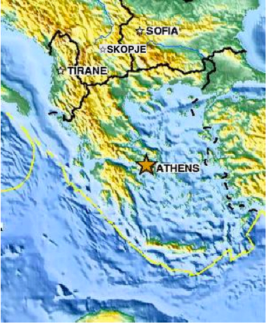
location = 38.11N 23.60E
magnitude = 6.0 Mw
countries affected = flag|Greece
casualties = 143 dead, 1,600 injured|The 1999 Athens earthquake, registering a moment magnitude of 5.9, occurred onSeptember 7 1999 , at 2:56:50 pm local time and lasted for approximately 15 seconds. The tremor was epicentered approximately 17 km to the northwest of the city center, in a sparsely populated area between the working-class town ofAcharnes and theMount Parnitha National Park. [ http://www.geo.uib.no/seismo/quakes_world/Athens-earthq/HTML/Pavlides1.htm Athens Metropolitan Earthquake, a field report by S. Pavlides, G. Papadopoulos and Th. Ganas] ] This proximity to the Athens Metropolitan Area resulted in widespread structural damage, mainly to the nearby towns ofAno Liossia ,Acharnes ,Fyli andThrakomakedones as well as to the northern Athenian suburbs ofKifissia ,Metamorfosi ,Kamatero andNea Philadelphia . More than 100 buildings (including three major factories) across those areas collapsed trapping scores of victims under their rubble while dozens more were severely damaged. Overall, 143 people lost their lives and more than 2,000 were treated for injuries in what eventually became Greece's deadliest natural disaster in almost half a century. This event took Greek seismologists by surprise as it came from a previously unknown fault, originating in an area that was for a long time considered of a particularly low seismicity.
=DaThe 1999 quake was the most devastating and costly
natural disaster to hit the country in nearly 20 years. The last major earthquake to hit Athens took place onFebruary 24 ,1981 , near the Alkyonides Islands of theCorinthian Gulf , some 77 km to the west of the Greek capital; registering a moment magnitude of 6.7, that earthquake had resulted to the death of 20 people and to considerable and widespread structural damage. Apart from the proximity of the epicenter to the Athens Metropolitan Area, this quake also featured a very shallowhypocenter combined with unusually high ground accelerations. Unexpectedly heavy damage also affected the town of Adames. [doi|10.1016/j.physletb.2003.10.071] The tangible loss was estimated at about 3 billion US dollars. No significant structural damage was reported to the municipality of Athens and the southern and eastern suburbs of the city. TheAcropolis of Athens and the rest of the city's famous ancient monuments escaped the disaster either totally unharmed or suffering only minor damage. A landslide as well as several fissures were reported along the road leading to the peak ofMount Parnitha . Minor damage was also reported to water and waste networks close to the epicenter. [A. Elenas, ATHENS EARTHQUAKE OF 7 SEPTEMBER 1999: INTENSITY MEASURES AND OBSERVED DAMAGES, ISET Journal of Earthquake Technology, Technical Note, Vol. 40, No.1, March 2003, pp. 77-97]Turkish aid
The tremor took place less than a month after a (much larger in scale) Turkish disaster. This peculiar succession of earthquakes and mutual help of both countries gave rise to talks about what became known as the "
Greek-Turkish earthquake diplomacy ", in hopes for a breakthrough in bilateral relations, which had been marred by decades of mutual hostility. Turkey reciprocated the aid rendered by Greece immediately following theAugust 17 1999 Turkish earthquake. A special taskforce was formed, consisting of the Undersecretariat of the Prime Ministry, the Turkish Armed Forces, the Ministries of Foreign Affairs and of Internal Affairs and the Greek Embassy inAnkara was contacted. The Turkish aid was the first to arrive in the affected areas, with the first 20-person rescue team arriving in Athens within 13 hours since the earthquake struck. The Greek consulates and the embassy in Turkey had their phone lines jammed with Turkish citizens offering blood donations. [ [http://www.milliyet.com.tr/1999/09/10/haber/hab00.html "Bu dostluk bitmez"] tr icon]References
Further reading
* [http://www.springerlink.com/content/u22055w7726323m7/ The Source Mechanism of the Athens Earthquake, September 7, 1999, Estimated from P Seismograms Recorded at Long Range]
*Pavlides, S., Papadopoulos, G. A., and Ganas, A., 1999. The 7th September 1999 unexpected earthquake of Athens: Preliminary results on the seismotectonic environment, 1st Conf. Advances in Natural Hazards Mitigation: Experiences from Europe and Japan, Programme-Abstracts-Reports, Athens, 3-4 November 1999, 80-85.
*Ganas, A., Papadopoulos, G., and Pavlides, S. B., 2001. The 7th September 1999 Athens 5.9 Ms earthquake: remote sensing and digital elevation model inputs towards identifying the seismic fault. International Journal of Remote Sensing, 22 (1), 191-196.
*Ganas, A., Stavrakakis, G., Lagios, E., Papadopoulos, G., & Pavlides, S., [http://www.pcigeomatics.com/services/support_center/tech_papers/aganas1.pdf Investigation of the seismic fault that ruptured during the 7/9/99 Athens earthquake using space techniques, RSPS 2001 Proceedings, Natural Hazards]
* [http://home.iitk.ac.in/~vinaykg/Iset_40_tn.pdf]
Wikimedia Foundation. 2010.