- District Heights, Maryland
-
District Heights, Maryland — City — 
SealLocation of District Heights, Maryland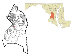
Coordinates: 38°51′34″N 76°53′21″W / 38.85944°N 76.88917°WCoordinates: 38°51′34″N 76°53′21″W / 38.85944°N 76.88917°W Country United States State Maryland County Prince George's Area – Total 0.9 sq mi (2.3 km2) – Land 0.9 sq mi (2.3 km2) – Water 0.0 sq mi (0.0 km2) Elevation 266 ft (81 m) Population (2010) – Total 5,837 Time zone Eastern (EST) (UTC-5) – Summer (DST) EDT (UTC-4) ZIP codes 20747, 20753 Area code(s) 301 FIPS code 24-23025 GNIS feature ID 0597330 District Heights is an incorporated city in. Prince George's County, Maryland, United States, located near Maryland Route 4.[1] The population was 5,837 at the 2010 census. For more information, see the separate articles on Forestville, Maryland and Suitland.
District Heights is 9.85 miles (15.85 km) away from central Washington, DC.
Contents
Geography
District Heights is located at 38°51′34″N 76°53′21″W / 38.85944°N 76.88917°W (38.859545, −76.889139)[2].
According to the United States Census Bureau, the city has a total area of 0.9 square miles (2.3 km2), all of it land.
History
District Heights was originally farm land owned by Major Leander P. Williams, purchased as four patented Lord Baltimore tracts known as: "Good Luck", "Magruder's Plains Enlarged", "the Levels", and "Offutt's Adventure". Under grants issued to Lord Baltimore by King Charles I of England, the tracts belonged to Colonel Ninian Beall, Benjamin Berry, and Alexander Magruder. District heights evolved from one of the four patents. In 1925 land purchased and formed into District Heights Company by Joseph Tepper, David L. Blanken, Henry Oxenberg, Gilbert Leventhal, Simon Gordon, and Simon Gerber. The land was farmed by Walter and Al Dustin, whose farmhouse stood at 7116 Foster Street. By 1925 streets laid out first three blocks of Halleck Street and Aztec. By 1936, the city had approximately 25 homes built , two businesses, a grocery store and filling station, a pump house and water tower to furnish the water and pressure for the City, a sewage system and a free Model T bus service to 17th and Pennsylvania Avenue, S.E.
Bordering areas
- Walker Mill (North)
- Forestville (Southeast)
- Capitol Heights (Northwest)
- Morningside (South)
Demographics
As of the 2010 Census the population of District Heights was 5,837. The racial and ethnic composition of the population was 4.25% non-Hispanic white, 89.5% non-Hispanic black, 0.2% Native American, 0.6% Asian, 1.15 from some other race and 1.9% from two or more races. 3.7% of the population was Hispanic or Latino or any race.[3]
As of the census[4] of 2000, there were 5,958 people, 2,070 households, and 1,538 families residing in the city. The population density was 6,649.1 people per square mile (2,556.0/km²). There were 2,170 housing units at an average density of 2,421.7 per square mile (930.9/km²). The racial makeup of the city was 9.20% White, 87.95% African American, 0.12% Native American, 0.86% Asian, 0.20% from other races, and 1.68% from two or more races. Hispanic or Latino of any race were 0.49% of the population.
There were 2,070 households out of which 38.3% had children under the age of 18 living with them, 39.6% were married couples living together, 28.2% had a female householder with no husband present, and 25.7% were non-families. 22.1% of all households were made up of individuals and 5.0% had someone living alone who was 65 years of age or older. The average household size was 2.88 and the average family size was 3.36.
In the city the population was spread out with 30.8% under the age of 18, 8.3% from 18 to 24, 29.3% from 25 to 44, 23.6% from 45 to 64, and 8.0% who were 65 years of age or older. The median age was 34 years. For every 100 females there were 84.9 males. For every 100 females age 18 and over, there were 76.1 males.
The median income for a household in the city was $52,331, and the median income for a family was $61,220. Males had a median income of $37,129 versus $32,443 for females. The per capita income for the city was $21,190. About 4.5% of families and 5.9% of the population were below the poverty line, including 9.0% of those under age 18 and 6.1% of those age 65 or over.
Notable residents
- Lloyd R. Woodson, arrested in 2010 with military-grade illegal weapons he intended to use in a violent crime, and a detailed map of the Fort Drum military installation
Government
The City is Governed by a Mayor and City Commission elected every 4 years.
Current Elected Mayor and City Commission
Mayor James L. Walls, Jr. (At-Large); Commissioner Eddie Martin (Ward 2); Commissioner Willie Calhoun (Ward 1); Commissioner Jack Sims (Ward 1); Commissioner Lee Collins (Ward 2)
City Website: www.districtheights.org
Law Enforcement
The District Heights Police Department (DHPD) is the primary law enforcement agency servicing a population of 6,224 within the jurisdiction of the municipality of District Heights. An agreement exists with Prince George's County Police Department and the County Sheriff that outlines mutual aid assistance. Assistance is also provided by neighboring municipal agencies[5]
The current Chief of Police is Micheal March. The DHPD has a complement of 12 sworn officers, 2 non-sworn city code enforcement officers, and 1 administrative assistant.[6]
Education
The city is served by the Prince George's County Public Schools.
Elementary schools that serve portions of the city limits include:
All of the city limits is zoned to:
High schools that serve portions of the city limits include:
- Dr. Henry A. Wise, Jr. High School [1]
- Suitland High School [2]
References
- ^ U.S. Geological Survey Geographic Names Information System: District Heights, Maryland
- ^ "US Gazetteer files: 2010, 2000, and 1990". United States Census Bureau. 2011-02-12. http://www.census.gov/geo/www/gazetteer/gazette.html. Retrieved 2011-04-23.
- ^ 2010 general profile of population and housing characteristics of District Heights from the US Census
- ^ "American FactFinder". United States Census Bureau. http://factfinder.census.gov. Retrieved 2008-01-31.
- ^ Demographics
- ^ About Us
External links
- City of District Heights
- Maryland State Archives District Heights site
- District Heights Police Department homepage
Law enforcement agencies in Maryland State County Departments Municipal Departments Aberdeen · Annapolis · Baltimore Police Department · Bel Air Police Department · Bowie · Cumberland · District Heights · Greenbelt · Hagerstown · Landover Hills · Laurel · Ocean City · Rockville · Salisbury · Seat Pleasant · Takoma · University Park · Upper MarlboroSheriff's Offices University Bowie State · Frostburg State · Salisbury · Towson · University of Baltimore · University of Maryland, Baltimore County · University of Maryland, College Park Police DepartmentCategories:- Cities in Maryland
- Baltimore–Washington metropolitan area
- Populated places in Prince George's County, Maryland
- Populated places in Maryland with African American majority populations
- Populated places established in 1925


Wikimedia Foundation. 2010.