- Mashpee, Massachusetts
-
Mashpee, Massachusetts — Town — Mashpee Town Hall

SealLocation in Barnstable County in Massachusetts
Coordinates: 41°38′54″N 70°28′54″W / 41.64833°N 70.48167°WCoordinates: 41°38′54″N 70°28′54″W / 41.64833°N 70.48167°W Country United States State Massachusetts County Barnstable Settled 1660 Incorporated 1870 Government - Type Open town meeting Area - Total 27.2 sq mi (70.6 km2) - Land 23.5 sq mi (60.8 km2) - Water 3.8 sq mi (9.7 km2) Elevation 55 ft (17 m) Population (2000) - Total 14,006 - Density 514.9/sq mi (198.3/km2) Time zone Eastern (UTC-5) - Summer (DST) Eastern (UTC-4) ZIP code 02649 Area code(s) 508 / 774 FIPS code 25-39100 GNIS feature ID 0618256 Website www.ci.mashpee.ma.us Mashpee is a town in Barnstable County, Massachusetts, United States. The population was 14,006 as of 2010.
For geographic and demographic information on specific parts of the town of Mashpee, please see the articles on Mashpee Neck, Monomoscoy Island, New Seabury, Popponesset, Popponesset Island, Seabrook and Seconsett Island.
Contents
History
Following King Phillip's War, the Wampanoag of the mainland were resettled with the Saconnet, or brought, together with the Nauset, into the praying towns in Barnstable County. In Massachusetts, Mashpee on Cape Cod was the biggest reservation. Mashpee was settled by English colonists in 1658 with the assistance of the missionary Richard Bourne from the neighboring town of Sandwich. In 1660 the Wampanoag were allotted about 50 square miles (130 km2) there, and beginning in 1665, they governed themselves with a court of law and trials.
In the year 1763 Mashpee was constituted a plantation by the king of England, against the will of the native Wampanoag. The natives were given the right to elect their own officials to maintain order. The population of the plantation declined steadily due to the conditions placed upon them. The area governed by the Mashpee tribe was integrated into the district of Mashpee in 1763, but in 1788 the state revoked their ability to self-govern, which it considered a failure. It appointed a committee to supervise the Native Americans, consisting of five white-only members.
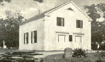
 "Old Indian Meeting House", built in 1684, oldest Native American church in the United States
A certain level of self-government was returned to the Indians in 1834, although the Wampanoag were far from completely autonomous. The state divided the Wampanoag land in 1842, with 2,000 acres (8.1 km2) of their 13,000 acres (53 km2) distributed in 60-acre (240,000 m2) parcels to each family. Many laws attest to constant problems of encroachments by whites, who also stole wood from the reservation. It was a large region, once rich in wood, fish and game, and desired by white settlers. Some had trouble ignoring the constantly growing community of non-whites, and so the Mashpee Indians had more conflicts with their white neighbors than did other Indian settlements in the state.[1] Despite these attempts at self-rule, the Wampanoag lost their land, and Mashpee was incorporated as a town in 1870, the second-to-last town on the Cape to do so (other than Bourne).
Today, the town of Mashpee is known both as a tourist destination and for its Native American culture. An annual pow-wow is held, at which the Wampanoag display traditional activities and crafts.[2]
The town's name is an Anglicization of a native name, mass-nippe, where mass is "great", or "greater" (see Massachusetts), and nippe is "water." The name has been translated as "the greater cove" or "great pond" or "land near great cove", where the water being referenced is Wakeby Lake, which is greater at one end.
Geography
According to the United States Census Bureau, the town has a total area of 27.2 square miles (70 km2), of which 23.5 square miles (61 km2) is land and 3.8 square miles (9.8 km2) (13.80%) is water.
Mashpee is considered to be on the "upper," or western, portion of Cape Cod. It is bounded by Sandwich to the north and northwest, Barnstable to the east, Nantucket Sound to the south, and Falmouth to the west. It is approximately sixty-five miles south-southeast of Boston and seventy miles east-southeast of Providence, Rhode Island.
Like all towns on the Cape, Mashpee's topography is that of sandy soil, small ponds and inlets, surrounded by the pines and oaks indigenous to the area. The town's shoreline is framed by Waquoit Bay to the west and Popponesset Bay to the east, both spawning several rivers, brooks and small ponds. The town is also the site of South Cape Beach State Park, along Dead Neck and Waquoit Bay, and the Lowell Holly Reservation, comprising the land between Wakeby and Mashpee Ponds.
Transportation
There are no freeways in the town of Mashpee. It was also the only Cape town not to have a railroad at one time or another in it, though according to 2.5. Rail Transportation, the Massachusetts Military Reservation is said to have railroad track stretching into the town. Major routes include Route 28, Route 130 and Route 151. Route 28, along with U.S. Route 6 to the north, comprise the main east-west routes along the Cape. Route 130's southern terminus lies just outside the town limits in Santuit, a village in Barnstable, and Route 151's eastern terminus is within the town, both ending at Route 28, two and a half miles apart.
There is no rail service in the town. The nearest airports (Cape Cod Airport, an airstrip for small planes, and Barnstable Municipal Airport, the largest airport on the Cape) can be found in neighboring Barnstable. The nearest national and international air service can be reached at Logan International Airport in Boston, or at T.F. Green Airport in Warwick, Rhode Island.
The Breeze bus lines also services Mashpee Commons. For a small price, one may travel along the Breeze bus lines which travel from Mashpee and into the towns of Barnstable, Sandwich, Falmouth, Bourne and Yarmouth. Bus lines and routes may be obtained at town hall or the Mashpee Commons.
Demographics
Historical populations Year Pop. ±% 1870 348 — 1880 346 −0.6% 1890 298 −13.9% 1900 303 +1.7% 1910 270 −10.9% 1920 242 −10.4% 1930 361 +49.2% 1940 434 +20.2% 1950 438 +0.9% 1960 867 +97.9% 1970 1,288 +48.6% 1980 3,700 +187.3% 1990 7,884 +113.1% 2000 12,946 +64.2% 2001* 13,504 +4.3% 2002* 13,936 +3.2% 2003* 14,163 +1.6% 2004* 14,181 +0.1% 2005* 14,170 −0.1% 2006* 14,232 +0.4% 2007* 14,249 +0.1% 2008* 14,336 +0.6% 2009* 14,365 +0.2% 2010 14,006 −2.5% * = population estimate. Source: United States Census records and Population Estimates Program data.[3][4][5][6][7][8][9][10] As of the census[11] of 2010, there were 14,006 people, 5,256 households, and 3,652 families residing in the town. The population density was 514.9 people per square mile (198.3/km²). There were 8,325 housing units at an average density of 354.6 per square mile (136.9/km²). The racial makeup of the town was 89.13% White, 2.28% African American, 3.08% Native American, 1.22% Asian, 0.06% Pacific Islander, 1.27% from other races, and 2.94% from two or more races. Hispanic or Latino of any race were 2.24% of the population.
There were 5,256 households out of which 30.8% had children under the age of 18 living with them, 55.7% were married couples living together, 11.1% had a female householder with no husband present, and 30.5% were non-families. 25.0% of all households were made up of individuals and 10.2% had someone living alone who was 65 years of age or older. The average household size was 2.44 and the average family size was 2.91.
In the town the population was spread out with 24.7% under the age of 18, 4.6% from 18 to 24, 28.4% from 25 to 44, 23.7% from 45 to 64, and 18.6% who were 65 years of age or older. The median age was 41 years. For every 100 females there were 88.9 males. For every 100 females age 18 and over, there were 85.1 males.
The median income for a household in the town was $50,871, and the median income for a family was $56,702. Males had a median income of $43,922 versus $31,416 for females. The per capita income for the town was $25,215. About 4.5% of families and 5.5% of the population were below the poverty line, including 6.6% of those under age 18 and 2.7% of those age 65 or over.
Government
Mashpee is represented in the Massachusetts House of Representatives as a part of both the Third and Fifth Barnstable districts, with the area around Otis being in the third and the southern portion of town being in the fifth. The town is represented in the Massachusetts Senate as a part of the Cape and Islands district, which includes all of Cape Cod, Martha's Vineyard and Nantucket with the exception of Bourne, Falmouth, Sandwich and portions of Barnstable.[12] The town is patrolled by the Seventh (Bourne) Barracks of Troop D of the Massachusetts State Police.[13]
On the national level, Mashpee is a part of Massachusetts's 10th congressional district, and is currently represented by Bill Delahunt. The state's senior (Class I) member of the United States Senate, re-elected in 2008, is John F. Kerry. The junior (Class II) Senator is Scott Brown.
Mashpee is governed by the open town meeting form of government, led by an executive secretary and a board of selectmen. The town operates its own police and fire departments, both of which are headquartered together near Pine Tree Corner. The town's post office and public library are also located nearby, and the library is a member of the Cape Libraries Automated Materials Sharing library network.
Voter Registration and Party Enrollment as of October 15, 2008[14] Party Number of Voters Percentage Democratic 2,715 27.20% Republican 1,636 16.39% Unaffiliated 5,600 56.11% Minor Parties 30 0.30% Total 9,981 100% Education
Mashpee has two elementary schools, one middle school, and one high school located in the town. The middle school is located in the same building as the high school, but operates under its own administration and has its own wing strictly for the 7th & 8th grade students.
- Kenneth C. Coombs School (K-2)
- Quashnet School (3–6)
- Mashpee Middle School (7–8)
- Mashpee High School (9–12)
Mashpee operates its own school system for the approximately 2,200 students in town. The Kenneth C. Coombs School (Also known as the K. C. Coombs School) is for pre-school to grade 2, the Quashnet School is for grades 3 to 6. Mashpee Middle School is for grades 7 & 8, and Mashpee High School is for grades 9 through 12. Before Mashpee High opened its doors in 1996, students residing in Mashpee attended nearby Falmouth High School. Mashpee's athletics teams are named the Falcons, and their colors are royal blue, white, and black. They compete in the South Shore League in all sports except winter track, which competes in the Eastern Athletic Conference. Mashpee High School's main rivals are Harwich High School, Abington High School and Sandwich High School. From 1999–2003. Mashpee played Sandwich High School in the annual Thanksgiving Football Game rivalry. From 2003–2009, Mashpee played Cape Cod Regional Technical High School. In 2009, Mashpee dropped the Thanksgiving rivalry with Cape Cod Tech and has since renewed the Thanksgiving rivalry with Sandwich, which is effective in the year 2010. Additionally, High school students may attend Cape Cod Regional Technical High School in Harwich free of charge. Students from Mashpee may also attend the two Catholic high schools in the area, Bishop Stang High School in Dartmouth, or the newly opened Pope John Paul II High School in Hyannis. There are also two private schools in neighboring Falmouth (Falmouth Academy) and Barnstable (Cape Cod Academy) which students may also attend.
Historic sites in Mashpee
- Old Indian Meeting House, built in 1684
- Mashpee One Room Schoolhouse, built in 1831 – open for public tours June through October
Notable residents
- Jamaal Branch – Former NFL Football Player, graduated from Falmouth High School in 1999, attended Colgate University and won the Division 1AA player of the year in 2005, was a running back for the New Orleans Saints from 2006–2008, resides in Mashpee.
- Sam Richmond – Former NFL football player for the Detroit Lions, Played football for University of Colorado-Boulder. Mid-Atlantic Prep League Player of the Year for 2001. Graduated from Mashpee High School in 2000.
- Willie Ford – Former NFL football player for Oakland Raiders, Kansas City Chiefs and Indianapolis Colts. 1997 Graduate of Falmouth High School and Syracuse University in 2002.
- Rachael Ray – Famous TV show host on The Food Channel, family owned and ran a restaurant called "The Carvery" in Mashpee.
- Carlo D'Este – Distinguished military historian and New Seabury resident
- Erik Erikson – A developmental psychologist and psychoanalyst known for his theory on social development of human beings.
- Robert Kraft – Owner of the New England Patriots, owns a residence in the Popponesset Island area of Mashpee.
- Chelsea Curtis - Professional golfer, currently signed to LPGA Futures tour. Attended Georgetown University on an athletic scholarship, Cape Cod Academy Class of 2006 graduate.
- William Rosenberg – Founder of Dunkin' Donuts, died at his home in Mashpee in 2002 at the age of 86 from bladder cancer.
- Dana Mohler-Faria – President of Bridgewater State University, resides in Mashpee.
- Dane Cook - Famous stand-up comedian that was born and raised in Mashpee.
References
- ^ Handbook of North American Indians. Chapter: "Indians of Southern New England and Long Island, late period," p. 178ff; The Seaconke Wampanoag Tribe webpage; Mashpee Wampanoag Nation webpage; Wampanoag Tribe of Gay Head Aquinnah webpage
- ^ Cape Cod, Martha's Vineyard and Nantucket Street Atlas, South Easton, MA: Arrow Maps, Inc., 2004, p. 61.
- ^ "TOTAL POPULATION (P1), 2010 Census Summary File 1, All County Subdivisions within Massachusetts". United States Census Bureau. http://factfinder2.census.gov/bkmk/table/1.0/en/DEC/10_SF1/P1/0400000US25.06000. Retrieved September 13, 2011.
- ^ "Massachusetts by Place and County Subdivision - GCT-T1. Population Estimates". United States Census Bureau. http://factfinder.census.gov/servlet/GCTTable?_bm=y&-geo_id=04000US25&-_box_head_nbr=GCT-T1&-ds_name=PEP_2009_EST&-_lang=en&-format=ST-9&-_sse=on. Retrieved July 12, 2011.
- ^ "1990 Census of Population, General Population Characteristics: Massachusetts". US Census Bureau. December 1990. Table 76: General Characteristics of Persons, Households, and Families: 1990. 1990 CP-1-23. http://www.census.gov/prod/cen1990/cp1/cp-1-23.pdf. Retrieved July 12, 2011.
- ^ "1980 Census of the Population, Number of Inhabitants: Massachusetts". US Census Bureau. December 1981. Table 4. Populations of County Subdivisions: 1960 to 1980. PC80-1-A23. http://www2.census.gov/prod2/decennial/documents/1980a_maABC-01.pdf. Retrieved July 12, 2011.
- ^ "1950 Census of Population". Bureau of the Census. 1952. Section 6, Pages 21-10 and 21-11, Massachusetts Table 6. Population of Counties by Minor Civil Divisions: 1930 to 1950. http://www2.census.gov/prod2/decennial/documents/23761117v1ch06.pdf. Retrieved July 12, 2011.
- ^ "1920 Census of Population". Bureau of the Census. Number of Inhabitants, by Counties and Minor Civil Divisions. Pages 21-5 through 21-7. Massachusetts Table 2. Population of Counties by Minor Civil Divisions: 1920, 1910, and 1920. http://www2.census.gov/prod2/decennial/documents/41084506no553ch2.pdf. Retrieved July 12, 2011.
- ^ "1890 Census of the Population". Department of the Interior, Census Office. Pages 179 through 182. Massachusetts Table 5. Population of States and Territories by Minor Civil Divisions: 1880 and 1890. http://www2.census.gov/prod2/decennial/documents/41084506no553ch2.pdf. Retrieved July 12, 2011.
- ^ "1870 Census of the Population". Department of the Interior, Census Office. 1872. Pages 217 through 220. Table IX. Population of Minor Civil Divisions, &c. Massachusetts. http://www2.census.gov/prod2/decennial/documents/1870e-05.pdf. Retrieved July 12, 2011.
- ^ "American FactFinder". United States Census Bureau. http://factfinder.census.gov. Retrieved 2008-01-31.
- ^ "Index of Legislative Representation by City and Town, from". Mass.gov. http://www.mass.gov/legis/citytown.htm. Retrieved 2010-11-07.
- ^ "Station D-7, SP Bourne". Mass.gov. http://www.mass.gov/?pageID=eopsterminal&L=5&L0=Home&L1=Law+Enforcement+%26+Criminal+Justice&L2=Law+Enforcement&L3=State+Police+Troops&L4=Troop+D&sid=Eeops&b=terminalcontent&f=msp_divisions_field_services_troops_troop_d_msp_field_troop_d_station_d7&csid=Eeops. Retrieved 2010-11-07.
- ^ "Registration and Party Enrollment Statistics as of October 15, 2008" (PDF). Massachusetts Elections Division. http://www.sec.state.ma.us/ele/elepdf/st_county_town_enroll_breakdown_08.pdf. Retrieved 2010-05-08.
External links
Municipalities and communities of Barnstable County, Massachusetts County seat: Barnstable City 
Towns CDPs Bourne | Brewster | Buzzards Bay | Chatham | Dennis | Dennis Port | East Dennis | East Falmouth | East Harwich | East Sandwich | Falmouth | Forestdale | Harwich Center | Harwich Port | Mashpee Neck | Monomoscoy Island | Monument Beach | New Seabury | North Eastham | North Falmouth | Northwest Harwich | Orleans | Pocasset | Popponesset Island | Popponesset | Provincetown | Sagamore | Sandwich | Seabrook | Seconsett Island | South Dennis | South Yarmouth | Teaticket | West Chatham | West Dennis | West Falmouth | West Yarmouth | Woods Hole | Yarmouth Port
Other
villagesBarnstable Village | Centerville | Cotuit | Craigville | Hyannis | Marstons Mills | Menauhant | North Harwich | North Truro | Osterville | Pleasant Lake | South Harwich | West Barnstable | West Harwich
Categories:- Populated coastal places in Massachusetts
- Towns in Barnstable County, Massachusetts
- Mashpee, Massachusetts
- Populated places established in 1660


Wikimedia Foundation. 2010.