- North India
-
Contents
Heading text
Northern India
उत्तर भारत اُتر بھارت
शुमाली हिन्दुस्तान شُمالی ھندوستان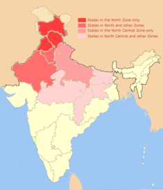
States in the North and North Central Zones of India, as defined by the Indian Government.Population 504,196,432 Area 1,624,160 km2 (627,090 sq mi) Time zone IST (UTC+5:30) States and territories Jammu and Kashmir, Himachal Pradesh, Uttarakhand, Haryana, Punjab, Rajasthan, Uttar Pradesh, Bihar, Jharkhand, Chhattisgarh and Madhya Pradesh Most populous cities (2008) New Delhi, Kanpur, Lucknow, Jaipur, Patna, Chandigarh, & Varanasi Official languages English, Hindi, Urdu, Kashmiri, Dogri, Punjabi, Bhojpuri, Maithili, Santhali North India, known natively as Uttar Bhārat (Devanagari: उत्तर भारत, Nastaleeq: اُتر بھارت) or Shumālī Hindustān (Devanagari: शुमाली हिन्दुस्तान, Nastaleeq: شُمالی ھندوستان), is a loosely defined region in the northern part of India. The exact meaning of the term varies by usage. The dominant geographical features of North India are the Indo-Gangetic Plain and the Himalayas, which demarcate the region from Tibet and Central Asia. North India has been the historical center of the Maurya, Gupta, Mughal, Maratha, Sikh and British Indian Empires. It has a diverse culture, and includes the Hindu pilgrimage centers of Char Dham, Haridwar, Mathura, Allahabad and Varanasi, the Buddhist Mahabodhi Temple, the Sikh Golden Temple and the Muslim pilgrimage destination of Ajmer, as well as world heritage sites such as the Valley of flowers, Khajuraho, Bhimbetka Caves, Qutb Minar and the Taj Mahal.
Definitions
Different authorities and sources in literature define North India differently.
Government of India definition
The Government of India defines the North India Cultural Zone as including the states of Jammu and Kashmir, Punjab, Himachal Pradesh, Haryana and Rajasthan, as well as the Union Territory of Chandigarh.[1] There is an overlapping neighboring region, called the North Central India Cultural Zone, including the states of Madhya Pradesh, Chhattisgarh, Rajasthan, Haryana, Bihar, Jharkhand, Uttar Pradesh, Uttarakhand and Delhi, that is also defined by the Indian Government.[2] The states of Bihar and Jharkhand are also included in the East India Cultural Zone.[3] Similarly, Rajasthan is also included in the West India Cultual Zone,[4] and the states of Madhya Pradesh and Chhattisgarh are also included in the South Central India Cultural Zone.[2]
Linguistic definition
Indo-Aryan languages predominate in North India. This includes the Hindi Heartland, where Hindi and related languages predominate. Prior to the Partition of India, this also included the Pakistani provinces of Sindh[5] and Punjab, and the eastern portion of the North West Frontier Province up to Peshawar valley where Punjabi dialects and Hindko are spoken.[6] This effectively excludes several of the seven North-East states (except for Assam and Sikkim).[7][8]
 Vasudeva I (c. 200CE) was the last great Kushan king of North India and Bactria. One side of this coin shows him, and the other the Nandi bull with a trishul-holding divinity that combines aspects of the Hindu God Shiva and the Zoroastrian divinity Vayu-Vata. After him, the Indo-Sassanids displaced Kushan rule in North India.
"North of the Vindhyas"
One traditional, and now obsolete, demarcation between Northern and Southern India is the Vindhya mountain range, which has sometimes formed a border during periods of imperial expansion in India, such as the one ruled by the Gupta emperor Samudragupta.[9] The Vindhyas also find mention in the narrative of Rishi Agastya as a dividing feature between North and South India.[10] The Manusmṛti also describes the southern limit of Aryavarta (a classical, and also now obsolete, term for parts of North India) as being defined by the Vindhya range.[11]
Muslim, Central Asian and Persian impacts as defining influences
Several sources consider sizable Muslim populations and deep-seated Islamic, Central Asian and Persian influences to be defining characteristics of North Indian culture, both linguistically and culturally.[12][13] Some of these influences are pre-Islamic, such as the Bactrian-originated Kushan Empire that maintained twin capitals in Mathura (now in Uttar Pradesh) and Peshawar (in the North West Frontier Province), as well as the Hun confederacies that periodically asserted their rule over large parts of North India.[14]
Latitude-based definition
The Tropic of Cancer, which divides the temperate zone from the tropical zone in the Northern Hemisphere of the planet, runs through India, and could theoretically be regarded as a geographical dividing line in the country.[15]
Anecdotal usage
The term "North Indian" is sometimes used to describe people from Uttar Pradesh and Bihar, often using the term bhaiya (which literally means 'elder brother') in a derogatory sense, though some press reports have contradicted this.[16] In Punjab, people from the same region (Uttar Pradesh and Bihar) are often referred to as Purabias, or Easterners.[17] Some publications of the Government of Bihar place that state in the eastern part of India as well.[18] Within Uttar Pradesh itself, "the cultural divide between the east and the west is considerable, with the purabiyas (easterners) often being clubbed with Biharis in the perception of the westerners."[19][20] Punjab is sometimes considered a north-western state, as are Gujarat and the western parts of Uttar Pradesh.[21][22][23]
Geography
 Shilla (7026 m) above the Spiti Valley in Himachal Pradesh
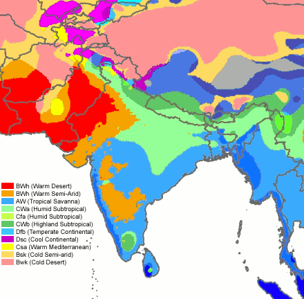
 North India has extremely diverse climates.
North India lies mainly on continental India, north of peninsular India. Towards its North are the Himalayas which define the boundary between the Indian subcontinent and the Tibetan plateau. To its west is the Thar desert, shared between North India and Pakistan and the Aravalli Range, beyond which lies the state of Gujarat. The Vindhya mountains are, in some interpretations, taken to be the southern boundary of North India.
The predominant geographical features of North India are the Indo-Gangetic plain which spans the states of Punjab, Haryana, Uttar Pradesh, Madhya Pradesh, Bihar, Jharkhand and West Bengal, the Himalayas which lie in the states of Uttarakhand, Himachal Pradesh and Jammu and Kashmir and the Thar desert which lies mainly in the state of Rajasthan. The state of Madhya Pradesh has large areas under forest cover, as do Himachal Pradesh, Uttarakhand and Chattisgarh.[24]
General climate
 The Thar desert near Jaisalmer, Rajasthan
North India lies mainly in the north Temperate zone of the earth.[25] Though cool or cold winters, hot summers and moderate monsoons are the general pattern, North India is one of the most climatically diverse regions on Earth[original research?]. Extreme temperatures have ranged from −45 °C (−49 °F) in Dras, Jammu and Kashmir[26] to 50.6 °C (123 °F) in Alwar, Rajasthan. Dras is claimed to be the second coldest inhabited place on the planet (after Siberia), with a recorded low of -60°C.[27][28][29]
Precipitation
The region receives rain and snow precipitation through two primary weather patterns: the Indian Monsoon and the Western Disturbances. The Monsoon carries moisture northwards from the Indian Ocean, occurs in late summer and is important to the Kharif or autumn harvest.[30][31] Western Disturbances, on the other hand, are an extratropical weather phenomenon that carry moisture eastwards from the Mediterranean Sea, the Caspian Sea and the Atlantic Ocean.[32][33][34][35] They primarily occur during the winter season and are critically important for the Rabi or spring harvest, which includes the main staple over much of North India, wheat.[33] The states of Jammu and Kashmir, Himachal Pradesh and Uttarakhand receive sustained snowfall in winter months.
Demographics
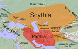 During the Scythian migrations around 100BC, a large part of North India was incorporated into the Scythian world.
The people of North India are predominantly Indo-Aryan,[36][37] and include various ethnic groups such as Brahmins, Ahirs, Jats, Rajputs, Gurjars, Khatris, Kambojs, Banias and Dalits.[38][39][40] Over millennia, the region has experienced sustained incursions and immigration from the northwest, including the Indo-Scythians,[41] Indo-Sassanids,[42][43] Indo-Hephthalites,[44][45] Kushans[46][47] and Rohilla Pashtuns.
Hinduism, Islam and Sikhism are the dominant religions in North India. Other religions practiced by various ethnic communities include Jainism and Buddhism. The states of Uttarakhand, Rajasthan, Haryana, Madhya Pradesh, Chhattisgarh and Himachal Pradesh are overwhelmingly Hindu.[citation needed] Jammu and Kashmir is the only state in India with a majority Muslim population,[citation needed] while Punjab is the only state with a majority Sikh population. Uttar Pradesh, Bihar and Jharkhand are predominantly Hindu with other minorities.
Performing arts
Dance
Dance of North India too has diverse folk and classical forms. Among the well-known folk dances are the bhangra of the Punjab, the ghoomar of Rajasthan, and rouf and bhand pather of Kashmir. Main dance forms, many with narrative forms and mythological elements, have been accorded classical dance status by India's National Academy of Music, Dance, and Drama such as kathak of Uttar Pradesh.
Languages
 Distribution of Indo-Aryan languages.
Linguistically, North India is dominated by Indo-Aryan languages, although subregions of Northern Dravidian languages (such as Bihar's Kurukh language), Tibeto-Burman languages (such as Himachal's Lahauli language) and Austro-Asiatic languages (such as Munda) exist throughout the region. It is in this region, or its proximity, that Sanskrit and the various Prakrits are thought to have evolved. Indo-Aryan languages native to North India include the Hindustani lingua franca (including both its Hindi and Urdu registers),[48][49] a wide range of western and eastern Hindi dialects, Bihari languages (Bhojpuri, Magadhi, Maithili and Angika), Pahari, Kumaoni, Garhwali, Punjabi, Kashmiri, and other languages. The subregion where Hindi languages are widely spoken (as either primary or secondary languages) is sometimes called the Hindi Heartland or the Hindi Belt, and is loosely defined.[50][51][52]
Small speaker populations of two language isolates (Nihali and Burushaski), which are not known to be rooted in any other language families, also exist in North India.[53][54]
Flora and fauna
 Further information: Wildlife of India
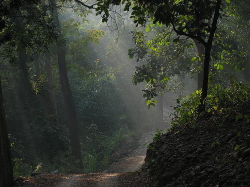
North Indian vegetation is predominantly deciduous and coniferous. Of the deciduous trees, sal, teak, walnut, sheesham (Indian rosewood) and poplar are some which are important commercially.[55] The Western Himalayan region abounds in chir, pine, deodar (Himalayan cedar), blue pine, spruce, various firs, birch and junipers.[56][57][58][59] The birch, especially, has historical significance in Indian culture due to the extensive use of birch paper (Sanskrit: bhurja patra) as parchment for many ancient Indian texts.[60][61] The Eastern Himalayan region consists of oaks, laurels, maples, rhododendrons, alder, birch and dwarf willows. Reflecting the diverse climatic zones and terrain contained in the region, the floral variety is extensive and ranges from Alpine to temperate thorn, coniferous to evergreen, and thick tropical jungles to cool temperate woods.[56][62]
There are around 500 varieties of mammals, 2000 species of birds, 30,000 types of insects and a wide variety of fish, amphibians and reptiles in the country. Animal species in North India include Elephant, Tiger, Leopard, Snow Leopard, Sambar (Asiatic stag), Chital (Spotted deer), Hangul (Red deer), Hog Deer, Chinkara (Indian Gazelle), Blackbuck, Nilgai (blue bull antelope), Porcupine, Wild Boar, Indian Fox, Tibetan Sand Fox, Rhesus Monkey, Langur, Jungle Cat, Hyena, Jackal, Black Bear, Himalayan Brown Bear, Sloth Bear, and the endangered Caracal.
Reptiles are represented by a large number of snake and lizard species, as well as the ghariyal and crocodiles.[63] Venomous snakes found in the region include king cobra and krait. Various scorpion, spider and insect species include the commercially useful honeybees, silkworms and lac insects. The strikingly colored bir bahuti is also found in this region.[64]
The region has a wide variety of birds, including peacocks, parrots, and thousands of immigrant birds, such as the Siberian Crane. Other birds include pheasants, geese, ducks, mynahs, parakeets, pigeons, cranes (including the celebrated Sarus Crane), and hornbills. Great pied hornbill, Pallas's fishing eagle, Grey-headed fishing eagle, Red-thighed falconet are found in the Himalayan areas. Other birds found here are Tawny fish owl, Scaly-bellied Woodpecker, Red-breasted Parakeet, Himalayan Swiftlet, Stork-billed Kingfisher and Himalayan or White-tailed Rubythroat.[65][66]
Wildlife parks and reserves
Important National Parks and Tiger reserves of North India include -
 Jim Corbett National Park
Corbett National Park: It was established in 1936 along the banks of the Ramganga River. It is India's first National Park, and was designated a Project Tiger Reserve in the year 1973. Situated in Nainital district of Uttarakhand the park acts as a protected area for the critically endangered Bengal tiger of India. Cradled in the foothills of the Himalayas, it comprises a total area of 500 km² out of which 350 km² is core reserve. This park is known not only for its rich and varied wildlife but also for its scenic beauty.
Dachigam National Park: Dachigam is a higher altitude national reserve in the state of Jammu and Kashmir that ranges from 5,500 to 14,000 feet above sea level. It is home to the Hangul (a Red Deer species, also called the Kashmir Stag).
Great Himalayan National Park: This park is located in Himachal Pradesh state and ranges in altitude from 5,000 to 17,500 feet. Wildlife resident here includes the Snow Leopard, the Himalayan Brown Bear and the Musk deer.
Desert National Park: Located in Rajasthan, this national reserve features extensive sand dunes and dry salt lakes. Wildlife unique to the region includes the Desert Fox and the Great Indian Bustard.
Kanha National Park: The sal and bamboo forests, grassy meadows and ravines of Kanha were the setting for Rudyard Kipling's collection of stories, "The Jungle Book". The Kanha National Park in Madhya Pradesh came into being in 1955 and forms the core of the Kanha Tiger Reserve, created in 1974 under Project Tiger.
Vikramshila Gangetic Dolphin Sanctuary: Located in the state of Bihar, it is the only protected zone for the endangered Ganges and Indus River dolphin.
Bharatpur Bird Sanctuary: It is one of the finest bird parks in the world, it is a reserve that offers protection to faunal species as well. Nesting indigenous water birds as well as migratory water birds and waterside birds, this sanctuary is also inhabited by Sambar, Chital, Nilgai and Boar.
Dudhwa National Park: It covers an area of 500 km² along the Indo-Nepal border in Lakhimpur Kheri district of Uttar Pradesh, is best known for the Barasingha or Swamp Deer. The grasslands and woodlands of this park, consist mainly of sal forests. The barasingha is found in the southwest and southeast regions of the park. Among the big cats, tigers abound at Dudhwa. There are also a few leopards. The other animals found in large numbers, are the Indian rhinoceros and the wild elephant, jungle cats, leopard cats, fishing cats, jackals, civets, sloth bears, sambar, otters, crocodiles and chital.
Ranthambhore National Park: It spans an area of 400 km² with an estimated head count of thirty two tigers is perhaps India’s finest example of Project Tiger, a conservation effort started by the government in an attempt to save the dwindling number of tigers in India. Situated near the small town of Sawai Madhopur it boasts of variety of plant and animal species of North India.
Kalesar National Park: Kalesar is a sal forest in the Shivalik Hills of eastern Haryana state. Primarily known for birds, it also contains a small number of tigers and panthers.
Places of interest
The largest Hindu temple in India, Akshardham Temple, and the largest mosque, Jama Masjid, are both located in this region.[67][68] The Taj Mahal,An immense mausoleum of white marble, built in Agra between 1631 and 1648 by order of the Mughal emperor Shah Jahan in memory of his favourite wife, the Taj Mahal is the jewel of Muslim art in India and one of the universally admired masterpieces of the world's heritage.Cite error: Closing
</ref>missing for<ref>tag; see the help pageUniversities in North India
North India has several universities and centres of excellence such as the University of Kashmir, University of Jammu, Haryana Agricultural University, Guru Jambheshwar University of Science & Technology, Agra University, Aligarh Muslim University, University of Rajasthan, All India Institute of Medical Sciences, Allahabad University, Benaras Hindu University, Birla Institute of Technology and Science, Delhi University, Govind Ballabh Pant University of Agriculture & Technology, Gurukul Kangri University, Jawaharlal Nehru University, Kanpur University, Noida International University, University of Lucknow, Kurukshetra University, Panjab University and many more. The world renowned Indian Institute of Technology and Indian Institute of Management, have campuses in several cities of North India such as Delhi, Kanpur, Varanasi Lucknow, Indore, and Ahmedabad. One of the first great universities in recorded history, the Nalanda University, is located in the state of Bihar. There has been various plans for revival of this ancient university, including an effort by a multinational consortium led by Singapore, China, India and Japan.
Economy
Further information: Economy of IndiaOnce predominantly agrarian, the economic landscape is changing fast with rapid economic growth that has ranged above 8% annually. Several parts of North India have prospered as a consequence of the Green Revolution, including Punjab, Haryana and Western Uttar Pradesh, and experienced both economic and social development.[69][70][71] The eastern areas of East Uttar Pradesh and Bihar, however, have lagged[72][73] and the resulting disparity has, in the case of Uttar Pradesh, contributed to a demand for separate statehood in West Uttar Pradesh (the Harit Pradesh movement).[74][75] Bihar has the lowest per-capita SDP.
The highest per capita income states in North India include Haryana, Himachal Pradesh, Punjab and Uttarakhand and union territories of Delhi and Chandigarh.[76] Reflecting the prosperity of the western part of North India, Chandigarh has the highest per-capita State Domestic Product (SDP) of any Indian state or union territory, while Delhi, Punjab and Haryana rank second, third and fourth (after Goa) among the states (see main article: States of India by size of economy).[77]
See also
- India
- North-East India
- West India
- Central India
- East India
- South India
References and bibliography
- ^ "North Zone Cultural Centre". North Zone Cultural Center, Sheesh Mahal, Patiala, Punjab. http://www.culturenorthindia.com/. Retrieved 2008-10-16.
- ^ a b "North Central Zone Cultural Centre". North Central Zone Cultural Center, Allahabad, Uttar Pradesh. http://www.nczccindia.org/index1.html. Retrieved 2008-10-16.
- ^ "East Zone Cultural Centre". East Zone Cultural Center, Kolkata, West Bengal. http://ezccindia.org/aboutus.html/index1.html. Retrieved 2008-10-18.[dead link]
- ^ "West Zone Cultural Centre". West Zone Cultural Center, Udaipur, Rajasthan. http://www.wzccindia.com/. Retrieved 2008-10-18.
- ^ Sheldon I. Pollock, "Literary Cultures in History: Reconstructions from South Asia", University of California Press, 2003, ISBN 0-520-22821-9.
- ^ Dhanesh Jain and George Cardona, "The Indo-Aryan Languages", Routledge, 2003, ISBN 0-7007-1130-9.
- ^ Golockchandra Goswami (1982), Structure of Assamese, Dept. of Publication, Gauhati University, http://books.google.com/books?id=dwwIAQAAIAAJ, "... Assamese is an Indo-Aryan language originated from the Vedic dialects, and therefore, a sister of all the northern Indian languages of the country ..."
- ^ Peter Austin (2008), One thousand languages: living, endangered, and lost, University of California Press, ISBN 9780520255609, http://books.google.com/books?id=Q3tAqIU0dPsC, "... Nepali is an Indo-Aryan language spoken in Nepal, in the north Indian state of Sikkim and some other parts of India, and in Bhutan and Burma ..."
- ^ John Stewart Bowman, "Columbia Chronologies of Asian History and Culture", Columbia University Press, 2000, ISBN 0-231-11004-9, Snippet:... Samudragupta is notable for the king's tireless military campaigning and expansion of empire. He conquers the entire Aryavarta ... His expeditions into south India are unsuccessful; the Vindhya hills form the southern boundary of empire ....
- ^ Varadaraja V. Raman, "Glimpses of Indian Heritage", Popular Prakasan, 1989.
- ^ Kallidaikurichi Aiyah Nilakanta Sastri (1976), A history of South India from prehistoric times to the fall of Vijayanagar, Oxford University Press, http://books.google.com/books?id=FjxuAAAAMAAJ, "... The Vindhya range was the recognized southern limit of the Aryan land. Manu states distinctly that the country between the Himalayas and the Vindhyas and between the eastern and western oceans comprised Aryavarta, the abode of the Aryas ..."
- ^ Paul R. Brass, "Language, Religion and Politics in North India", iUniverse, 2005, ISBN 0-595-34394-5.
- ^ Christopher Alan Bayly, "Rulers, Townsmen, and Bazaars: North Indian Society in the Age of British Expansion, 1770-1870", CUP Archive, 1983, ISBN 0-521-31054-7.
- ^ Romila Thapar, "Early India: From the Origins to AD 1300", University of California Press, 2003, ISBN 0-520-24225-4.
- ^ Ram Nath Dubey, "Economic Geography of India", Kitab Mahal, 1961. ... The Tropic of Cancer divides India roughly into two equal parts: the Warm Temperate and Tropical ...
- ^ A clash of cultures, NDTV, 2008-02-25. Retrieved 2008-10-22. "... no one in North India, and here I am talking of the states of Punjab, Himachal, Uttrakhand, Haryana and Rajasthan, considers people from eastern UP and Bihar as North Indians ..."
- ^ "Politicians to blame for low turnout". The Tribune, Chandigarh. 2001-12-11. http://www.tribuneindia.com/2001/20011211/cth1.htm. Retrieved 2008-10-21.
- ^ "Government of Bihar Official Web Portal". Government of Bihar. http://gov.bih.nic.in/Profile/default.htm. Retrieved 2008-10-18.
- ^ "Unorganised Workers of Delhi and the Seven Day Strike of 1988". Indrani Mazumdar, Archives of Indian Labour. http://www.indialabourarchives.org/publications/Indrani%20Mazumdar.htm. Retrieved 2008-10-21.
- ^ Susheela Raghavan, "Handbook of Spices, Seasonings, and Flavorings", CRC Press, 2007, ISBN 0-8493-2842-X. ... Maharashtra, in North India, has kala masala in many versions ...
- ^ Some facts about Punjab
- ^ "Gujarat State Petroleum Corporation makes giant Indian gas find". BBC. 2005-06-26. http://news.bbc.co.uk/1/hi/business/4624407.stm. Retrieved 2010-04-09.
- ^ David Levinson and Karen Christensen, "Encyclopedia of Modern Asia", Charles Scribner Sons, 2002, ISBN 0-684-31242-5. ... Agra, located in the state of Uttar Pradesh in northwest India, is renowned ...
- ^ "Forest Survey of India - State of Forest Report 2003". Ministry of Environment & Forests, Government of India. http://www.fsi.nic.in/sfr_2003.htm. Retrieved 2008-10-20.
- ^ Yash Pal Singh, Social Science Textbook for Class IX Geography, VK Publications, ISBN 9788189611156, http://books.google.com/books?id=hvq7wTsNxoQC, "... The Tropic of Cancer divides India into almost two equal parts. It makes the Southern half of India in the Tropical Zone and the Northern half in the Temperate zone ..."
- ^ Weatherbase: Historical Weather for Dras, India
- ^ Sarina Singh, "India: Lonely Planet Guide", Lonely Planet, 2003, ISBN 1-74059-421-5.
- ^ H. N. Kaul, Rediscovery of Ladakh, Indus Publishing, 1998, ISBN 8173870861, 9788173870866, http://books.google.com/books?id=mg8My6WaWRcC, "... With its altitude of 10000 ft. above the sea, Dras is considered to be the second coldest inhabited place in the world after Siberia where mercury sinks as low as -40°C during winter, though it has also recorded a low of -60°C ..."
- ^ Galen A. Rowell, Ed Reading, Many people come, looking, looking, Mountaineers, 1980, ISBN 0916890864, 9780916890865, http://books.google.com/books?id=ZjsTAQAAIAAJ, "... the bleak village of Dras, reportedly the second coldest place in Asia with recorded temperatures of -80°F ..."
- ^ Vidya Sagar Katiyar, "Indian Monsoon and Its Frontiers", Inter-India Publications, 1990, ISBN 81-210-0245-1.
- ^ Ajit Prasad Jain and Shiba Prasad Chatterjee, "Report of the Irrigation Commission, 1972", Ministry of Irrigation and Power, Government of India, 1972.
- ^ "Western disturbances herald winter in Northern India". The Hindu Business Line. 2005-11-17. http://www.thehindubusinessline.com/2005/11/17/stories/2005111702801900.htm. Retrieved 2008-10-20.
- ^ a b Bin Wang, "The Asian Monsoon", Springer, 2006, ISBN 3-540-40610-7.
- ^ R.K. Datta (Meteorological Office, Dum Dum) and M.G. Gupta (Meteorological Office, Delhi), "Synoptic study of the formation and movements of Western Depressions", Indian Journal of Meteorology & Geophysics, India Meteorological Department, 1968.
- ^ A.P. Dimri, "Models to improve winter minimum surface temperature forecasts, Delhi, India", Meteorological Applications, 11, pp 129-139, Royal Meteorological Society, Cambridge University Press, 2004.
- ^ Alan A. Lew, Colin Michael Hall, Dallen J. Timothy (2008), World geography of travel and tourism: a regional approach, Butterworth-Heinemann, ISBN 9780750679787, http://books.google.com/books?id=BBa_LZhCPYoC, "... The major racial groups include the Indo-Aryan peoples who live predominantly in the north ..."
- ^ Phani Deka (2007), The great Indian corridor in the east, Mittal Publications, ISBN 9788183241793, http://books.google.com/books?id=DPWGpVvBvx8C, "... So far the present ethnic composition is concerned, of the country's total population the Indo-Aryans constitute 72 percent, Dravidians 25 percent, and Mongoloids, Proto-Australoids and Negritos together remaining 3 per cent ..."
- ^ Sarat Chandra Roy and Ral Bahadur, "Man in India", A.K. Bose, 1996.
- ^ Kumool Abbi, "Discourse of Zindaginama: A semio-anthropological critique", Harman Publishing House, 2002.
- ^ Kiran Prem, Haryana Gazetteers Organization, "Haryana District Gazetteers", Government of Haryana, 1970.
- ^ Richard Ernest Dupuy and Trevor Nevitt Dupuy, "The Encyclopedia of Military History: From 3500 BC to the Present", Macdonald and Jane's, 1977, ISBN 0-06-011139-9.
- ^ Thomas George Percival Spear, "India: A modern history", University of Michigan Press, 1972, ISBN 0-472-07140-8.
- ^ Claude Markovits, "The Global World of Indian Merchants, 1750-1947: Traders of Sind from Bukhara to Panama", Cambridge University Press, 2000, ISBN 0-521-62285-9.
- ^ Vincent A. Smith, "Early History of India from 600 B.C. to the Muhammadan Conquest", The Clarendon press, 1914.
- ^ Vidya Dhar Mahajan, "Ancient India", S. Chand & Co., 1968.
- ^ Michael Edwardes, "A History of India from the Earliest Times to the Present Day: From the Earliest Times to the Present Day", Thames and Hudson, 1961.
- ^ Alexander Cunningham, "Coins of the Indo-Scythians, Sakas & Kushans", Indological Book House, 1971.
- ^ Prabodh Bechardas Pandit, "Language in a Plural Society", Dev Raj Chanana Memorial Committee, 1977.
- ^ Robert McHenry, "The New Encyclopaedia Britannica", Encyclopaedia Britannica, 1993.
- ^ B.L. Sukhwal (1985), Modern Political Geography of India, Stosius Inc/Advent Books Division, http://books.google.com/books?id=HemAAAAAIAAJ, "... In the Hindi heartland ..."
- ^ Stuart Allan, Barbie Zelizer (2004), Reporting war: journalism in wartime, Routledge, ISBN 0415339987, http://books.google.com/books?id=skdoYDs1e8AC, "... located in what is called the "Hindi heartland" or the "Hindi belt" of north and central India ..."
- ^ B.S. Kesavan (1997), Origins of printing and publishing in the Hindi heartland (Volume 3 of History of printing and publishing in India : a story of cultural re-awakening), National Book Trust, ISBN 812372120X, http://books.google.com/books?id=8JDgAAAAMAAJ
- ^ David Lockhart Robertson Lorimer (1938), The Burushaski language, Part I, H. Aschehoug, http://books.google.com/books?id=rVweAAAAIAAJ, "... Burushaski has ... small numbers are to be found in Srinagar and down country, even in Bombay ..."
- ^ Braj B. Kachru, Yamuna Kachru, S. N. Sridhar (2008), Language in South Asia, Cambridge University Press, ISBN 0521781418, http://books.google.com/books?id=O2n4sFGDEMYC, "... Nihali, which has some 2000 speakers in the Indian state of Maharashtra is generally also regarded as an isolate ..."
- ^ N.C. Saxena, "The Saga of Participatory Forest Management in India", Center for International Forestry Research, 1997, ISBN 979-8764-15-3.
- ^ a b R.L. Singh, "India: A Regional Geography", National Geographical Society of India, 1971.
- ^ Bansi Lal Kaul, "Ecodegradation of Himalayas", Vinod Publishers & Distributors, 1995.
- ^ S.S. Negi, "Himalayan Forests and Forestry", Indus Publishing, 2002, ISBN 81-7387-112-4. Snippet:... Important Himalayan trees are sal, chir pine, deodar, oaks, fir, spruce, rhododendrons, and the giant evergreen trees of the Eastern Himalayas ...
- ^ R.P. Sharma, "The Indian Forester", v.72:6-12 (Jan-June 1946).
- ^ Sanjukta Gupta, "Lakṣmī Tantra: A Pāñcarātra Text", Brill Archive, 1972, ISBN 90-04-03419-6. Snippet:... the text recommends that the bark of the Himalayan birch tree (bhurja-patra) should be used for scribbling mantras ...
- ^ Amalananda Ghosh, "An Encyclopaedia of Indian Archaeology", BRILL, 1990, ISBN 90-04-09264-1. Snippet:... Bhurja-patra, the inner bark on the birch tree grown in the Himalayan region, was a very common writing material ...
- ^ Casey A. Wood, "Through Forest and Jungle in Kashmir and Other Parts of North India: The Annual Smithsonian Institution Report, 1932", Government Printing Office, Washington, D.C., 1933.
- ^ North India Online - India - Flora and Fauna - Animals - Trees - Birds - Mammals - Insects
- ^ John Shakespear (1817), Dictionary: Hindustani and English, Taylor & Francis, http://books.google.com/?id=31cVAAAAIAAJ, "... bir bahuti: a small insect with a back of a bright red color; the scarlet or lady fly, commonly called the "Rain insect" as it makes its appearance when the first rains have fallen ..."
- ^ INDIAN GEOGRAPHY - indian rivers, indian flora & fauna wildlife, national symbols in india
- ^ "Flora & Fauna North India". Archived from the original on August 18, 2007. http://web.archive.org/web/20070818212629/http://www.corbettnationalpark.com/wildpackage.htm. Retrieved 2007-09-15.
- ^ Largest Hindu Temple: Guinness World Records
- ^ Masjid-i-Jahan Numa
- ^ Mohamad Riad El Ghonemy, "The Dynamics of Rural Poverty", Food and Agriculture Organization of the United Nations, 1986. ... Haryana and West Uttar Pradesh recorded spectacular production increases ...
- ^ V. G. Rastyannikov, "Agrarian Evolution in a Multiform Structure Society: Experience of Independent India", Routledge & Kegan Paul, 1981, ISBN 0-7100-0755-8.
- ^ B. M. Bhatia, "Food Security in South Asia", Oxford & IHB Pub. Co., 1985.
- ^ Robert E. B. Lucas, Gustav Fritz Papanek, "The Indian Economy: Recent Development and Future Prospects", Westview Press, 1988, ISBN 0-8133-7505-3.
- ^ Gilbert Etienne, "Rural Development In Asia: Meetings With Peasants", Sage Publications, 1985, ISBN 0-8039-9495-8.
- ^ Gyanesh Kudaisya, "Region, Nation, Heartland: Uttar Pradesh in India's Body Politic", Sage Publications, 2006, ISBN 0-7619-3519-3.
- ^ "RLD, BSP gear up as Mulayam exit looms". The Tribune, Chandigarh. 2007-02-19. http://www.tribuneindia.com/2007/20070219/nation.htm#1. Retrieved 2008-10-18.
- ^ .These north indian states form the most prosperous region of India with high per capita income and lower poverty levels.The National Capital Region of Delhi has emerged as an economic power house with rapid industrial growth along with adjoining areas of Uttar Pradesh, Haryana and Rajasthan. "thehindubusinessline.com". http://www.thehindubusinessline.com/2004/08/19/stories/2004081900500500.htm. Retrieved 2007-11-10.
- ^ "Ministry of Statistics and Programme Implementation - Publications". Government of India. http://mospi.nic.in/cso_rept_pubn.htm. Retrieved 2008-10-18.
External links
Topics related to Geography of India Climate Geology Geology · Geological historyLandforms Beaches · Desert · Extreme points · Glaciers · Islands · Lakes · Mountains · Rivers · Valleys · Volcanoes · Waterfalls
Plains (Gangetic Plains · Eastern Coastal · Western Coastal)Regions Subdivisions Environment Biosphere Reserves · Ecoregions · Fauna · Flora · National Parks · Protected Areas · Sanctuaries · WildlifeCategories:- Regions of India


Wikimedia Foundation. 2010.