- Motspur Park
-
Coordinates: 51°25′N 0°15′W / 51.41°N 0.25°W
Motspur Park 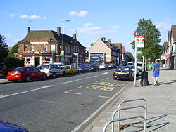
The suburban shopping parade at Motspur Park dates from the 1930s
 Motspur Park
Motspur Park shown within Greater LondonOS grid reference TQ225677 London borough Kingston Merton Ceremonial county Greater London Region London Country England Sovereign state United Kingdom Post town NEW MALDEN Postcode district KT3 Dialling code 020 Police Metropolitan Fire London Ambulance London EU Parliament London UK Parliament Mitcham and Morden Kingston and Surbiton London Assembly South West Merton and Wandsworth List of places: UK • England • London Motspur Park, also known locally as West Barnes is a suburb in South West London situated across the boundary between the London Borough of Merton and the Royal Borough of Kingston upon Thames. It owes its identity to the railway station of the same name, which has six trains an hour to London's Waterloo, and to the adjacent parade of small shops. Two prominent gas holders, which are used to store the consumer gas supply for south west London stand just south of the shopping parade and can be seen from a wide area.
Two of London’s minor natural water courses run through the area. The Beverley Brook runs south to north through its centre and its smaller tributary the Pyl Brook runs parallel further to the east. These have in the past given rise to some local flooding.
The Motspur Park athletics stadium was built by the University of London in 1928 and achieved fame when the world mile record was set there in 1938. It was sold to Fulham Football Club as their training ground in 1999.[1]
Contents
History
The district was historically known as West Barnes and formed part of the traditional county of Surrey. It was rural right up to the end of the nineteenth century when the railway station was built. Two local lanes, West Barnes Lane and Blakes Lane, represent remnants from this rural era. The barns referred to were those at the western end of Merton Abbey's estates and were just north of West Barnes Lane's junction with the modern Crossway.
After the dissolution of the monasteries the abbey land was granted to the Gresham family , (descendants of Thomas Gresham) who were wealthy London merchants. They retained the estate for two generations, finally selling it (either in 1570 but this date has been questioned or 1612) to John Carpenter, a local farmer. The area, remained agricultural and was farmed by a number of families, probably the most well known being the Raynes who gave their name to Raynes Park. In the nineteenth century two local landowners were Charles Blake, the owner of Blue House Farm (located in the area of the modern Barnes End) and Richard Garth Lord of the Manor of Morden. Both were lawyers and Garth eventually became a judge. In 1864 they joined forces to seek to procure a Parliamentary bill for a railway line to run across their properties.
The railway itself was constructed through the locality in 1859 but the Motspur Park station was not added until the early twentieth century.
Large mansions and farms are the only habitation shown on the 1871 map of the district[2] with no station or residential districts. The area east of the railway was part of Hobbald(e)s Farm (located at the junction of the modern Lower Morden lane and Garth Road) which was owned by Garth. The oakwood alongside the railway was planted around this time to screen it and remains today.
The land was sold and then leased to J.J. Bishop the founder of the Bishops Move removal company around 1873. In 1892 part of the estate was sold to Battersea Corporation for use as a cemetery which still remains as the Northeast Surrey Crematorium.
In 1906 a Mr and Mrs Howlett moved into 138 Seaforth Avenue. They started up a Sunday School in their house for the children in the local area. Soon adults also began to attend these meetings and before long the numbers increased so that the house was full each Sunday. They started saving for a building in which they could meet. In 1925 "West Barnes Gospel Hall" in Seaforth Avenue, then the home of New Malden Evangelical Free Church, was opened.
On the corner of Douglas Avenue and Adela Avenue the Church of England built Holy Cross Church where the first service was held in 1908. Following its destruction during the Second Wold War a new building was erected on the site - the first post-war Church to be built in Southwark Diocese. Designed by architect Ralph Covell it was dedicated for worship in 1949. (The church hall burned down in the 1980s and has since been rebuilt.) The present Anglican parish of Motspur Park was to be formed some years later in 1978 and serves all those who live or work in the area.[3]
The country's first dual carriageway of its kind[clarification needed], the Kingston Bypass (A3), was built in 1926[4] just to the north of Motspur Park, forming a distinct northern boundary to the district. The major junction at Shannon Corner was for years a significant landmark in south west London. The building of this road brought speculative house building on open land throughout its length and it stimulated the development of Motspur Park.
The area was developed as a suburb in the years between the first and second world wars. Most houses were of the "terraced" style, typically of six houses joined together, each with three bedrooms and a bathroom upstairs and two living rooms and a kitchen downstairs. The area also attracted a number of playing fields at the time of its development. These remain and have given the area a large amount of green open space.
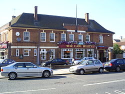 The Earl Beatty pub
The only local public house, The Earl Beatty, celebrates David Beatty, 1st Earl Beatty who commanded a large part of the British fleet at the Battle of Jutland in the First World War.
In 1931 the part of the Hobbald(e)s Farm estate was acquired by the Urban District of Merton and Morden to become the Sir Joseph Hood Memorial Playing Fields. One reason for their doing so was to perpetuate the name of local benefactor and ex-Mayor of Wimbledon, Sir Joseph Hood. The land was set out with a large pavilion, football and cricket pitches, tennis courts, bowling green, putting green and children's play areas. Part of the land is now being managed as a conservation and wildlife reserve.
The biggest local employer for decades was the Decca gramophone record company. In 1929 this was employing 700 people, and making up to 60,000 records a day at its factory in Burlington Road, New Malden. The company diversified during World War Two to make radar and the Decca Navigator System.
Other local employers from that era were, at Shannon Corner, the Shannon typewiter company and the Venner timeswitch company, maker of Britain's first parking meters. Also close to Shannon Corner were Carter's Seeds and Bradbury Wilkinson, a security printing company, maker of banknotes for many of the world's smaller countries. The Tesco hypermarket in the area occupies the former Bradbury Wilkinson site.
Sydney Charles Wooderson set the then world mile record of 4min 6.4sec at Motspur Park's University of London Athletics ground on August 28, 1938.
During World War Two a single stick of bombs was aimed at the railway station by a German bomber but missed its target and destroyed houses in Marina Avenue (including the six odd-numbered houses from 63 to 73) and Claremont Avenue. The bomb landing in Claremont Avenue landed on a 21st birthday party at a house very near the station killing many at the party. On the morning of July 3, 1944, a V1 rocket came down near No. 45 Motspur Park, the street that takes its name from the town. According to the archives manager at Kingston council, no casualties were reported, but seven or eight houses were completely destroyed, and others were badly damaged. B&Q owned the Agip site (next to West Barnes Library) in the mid to late 80s. The store was rather small and when the Burlington Retail Park was finally finished, B&Q sold the site and moved into a bigger property in New Malden instead.
In the 1970s to mid 1980s, there was a petrol station/garage in Motspur Park. It was called Jackson's Garage, owned and run by Caribbeans (it was located on the site of the former Apple office, now part of the Fulham Football Club office situated next to the level crossing). There were three newsagents/sweetshops/toyshops in the 1960s to 1970s - A.R. Waylett, Bromheads and the smaller 'Sweet Things and Things' which has now increased in size, the others being closed down. There was also a fishmonger (where the kebab shop now stands) an ironmonger (where the garage door sales shop now stands) three butchers, a Co-op store and the original Motspur Park library, which was situated at 359 West Barnes Lane, on the corner of Station Road, in the property now occupied by Kami's gents hairdressers. In the 1980s, a short-lived clothing store called 'Get Clobbered' was open. There were 2 banks in Motspur Park; a Lloyd's Bank situated near Motspur Park Food and Wine and a Midland Bank which was situated in the building left of Kami's. The Chinese take-away shop used to be a greengrocer, the shop to the right of the kebab shop used to be an Apollo Video Rental outlet.
Ghassans store was opened in 1988 and has changed and grown in time to become the local convenience store Ecklee. The store is now three units wide with a lebenese grill open a few shops down offering healthy food for the locals. Home delivery of grocery items from Ecklee is available from Ecklee.co.uk. It is one of the oldest businesses in the area still running today.
D.Jones shoe shop, the Earl Beatty Pub and Motspur Park station are the only buildings unaltered for use since the 1970s.
Famous residents
Col Joseph Husband, the inventor of the zebra crossing, lives in the area.
Nigel Winterburn (the former Arsenal and Wimbledon defender) lived in Motspur Park during the 1980s when he played for Wimbledon FC. Apparently, he was a regular at the bookies in Motspur Park.
George Clinton of Funkadelic and Parliament stayed in a house on Phyllis Avenue during his six-night residency at the London Astoria in 1976.
The village was occasionally mentioned in the BBC comedy series Brush Strokes.
Playing fields
The playing fields located at Motspur Park are:
-
- Fulham football club training ground, formerly the University of London Athletics ground. As an athletics track it served for scenes in films The Games (1970), Chariots of Fire (1981) and The Four Minute Mile (1988) (TV).
- The BBC F.C. sports club ground
- The King's College School sports ground
- The Joseph Hood Memorial playing field
- The Old Blues rugby club playing field
- The Tenison's School playing field
- Plus one other minor ground.
The former BBC sports ground - which is opposite Fulham F.C's training ground - occasionally featured in BBC comedy series such as The Two Ronnies and Monty Python's Flying Circus. The grounds and buildings were sold by the BBC in the late 1990s and became a private members' club before closing permanently after in a devastating fire in 2004.
Education
- For education in the Kingston portion of Motspur Park see the main Royal Borough of Kingston upon Thames article.
Nearby places
To the west:
Kingston upon Thames, Malden Manor, Old Malden
To the south:
Worcester Park, North Cheam
To the east:
Morden, Merton, Wimbledon
To the north:
New Malden, Raynes ParkSee also
Bibliography
- Jowett, Evelyn M. An Illustrated History of Merton and Morden Published Merton and Mordon Festival of Britain Local Committee (1951)
References
- ^ UK Running Track Directory Motspur Park, University of London Track. Accessed December 2006.
- ^ http://www.old-maps.co.uk/oldmaps/index_external.jsp?easting=522581&northing=167660 old-maps.co.uk
- ^ Motspur Park Holy Cross Description - The Diocese of Southwark. Accessed December 2006
- ^ Tarmac - Our history "In 1925 - 1926 the road fund report showed that 190 miles of arterial roads had been completed including the Kingston by pass - the first dual carriageway of its kind.
- Sir Joseph Hood Memorial Playing Fields A report for London Borough of Merton December 2006. Written by Alan Scott BSc. MSc. MIEEM. CEnv. Contains a study of the local wildlife and a local history.
- Raynes Park and West Barnes Residents' Association Links to many resources on local history.
- Potted History of New Malden Evangelical Free Church Accessed August 2007.
External links
- MotspurPark.info, a community website launched in May 2010 with What's On, news and features for the area
- Friends of Sir Joseph Hood Memorial Playing Field
- A map of the Motspur Park area in 1871
- Train times and station information for Motspur Park from National Rail
London Borough of Merton Districts Colliers Wood · Lower Morden · Merton Park · Mitcham · Morden · Morden Park · Motspur Park · Raynes Park · St Helier · South Wimbledon · West Barnes · Wimbledon · Wimbledon Park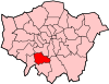
Attractions Constituencies Other topics People · Public art · SchoolsParks and open spaces in Merton Royal Borough of Kingston upon Thames Districts Berrylands · Chessington · Coombe · Kingston upon Thames · Kingston Vale · Motspur Park · New Malden · Norbiton · Old Malden · Surbiton · Tolworth · Hook, London · Malden Rushett
Attractions Constituencies Other topics People · Public art · SchoolsParks and open spaces in Kingston upon Thames Categories:- Districts of London
- Districts of Kingston upon Thames
- Districts of Merton
-


Wikimedia Foundation. 2010.