- Dorrington, Lincolnshire
-
Coordinates: 53°03′45″N 0°23′29″W / 53.0624°N 0.3914°W
Dorrington 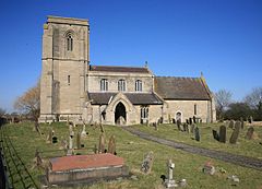
Sts James and John church, Dorrington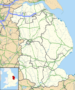
 Dorrington
Dorrington shown within LincolnshirePopulation 340 OS grid reference TF080529 - London 109 miles (175 km) S District North Kesteven Shire county Lincolnshire Region East Midlands Country England Sovereign state United Kingdom Post town LINCOLN Postcode district LN4 Dialling code 01526 Police Lincolnshire Fire Lincolnshire Ambulance East Midlands EU Parliament East Midlands List of places: UK • England • Lincolnshire Dorrington is a village and civil parish in the North Kesteven district of Lincolnshire, England. It lies 2 kilometres (1.2 mi) south of Digby and north of Ruskington. It is to the east of the north-south B1188, which lies just within the parish boundaries. The nearest town is Sleaford, approximately 7 kilometres (4.3 mi) to the south.
In the 2001 census, the parish had a population of 340.[1]
Dorrington Grade I listed Anglican church is dedicated to St James and St John.[2] It is mainly in Decorated style. On the sides of the east window are ogee canopied niches. The church tower previously held a spire. On the exterior of the east window is a sculpture of the Last Judgment.[3]
The church is situated on the B1188 approximately 0.5 miles (0.80 km) north-west of the village centre, overlooking the village. Frank Whittle lodged at a house in the village while developing the jet engine at RAF Cranwell; the remains of this house lie near the church.[4] In the village are the remains of a Grade II listed Medieval ashlar cross.[5][3]
The Peterborough to Lincoln Line passes to the east of the village.[6] The village public house is the Musicians Arms on Main Street.
References
- ^ "2001 Census: Key Statistics: Parish Headcounts: Area: Dorrington CP (Parish)". Neighbourhood Statistics. Office for National Statistics. http://neighbourhood.statistics.gov.uk/dissemination/LeadTableView.do?a=7&b=796328&c=Dorrington&d=16&e=15&g=467949&i=1001x1003x1004&m=0&r=1&s=1244816152911&enc=1&dsFamilyId=779. Retrieved 2009-06-12.
- ^ "Church of St James and St John", National Heritage List for England, English Heritage. Retrieved 22 July 2011
- ^ a b Cox, J. Charles (1916) Lincolnshire p. 118; Methuen & Co. Ltd
- ^ "Dorrington", Dorrington Parish Council. Retrieved 22 July 2011
- ^ "Cross", National Heritage List for England, English Heritage. Retrieved 22 July 2011
- ^ "Corner Bridge", geograph.org.uk. Retrieved 22 July 2011
External links
- "Dorrington", genuki.org.uk. Retrieved 22 July 2011
Coordinates: 53°03′45″N 0°23′29″W / 53.0624°N 0.3914°W
Categories:- Villages in Lincolnshire
- Civil parishes in Lincolnshire
- Lincolnshire geography stubs


Wikimedia Foundation. 2010.