- Graciosa, Canary Islands
Infobox Islands
name = La Graciosa
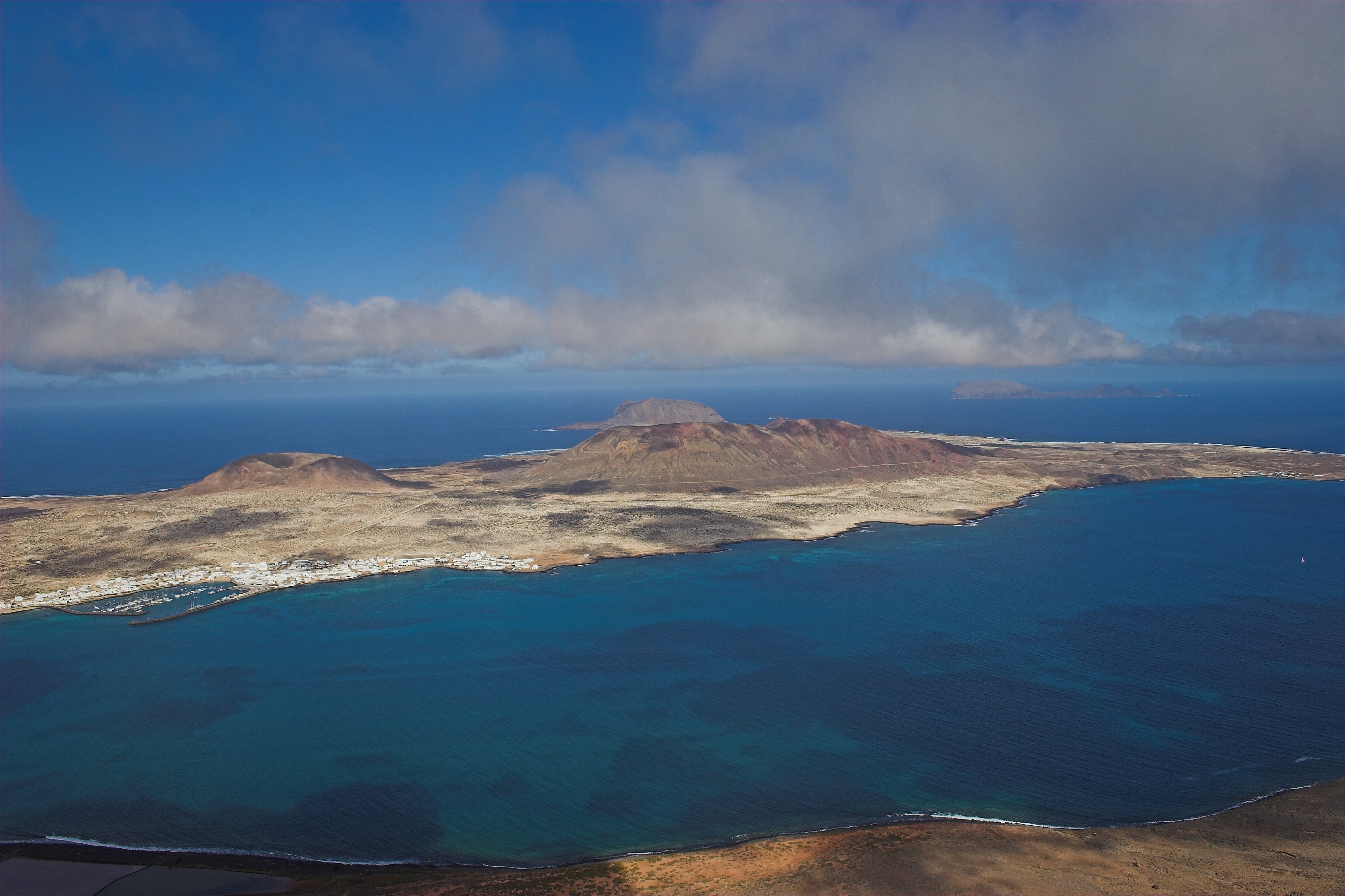
image caption = La Graciosa from Mirador Del Rio
image size =
locator
locator
Location map|Canary Islands|lat=29.233|long=-13.5
map_custom = yes
native name =
native name link =
nickname =
location =
coordinates =
archipelago =Canary Islands
total islands =
major islands =
area = 29.05 km²
highest mount = Las Agujas
elevation = 266 m
country = Spain
country admin divisions title = Autonomous Community
country admin divisions = flag|Canary Islands
country admin divisions title 1 = Province
country admin divisions 1 = Las Palmas
country admin divisions title 2 =
country admin divisions 2 =
country capital city =
country largest city =Caleta de Sebo
country largest city population = 656
country leader title =
country leader name =
population = 658
population as of = 2006
density = 21.93
ethnic groups =
additional info ="There is also a Graciosa in the
Azores , seeGraciosa "Graciosa Island or commonly La Graciosa (Spanish for ful) is a volcanic
island in theCanary Islands ofSpain , located 2 km north of the island ofLanzarote with the strait named Río. It was formed by theCanary hotspot . The island is part ofParque Natural del Archipiélago Chinijo , Reserve of the Biosphere, "Marine Reserve of La Graciosa and the islands to the North of Lanzarote" it is linked to the municipality of Teguise. The island forms a part of theChinijo Archipelago . The village is in the southeastern part of the island with houses encircling the harbor which has two piers and a yacht area in the bay. Other smaller islands includeMontaña Clara (Spanish for clear mountain) which is an archipelago to the northwest,Roque del Este ,Roque del Oeste andAlegranza to the north. The only two settlements include Caleta del Sebo and summerresidenceCasas de Pedro Barba . The island is entirely made up of volcanic rock and sands.The population is around 700. Tourism is the main industry along with fishing. Every year, tourists flock to the island for its tempered climate and its sandy volcanic coasts. The island has a school, lyceum, post office, supermarkets, a bank, port, beaches, and — except bar-restaurants — a square where bicycles can be hired ("
plaza ").Streets and roads on La Graciosa are unpaved sand. The Gracioseras can often be seen early each morning sweeping the streets smooth of the previous night's footprints. Motor vehicles are strictly prohibited and limited to a handful of licensed vehicles for special purposes. Since the roads are bad, and cars have to be shipped to Lanzarote for repair, about 70% of the motor vehicles on the island are old Land Rovers which often can be repaired by a local serviceman.
Access to the Island is by a thirtyfive-minute ferry crossing from
Orzola onLanzarote to the harbour in the village.Graciosa Island has been raided by
pirate s for treasures.Geographical features
As part of the easternmost islands in the archipelago, and th smallest inhabited Canary Island, the island is extremely arid and entirely made up of bushes and dry soil. Its length is about 8 km and the width is 4 km, equalling around 30 square kilometres. There are no natural water sources on the island but desalinated water has been piped directly from neighbouring Lanzarote since 2001.
The mountains lie to the northern and the western part. The southern and the eastern part are hilly. The tallest mountain is
Aguja Grandes rising to 266 m. The second tallest is "Las Agujas Chicas " at 228 m. Other mountains includeMontaña Amarilla (Spanish for yellow mountain), situated in the southwestern part and the crater-peakedMonte Bermeja to the northeast. It is partially eroding in the lower part. The elevation is 152 m.The island's many beaches include
Playa Francesa to the southwest, Playa de laCocina to the west, PlayaLambra to the east, and the magnificent Playa de las Conchas on the far side. Points include PuntaGorda .References
*Pott, Joachim/Hüppe, Joachim/de la Torre, Wofredo Wildpret "
Die Kanarischen Inseln. Natur- und Kulturlandschaften " = "The Canary Islands. Natural and Cultural Landscapes", Ulmer :Stuttgart 2003 , 320 S., 295 color photos, 28 colored graphica, 3 tables. (represented and illustrated byGeobotanik )External links
* [http://www.nordwestreisemagazin.de/graciosa/index.htm Info and photos of Graciosa]
* [http://www.ilanzarote.net/en/archipielago/graciosa.htm La Graciosa]
Wikimedia Foundation. 2010.