- Metro Beach Metropark
-
Metro Beach Metropark 
Sign along Black Creek welcoming boatersLocation within metro Detroit
Type Regional park Location Lower Peninsula, Macomb County, Michigan USA Coordinates 42°34′32″N 82°47′57″W / 42.57569°N 82.7993°WCoordinates: 42°34′32″N 82°47′57″W / 42.57569°N 82.7993°W Area 770 acres (310 ha) Operated by Huron–Clinton Metroparks Status Open year round Website Official site Metro Beach Metropark is a 770 acre (3.1 km²) unit of the Huron-Clinton Metroparks system located roughly 16 miles (26 km) north of downtown Detroit, Michigan in Harrison Township, Macomb County. Metro Beach has been in existence since 1950 and has changed much since those times. The main attractions in Metro Beach are the beach on Lake St. Clair, the marinas and boat launches, the pool with two water slides and diving boards, the "Squirt Zone" where kids can play with equipment that shoots water, the 18 hole, Par 3 golf course, the fitness/biking/crosscountry ski trails, and the Nature Study Area and Nature Center where 275 species of birds have been recorded. A 1600-foot boardwalk follows part of the Lake St. Clair shoreline in the park.[1] The park is located at Jefferson Avenue and Metropolitan Parkway (16 Mile Road) and there are signs to Metro Beach on I-94.[2]
Due to sewage overflows, the Lake St. Clair beach sees occasional closures caused by high E. coli counts. In the 2009 season, there were 9 days of closure.[3]
Miscellaneous Trivia
- The end that extends into Lake St. Clair was originally an island.
- The paved fitness trail runs for 4 miles (6.4 km) inside the confines of the park.
- On a clear day, the Renaissance Center in Detroit is visible over Lake St. Clair.
- Despite being in a suburban area, there are deer that live within Metro Beach like many other areas in Metro Detroit.
References
- ^ 109 Metro Beach Metropark , Michigan DNR
- ^ Metro Beach Metropark Huron-Clinton Metroparks
- ^ Pollution closes Metro Beach to swimming, The Macomb Daily, June 04, 2010
External links
Parks in metropolitan Detroit Detroit city Belle Isle • Campau Park • Campus Martius • Chandler Park • Clark Park • Central Park • Dequindre Cut • International Riverfront • Engel Memorial Park • Ford Park • Fort Wayne • Gabriel Richard Park • Grand Circus • Layfayette Park • New Center Park • Owen Park • Palmer Park • Patton Park • Reid Memorial Park • State Fairgrounds • Three Mile Drive Park • Roosevelt Park
Metro
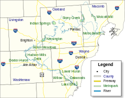
600 to 1,500 acres (243 to 607 ha)Addison Oaks • Algonac State Park • Belle Isle • Camp Dearborn • Crosswinds Marsh • Hayes State Park (Irish Hills) • Independence Oaks • Lower Huron • Metamora-Hadley Recreation Area • Metro Beach Metropark • River Rouge Park • Sterling State Park1,500 to 5,000 acres (607 to 2,023 ha) Bald Mountain • Brighton Recreation Area •
Hines Drive • Hudson Mills • Huron Meadows • Indian Springs • Kensington • Lake Erie Metropark • Pontiac Lake Recreation Area • Oakwoods • Pointe Mouillee State Game Area • Stony Creek Metropark • Wolcott Mill • Willowover 5,000 acres (2,023 ha) Detroit River International Wildlife Refuge • Highland Recreation Area • Ortonville Recreation Area • Waterloo State Recreation AreaWaterways Major beaches Belle Isle • Kensington • Lakeside Beach and Park • Lighthouse Beach and Park • Metro Beach • Stony CreekTrails
5 to 36 miles (8 to 58 km)Bald Mountain • Detroit River Walk / Dequindre Cut • Highland Recreation Lakes • Kensington • Lakelands Trail State Park • Maybury State Park • Novi North Park • Paint Creek Trail • Poly Ann Trail • Pontiac Lake Recreation Area • Stony Creek Inwood Trails • Waterloo-Pinckney TrailZoological and botanical See also Tourism in metropolitan Detroit and Huron-Clinton Metroparks
Metro Detroit Topics Architecture · Culture · Detroit River · Economy · Freeways · History · Historic places · International Riverfront · Lake St. Clair · Media · Music · Parks and beaches · People · Skyscrapers · Sports · Theatre · Tourism · Transportation
Major city Municipalities
over 80,000Canton Township · Clinton Township · Dearborn · Livonia · Sterling Heights · Troy · Warren · WestlandMunicipalities
45,000 to 80,000Dearborn Heights · Farmington Hills · Grosse Pointe · Macomb Township · Novi · Pontiac · Redford Township · Rochester Hills · Royal Oak · St. Clair Shores · Shelby Township · Southfield · Taylor · Waterford Township · West Bloomfield TownshipSatellite cities Counties in MSA Counties in CSA Regions Outlying regions Categories:- Landmarks in Michigan
- Huron–Clinton Metroparks
- Parks in Michigan
- Coastal resorts in Michigan
- Beaches of Michigan
- Protected areas of Macomb County, Michigan

Wikimedia Foundation. 2010.