- Church Village
-
Coordinates: 51°34′12″N 3°19′18″W / 51.569920°N 3.321605°W
Church Village Welsh: Pentre'r Eglwys 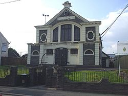
Old Carnegie Library, Church Village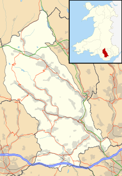
 Church Village
Church Village shown within Rhondda Cynon TafPopulation 3,320 [1] Principal area Rhondda Cynon Taf Ceremonial county Mid Glamorgan Country Wales Sovereign state United Kingdom Post town PONTYPRIDD Postcode district CF38 Dialling code 01443 Police South Wales Fire South Wales Ambulance Welsh EU Parliament Wales UK Parliament Pontypridd Welsh Assembly Pontypridd,
South Wales Central Electoral RegionList of places: UK • Wales • Rhondda Cynon Taf Church Village (Welsh: Pentre'r Eglwys) is a large village in the historic parish and community of Llantwit Fardre, located within the Taff Ely district of the County Borough of Rhondda Cynon Taf in Wales. The village is centrally located being around 4 miles from the local principal towns of Llantrisant to the southwest and Pontypridd to the north and is situated around 10 miles northwest of Cardiff city centre. Historically it was known as Cross Inn and fell within the traditional county of Glamorgan.
Church Village itself does not share the extent of industrial mining heritage of much of the rest of the county and largely comprises new and recent build housing. It is a rapidly growing urban area, today almost a town rather than a village, being much sought after to live in due to its proximity to Cardiff and Pontyclun. Church Village is also commonly used to refer to the whole CF38 postcode area of Pontypridd, comprising the adjoining principal settlements of - Beddau, Efail Isaf, Llantwit Fardre, Ton-teg, Tyn-y-Nant and Upper Church Village.
Church village was served by Church Village railway station on the Llantrisant and Taff Vale Junction Railway until 1964.
Costain, under contract from Rhondda Cynon Taf County Borough Council constructed a bypass to reduce traffic congestion on the A473, Pontypridd to Bridgend (Welsh: Penybont) road, from Cross Inn, near Llantrisant, to Tonteg via Efail Isaf. The Church Village bypass, which is built as a single carriageway, with crawler and overtaking lanes around roundabouts opened in September 2010.[2][3]
Contents
Education
Church Village is the site of one of the newest school sites in Wales, which is called Gartholwg Community Campus. This initiative houses a primary school - Ysgol Gynradd Gymraeg Garth Olwg, a secondary school - Ysgol Gyfun Garth Olwg, a pre-school nursery, a community library, Lifelong Learning Centre and a Youth centre.
Religion
There are three Christian churches in the area, St. Illtyd's, the Parish church, Capel Y Bedyddwyr Cymraeg Salem (Salem Welsh Baptist Chapel, with English and Welsh services) and Bethel Baptist Chapel. All three churches have a strong and healthy relationship between them which is constantly developing. The Parish church of St. Illtyd's has been serving the community for hundreds of years, but Salem and Bethel have developed in the last 100 years. Bethel was formed owing to schismn, wishing for English services compared to the, then, complete Welsh Salem which was already established in the area. However, in the last 50 years Salem adopted an evening English service and is enjoying a morning family service under the current Pastor. Salem Chapel is widely known as the chapel (and resting place) of former Deacon and Arweinydd y gan, John Hughes, who wrote the famous hymn tune Cwm Rhondda (Guide Me, O Thou Great Jehovah).
External links
- Gartholwg Community Campus
- www.geograph.co.uk : photos of Church Village and surrounding area
- Ysgol Gyfun Rhydfelen school website
References
- ^ National Office for Statistics (2001)
- ^ "Church Village Bypass - Web Online". Church Village Bypass website. Rhondda Cynon Taf CBC, Costain and the Welsh Assembly Government. 2009. http://www.churchvillagebypass.com/. Retrieved 2009-04-175.
- ^ "WalesOnline - News - South Wales Valleys - Pontypridd & Llantrisant - Safety worries discounted as bypass work begins". Wayne Nowaczyk, Pontypridd Observer. Media Wales Ltd.. 2008-12-11. http://www.walesonline.co.uk/news/south-wales-news/pontypridd-llantrisant/2008/12/11/safety-worries-discounted-as-bypass-work-begins-91466-22442125/. Retrieved 2009-04-17.
Categories:- Villages in Rhondda Cynon Taf


Wikimedia Foundation. 2010.